The strong ocean anomaly is called the Indian Ocean Dipole, or IOD. It is an imbalance in pressure and wind patterns in the Indian Ocean, but it has a very broad influence, as it is connected to the global weather circulation. Especially when combined with the large-scale El Niño event.
Ocean anomalies are always closely monitored, especially when we get closer to Winter. That is usually due to their known influence on atmospheric motion and pressure patterns.
Despite being seemingly in another part of the world, it does also have a global reach, but perhaps not in the most direct way. As you will see, the atmosphere is constantly in motion, and the global weather is just one big system.
INDIAN OCEAN DIPOLE PATTERN
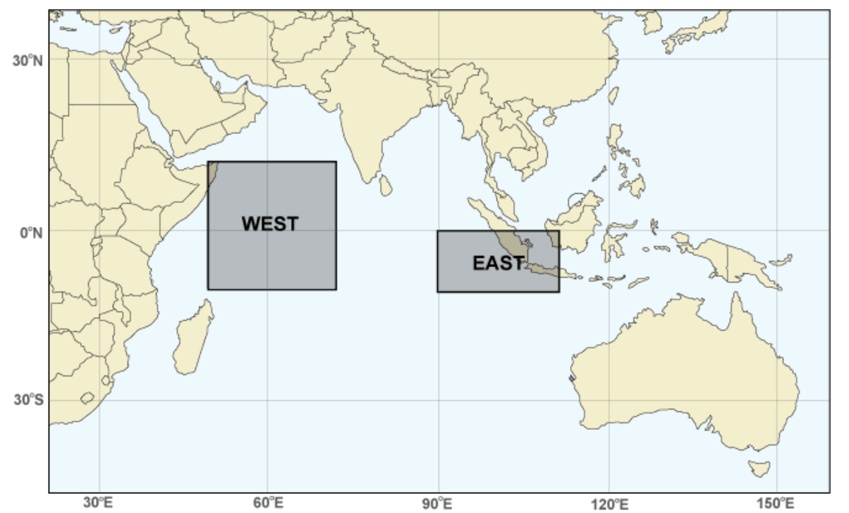
Indian Ocean Dipole (IOD) anomaly is found in the Indian Ocean and consists of two poles, hence the name “dipole.” The east part of this anomaly is located around Indonesia, and the west part covers the western Indian Ocean.
The IOD is basically an imbalance in ocean temperatures between these two regions, east and west. Changes in ocean temperatures between the regions occur due to the change in trade wind patterns. Thus, the IOD has two phases, positive and negative.
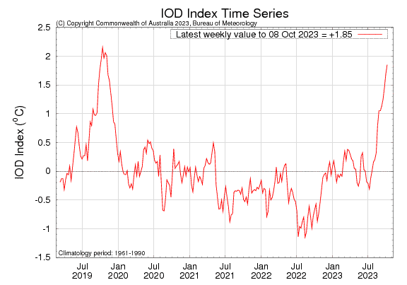
Looking at the latest weekly graph analysis, you can see that we are in a strong positive phase of the IOD. The latest 2023 event is actually the strongest positive phase since 2019 and the second strongest in the past 25 years.
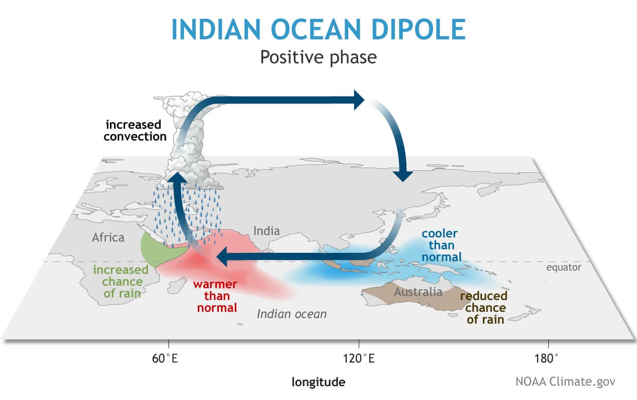
Below, you can see the typical atmospheric circulation pattern during a positive IOD phase. In a positive phase, the air is sinking in the eastern region and rising in the western region. That creates a large-scale atmospheric circulation, increasing the importance of the IOD to a much larger scale than just regional. Image by NOAA-Climate.
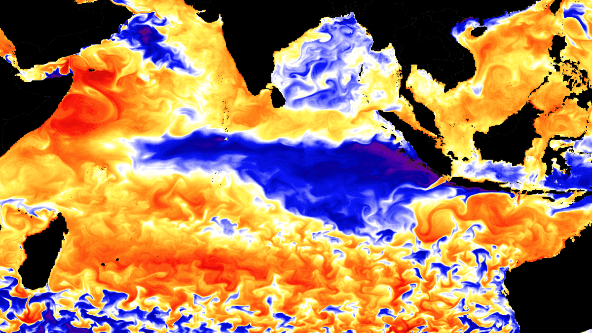
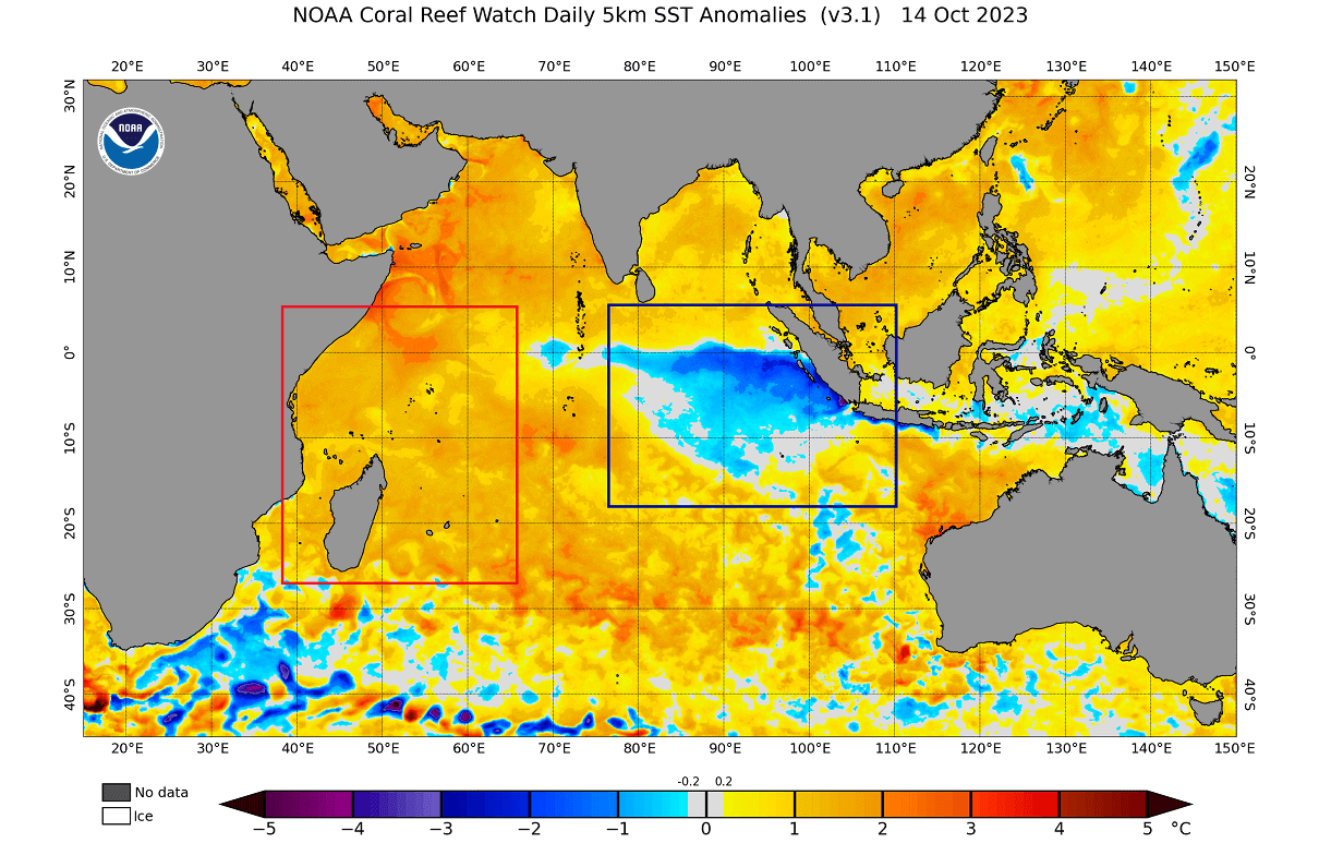
LATEST OCEAN ANALYSIS DATA
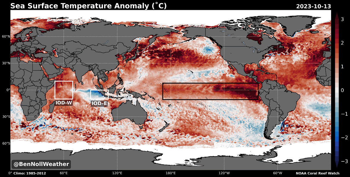
The latest ocean analysis shows a temperature difference between the eastern and western regions of the Indian Ocean. So you can see colder anomalies in the east, but in the western parts, we see warmer anomalies. This corresponds to a positive IOD pattern.
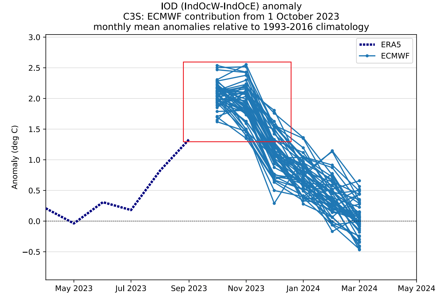
You can see this development in the ECMWF seasonal forecast below. A strong positive IOD phase is expected to reach its peak in late Fall, with the atmospheric interference expected to extend into Winter 2023/2024.
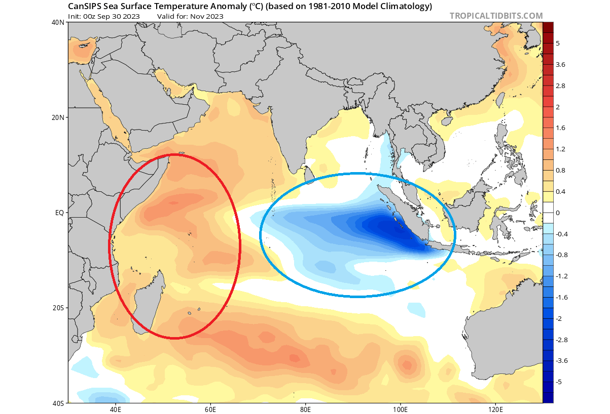
Looking also at the Canadian CanSIPS seasonal forecast, we can see the ocean temperature forecast for late Fall. Again, you can see warm anomalies in the west and cold anomalies in the east. This is a strong positive IOD pattern.
But this ocean anomaly is connected to another oceanic behemoth not too far away.
IOD AND El Niño
When talking about ocean anomalies, we cannot go past the El Niño event. We talked about it in much more detail in our latest update article, which will be linked at the bottom of the article.
But looking at the image below, we have the typical ocean temperature anomaly pattern for a positive IOD event. You can see it marked across the Indian Ocean, having an opposite temperature pattern in the east and west regions.
But notice in the Pacific Ocean how there is also a large warm anomaly. That is the ENSO region, and the warm anomalies are the El Niño phase. What this tells us is that the overall atmospheric circulation that creates El Niño conditions is also helping to create a positive IOD phase. So, it is a very delicate and connected feedback system.
Below, we have the latest global ocean temperature anomaly, and you can see the main regions marked in the image by meteorologist Ben Noll. Notice the opposing anomalies of the IOD regions and the strong warm anomaly of the El Niño region in the Pacific Ocean.
These ocean anomalies are connected and created via the global trade winds. You can see the effects of the trade winds in the video below. It shows the ocean temperature anomalies from late Winter to mid-summer 2023 across the ENSO regions.
The cold La Niña anomalies quickly broke down over the Winter, with warm anomalies emerging in early Spring. Notice the motion of the anomalies, being driven by the trade winds.
Another way to look for El Niño is actually in the atmosphere. Below is a graphic that shows the usual atmospheric circulation during an El Niño event.
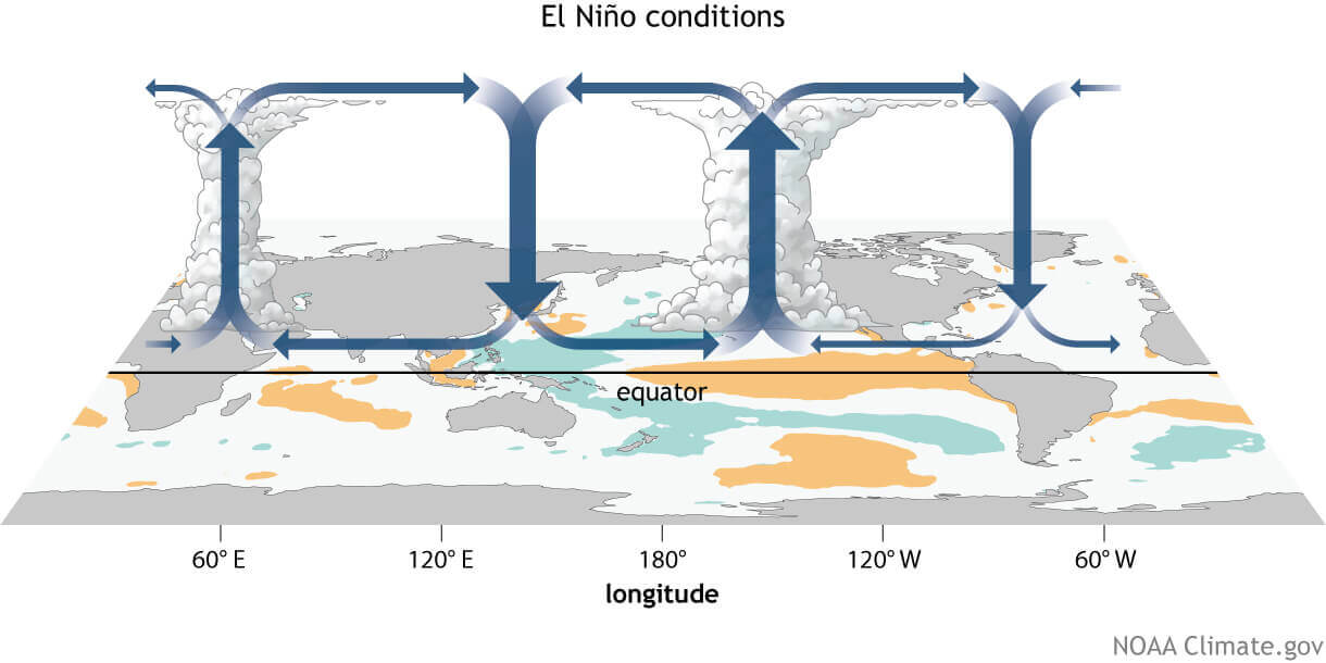
You can see strong rising motion in the eastern and central tropical Pacific, creating clouds and precipitation. Over the western Pacific and the Indian Ocean, you can see strong descending (sinking) motion. That causes fewer clouds and drier weather and directly responds to a positive IOD phase.
Below is a forecast map for December 2023. It shows the atmospheric vertical motion at around 12km (7.5 miles) altitude. Blue hues indicate rising air, and brown hues indicate sinking air. You can see strong atmospheric motion in the IOD region being forecast.
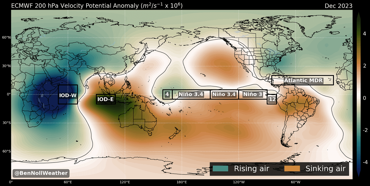
There is also the expected rising motion across the ENSO regions. All in all, it nicely shows just how these ocean anomalies and their circulation can get connected into the global atmosphere, providing their own impact on Winter or other seasons.
IOD WINTER INFLUENCE
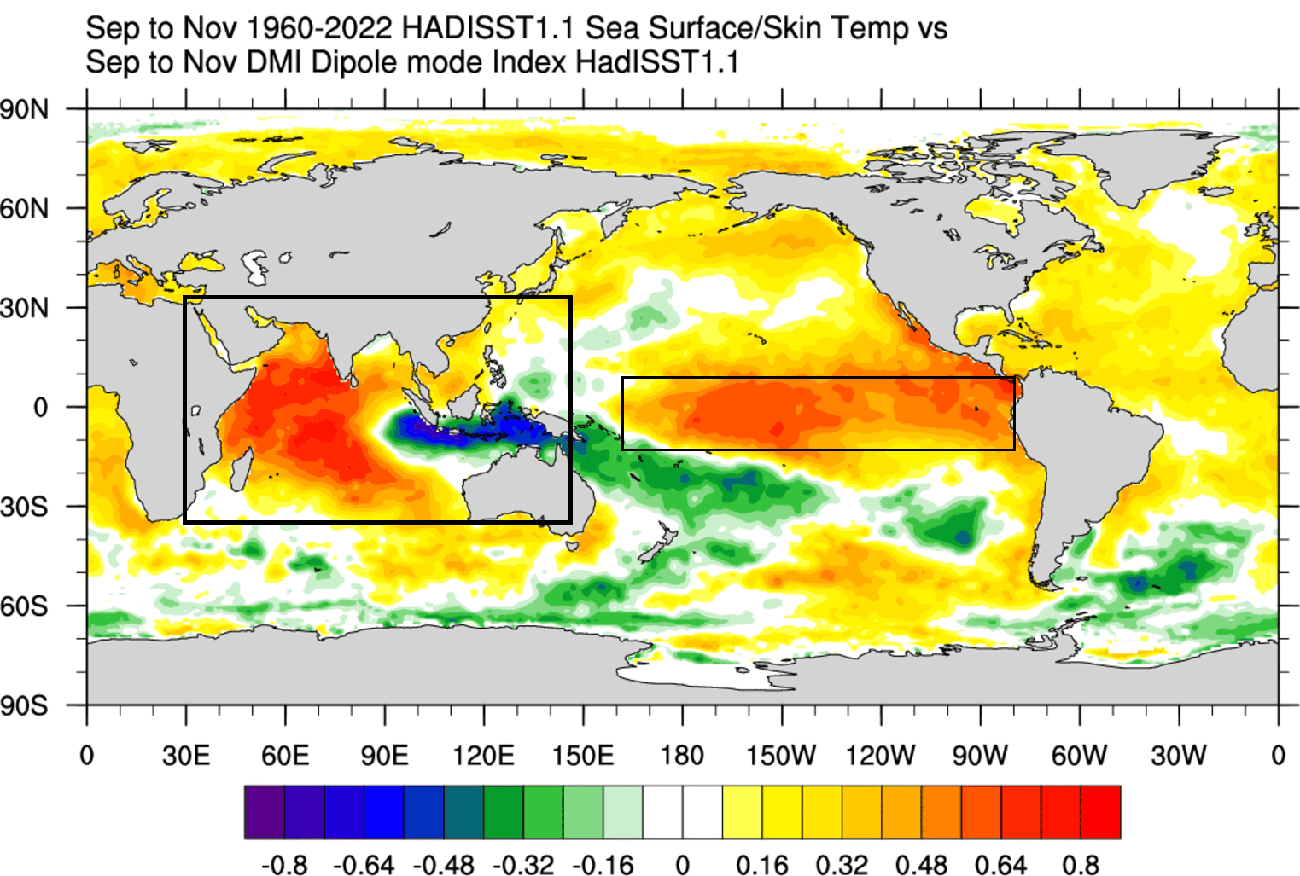
Of course, historically, it is important to know what a strong positive IOD means for the Winter season. Below is a 60-year correlation between IOD and the 500mb geopotential height pattern in the winter season.
We can see high-pressure anomalies over Canada and ridging into Europe during a positive IOD. A low-pressure area extends into the southern United States and over the North Atlantic.

This pattern is not far from a typical El Niño pattern. That is because the mechanics behind the IOD are related to the driving mechanism of the El Niño. Overall, it all interferes with each other and impacts the Winter climate.
Below is the IOD winter temperature signal, focused on North America and Europe. A positive IOD supports colder temperatures over the southwestern and southern United States and the plains. But a warmer signal is seen over the northern and eastern United States, Canada, and Europe.

These images are correlation data, comparing past atmospheric data with ocean data and trying to find a connection.
As El Niño and IOD change the weather globally, hardly a corner of the world does not feel its effect. However, local weather systems play a specific role, as well as other global weather drivers.
That is why the past/historical data can only give us a limited insight into what kind of Winter pattern to expect from these ocean anomalies across the United States, Canada, and Europe.
We will keep you updated on global weather development and long-range outlooks, so make sure to bookmark our page. Also, if you have seen this article in the Google App (Discover) feed, click the like (♥) button to see more of our forecasts and our latest articles on weather and nature in general.
Don’t miss: