December 2020 is here, already with some proper winter weather and defying La Nina’s influence in the process. But the “beast from the Ocean” is ready to take over the rest of the month. We will look at the latest forecast trends, and how the December weather is likely to develop.
We will take a weekly approach, breaking down the month into weekly periods, looking at the pressure patterns and the corresponding weather and temperature distributions.
Since this period is over 30 days long, we will be using the ensemble forecast system. This means that the forecast is composed of several individual calculations. The final forecast is an average of all the calculations, showing the prevailing idea and the main trend.
WINTER 2020/2021 START
The meteorological winter starts on December 1st and lasts till February 28/29th. In this period, all the official winter statistics are being recorded. December to February period covers the 3 coldest months of the year, which is why this is designated as the meteorological winter period.
Before winter, a lot has been said about the influence of the cold ENSO phase, the La Nina, in our latest winter forecast. To keep it simple, ENSO is a region in the eastern tropical Pacific ocean, which alternates between cold and warm phases. The tropical trade winds (easterly winds that circle the Earth near the equator) usually initiate or stop a certain phase, as they mix the ocean surface waters and alter the ocean currents.
We produced a high-resolution video, which shows the birth of La Nina, as colder waters emerged from the tropical Pacific Ocean.
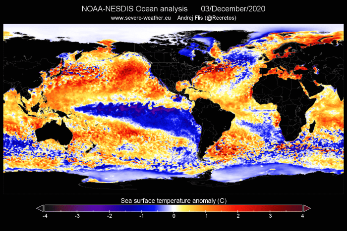
Below is the latest ocean temperature analysis. It reveals the large area of colder than normal waters in the equatorial Pacific ocean. This is known as the cold ENSO phase, La Nina. Also important to note is the warmer than normal North Pacific ocean.
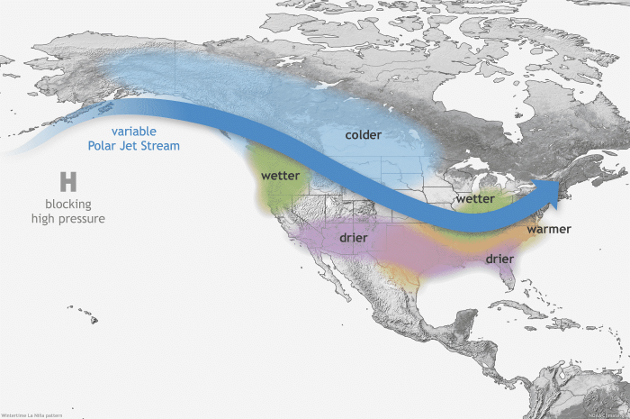
Each ENSO phase has a specific influence on the weather around the world. The image below shows the typical La Nina winter influence over North America. The variable polar jet stream brings colder air down from Canada into northern and the northwestern United States, and warmer and drier weather to the southern parts.
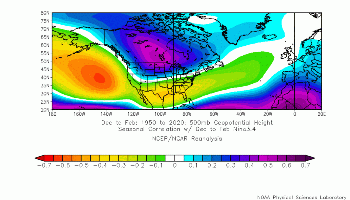
Looking at a typical La Nina pressure pattern, we can see why the jet stream is so bent. The most common feature of La Nina is a strong high-pressure system in the North Pacific. That in turn corresponds with a low-pressure area over western and central Canada. This pressure pattern creates this shape of the jet stream, keeping the colder air further north, and the southern United States under warmer air.
Over Europe, the direct La Nina influence slowly fades, due to pattern variability. The influence is still there, but it is mitigated/modified by the existing weather patterns in the North Atlantic.
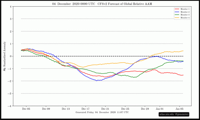
One way of searching for the “fingerprint” of the La Nina, is by looking at the atmospheric circulation, more specifically its angular momentum. Keeping it very simple, the Atmospheric Angular Momentum (AAM) is a measure of how the entire atmosphere rotates around the Earth.
Positive anomalies are related to the positive phase of the ENSO, while negative values are more related to the negative ENSO phase, namely La Nina. So far in early December, we saw positive values, indicating a weak influence of the La Nina. But that is soon to change, as the negative values indicate a stronger La Nina influence is to come.
DECEMBER WEATHER – WEEK 1
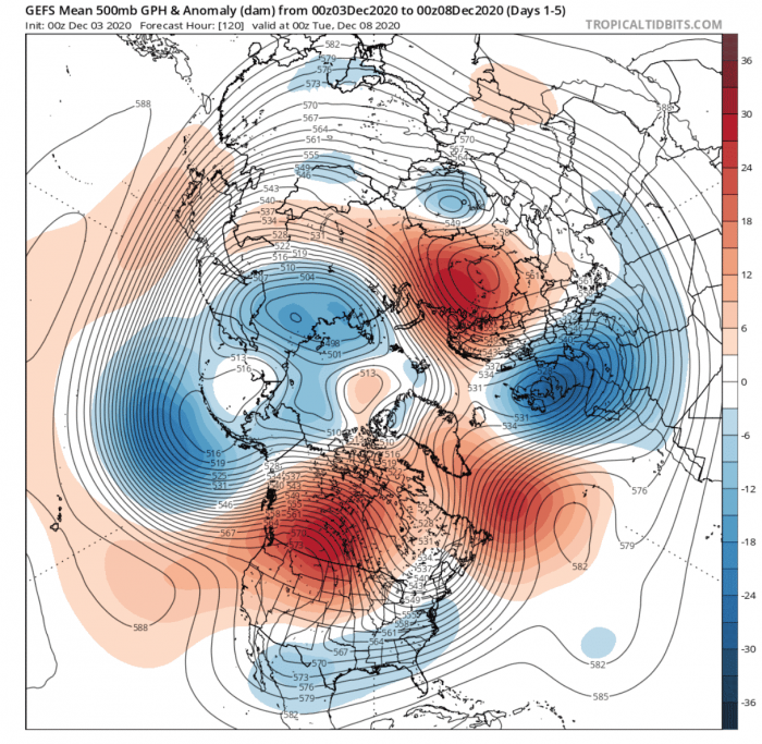
The pressure pattern for week 1 of December weather, shows a completely opposite pattern to the one expected from the La Nina. We have high pressure over western and central Canada and low pressure over the southern United States.
We can also see a massive low-pressure area over entire western Europe. Both Europe and North America are connected in the pattern by the strong high-pressure system in the North Atlantic.
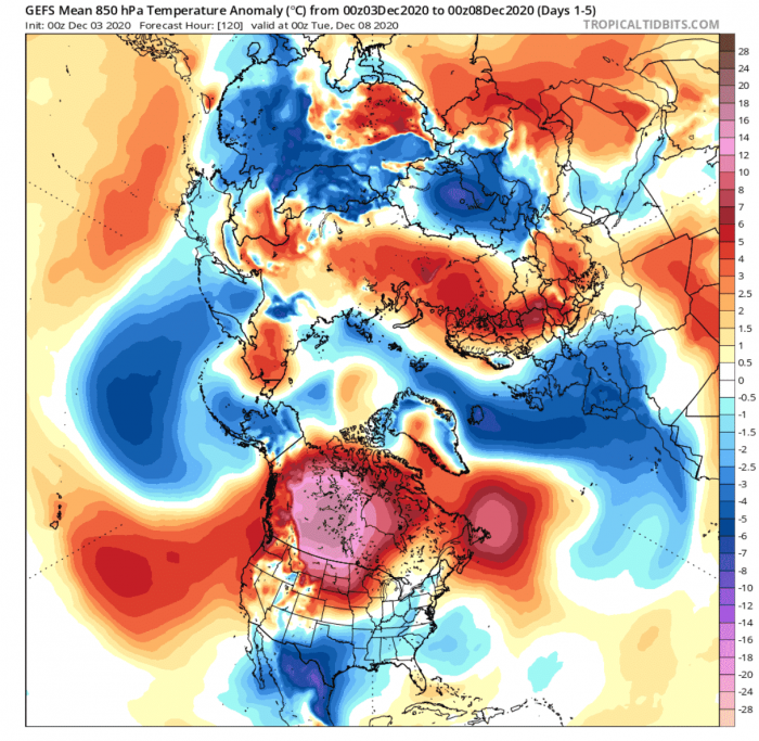
Europe – The temperature anomalies over the weekly average show a cold air outbreak over western Europe. This is the result of the strong low-pressure system over northwestern/western europe, which pumps the colder air directly from the north/northwest. But this also means that on the eastern side of this low-pressure system, we have a warmer south flow. Warmer than normal temperatures are seen in eastern Europe, reaching up towards Scnadinavia.
North America – Here we see a complete anti-La Nina picture. A strong warm wave is present over western and central Canada, while colder air is present over the south and the southeast United States. This is a classical example of a positive PNA (Pacific North American) pattern, more common during El Nino years (warm ENSO), which makes this week a rather interesting one.
The warm wave over Canada will persist, with a new colder wave entering the eastern United States by the end of week 1.
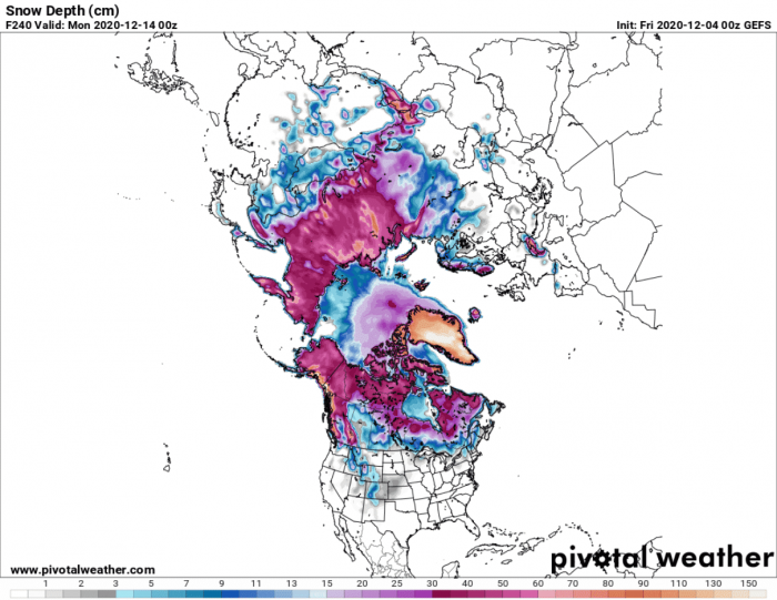
Snow Forecast – Looking at the snow depth forecast by the end of the first week of December, we see a general lack of significant snow cover over the United States and Europe. But we can see quite significant snow accumulations over the Alps and Scandinavia.
DECEMBER WEATHER – WEEK 2
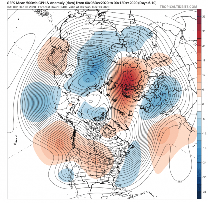
In week 2 of December, we will see some pattern progression over North America, but very little over Europe.
Looking over Europe first, the strong low-pressure system is still anchored over western Europe. It is being held in place by the strong high-pressure system over the Urals and Scandinavia. This will hold the northerly flow over western Europe, while warmer southerly flow will dominate eastern Europe and Scandinavia.
Over North America, we can see that the high pressure has retracted down from Canada into the continental United States. Low pressure is moving further out into the North Atlantic. This weekly average, however, does not show the full picture. By the end of week 2, the pattern progresses further, as the high-pressure area moves into the eastern United States, and a low-pressure system moves in from the west.
The pressure will be dropping at this point in Canada, setting the stage for next week.
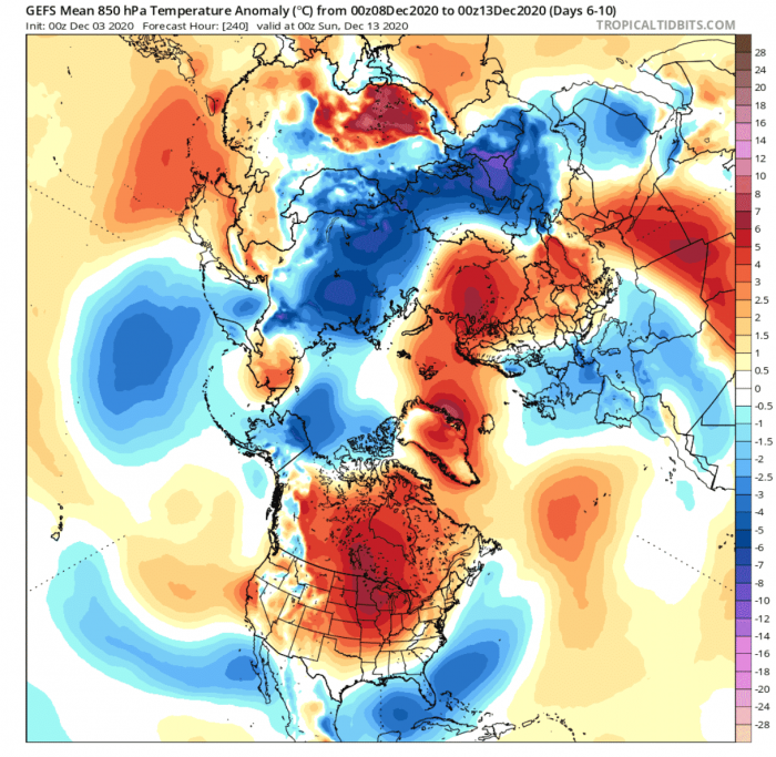
Europe – The persistent pressure pattern over Europe, continues the temperature distribution from week 1. Colder air will persist over western Europe, while southerly flow will hold warmer airmass over eastern Europe. But the colder air over western Europe will slowly warm-up, as no new colder air outbreaks are forecast in this period.
North America – The warmer airmass will move along with the high pressure, into the continental United States. The colder air will out temporarily, but what is not seen in this weekly average, is that a colder air mass will return over the western Untied states by the end of week 2, as the high pressure enters the picture in the west. The warm air will move towards the east, and out into the Atlantic.
Worthy of note is a strong cold air outbreak setting up in the parts of Central Asia, powered by the strong high-pressure system over the Urals and Scandinavia, which we mentioned before.
Snow Forecast – The snow depth forecast for week 2 does not show an obvious snow depth increase over Europe. In the United States, we do see hints of some snow cover increase over the Rockies and into the central United States towards the end of week 2, when the low-pressure area moves in from the west.
From this point, we will also be introducing the ECMWF extended ensemble forecast into the picture. It will add a new perspective to the forecast, helping to boost the confidence in the initial basic forecast by the GEFS model above.
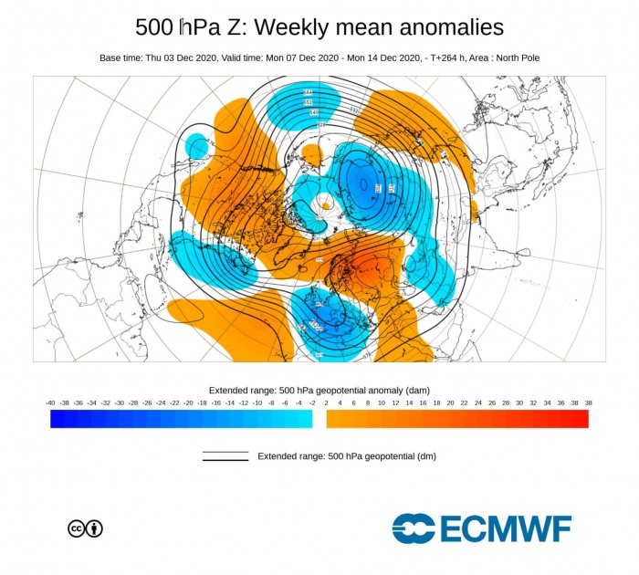
Week 2 forecast from ECMWF shows a very similar story to the GEFS model we have seen above. High pressure is receding from Canada into the United States, as the low pressure is moving out into the Atlantic. Over Europe, we have the quasi-stationary low-pressure system over western Europe and the strong blocking high over the Urals and Scandinavia.
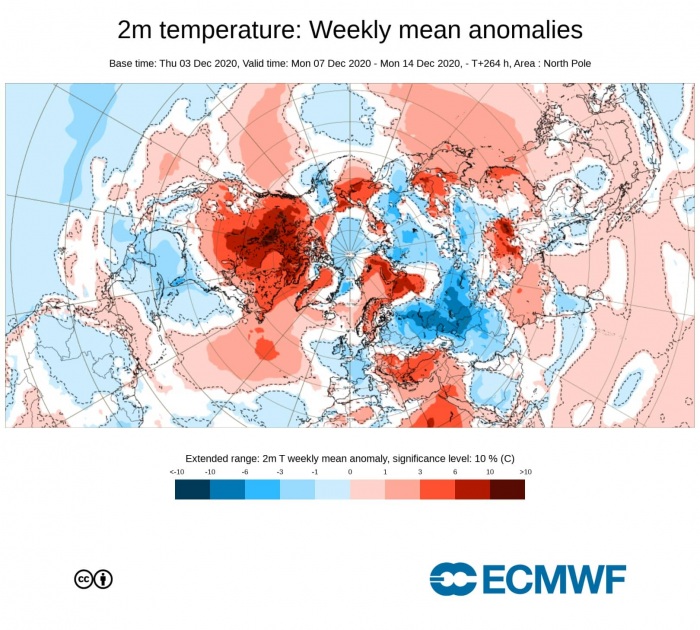
The surface temperature forecast is somewhat different over Europe. Especially in the far eastern parts, where we can see colder air anomalies. This is mainly due to the high-pressure system there being further north into Scandinavia, which allows colder air transport from the east.
Over North America, we have the warmer than normal airmass slowly receding from Canada down into the United States, pushing the colder than normal air out from the eastern and southeastern United states.
DECEMBER WEATHER – WEEK 3
Going further into week 3, a new problem is introduced. As we use an ensemble forecasting system, it means that the final forecast is made out of several different/individual calculations, which are averaged out to produce one single forecast. At short term forecasting, up to 3 or 4 days, most calculations show a fairly similar picture. Tho further into the future we go, the difference between these calculations can increase quite significantly. That is also called the spread.
This just means that the forecast is showing weaker signals, as the calculated scenarios are getting very different further in time. We can still look at the forecast to search for trends, but we need to understand that the spread is getting very big at this point. One way to mitigate this is to use different forecasting systems, which is why we introduced the ECMWF ensemble forecast system in the previous week 2 segment. Week 3 is also where bigger differences usually start to occur between different ensemble systems.
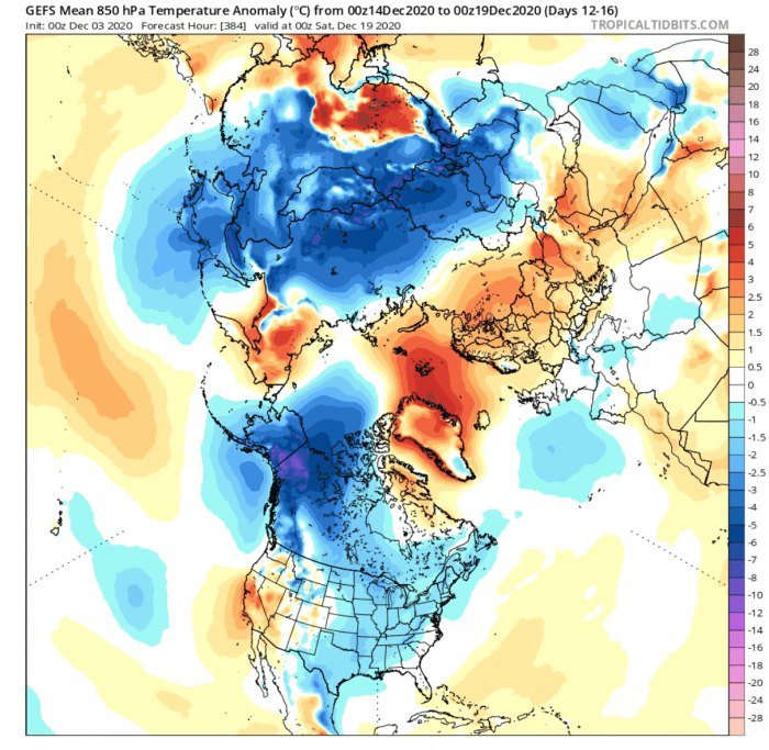
First, looking at the GEFS, it shows progression over North America, as the high-pressure system has now moved out into the Atlantic. In its wake, a new trough is descending into the eastern United States to fill the gap. Over Canada, the low-pressure system is starting to get more established, as a high-pressure system build further west in the North Pacific. This is starting to reflect the expected La Nina pattern, and it does look like it is starting to feel the influence of La Nina.
Over Europe, the situation seems more stagnant, with the ongoing high pressure blocking over Scandinavia and the Urals. There is a lack of a strong low-pressure system, but that could be due to the large spread in the forecast, which cant pinpoint a low-pressure area with enough confidence. A likely scenario with the continued high pressure over Northern Europe is the lower pressure over northwest and western Europe.
Europe – With higher pressure that is indicated over northern Europe and lower pressure over northwest/western Europe, it is safe to assume there is at least some continued colder air transport into western Europe and parts of east/central Europe. We can see it on the temperature anomaly forecast below, but the signal is not strong. A lot depends on the strength and positioning of the low-pressure system.
North America – Over North America, we can see the cold air outbreak/transport into central and eastern United States. This is kinda a “hybrid” situation, as western Canada is also starting to cool, indicating a more La Nina type pattern is emerging. This could indicate that a change is coming for the southern and eastern United States in the coming week 4. A warm wave is already building in the southwestern United States and could reach central parts by the end of week 3.
In the meantime, we can see the cold air outbreak over central Asia is still ongoing and has spread towards eastern Asia as well.
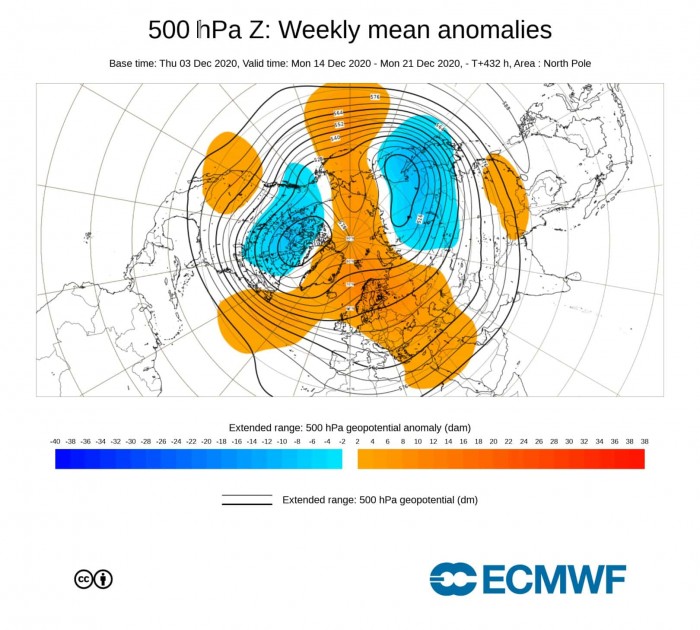
The week 3 December weather pattern from ECMWF is surprisingly similar to the GEFS above, which is not a common occurrence. We see the low-pressure area establishing over western and central Canada, with a trough extending down into the eastern United States. This is again looking like a “hybrid” pattern, indicating a transition towards a more classical La Nina type pattern.
Over Europe, the forecast is also very similar to the GEFS, with the established high-pressure system, and a lack of a defined low-pressure area in the west. But such a configuration is supportive of a low-pressure area centered over northwestern Europe.
Note the large and strong low-pressure area over the Russian Siberia, which is driving the strong cold air outbreak over central and also parts of eastern Asia.
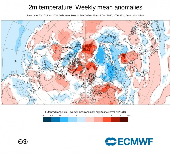
Temperature-wise, the ECWMF forecast also shows the cold air period over the eastern United States, with the anomalies showing the cold air reaching down into the southeast. In the west, a warm wave is setting up, which is likely to replace the cold air in the east in week 4.
Over Europe, we see no strong cold air anomalies. A negative patch near the British Isles is partly due to the colder ocean temperatures there and partially because of a likely low-pressure system in the area of the British Isles and western Europe. That would enable some colder air in western Europe again, possibly spreading into central Europe, if the low-pressure area would be further to the north.
DECEMBER WEATHER – WEEK 4
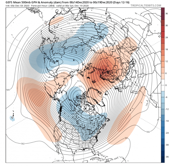
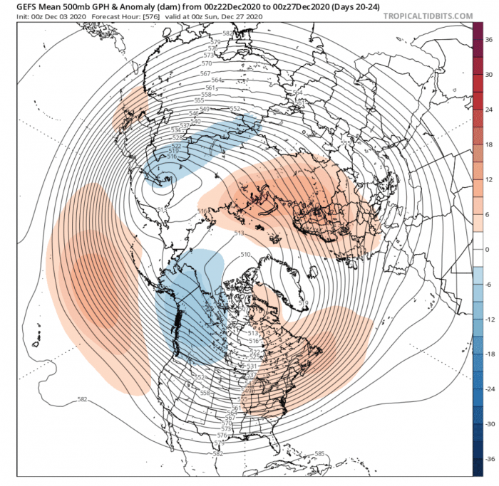
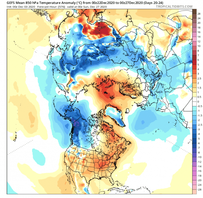
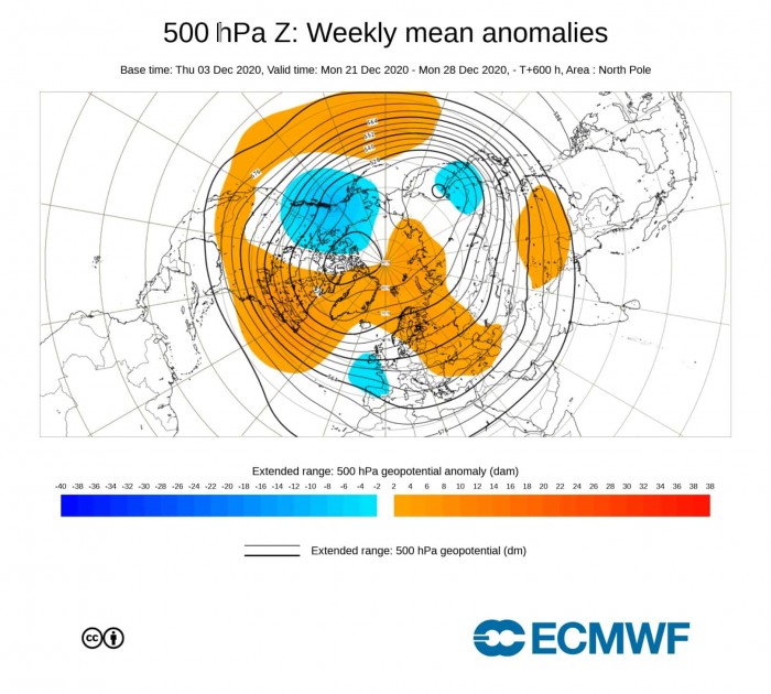
At week 4, we can see very clearly how the La Nina is now really taking over. The December weather pattern over North America is now a very typical La Nina pattern, with a low-pressure area over western/central Canada, and a high-pressure system in North Pacific and eastern the United States and Canada.
Over Europe, we still have the persistent blocking high-pressure system over Northern Europe. There is a lack of any low-pressure area to be seen, but that is due to the large spread in the forecast. Such configuration enables a low-pressure area over northwestern Europe.
Europe – Despite no low-pressure area is seen over northwestern Europe, the higher pressure over Scandinavia does tell the tale. A high-pressure area spins clockwise, meaning that it would promote northerly/easterly flow over eastern Europe. The temperature forecast does show colder than normal temperatures over central and parts of eastern Europe. Such a pattern would bring somewhat winter conditions over Europe if the cold air source zone from the north would be could enough at this point in time. Over western Europe, we also see a colder area, which is likely sourced from a low-pressure system over northwestern Europe.
North America – Here we can see the true dominance of the La Nina in the pattern, as the colder air has retracted back into western Canada and Alaska. Most of the continental United States is warmer than normal, but colder air transport is expected in the northwestern United States, extending into western parts.
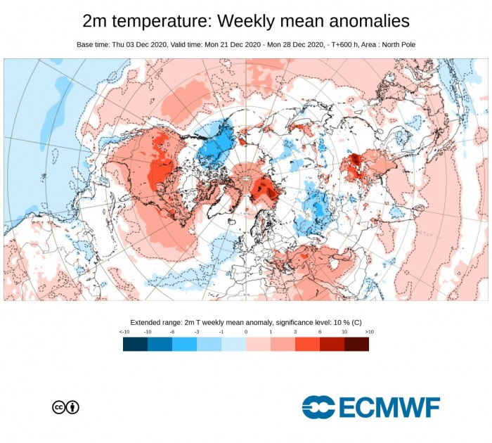
The December weather pattern in week 4 is also very similar in the ECMWF. We have the La Nina grip over North America and the continuation of the same pattern over Europe. But the ECMWF is much better defined over Europe, showing the low-pressure area over the western parts, but situated more towards the south, which is not very supportive for winter weather in central Europe.
The temperature forecast shows this, as the colder air is more further out in the Atlantic, while central and southeastern Europe remain mostly warmer than normal. But a small change in the positioning of the low-pressure system in the west can make a big difference for the weather in western and central Europe.
Over North America, we see the La Nina grip, with colder air more closed off into western Canada and the northwestern United States. This essentially means a pause in winter weather for the southern and southeastern United States for the time being.
DECEMBER WEATHER AND THE POLAR VORTEX
One aspect of the December weather development is the stratospheric polar vortex. A lot has been already written about the Polar Vortex and its winter influence.
Essentially, the polar vortex is a large area of cyclonic circulation high above the Northern Hemisphere. It extends all the way from the ground, up into the stratosphere, over 40km altitude.
We tend to look at the stratospheric polar vortex and its development because when it is strong, it can also influence the lower layers of the atmosphere and our weather. Usually, a strong polar vortex corresponds to lower pressure in the North Atlantic and over the North Pole. That can mean a stronger jet stream and the cold air tends to be locked into the polar region. So a strong polar vortex is not what one wants to see if you hope for a colder and snowier winter over Europe and the United States.
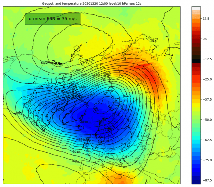
Current forecasts show a strong polar vortex, but as seen in the image below, the late December forecasts are hinting at a possible weakening of the Polar vortex. We can see a temperature wave developing over the Asian secotr. If persistent, strong dynamics can lead to further temperature waves, and eventually a strong pulse of warming can result in a Sudden Stratospheric Warming event. That means a disruption of the polar vortex and can have a major influence on our weather. The graphic is by weatheriscool.com.
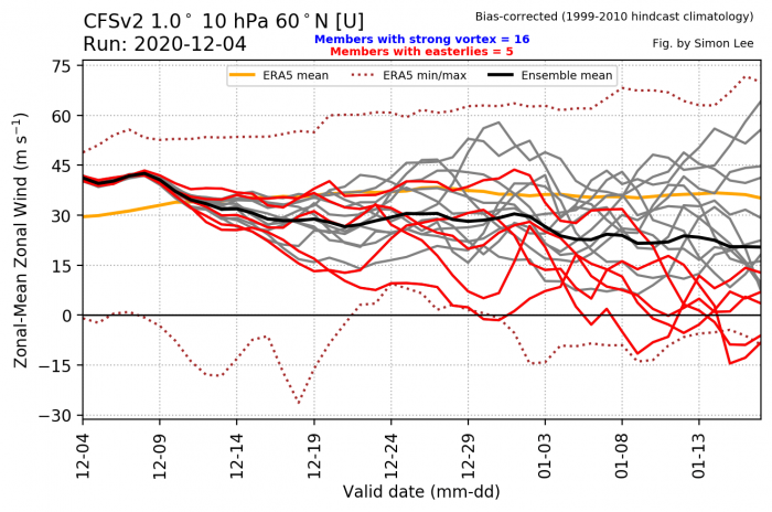
The most common way to estimate the strength of the stratospheric polar vortex is to look at the wind speeds it produces. We usually look at the strength of the stratospheric jet stream at 10mb level (~30km altitude) in the middle stratosphere.
The image below is from the excellent polar vortex page by Simon Lee, and shows the average strength of the westerly winds at that level, around the polar circle (60°N latitude).
We can see the stratospheric winds, which are running above the long term average currently, but they are trending down. This implies a gradual weakening of the polar vortex, with some individual calculations even showing a major Stratospheric Warming event unfolding in early January. Such forecasts are usually not very reliable at long ranges, but it is a reminder that we have to monitor the situation closely, as something important could be developing.
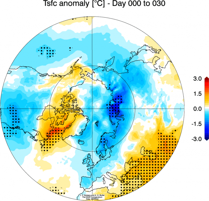
Essentially, an SSW event (Sudden Stratospheric Warming), can have a major impact on the circulation and can cause major pattern changes in the Northern Hemisphere. So a potential SSW event is an important factor that can change the course of winter in either way across the North Hemisphere. Below is an image that shows an average temperature pattern after a stratospheric warming event, blocking the Arctic regions, and releasing cold air into the mid-latitudes.
Not all SSW’s produce cold air outbreaks in Europe and the United States, so we must take an individual approach every year, as each year is a special case on its own.
We will produce a separate (and more detailed) article on the activity in the stratosphere, and what it might mean for the rest of winter in January and February, so stay tuned!
ALSO DONT MISS:
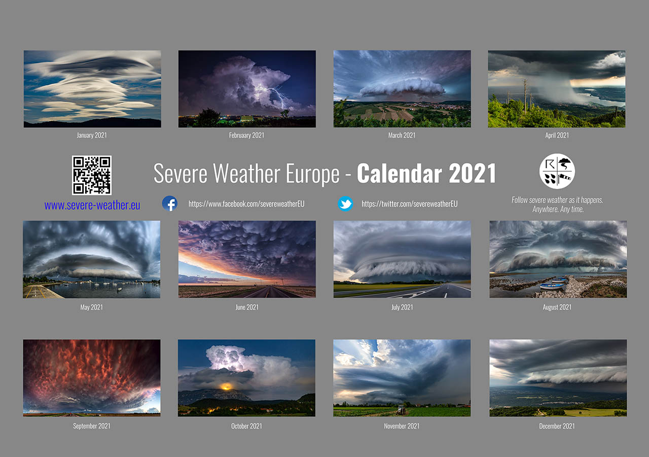
Thinking of a nice Christmas gift for your friends, family, or someone special to you? Weather calendar could be the perfect gift for them – see below:
