Potentially a very dynamic weather pattern change is shaping up for central Europe in the coming days, as a very deep trough will dominate the continent. Deep surface low forms over western Europe, with a secondary low in the northern Mediterranean. And the result is an extremely dangerous winter weather setup across the southern Alpine flank. There, an extreme amount of snow is expected over the next few days – up to 4 meters of fresh snow is increasingly likely and could lead to catastrophic avalanches.
The general picture over the North Atlantic and Europe has changed as we entered the much more dynamic weather pattern lately. An extensive and strong upper-level ridge has developed over the North Atlantic, blocking the westerly zonal flow towards the European continent.
A more northerly, meridional flow will allow an extremely cold, Arctic air mass to push towards western Europe and result in a very deep trough in the coming days, with a deep surface depression centered over the UK. The trough will dig far south and dominated a large part of Europe.
As both expand and spread towards the Mediterranean, a secondary surface low develops over Italy and establishes a textbook excessive rainfall/snowfall event for the north Mediterranean region. According to the latest model guidance, an extreme, potentially catastrophic amount of rain and especially snow could develop across the southern Alpine flank.
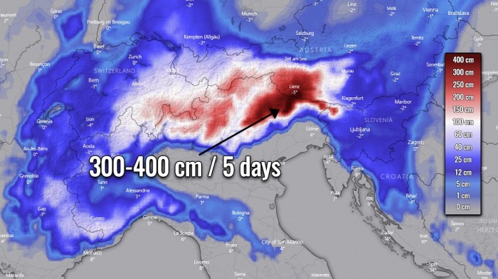
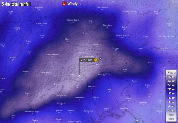
Weather models are hinting that 500-700 mm (20-27 inches) of accumulated precipitation will be possible across the northeast Italian and southern Austrian mountainous terrain. Indeed as heavy snow over the higher elevations, therefore even more than 400 cm (4 meters or 13 feet) of fresh snow could accumulate until Monday.
These amounts of rain and snow hint at a *HIGH RISK* for flooding and especially an extremely dangerous avalanche risk for the region.
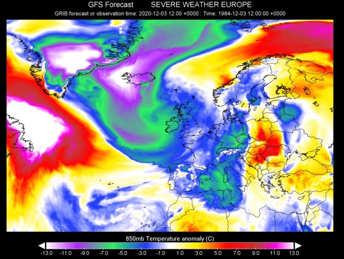
Here is an impressive animation of the 850 mbar temperature (approximately 1500 meters above sea-level) anomaly over Europe and the North Atlantic in the coming days. We can perfectly see a very cold air spreads deep far south into southwestern Europe and the Mediterranean.
To the east of the large depression, strong warm advection spreads over eastern Europe and northwestern Russia.
A VERY DEEP TROUGH ESTABLISHES OVER EUROPE
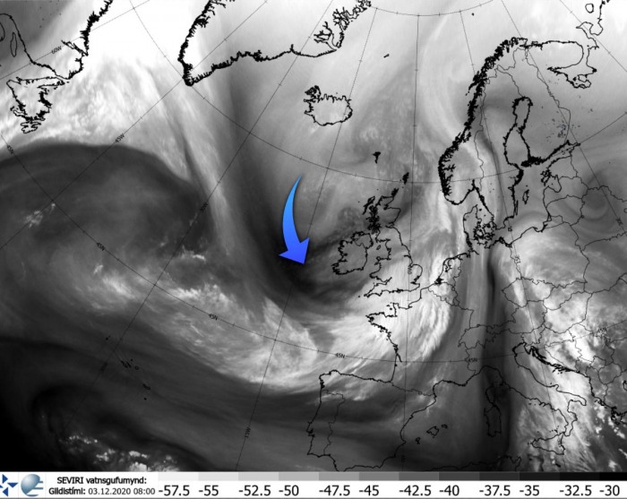
A rapidly changing weather pattern over Europe is underway today, Thursday, December 3rd. A very strong upper-level ridge and an associated surface high-pressure system are dominating the North Atlantic, while a deep Arctic trough is emerging south along its eastern flank.
As it can be seen from the water vapor image below, dark colors represent a rather impressive intrusion of Arctic cold and drier air mass towards western Europe, while a surface depression is underway between Iceland and the UK.
The trough will continue moving south over the next two days and significantly strengthen on Friday. It will be a dominant feature for the European continent until next week.
Thursday, Dec 3rd
As said, the pattern over Europe is rapidly changing today. A deep trough is establishing into the western by Thursday afternoon, with a short-wave trough visible over the Mediterranean. That is the snowstorm and ice storm event which was ongoing since Wednesday across the Alps and northwest Balkan peninsula.
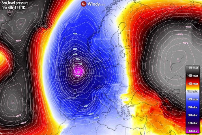
At the same time, a strengthening surface depression is underway, centered near the Faroe Islands and gradually expanding southeast into western Europe. The central pressure should reach close to 980 mbar by Thursday evening in its center. While we can see a strong high-pressure system over the Azores, and a powerful high over Russia.
The strengthening pressure gradient between North Atlantic and western Europe is also resulting in an intensifying cold advection from the Arctic region towards the deep trough. Spreading across Iceland and further south towards the UK as well.
Very high-temperature anomalies are observed across eastern Canada and the Labrador Sea, resulting from the advection of very warm air mass on the rear side of the blocking high.
Friday, Dec 4th
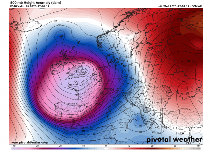
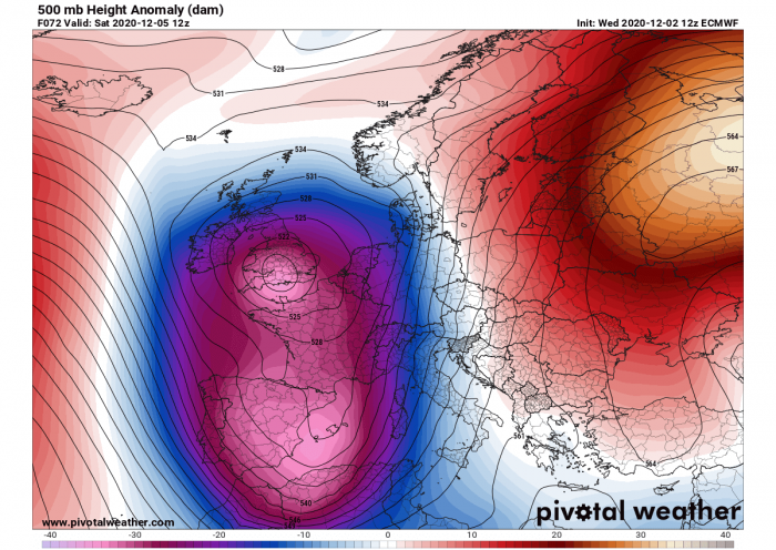
By tomorrow, Friday, the upper trough literally explodes and becomes very strong! As we can see from the 500 mbar geopotential heights chart below, the core will be very deep. And the trough itself will be expanding, centered over southern England, northern France and the Bay of Biscay.
Normally, the surface pressure is also responding to the strengthening/deepening of the upper low, so the surface low is expected to deepen below 970 mbar while crossing the UK. Models hint that its center will be over southeast England by Friday afternoon when also its peak is likely to occur.
As we can see, the deep and large low is trapped between both upper ridges and high-pressure systems to its west and east, an ideal setup for the development of such a surface low into a large part of Europe.
The significant cold advection on the rear side of the trough will continue towards the south, reaching the Iberian peninsula on Friday. Extreme anomalies will remain over Iceland with a strengthening surface high-pressure system towards Iceland. A very strong pressure gradient will develop against the west European low.
The air mass ahead of the large trough will also warm up across the eastern half of Europe, as the strengthening of the south-southwesterly jet stream will be underway from the Mediterranean and the Balkan peninsula northwards.
Saturday, Dec 5th
While the trough peaks on Friday, it remains very deep also on Saturday. And continues expanding south, as barely anything can stop its southward progress as a strong ridge is placed to its west.
The trough splits into two cores, where one remains over the UK and the southern one pushes further south into the Iberian peninsula and the western Mediterranean. A very strong ridge persists over Russia.
Typically this means that the warmer Mediterranean region gets a secondary low due to the advection of significantly colder air mass aloft. The surface low forms over the northwest Mediterranean by Saturday morning, gradually drifting northeast while gaining strength and deepening through Saturday night.
Both the upper core of the deep trough over the Iberian peninsula and the developing secondary surface low over the western Mediterranean will help the cold advection on the western side of the main trough to continue further south-southeast, reaching Morocco and Algeria as well. Very cold weather will spread over Spain and Portugal.
The advection of much warmer air mass continues to the east of the trough, spreading across the Balkan peninsula, eastern Europe, and the Baltic region. The warm air mass will result in the rapid melting of the accumulated snow over the northern Balkan peninsula this week.
Sunday, Dec 6th
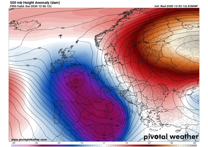
Towards Sunday, a large and deep trough cuts off over the Mediterranean. While it is gradually losing its strength, it remains deep and slowing down. The powerful ridge over Russia maintains its position, so further eastward progress of the trough is not expected.
The trough will remain over the Mediterranean and gradually diminishing into early next week.
In response to a very powerful ridge over Russia, and associated surface high-pressure system strengthens there, nearly 1050 mbar will be in its center, to the north of the Caspian Sea. While a large surface depression/low over western Europe is weakening over the weekend, but the secondary low over the Mediterranean additionally strengthens on Sunday.
A Genoa low develops over the Ligurian Sea and drifts across northern Italy.
As the trough is weakening, the cold advection is also losing its strength on Sunday. It remains colder than average across the west, southwest Europe and the western Mediterranean, but not significantly cold anymore. Colder weather will also be the effect of a large pool of cool maritime air mass overspread across the region from the previous days.
The warm advection over the Balkans, Eastern Europe, the Baltic region, and northwest Russia keeps strengthening, becoming quite extreme with more than 10-12 °C warmer air mass than normal for early December.
SOME SNOW OVER THE UK
First, some decent amount of snow is possible for parts of England and Scotland on both Thursday and Friday, as much colder air mass spreads over the region. Some winter precipitation is forecast under the large, strengthening surface low.
Although the amount of snow should not be particularly high, 10-20 cm of fresh snow could locally accumulate by Saturday morning.
WINDS AND MAJOR WAVES OVER THE ATLANTIC
A broad channel of severe winds will establish between both large scale features, a strong pressure gradient will be in place between the North Atlantic ridge/high-pressure system and the deep trough/surface low over western Europe. Those will be extending in a wide channel from west of Iceland to the western UK and Ireland on the eastern side.
And the areas affected will be broad, from Iceland to Ireland and further south into western France, Spain, and Portugal. Peak gusts will locally reach 90-120 km/h.
Persistent strong to severe winds for almost three days will indeed also generate significant waves over the Atlantic. Those will be the highest between Iceland and the Faroe Islands on Friday, as the strongest winds and pressure gradient develop here. More than 12 meters high waves will develop.
Major waves will also be spreading further south through Saturday, reaching western Ireland on Friday night and then Spain and France over the weekend.
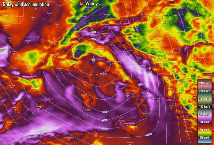
When the main deep trough develops a secondary low over the Mediterranean, it will indeed increase the wind field there as well. Very strong southerly winds will establish across the Adriatic sea on Saturday and Sunday, pumping warm and very humid air mass towards the Alps.
Strong winds are also likely across the southwestern Mediterranean, on the rear side of the secondary low as a stronger pressure gradient will develop against the strengthening high-pressure over the Azores.
ALPS AHEAD FOR 300-400 CM OF SNOW UNTIL MONDAY
What is likely the main and the most dangerous part of this pattern, is the potentially catastrophic outcome with tons of snow over the Alps. The forecasted amounts of snow are so extreme in a relatively short period of time, that a *HIGH RISK* for avalanches is expected for the weekend into early next week.
As we have discussed earlier, a rather classic pattern evolution is expected over Europe, this means a deep large upper-level trough and deep low over western Europe with a secondary surface low forming over the northern Mediterranean. A textbook so-called ‘Genoa low’ cyclogenesis is forecast to take place on Saturday and Sunday.
This normally means that conditions are rapidly worsening over the Alps, as both the warm advection from the Mediterranean and the wind field are increasing. In other words, this means intensifying orographic rainfall or snowfall for the northern Mediterranean region.
And what is shaping up regarding the amount of precipitation this weekend, is a real concern.
Attached below is the general picture for precipitation sums over the next 5 days, so from Thursday until Monday. We can see a tremendous amount of precipitation is forecast for the southern Alpine flank, nearly 500-700 mm is forecast by the weather models. A lot of rain is also forecast for the northern Apennines.
It has to be noted that the majority of this comes from Saturday afternoon until Sunday evening, as most of the precipitation will be associated with the deep secondary surface low over northern Italy over the weekend. So the amount of rain will be roughly a short 48-hour event!
Here is a closer look over northeast Italy where the maximum is likely to occur. ICON-EU model hints even more than 700 mm! Such an amount could become a serious flooding threat for the lowlands along the slopes, depending on how high the snowfall will be occurring.
And now to likely the most extreme and dangerous part of the event, the EXTREME amount of snow. The overall temperature for the weekend hints that very intense snowfall will be occurring over the Alps, especially from Saturday mid-afternoon until the evening on Sunday.
According to the precipitation forecast above, the amount of snow will be beyond exceptional.
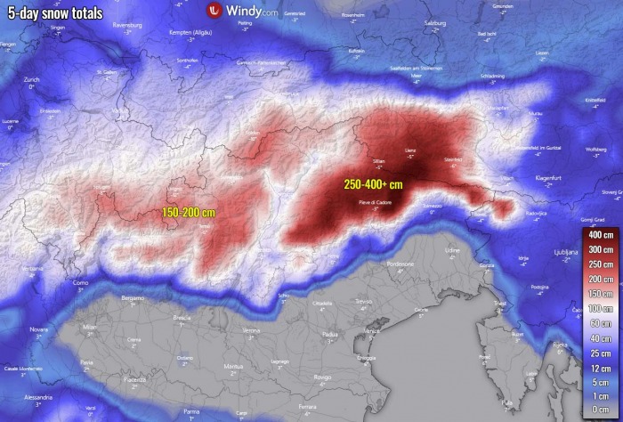
Both global, the GFS and ECMWF, and also the high-resolution ICON-EU weather models are forecasting a very high amount of snow. About 400+ cm (13 feet) of fresh snow is forecast where the peak of the precipitation is expected, over northeast Italy into southern Austria. 150-200 cm is also forecasted further west over the western Alps.
Here is a closer look over the region where peak snow amount is forecast. The ICON-EU model actually hints at the potential for more than 500 cm of snow over the next 5 days. Yes, 5 meters of snow! And keep in mind, that the majority of it will fall over a period of 36-48 hours from Saturday afternoon until Sunday evening.
Such potential for more than 500 mm of precipitation and also 400 cm (4 meters or 13 feet) of fresh snow accumulating until Sunday evening introduces *HIGH RISK* for flooding and especially an extremely dangerous avalanche risk for the region.
The impact to the slopes and some Alpine valleys in the most-affected areas could be catastrophic.
HURRICANE-FORCE WINDS AND EXTREME COLD OVER ICELAND
With the progress of the strengthening trough further south, a surface depression between Iceland and the UK is deepening. This is already resulting in a tightening of the pressure gradient across Iceland on Thursday. Leading to extremely severe, hurricane-force winds across the southern portions of the country.
According to the high-resolution weather models, attached below is the ICON-EU model, the peak gusts could well exceed 200 km/h, as seen on the chart below.
The most violent winds are expected along with the south-southeast parts of Iceland where the complex terrain creates channeling of the downslope winds from the glaciers. And those extreme winds are also spreading into the coastal populated areas.
A combination of both, very cold temperatures further inland and the pressure gradient results in extreme conditions. Those should introduce very difficult travel and life-threatening conditions across southeast Iceland. The official warning calls for peak gusts in excess of 160 km/h (= 45 m/s).
As noted by the Icelandic Met Office:
South East
North and northwest severe gale or storm (Orange condition)
2 Dec. at 19:00 – 4 Dec. at 13:00
Becoming north and northwest 20-28 m/s by eastern Vatnajökull and in Öræfi. Also expected north 20-25 m/s in the Myrdalur area. Gusts expected to exceed 45 m/s with possible sandstorms and flying pebbles. People are advised to secure their neighborhoods and show caution. Dangerous travel conditions.
Another thing to notice is a rather impressive, extremely cold weather developing across the far northern North Atlantic, including Iceland. The advection of Arctic cold air mass is forecast to be very intense over the area. A much colder air mass advection is already underway on Thursday and will continue until the weekend.
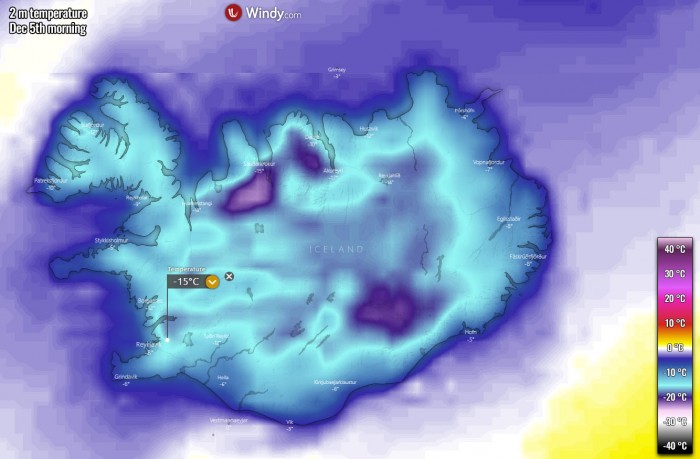
Both Friday and Saturday will be significantly colder than normal for Iceland, roughly 10-15 °C below the long-term average for early December. This will establish extremely cold temperatures across the whole country.
While the winds will be gradually weakening on Friday, as a higher pressure emerges from the west. This should allow the morning temperatures to be the lowest on Saturday. Therefore, the most extreme values are likely to be experienced on this day.
Potentially -15 to -20 °C in many areas, including the capital Reykjavík. Indeed even lower in higher elevations, over the glaciers.
And to make it even more extreme, strong to violent northerly winds will bring the wind chill temperatures even lower. Closer to 40-45 °C below zero will be the real feal of the temperatures through Friday and Saturday in places.
CONCLUSION
With the more dynamic pattern across the North Atlantic and Europe lately, potentially very dangerous weather pattern change is shaping up for central Europe in the coming days. An extensive and strong upper-level ridge has developed over the North Atlantic, blocking the westerly zonal flow towards the European continent.
As a result, a very deep trough will dominate the continent and bring a deep surface cyclone into western Europe and its secondary low in the northern Mediterranean.
This will introduce an extremely dangerous winter weather setup across the southern Alpine flank. There, an extreme amount of snow is expected over the next few days – up to 4 meters of fresh snow is increasingly likely and could lead to catastrophic avalanches on Sunday and Monday!
We are closely monitoring the event evolution and will keep you updated until the weekend – stay tuned!
Don’t miss a chance for a nice gift for your friends, family or someone special… Weather calendar could be the perfect gift for them – see below:
