At least 50 twisters were reported during the historic tornado outbreak this weekend, with numerous fatalities in Kentucky, Arkansas, Illinois, Missouri, and Tennessee. Hundreds of buildings collapsed, millions are still without power. The weather pattern is now changing into a powerful blocking High to the East, forecast to deliver a record-breaking heatwave through the mid-this week. To the West, another winter storm will blast across the Rockies into the Midwest and the Great Lakes with snow to the north and very windy conditions across the central United States.
Sadly, the death toll with the tornado outbreak is likely to exceed 100 as rescuers comb tornado wreckage and people are still missing. Twisters have killed more than 80 people in Kentucky alone, with the worst destruction in the town of Mayfield.
The confirmed deaths so far are standing at 94 in total. 6 people were killed in Illinois, 4 in Tennessee, 2 in Arkansas, and 1 in Missouri. The 6 people in Illinois died during the partial collapse of a local Amazon warehouse, according to Edwardsville police.
HISTORIC TORNADO OUTBREAK HIT ARKANSAS, MISSOURI, TENNESSEE AND KENTUCKY
A nighttime tornado outbreak devastated portions of the east-central U.S. Friday night, lasting for approximately 11 hours. Leaving 50 tornado reports. Out of those 50, 23 tornado paths have already been surveyed, resulting in 5 EF3, 8 EF2, 7 EF1, and 3 EF0 tornadoes. The damage survey along the paths of the strongest tornadoes is still underway and could take days to finish as the wreckage is catastrophic.

As we can see from the attached composite radar image above, the Quad-State storm was a cyclic tornadic supercell initiating SW of Little Rock, AR, and intensifying while moving into the NE Arkansas, then SE Missouri, and across NW Tennessee into Kentucky. The supercell had a total lifetime of more than 11 hours, spawning several tornadoes along its 600-mile path.
One of the deadliest tornadoes spawned from this tornadic supercell had an approximate 227-mile-long path of destruction. The tornado traveled across four states, grazing about 200 of these miles in Kentucky alone. It has started in northeast Arkansas, crossing extreme southeast Missouri, and continued into northwest Tennessee before emerging into Kentucky and wreak havoc across several towns.
The NOAA scientists are in the field doing damage surveys along the tornado track. According to the preliminary data, the event may have spawned one of the longest-track tornadoes in U.S. history. Possibly beating the infamous Tri-state tornado outbreak from March 18th, 1925 which traveled 219 miles (352 km) in about 3.5 hours of its lifetime. The Tri-State Tornado grazed through Missouri, Illinois, and Indiana leaving nearly 700 people dead, and remains the longest-track tornado on record.
Below is an overview of the December 10th historic tornado outbreak across parts of the United States. Tens of tornado warnings have been issued across the affected states, with twisters reported by red triangles. Notice how long the tracks are, as tornado warnings extend along them from Arkansas and Missouri towards east-northeast, ending in Illinois, Kentucky, and Tennessee.

This severe weather event was very well forecasted by the Storm Prediction Center (SPC) with their precise convective outlooks in the last 48-hour period before it happened.
Cold weather has swept across the nation after the event, posing an additional danger to the people affected. Thankfully, the general weather picture is now changing as much warmer temperatures are in sight in the following days.
POWERFUL HIGH ESTABLISHES, BRINGS STABLE AND EXTREMELY WARM WEATHER FOR MANY THIS WEEK
After the major winter storm bringing severe weather havoc across the Ohio Valley and a swath of significant snow over the Upper Midwest, the weather pattern is now hinting at a potentially record-breaking heatwave for the central United States. The unseasonable warmth will develop from Texas in the south to Minnesota in the north, and to the east across the Mississippi Valley to Ohio Valley. As well as also farther north into southern Canada.
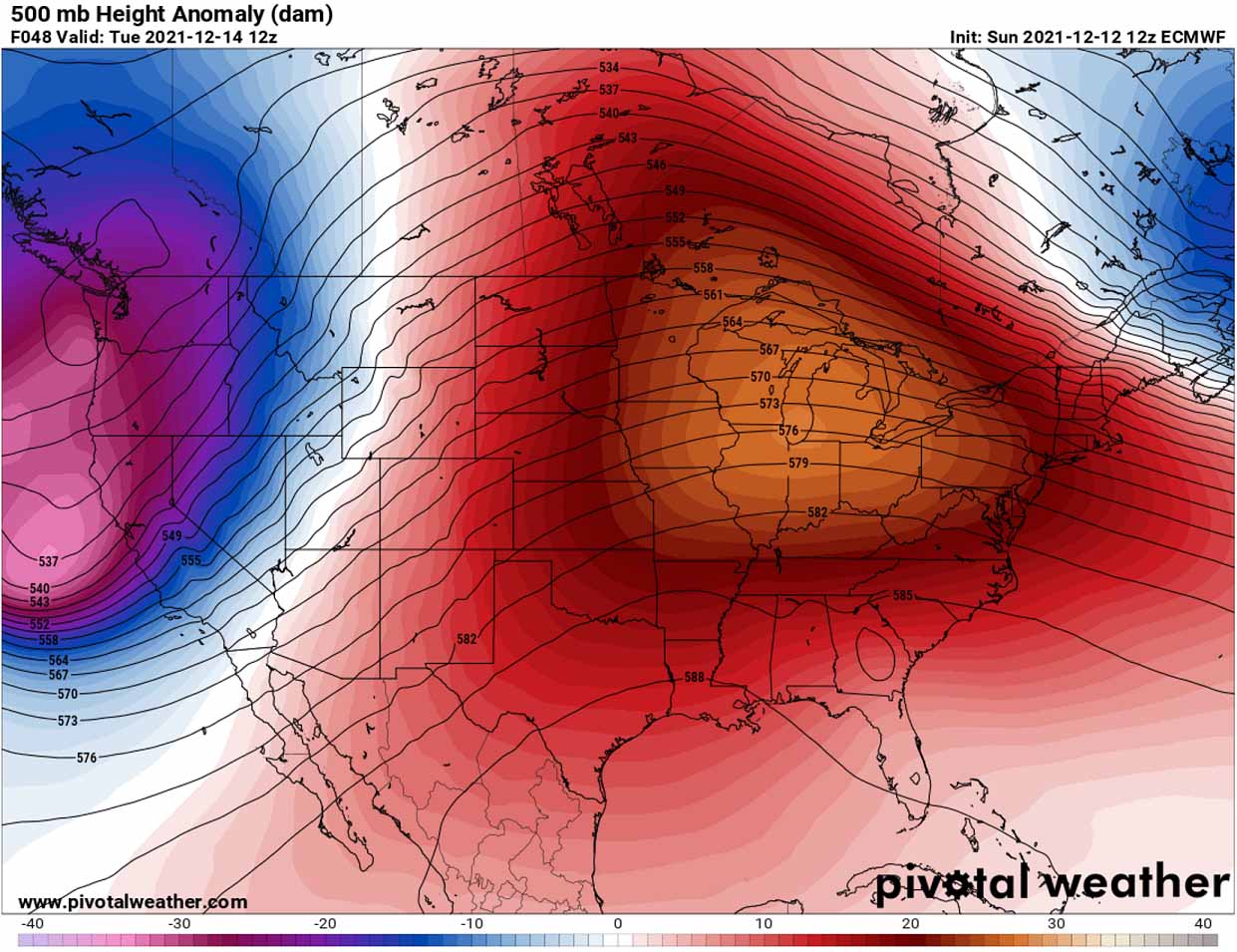
Thanks to the weather pattern change with a powerful blocking High developing across the eastern U.S. and the deep trough emerging into the West Coast, significant warmth follows. A textbook dipole pattern will establish for several days before another winter storm blasts across the Rockies into the Midwest and the Great Lakes.
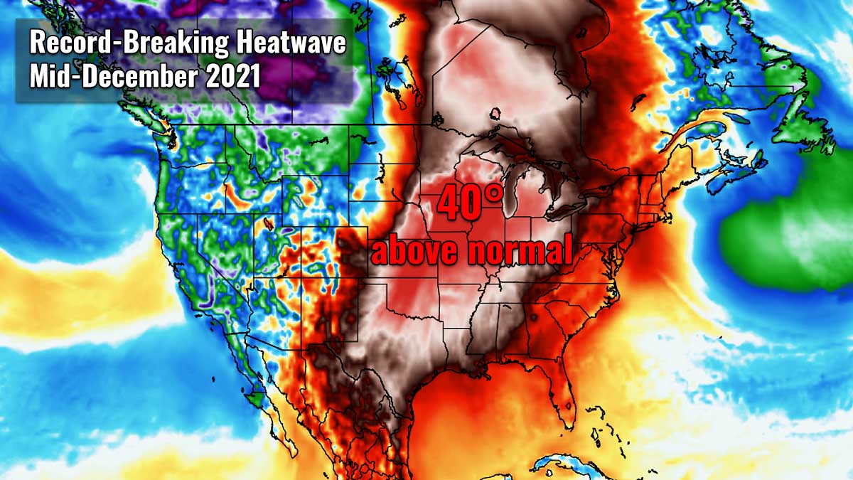
An unseasonably warm period will develop under the ridge, resulting in more than welcome relief after the destructive tornadoes over the weekend. The temperature will be extremely warm, even more than 40 °F above normal for mid-December across several states.
It will feel more like the early fall season is back as the temperatures more typical of September or early October are forecast.
The upcoming winter heatwave will be even more intense than the recent warmth across the central U.S. last week, likely challenging and setting many daily high temperatures. Note that the National Weather Service defines a heatwave as a period of very warm weather lasting for at least two days.

We can surely remember hearing the term heat dome quite often last summer, right? It was the dominant feature of summer 2021 in both continents, North America and Europe, resulting in deadly heatwaves and wildfires. It is the term to blame and remember from this wild weather year, and here is why.
HEAT DOME OFTEN BRINGS INTENSE HEATWAVE, EVEN IN WINTER SEASON
Under the upper-level ridge, known as the blocking High pattern, a so-called heat dome forms quite often. Such kind of weather pattern brings very high, sometimes record-challenging temperatures for the region underneath, no matter the season. A heat dome is a term that we typically use when a large area of high-pressure parks over a large portion of the continent and stays there for several days or even weeks (most often in summer but even in winter).

The most simple explanation of the heat dome term is that it works like a lid on a pot. The large dome is trapping a significantly warmer air mass at all levels underneath, becoming extreme especially at the lowest elevations. Thus creating stable weather and often also very dry air mass with minimal chances for precipitation, or even clouds. This is thanks to sinking air parcels in the center of the heat dome, allowing air mass to warm up a lot.
The daily maximum and average temperatures are normally well above average under the heat dome, and often challenge or even break the existing heat records. This is exactly what is about to happen this week, with a strong dome expected to form under the powerful upper High.
Note, that heat dome is often also to blame for being responsible for deadly heatwaves around the world.
EXTREMELY HIGH TEMPERATURES COULD SMASH ALL-TIME HEAT RECORDS
St. Louis (MO) tied its all-time highest temperature for December on the 3rd, ending at 76 °F, breaking the 70+-year-old record. The extreme warmth upcoming in the following days could smash the heat record once again as central Missouri might end up into the mid to upper 70s pretty easily again.
Chicago could peak into the mid to upper 60s on Wednesday, with temperatures into the low 70s across the southern and western portions of Illinois. Easily breaking its daily temperatures for Dec 15th.
Actually, the warm spell will be so intense towards the north, Chicago might be challenging its all-time December’s heat record of 71 °F, set back on Dec 2nd, 1981. The large city often battles with the cool breeze from Lake Michigan, but with strong enough southwesterly winds, temperatures could break above the 70 °F mark on Wednesday.

Temperatures are expected to climb much higher also in the areas that were buried by rather deep snow recently, precisely over the northern Plains and Upper Midwest. The significant warmth will cause snow to melt away quite fast as days will warm up into the mid-60s to upper 70s in places through Wednesday.
Nebraska, Iowa, Minnesota, and Wisconsin are about to experience temperatures in the 60s. These states are forecast to receive temperatures so high that have never been recorded before in December, including Des Moines (IA) or Omaha (NE) where temperatures will hit the mid-70s through mid this week, setting all-time records if the temperature forecast verifies. Similar record-challenging temperatures are also likely in Kansas City (MO) on Wednesday.

The above 2m temperature anomaly for Wednesday is beyond exceptional. Temperatures across Oklahoma, Kansas, Missouri, parts of Nebraska, Iowa, Illinois, southern Minnesota, and southern Wisconsin will be 30 to more than 35 °F above normal. That’s really extreme and that is why we are about to challenge those heat records quite likely.
Thursday will be even warmer from Missouri to Illinois and Wisconsin, with temperature anomalies even higher than a day before. If those nearly 40 °F are above normal verify, all-time records will be easily shattered. Notice how extreme warmth also spreads into southern Canada on both days, 25 to more than 30 °F above normal is forecast. It will be much warmer also across the South, with up to mid-80s in Texas well possible.
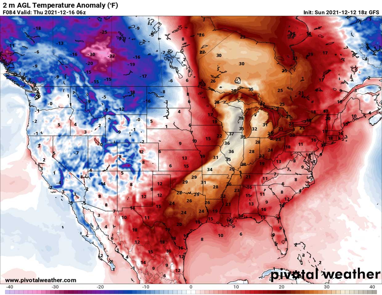
While the majority of the intense heatwave will spread across the central U.S., the warmth will also expand towards the east. The second part of the week could push high daytime temperatures also towards the East Coast and the Northeast U.S. Temperature might climb into the mid to upper 60s, possibly even low 70s towards the next weekend.
The East Coast has already experienced some significant warmth this past weekend, breaking its old daily records in New York, Washington D.C., and Philadelphia.
THE NEXT WINTER STORM WILL BRING A SIGNIFICANT WINDS AND MORE STORMS FOR THE SOUTHEAST
The powerful upper ridge (High) will not be lasting more than just a few days, however. As the progressive weather pattern across North America is nowhere to its end this month. The deep low which will emerge into the West Coast through early days this week will dig farther east into the Contiguous U.S., developing yet another significant winter storm. The chart below is showing how the ridge gets replaced by the trough once again.

After Wednesday, the heat dome and the parent upper High gradually move and expand into the Northeast U.S. and eastern Canada, pushing temperatures higher there as well. We can also see how a strong ridge also develops over the northern Pacific, it will help to push colder air mass with the emerging West Coast trough into the western CONUS.
The progress of the trough across the Rockies results in the development of a secondary low, surface depression along the eastern portion of the mountain chain by Tuesday night, intensifying into Wednesday while gradually expanding towards the Great Plains.

The pressure in this surface low will considerably deepen, about 12-15 mbar while the center moves towards the Upper Midwest Wednesday night. Now take into account how strong the upper High will be in place to the east, this calls for a pretty intense jet stream in between these two large-scale features. These winds will also translate into the lower levels, therefore affecting the Plains as well.
The pressure energy will create a swath of particularly strong winds ejecting off the eastern Rockies into the Great Plains. The winds are forecast to first intensify over the High Plains, spreading into the Central Plains throughout the day on Wednesday while the low tracks to the northeast. Damaging winds will be possible from the southern Rockies to Upper Midwest, extending across more than a 1000-mile swath (from New Mexico to Iowa and farther northeast) across the central parts of the country.
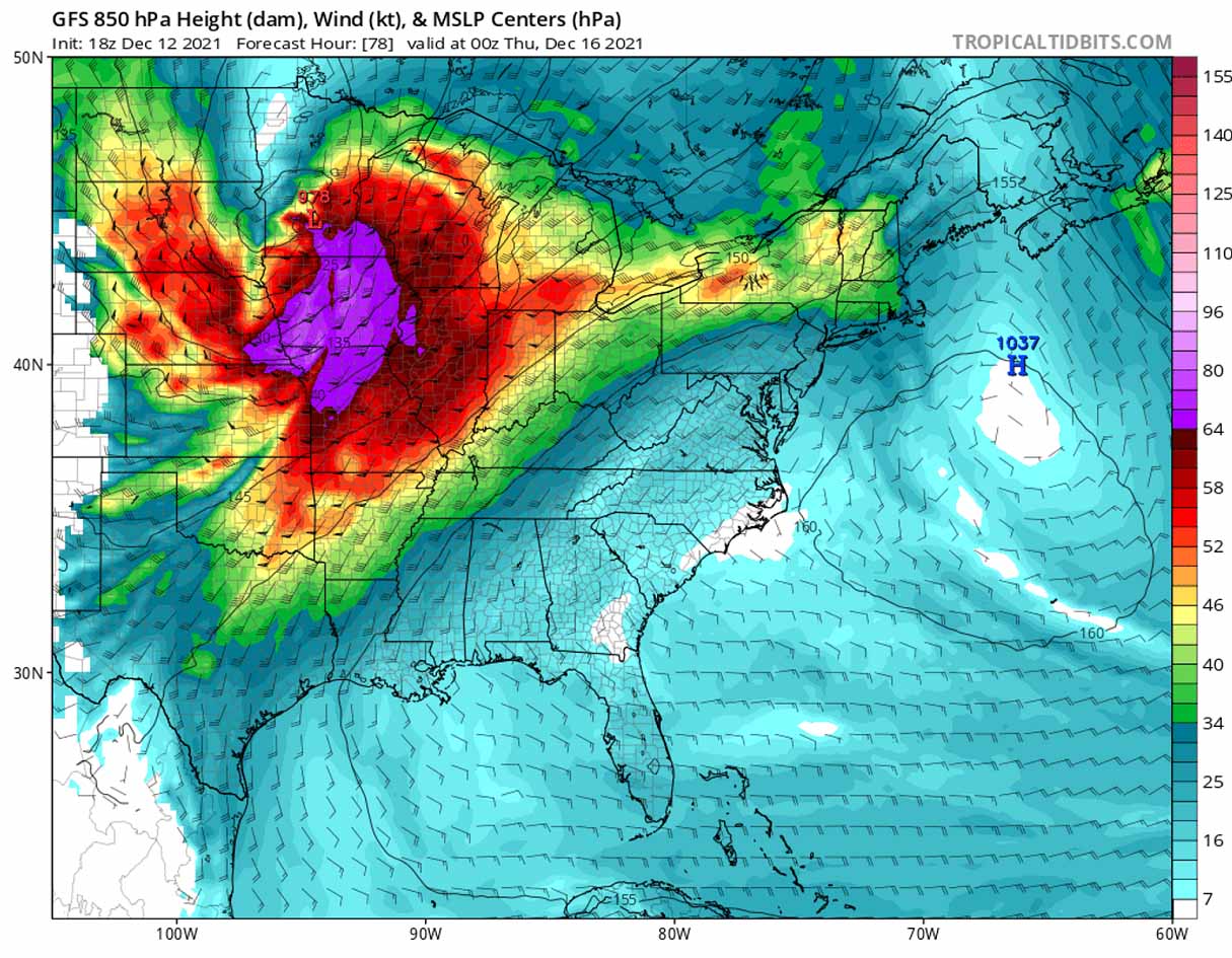
Winds will be gusting 50-70 mph in many areas, including the city of Chicago on late Wednesday, soon after the heatwave will peak across the region. Gusts could damage trees and may lead to some power outages as well. When winds are this strong, it leads to the highest danger for the high-profile vehicles traveling across the Plains, the risk for roll-overs will be high.
The most intense gusts will likely develop as downslope flow along the Front Range of the Rockies in Colorado, as the winds accelerate down the slopes towards the Plains. Those could easily exceed 100 mph!
Once the low moves across the Upper Midwest towards southern Canada by Thursday, gusty winds will also translate even farther east and spread across the Great Lakes, reaching Indianapolis and Detroit as well. Strong gusty winds will also spread across southern Ontario as low continues deepening as it moves into Canada through Thursday.

The cold front associated with this low will also bring some additional storms, possibly also severe, extending from eastern Texas to Mississippi and Ohio Valley on late Thursday. While the lack of a more robust thunderstorm environment is in place, severe winds might cause some additional damage over the areas that were badly hit on Friday night.
The front will be gradually moving east-southeast overnight to Friday with stormy weather and heavy rain across the Southeast U.S.
INTENSE WINTER STORM BRINGS A LOT OF SNOW FOR THE ROCKIES
The newly developing winter storm moving from the West Coast across the Rockies will result in significant snowfall. First, intense and excessive snowfall will blast across Nevada, Utah, and northern Arizona on Tuesday through Wednesday morning, with a forecasted *huge* amount of snow across the mountain tops. Snow heights will be counted in several feet.
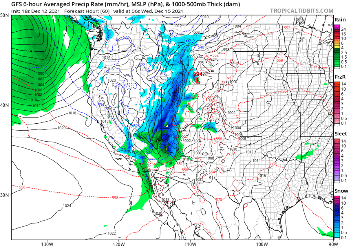
Then, with the winter storm and surface low intensifying through Wednesday, the heaviest snowfall translates into Colorado and Wyoming, partly also into northern New Mexico. Intense snowfall will develop along the leading cold front, with blizzard and whiteout conditions expected.
Farther northeast, the winter storm will also have the potential to bring a swath of new snow across parts of the Upper Midwest and northern Plains from Wednesday night into Thursday. But according to the recent forecast models, the amounts should not be too significant off the Rockies.
This is mainly because the low will be so particularly intense, that moisture conditions will be lacking beneath the powerful southwesterly jet stream this time. So the intense pressure difference will translate more into the event of the severe wind across the Plains and the Midwest.
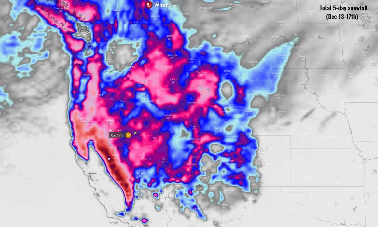
But the intense wind field associated with this storm will result in the highest amount of accumulating snow across the Rockies, precisely across the mountain ranges where orographic features will be the most intense. This certainly applies to the Sierra Nevada mountains, as we could notice from the chart above.
Those snow amounts forecast over the next 5 days there are utterly impressive. More than 85 inches or 7 feet (200 cm) of fresh snow will be possible. Conditions will rapidly become extremely dangerous for avalanches there as well.
Our thoughts are with the people affected by the recent storm. Stay safe!
*******
Images used in this article were provided by Wxcharts, Windy, and Tropical Tidbits.
SEE ALSO – these days, the peak of the Geminid Meteor Shower occurs. Grab a chance and enjoy the spectacular celestial show.