September 2021 over Europe was a pretty dynamic month, bringing two events of a much colder air mass into eastern parts of the continent. This week, a large North Atlantic depression has developed, gradually spreading a large cold pool towards western Europe. The associated surface low considerably deepens on Tuesday and develops a massive snow blizzard across northern Iceland.
Through the early and mid-September, two quite significant cold outbreaks developed over Europe, then the cold intrusions vanished. The month started with a strong Arctic cold blast into Scandinavia and the Baltic region. While the other cold outbreak hit the Balkan peninsula, southeast Europe and Turkey last week.
Since then, the weather across Europe has settled down a bit, with no significant cold or warm periods. It has been dynamic, but with only some normal autumn temperature fluctuations, including some snow in the Alps, higher elevations of the Balkan peninsula and Turkey. But at least western Europe and the North Atlantic are impacted by more cold now.
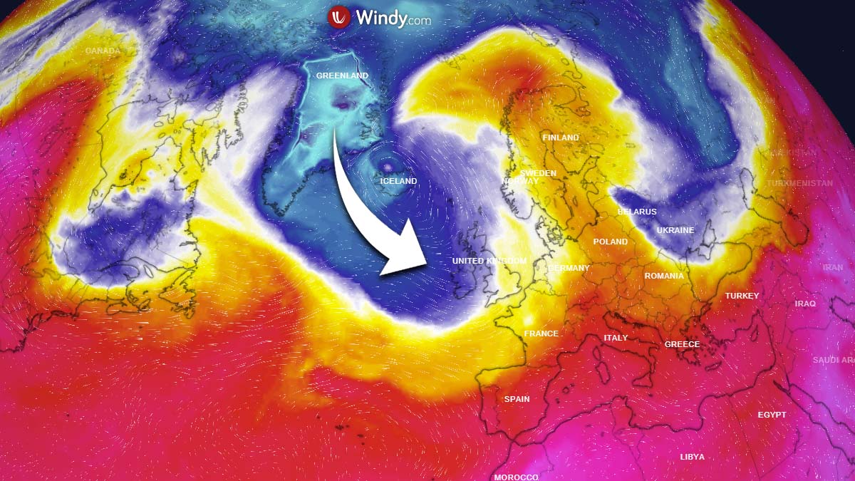
This Monday, the visible channel of the satellite image indicates a textbook advection of a cold maritime air mass spreading in the wake of a large North Atlantic depression. Gradually moving into Ireland and the southern UK, intensifying tonight.
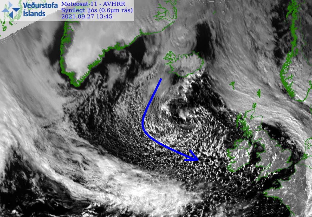
We can also clearly see the center of this large low, centered to the south of Iceland. The arrival of a much colder air mass tonight will result in a secondary low ejecting off the northeast UK and the North Sea towards the north.
Here is an animation of the cold pool developing over the North Atlantic, spreading into western Europe over the next three days. Notice how the secondary surface low is responsible for this dynamic in the weather pattern across this part of Europe.
The strong cold hits Iceland, resulting in the aforementioned massive snow event on Tuesday and Wednesday.
DEEP NORTH ATLANTIC CYCLONE BRINGS COLD FOR WESTERN EUROPE
The general weather pattern across the North Atlantic and Europe this week indicates a large and deep upper trough/low sitting over northwestern Europe, with a strong upper High across northern Europe and a building ridge across southern Europe. An embedded wave in the large North Atlantic circulation pushes towards Ireland and the UK through Monday night.
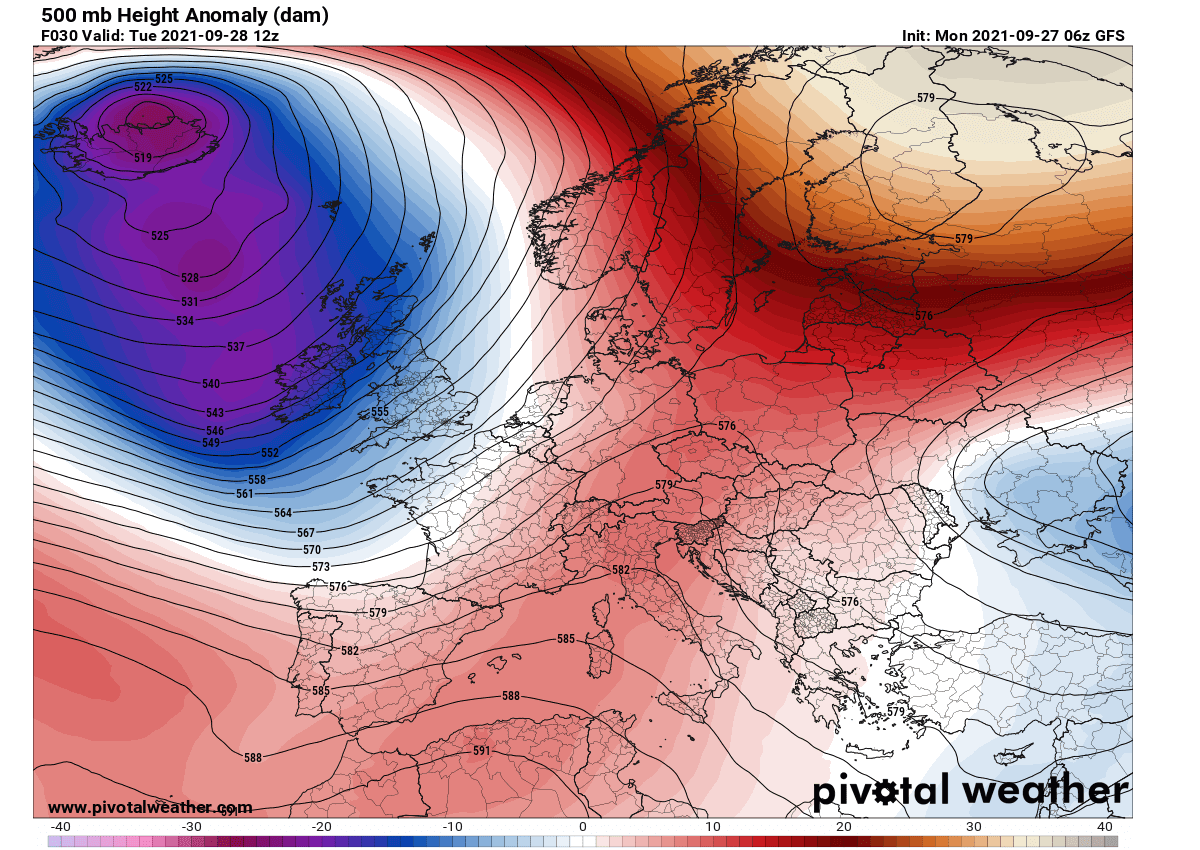
Associated with such a pattern, also a temperature picture is aligned this Monday. Strong southerly winds are delivering very warm air mass into Scandinavia that continues into the Arctic region. In response to the large upper high in Russia, cold weather is spread into eastern and southeastern Europe.
Over the Atlantic, a channel connection between Greenland and the areas to the south is resulting in a cold advection gradually spreading south with the maritime air mass.
Tonight, this pool of cold air mass will strengthen and deepen, in response to an upper wave moving into western Europe and deepening the central pressure over northwestern Europe. This will result in a significantly colder air mass advection towards Ireland and the UK on Tuesday.
The warmth to the east of this cyclone will continue across far northern Scandinavia inro the Arctic region, with about 12-15 °C warmer temperatures than normal for the end of September.

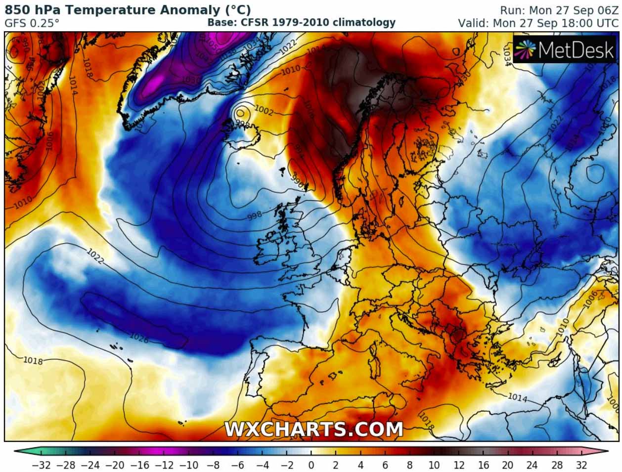
Temperatures across the lowest parts of the atmosphere will be about 6-8 °C colder than normal with daytime maximum staying in the low 10s across northern UK and Ireland on Tuesday.
Wednesday morning will be quite cold actually, with temperatures ending only a few degrees above zero in some areas. The lowest over Scotland and eastern Ireland, roughly 2-3 °C only. A few degrees warmer morning over southern England.

This generally cooler period is forecast to continue through much of this week and also into the next weekend, as a deep North Atlantic depression will keep maintaining the cold advection towards western Europe. Unsettled rainy and windy conditions should be expected.
Attached below is the GFS model Meteogram for Dublin (Ireland) and London (UK) over the next 14 days. We can clearly see the air mass over the next 5-7 days will remain colder than normal for the end of September and early days of October, with just a temporal warm plume on Thursday in response to another Atlantic low flyby to the northwest of Ireland and Scotland.
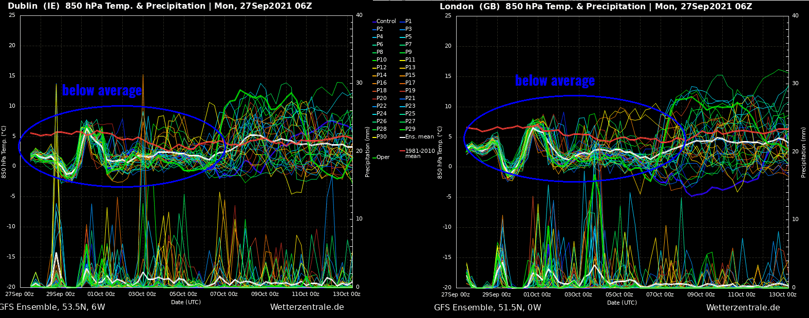
Despite some colder days, no significant weather threat is forecast.
A MASSIVE AMOUNT OF SNOW AND BLIZZARD FOR NORTHERN ICELAND
Tonight, a large surface depression over western Europe and the northeast North Atlantic begins developing a secondary low. This new rapidly organizing cyclone will be retrograding north-northwest along from the northern portions of the North Sea to the east of Faroe Islands. Considerably deepening while approaching Iceland by Tuesday morning.

The central pressure should push even below 970 mbar by noon Tuesday, while the low will keep moving northwest along northern Iceland until the afternoon hours tomorrow. This will increase the wind field around the low, becoming particularly significant across northern and northwestern Iceland during the second half of the day into Tuesday night.
Quite a lot of moisture coming up north with the rapidly intensifying surface low will be in place as well, combining with the much colder weather spreading south towards the low. This will create heavy to locally very heavy (orographic) snowfall across northern Iceland.
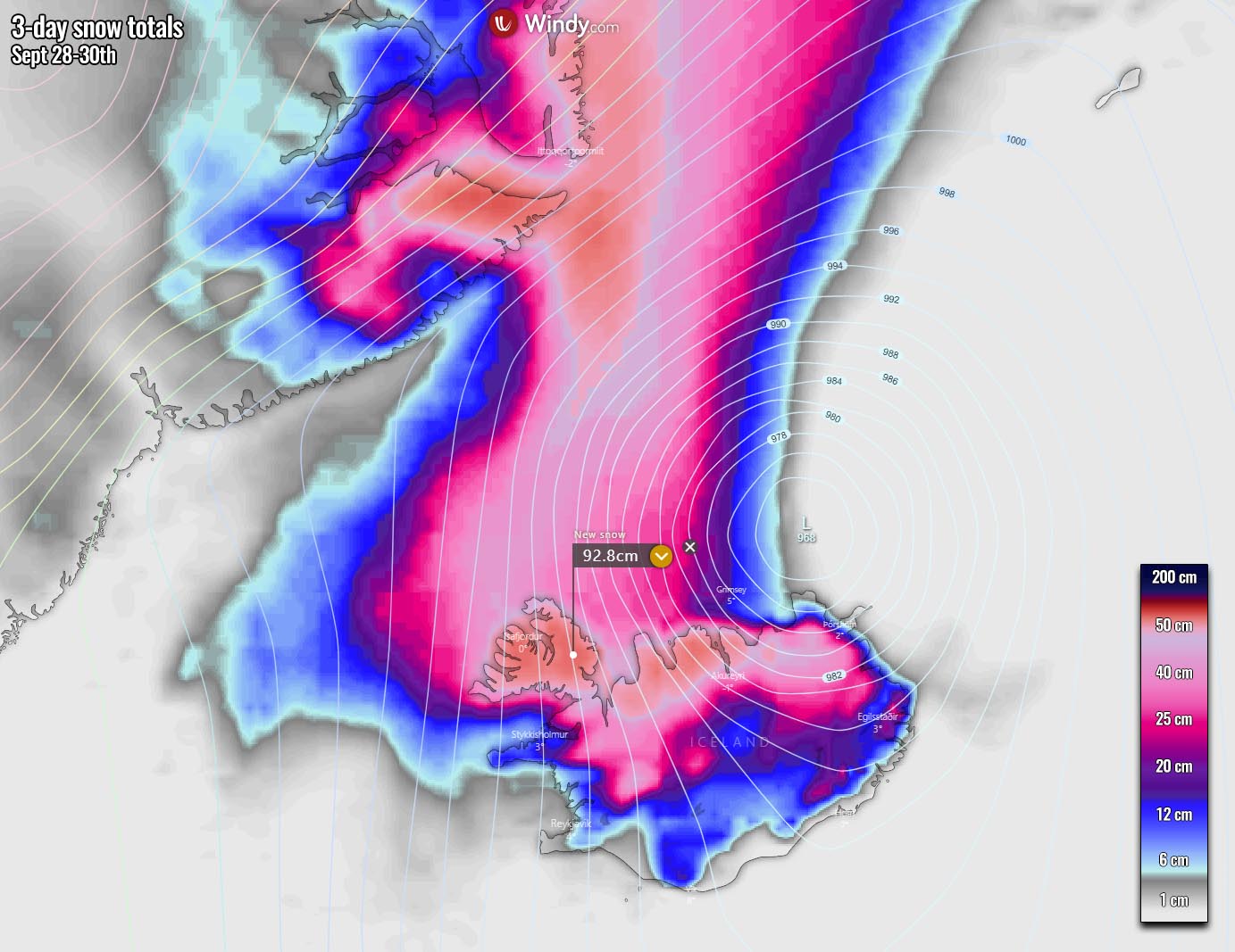
As the wind field will also be strong, the combination of both will result in dangerous snow blizzard conditions in these parts of Iceland. Whiteout conditions and major snow drifts are quite likely to be generated as well. Travels will be disrupted and could cause significant delays and impassable roads.
Although the most intense wind gusts will likely develop to the northwest of Iceland where the strongest pressure gradient will result, strong to locally severe wind gusts are expected in Iceland. Especially in the closed fjord valleys across the north and northwest Iceland where downslope winds will be enhanced by the complex terrain.
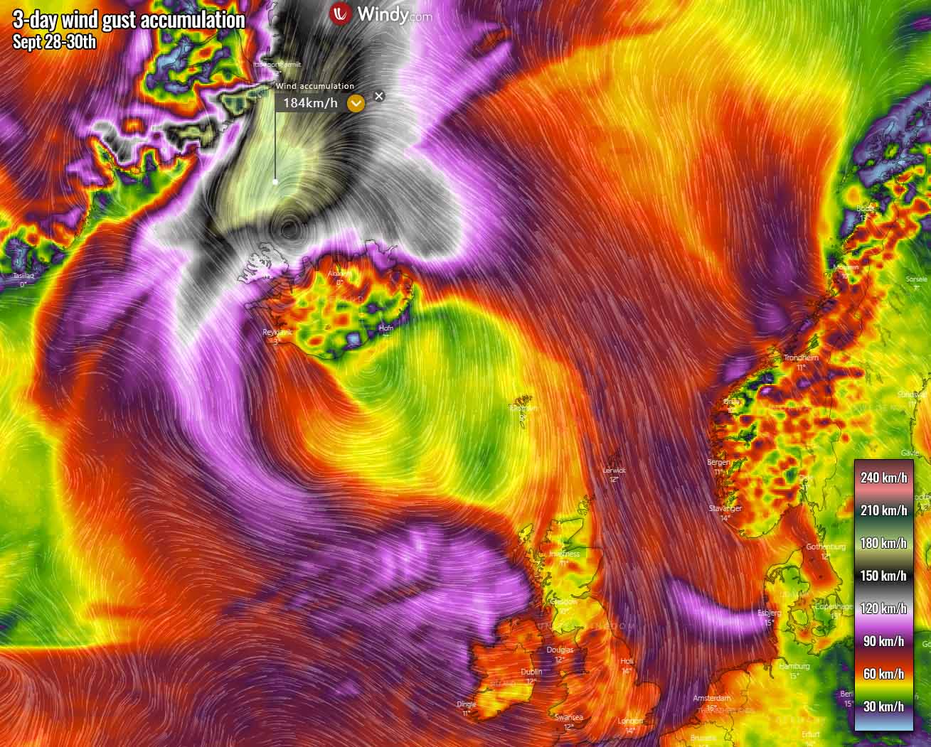
Peak wind gusts are likely to be extremely intense in the Denmark Strait, the narrow part of the Atlantic between Iceland and Greenland. Thanks to the very strong pressure gradient across the Strait, peak wind gusts could exceed 160-180 km/h there.
As the large depression remains in place, a relatively strong wind field also brings windy and unsettled conditions around its core, across the North Atlantic towards Ireland and western Scotland, as well as across the North Sea.
COLD SPREADS TOWARDS CENTRAL EUROPE AFTER WEDNESDAY, WEEKEND COULD BRING ANOTHER DEEP LOW INTO WESTERN EUROPE FROM THE ATLANTIC
The large North Atlantic depression is forecast to persist over the same part of the region through this whole week, so the cold advection also gradually spreads further east after Wednesday. Both Thursday and Friday will be a few degrees colder than normal over France, Benelux, and Germany, with Friday bringing some colder also across central Europe.

At the same time, a large cold pool associated with strong High over Russia will continue with very cold days across southeastern parts of Europe, especially over Turkey. The daytime temperature there will be about 6-10 °C below normal for this period. Mornings will be frosty across the eastern half of the country.
Later this week and over the weekend, the general weather forecast trends suggest another deep low could form under the existing North Atlantic depression. How intense and where the cyclone would travel is still rather unknown, however.
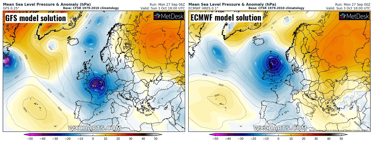
But the comparison chart between the GFS and ECMWF models above does hint at a good signal the low will likely develop. GFS develops the low over the English Channel, while the ECMWF model has the cyclone forming farther north, over Scotland.
These trends have to be monitored further, as both solutions would cause a strong frontal system and potentially severe winds and dangerous weather. Stay tuned for updates.
***Images in this article were provided by Windy, and Wetterzentrale.