An impressive satellite of frontal system approaching W Europe, Apr 25 – 19:20 UTC
Here is an evening visible satellite analysis of a well organized frontal system approaching western Europe this early evening. An intense surface low, its latest …
Here is an evening visible satellite analysis of a well organized frontal system approaching western Europe this early evening. An intense surface low, its latest …
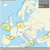
VALID FOR 26-04-2014 Complex scenario across Europe on Saturday. An upper low moves rapidly from Tyrrhenian sea towards Greece, another deep upper low with intense …
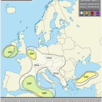
VALID FOR 25-04-2014 A deep trough over E Atlantic / W Europe moves further east onto UK while its southern flank cuts off into an …
Scattered storms are also ongoing across the SLGT risk area issued for the Benelux and NW Germany where weak shear coupled with moderate instability is …
Rapid thunderstorm initiation underway across the S-CNTRL Balkans in the last 2 hours as a response to strong diurnal heating and weakening capping inversion. Widespread …
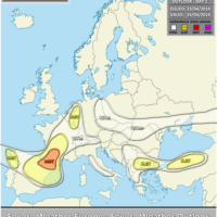
VALID FOR 24-04-2014 A ridge dominating pattern across Europe with large pressure centered over Scandinavia. The deep trough from the E Atlantic enters SW Europe …
A new season is approaching. Meteorological spring will officially begin on March 1st and will last to May 31st. All the official weather statistics for …
The second week of November will bring a significant winter storm that is forecast to spread across the Midwest and the central United States late …