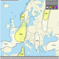
Outlook day 1 (valid: 22/05/2014)
VALID FOR 22-05-2014 A powerful upper low is gradually retreating northwards from SW into W Europe. A ridge maintains to the east with a weak …
VALID FOR 22-05-2014 A powerful upper low is gradually retreating northwards from SW into W Europe. A ridge maintains to the east with a weak …

VALID FOR 23-05-2014 On Friday, a large upper low over W Europe slowly spreading east towards CNTRL Europe while weak upper low rotates over Turkey. …

VALID BETWEEN 24-05-2014 AND 26-05-2014 On DAY 3-5 the upper low remains centered over W Europe and gradually weakens through the weekend. A SFC front …

Mesoscale Discussion #008 (valid 21/05/2014 15-21 UTC) *** Environmetal conditions across the discussion area are becoming increasingly supportive of a dangerous severe weather outbreak in …
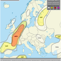
VALID FOR 21-05-2014 A powerful upper low is centered over NW Iberia Europe, while an upper ridge builds up over the rest of Europe merging …

VALID FOR 22-05-2014 A powerful upper low is gradually retreating northwards over western Europe and gradually spreading east. A ridge maintains to the east with …

VALID BETWEEN 23-05-2014 AND 25-05-2014 On DAY 3-5 the powerful upper low remains centered over W Europe and gradually weakens through the weekend. Unstable and …

Mesoscale Discussion #007 (valid 20/05/2014 15-21 UTC) Numerours TCUs are developing across the SLGT/MDT risk area over France and Benelux. Latest sfc data show significantly …