Outlook day 1 (valid: 12/02/2017)
VALID FOR 12-02-2017 An extensive upper ridge dominates Europe, centered across the N Atlantic and NW Europe. A deep upper low is rotating SW of …
VALID FOR 12-02-2017 An extensive upper ridge dominates Europe, centered across the N Atlantic and NW Europe. A deep upper low is rotating SW of …
*** Powerful sting jet with damaging winds 120-160 km/h across the Bay of Biscay through the next 6-9 hours *** An impressive airmass satellite animation …
*** Hurricane force Bora winds outlook for the E-NE Adriatic region (SW Slovenia, NW Croatia-Kvarner) and excessive snowfall for Marche / Abruzzo regions in central …
Latest SWE Outlook for excessive snowfall across Europe until Tuesday: Here is this morning’s windchill temperature analysis across Europe, polar airmass with extremely cold winds …
An overview of the pattern through the next 3 days when some areas in Europe will be experiencing excessive snowfall. One of these areas is …
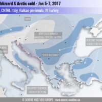
This is a follow-up on the evolution of a significant arctic outbreak through the next few days as a very cold airmass is advecting into …
Short review of mt. Etna volcano powerful eruptions in E Sicily island, Italy, occured from Dec 2nd to Dec 4th, 2015. Activity is still on …
Meteorological winter is coming to an end, and with March a new meteorological season begins. March is the first spring month and it also usually …