Yet another hot day for parts of western, southern and southeastern Europe today. The strong ridge persists, centered over France today and extending from the Iberian peninsula across S-CNTRL Europe into the Balkans. The shortwave trough that affected Germany and Czech Republic yesterday moves the weather across E-CNTRL Europe today, with severe thunderstorms expected. Ahead of the severe weather, it will be very hot across E-SE Europe!
A look by region
Pannonian basin and S Balkans: hot day ahead in this region as well. Ahead of thunderstorms expected in the afternoon temperatures will reach above 30 °C across most of the Pannonian basin, with peak temperatures reaching 35-36 °C in E Croatia, N Serbia and S Hungary! E Hungary and N Romania were hit by an intense squall line earlier this morning, so temperatures will not be quite as high there. Also very hot in S Romania, parts of Bulgaria and N-CNTRL Greece with peak temperatures 35-37 °C!
WRF model guidance for temperatures across SE Europe today. Map: Meteoadriatic
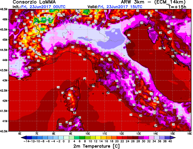
Northern Italy: will be very hot again today, with various models indicating temperatures peaking at 36-38 °C in the Po plain.
WRF model guidance for temperatures across northern Italy today. Map: Consorzio LaMMA
Iberian Peninsula: continues very hot today. Peak temperatures of 36-38 °C expected over southern, eastern and northeastern Spain and southern Portugal. Hut, but several degrees down from the 42-44 °C heat earlier in the week.
ARPEGE model guidance temperatures across the Iberian Peninsula today. Map: Meteociel.fr


