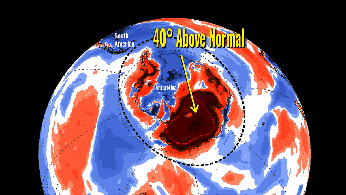
The warmest temperature ever recorded in a permanent weather station of the Antarctic Plateau in 66 operational years has been reached during an unprecedented heatwave in the Concordia-Dome C research station on March 18th, 2022. A powerful inflow of warm winds from Australia brought temperatures over East Antarctica up to 47 degrees C or 85 degrees Fahrenheit, above average. This unusual and unprecedented warmth is smashing temperature records in the coldest location on the planet.
UNPRECEDENTED HEATWAVE IN ANTARCTICA
East Antarctica, the coldest place on Earth, is experiencing an incredible heatwave unlike any ever observed, according to model-based data sources and on-site measurements performed in the last few days.
The area-averaged surface air temperature anomaly over the Antarctica continent these days is almost +4.0 ° C, which is +7.2 ° F. However, in a large part of East Antarctica temperatures anomalies are close to 30 ° C (54 ° F) above average for this time of the year.
Locally, as reported for instance by a weather station in Concordia over the Antarctic plateau, the temperature is almost 50 ° C (90 ° F) above average. These values make this heatwave exceptional, specifically for the internal part of Antarctica.
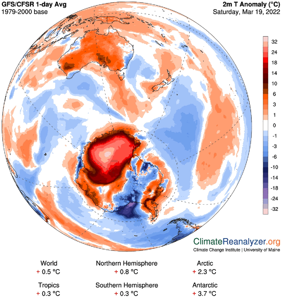
This unusual and unprecedented heatwave is smashing records in the coldest location on the planet. The image above shows a model-based chart of regional 2 meters temperature anomaly published by the Climate Change Institute at the University of Maine based on data interpolated on 19 March. 2 meters Temperature Anomaly refers to the departure of the current day’s forecasted temperature from a long-term mean for the same day of the year.
The anomalies are based on a 1979-2000 reference climatology derived from the NCEP Climate Forecast System Reanalysis (CFSR). Temperatures are 20 to 30°C above normal for the period in the interior of the great white continent, and largely positive on the coast. Many records are broken.
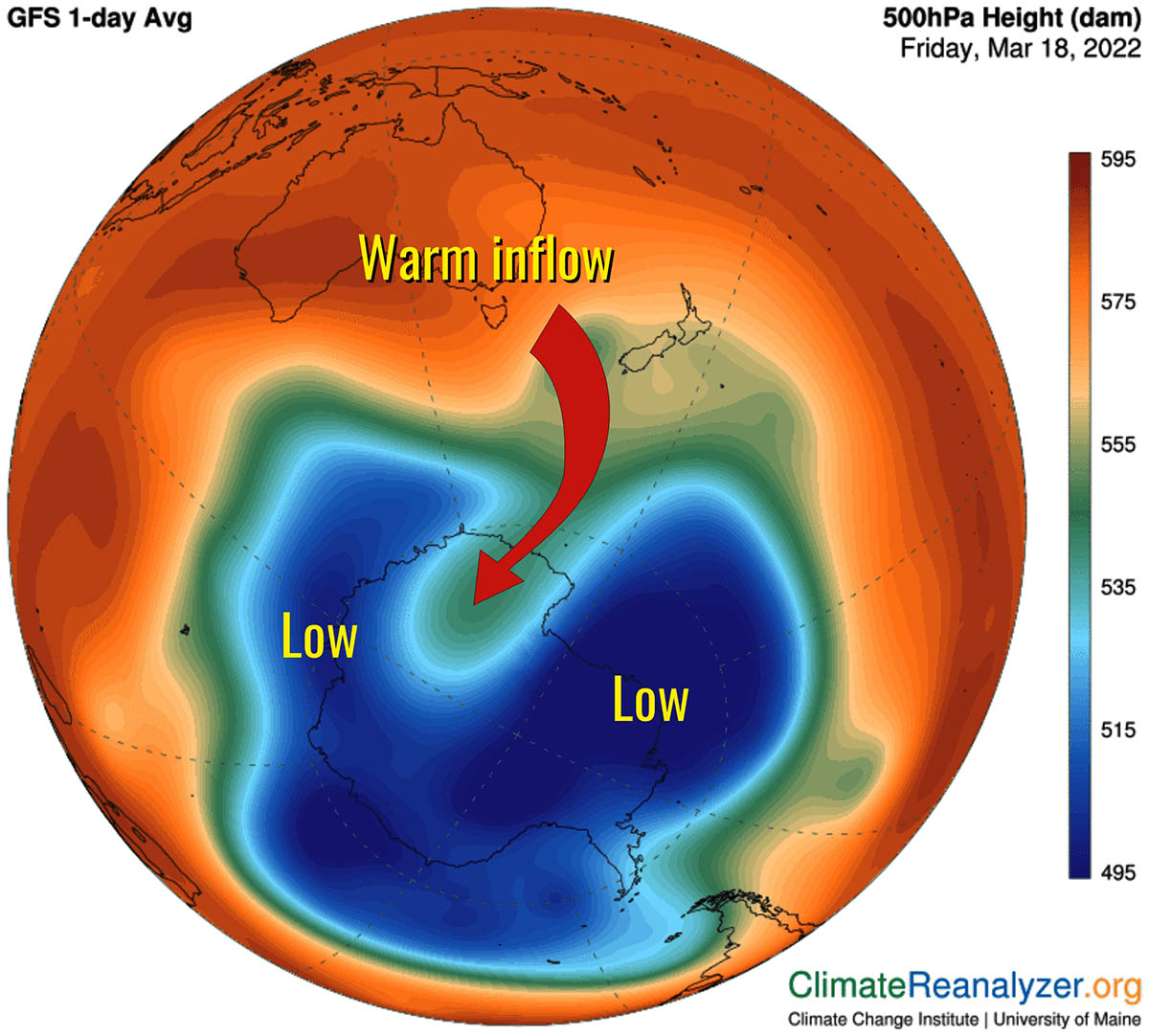
This late-summer polar heatwave gripping more than half of Antarctica is caused by Northerly winds flowing between an upper-level trough and upper-level ridge allowing warm air to travel across the Southern Ocean and reach Antarctica this week.
This anomalous circumstance is pushing mild winds from Australia towards Antarctica and the warm inflow basically reaches the most internal part of The Antarctic Continent.
The warm air mass of the heatwave traveled from Australia towards Antarctica has also been making parts of southeastern Australia feel unseasonably warm. On Thursday, the town of Hobart climbed almost 10 ° C above average to a top of 29.2 ° C, while some parts of the state had their warmest March day in several years.
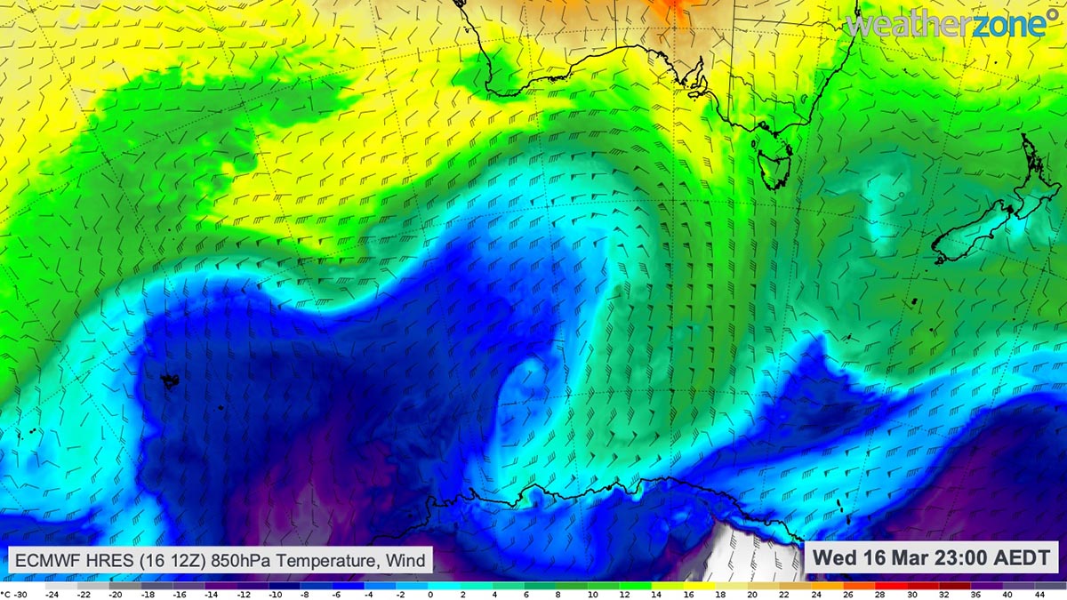
The heatwave started a few days ago. The image above shows this tongue of warm air penetrating the polar continent on Wednesday, March 16th. The warmest temperature strikes the coast of Antarctica to the south of Australia.
Below, we prepared a video showing first the 700 hPa geopotential height in decameters with the integrated water vapor transport (black arrows), and the equivalent potential temperature in Kelvin with the wind in knots. This animation gives an idea of the powerful inflow of warm air from Australia starting March 16th.
The injection of warm air saw Australia’s Casey Research Station in the Antarctic coast register a maximum temperature of 5.6 ° C on Wednesday, March 16. This is the station’s highest March temperature on record, with data available back to 1989.
Before, the latest date to reach 5.6 ° C at Casey Station on this side of the winter solstice was February 5th in 2008, more than one month earlier than this new record. In Antarctica, at the moment, 82 permanent research stations exist. Casey Station’s highest temperature on record was 9.2 ° C on January 24th, 2020. Its lowest temperature was minus 34.0 ° C on August 24th, 2005.
RESEARCH STATIONS IN ANTARCTICA
The map below shows the 82 permanent research stations dotted across the Antarctic. Among those bases, forty are opened all year long. The others host scientific research during the Austral summer, between about November and February. The location and capacity of these stations also vary significantly from one to another.
For instance, the US McMurdo station is the biggest scientific base in Antarctica, established on an island and open all year-long. Here, up to 1,000 people live and work during the Austral summer. On the contrary, a small seasonal station such as the Belgian Princess Elisabeth Station is only open during the summer and can host up to 20 people.
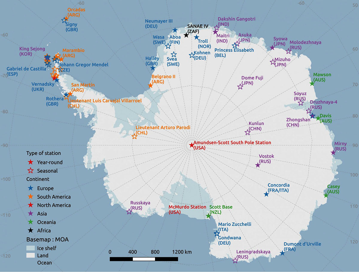
Most of the research stations are of course located along (or very close to) the Antarctic coasts. Nevertheless, a number of research stations are located on the ice sheet plateau, often above 3000 meters above sea level. The U.S. built the Amundsen-Scott South Pole Station right at the geographical South Pole.
CONCORDIA STATION AT DOME C
The Italian-French research station Concordia at Dome C operates all year-long thanks to logistic and scientific cooperation between Italy and France. Thanks to its geographical position, as the Russian research station Vostok, the weather instruments best recorded this improbable warmth event.
The climate at Dome C where Concordia Station is located is frigid all year round, being one of the coldest places on Earth. It has a polar ice cap climate (Köppen EF), with maximums ranging from −24.8 and -36.1 ° C (−12.6 and -33.0 ° F) in December to −62.0 and -68.7 ° C (−80 and -91.7 ° F) in May.
The annual average air temperature is −54.5 ° C (−66.1 ° F). Concordia station never recorded a temperature above freezing. The warmest temperature recorded was −5.4 ° C (22.3 ° F) in January.
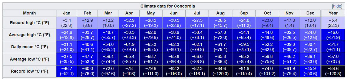
Temperatures in Concordia can fall below −80 ° C (−112 ° F) in winter. The coldest recorded temperature was −84.6 ° C (−120.3 ° F) in August 2010 which is close to the coldest temperatures ever recorded on Earth. Humidity is low and it is also very dry, with very little precipitation throughout the year.
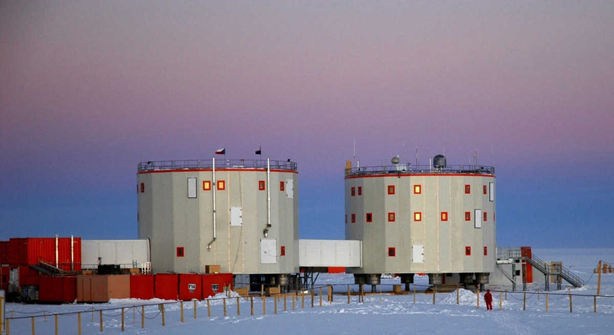
The location Dome C does not experience the katabatic winds typical for the coastal regions of Antarctica because of its elevated location and its relative distance from the edges of the Antarctic Plateau. The typical wind speed in winter is 2.8 m/s. The image below by Stephen Hudson is taken from the 32 meters high weather tower and shows the remoteness of the location.
The research facility Concordia Research Station opened in 2005 at 3,233 meters (10,607 feet) above sea level at a location called Dome C on the Antarctic Plateau, Antarctica. It is located 1,100 kilometers (680 miles) inland from the French research station at Dumont D’Urville, 1,100 kilometers (680 miles) inland from Australia’s Casey Station, and 1,200 kilometers (750 miles) inland from the Italian Mario Zucchelli Station at Terra Nova Bay.
Russia’s Vostok Station is 560 kilometers (350 miles) away. The Geographic South Pole is 1,670 kilometers (1,040 miles) away. Concordia Station is the third permanent, all-year research station on the Antarctic Plateau besides Vostok Station (Russian) and the Amundsen–Scott South Pole Station (U.S.) at the Geographic South Pole. It is jointly operated by scientists from France and Italy and regularly hosts scientists from the European Space Agency.
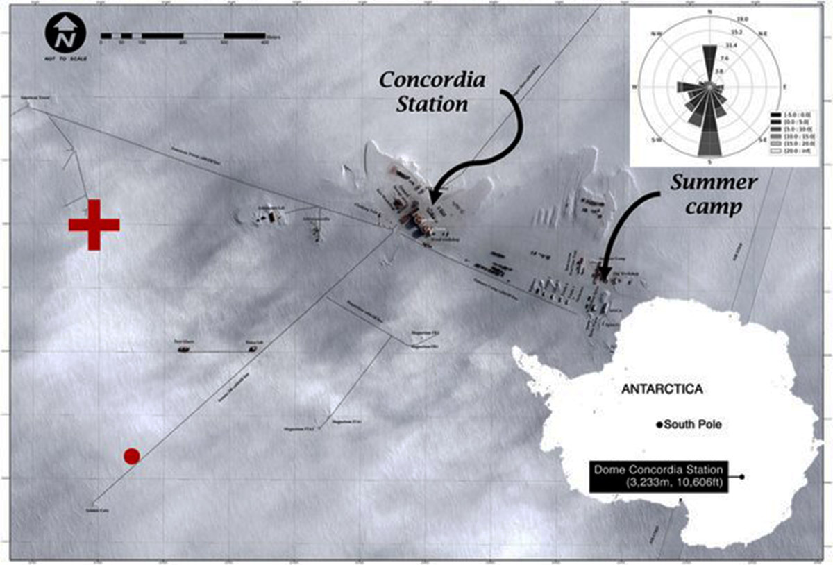
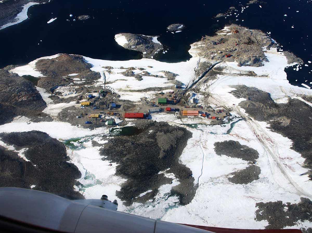
The image above is the aerial view of the Concordia station. The red cross marks the position of the automatic weather station (Vaisala Milos 520). The dominant wind rose is shown in the upper right‐hand corner. The location of the Concordia station is shown in the lower right‐hand corner (Pléiade Satellite Image—Concordia Station, Antarctica at CNES 2016, Distribution Airbus DS).
During this heatwave, the final high on March 18th in Concordia was -11.5 recorded at 04:27 UTC. This represents the warmest temperature ever recorded in a permanent weather station of the Antarctic Plateau in 66 operational years (since 1957) Stefano Di Battista Reported.
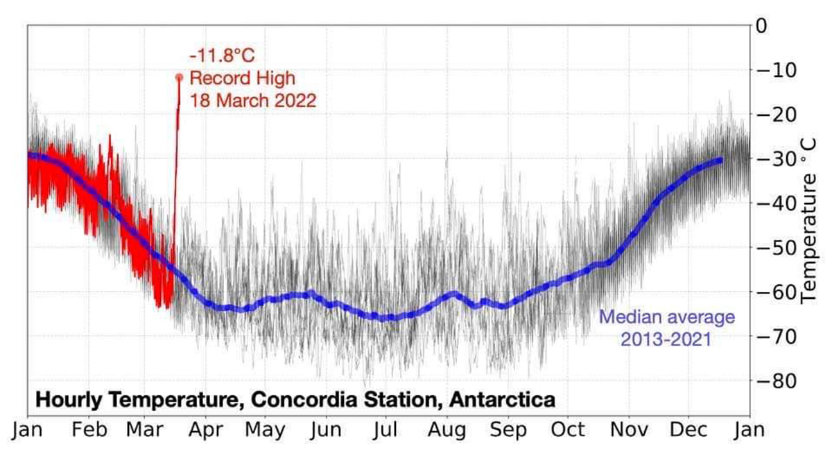
In the image above the hourly temperature recorded in Concordia station at Dome C, 3233 m a.s.l. In blue the normal temperature is around -58 ° C for this period of the year. In red are the 2022 temperatures and the oldest data in grey.
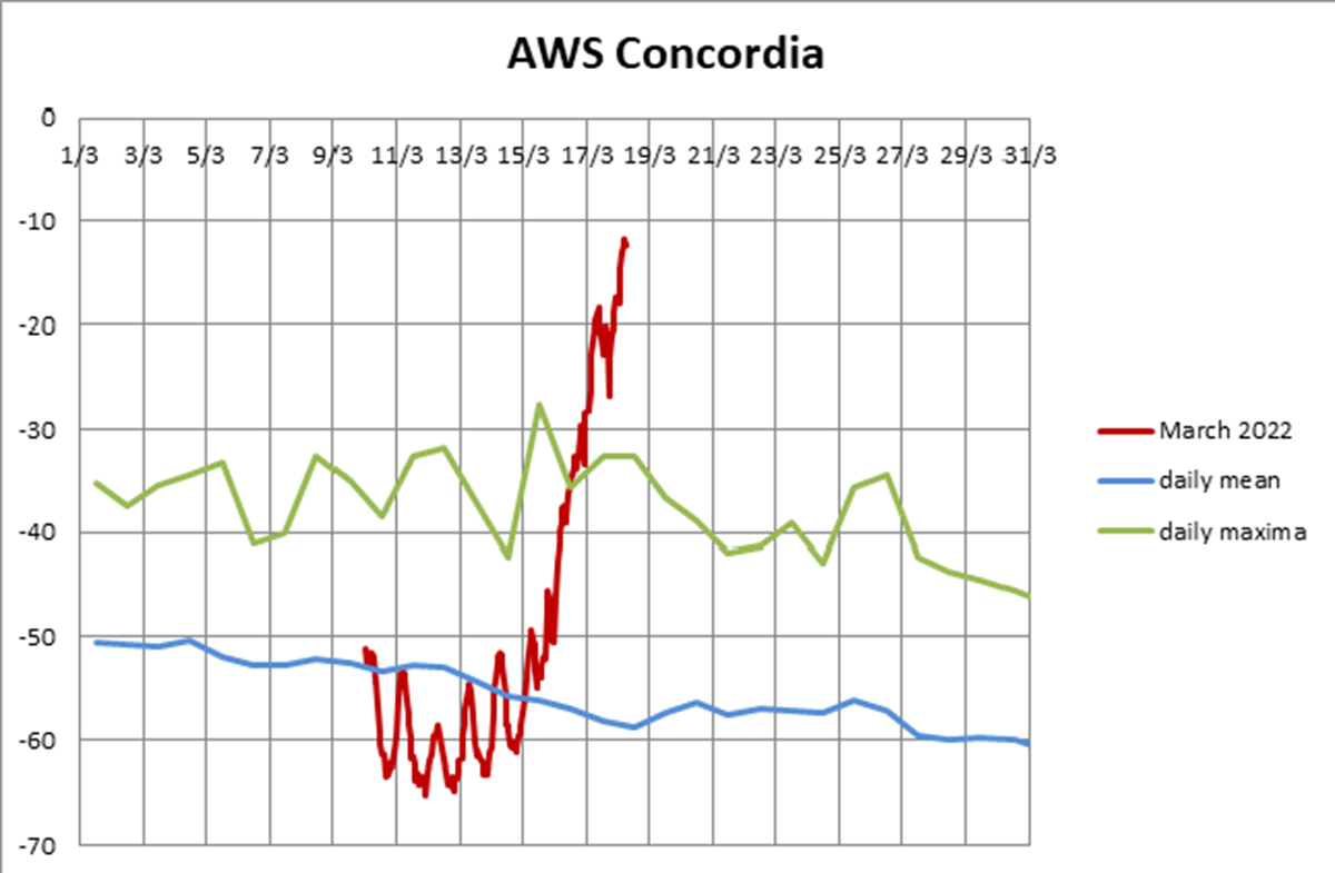
On March 18th the anomaly is between +46 and +47 ° C (83 and 85 ° F). The recorded value during the heatwave is unequivocally out of range with respect to the 2013-2021 time series. In the image below, the detail of temperatures in March 2022 in Concordia so far.
Also in the Vostok research station on March 19th at 06 Zulu temperature was -31.0 ° C which is about 2 ° C higher than the previous record. Already the 17th in this research station the value of -20.3 ° C set the new monthly record but also exceeded the maximum of February (-22.2 ° C on 2009 day 6) and November (-22.0 ° C on 1974, day 23)
But the new monthly high in Vostok at the peak of the heatwave was recorded on 18th March with -17.7 ° C. This value exceeds by about 15 ° C the previous one and it is also the highest since December 23th 2018 (-14.6 ° C).
As the heatwave hits east Antarctica the temperature remains stable at the southern pole station with a typical value of -51.4 ° C for mid-March.
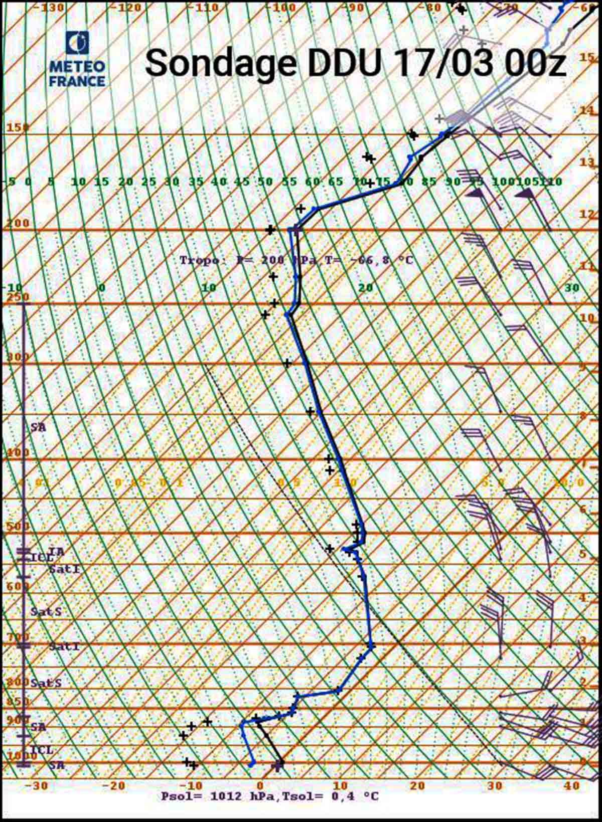
The image above shows the radiosonde launched by the research station scientists on-site on the 17th and displays the very atypical nature of the air mass. Northerly flow over the entire profile above 700hPa, extremely mild (iso -10 ° C at 4000 m), and tropopause at 200 hectopascal which is exceptionally high for the latitude.
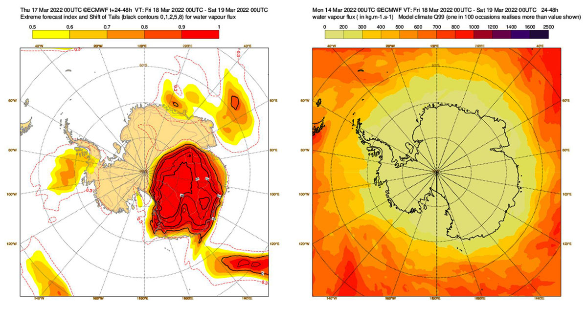
Another way to possibly visualize the extraordinary magnitude of the atmospheric river surging the warm inflow over eastern Antarctica is the ECMWF water vapor flux SOT index, which exceeds 8 for large areas on March 17 and 18.
THE ANOMALOUS PATTERN DURING THE HEATWAVE AND THE JET STREAM
The image below shows the 250 hectopascal height in decameters which was exceptionally high for inland East Antarctica and above 10,000 meters. Powerful north winds flew from South Australia towards East Antarctica thanks to a rare synoptic pattern at all elevations.
You can see the jet stream meandering over a large part of the Antarctic Continent on March 18th, with a powerful wind speed anomaly that is displayed in gray color.
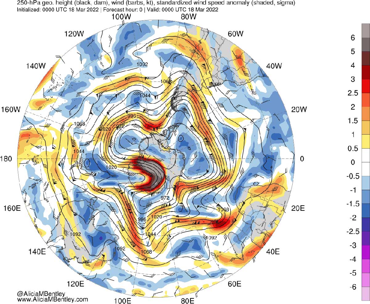
At the geopotential height of 500 hectopascals, a vast positive anomaly is associated with a High-pressure system at all the elevations. This structure appears flattened on both sides by two deep lows with pressure at the ground around 950 millibars.
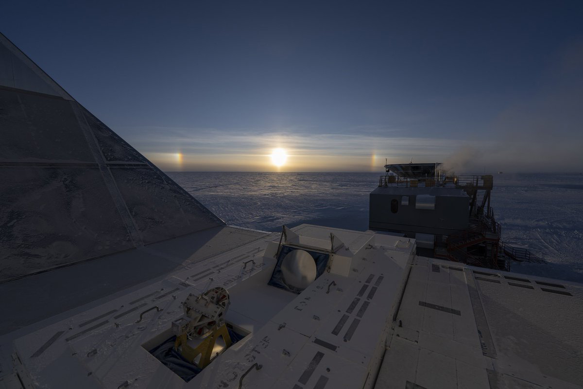
This record-breaking event occurs right before the beginning of the long polar night. In the picture below, Late sun dogs at the South Pole are low in the sky, possibly the last of the season before the equinox sunset next week and the commencement of the long polar night at 90°South. Picture credits Aman Chokshi
But Antarctica is not new to such anomalous heat waves. Antarctica’s peninsula, the area pointing toward South America, is one of the fastest-warming places on Earth. In just the past fifty years, temperatures have increased 5 ° C on the continent, and around 87 percent of glaciers along the peninsula’s west coast have receded during that time.
Two years ago, On February 6, thermometers at the Esperanza Base on the northern tip of the Antarctica Peninsula marked a temperature of 18.3 ° C (64.9 ° F), about the same temperature as Los Angeles that day. The heatwave arrived on Feb. 5 and continued until Feb. 13.
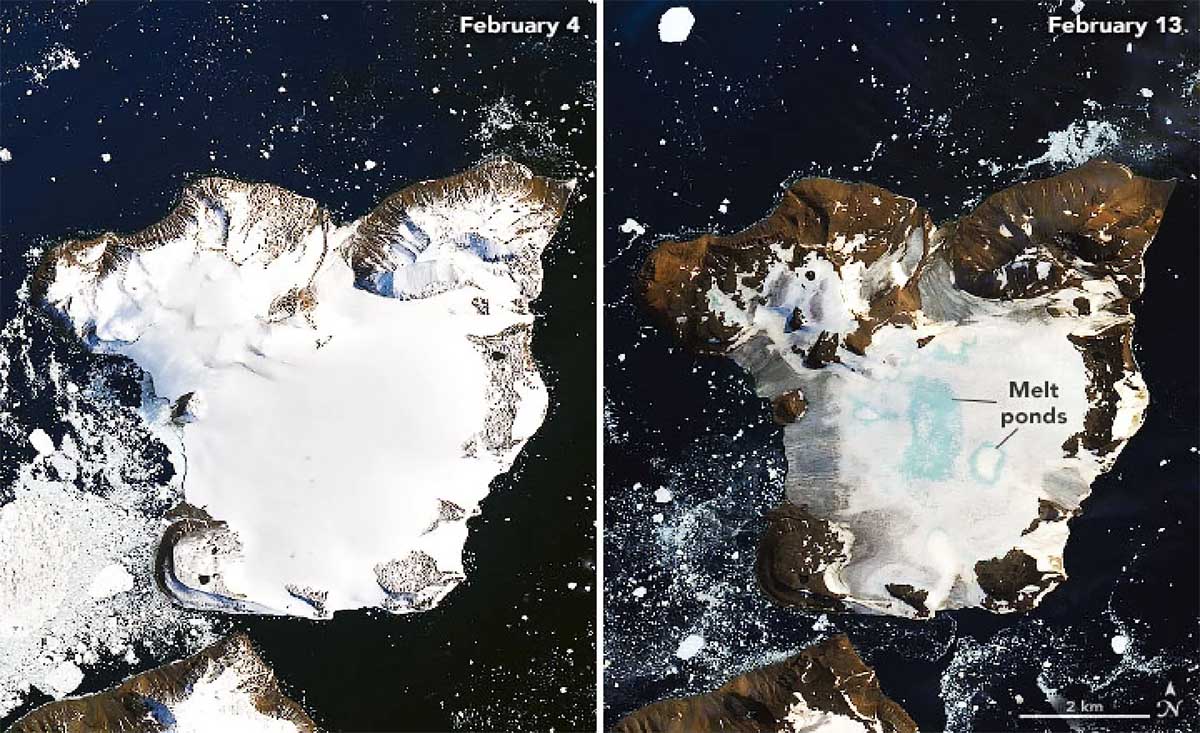
NASA’s Earth Observatory released two images showing the effects of this heatwave on Antarctica’s Eagle Island ice cap. Before and after images show a dramatic decrease in ice and snow, as large portions of the ground are visible and bright blue melted ponds can be seen at the center of the island.
A SEASON OF EXTREME EVENTS IN ANTARCTICA
A warm summer in Antarctica and several strong föhn wind events smashed the Antarctic ice extent setting an all-time record low in 44 years of satellite observations. It is impressive to witness this frozen ocean melting down, and for the first time since satellite measurement began in 1979, the Southern Ocean ice coverage has dropped below 2 million square kilometers on February 25th, 2022.

The sea ice extent is one of the key components of the polar climate system. It has been an increasing focus of consideration in recent years, mostly because of the massive and rapid decrease in the Arctic sea ice extent.
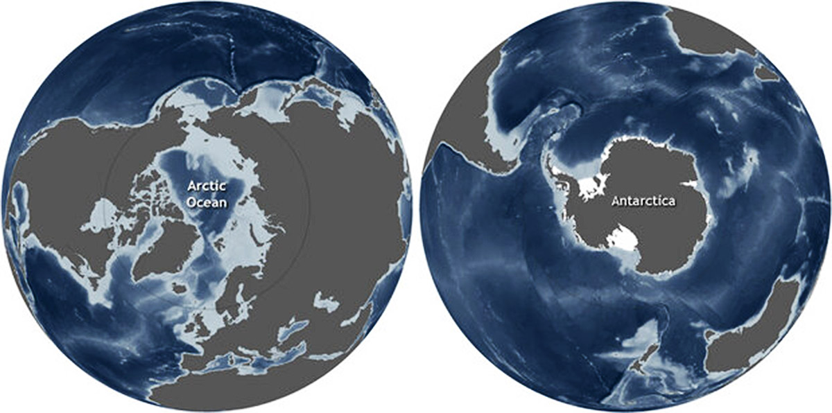
The Arctic and Antarctic are geographic opposites, and not just because they stand on opposite ends of the Earth’s globe. They also have opposite land-sea arrangements. In the Arctic, continents surround an ocean, while in Antarctica the continent is surrounded by oceans.
These differences in the arrangement of land and water contribute to differences in each polar region’s climate, oceanic and atmospheric circulation patterns, and ice.
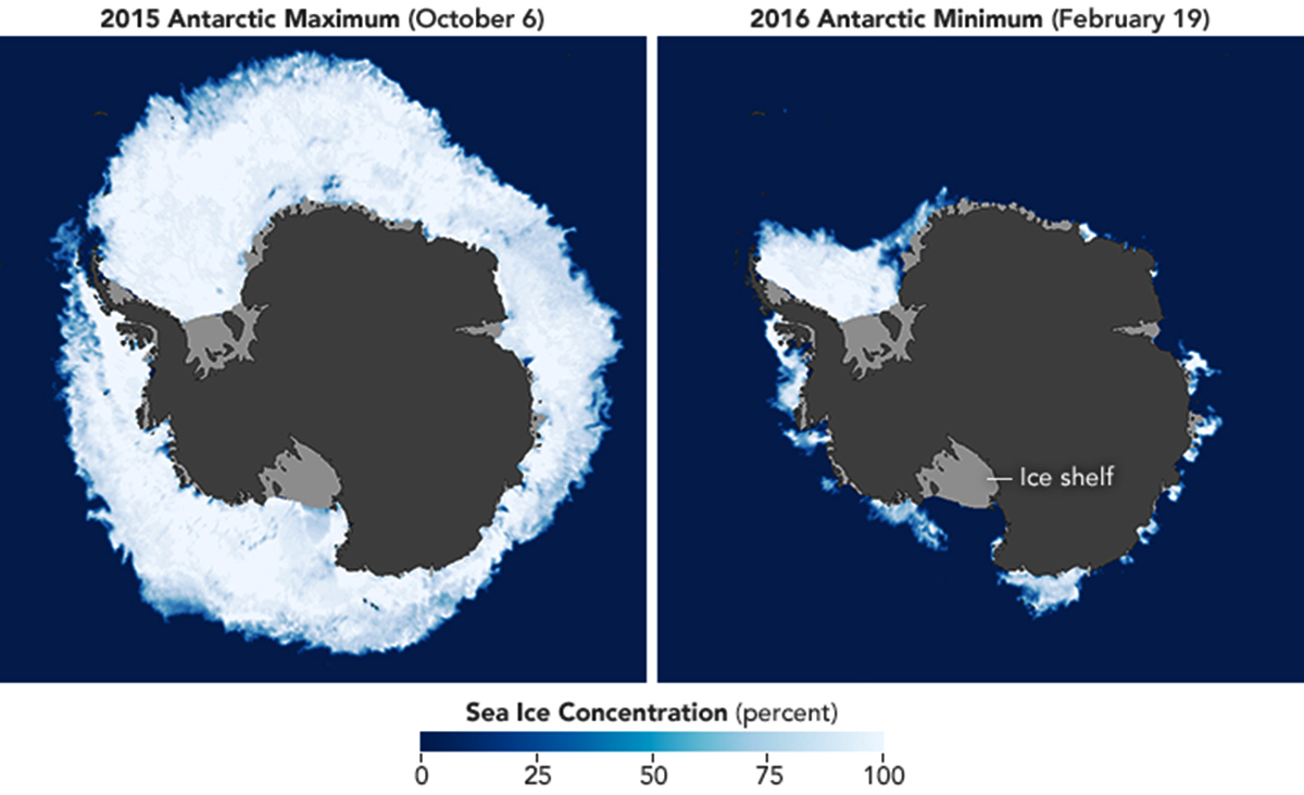
Antarctic ice normally peaks in September or October and reaches a minimum in February. In some places, sea ice melts completely in the summer. In the NASA Earth Observatory maps below by Joshua Stevens, using AMSR2 data supplied by GCOM-W1/JAXA, extent in Antarctica in the season 2015-2016
The cold waters around Antarctica allow rapid ice formation in winter. At its maximum extent in September, ice cover is around 16 million square kilometers or 6.2 million square miles, shrinking to about 2 million square kilometers or 0.77 million square miles in February. This is a much larger fluctuation than in the Arctic, where the configuration of the continents encourages the retention of ice for longer periods.
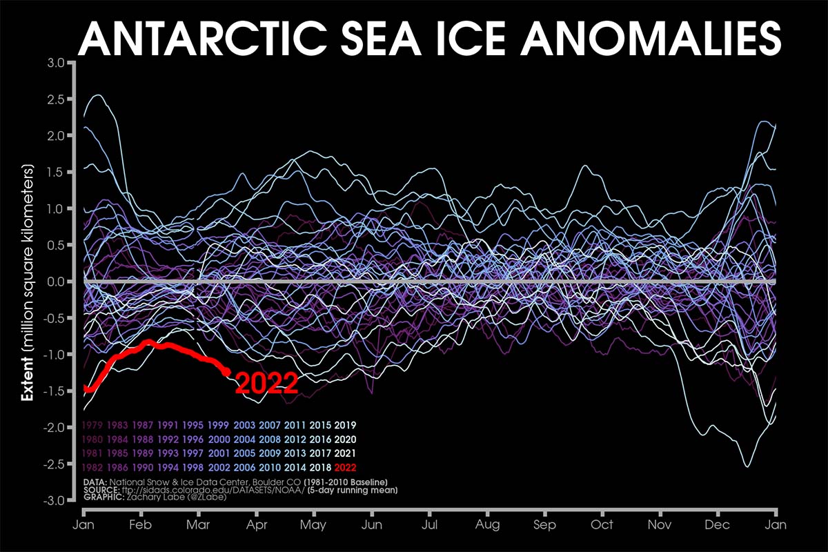
Although February 25th, 2022 does not represent the most negative anomaly of the record as a whole, it was so for the end of February when the usual annual climatic minimum occurs. This is also clearly evident in the image below which shows the Antarctic pack extent anomalies stretching from January 1979 to the present-day thanks to satellite-era, NSIDC, DMSP SSM/I-SSMIS.
The anomalies are plotted by using a five-day running mean from the 1981-2010 climatological baseline and updated to February 28th. The graphic is set by Zachari Labe.
The present sea ice conditions for the end of March are in line with the greatest negative anomaly ever recorded in the satellite in Antarctica.
The low extent of the ice pack is noticeable in the Weddell Sea, east of the Antarctic Peninsula, which because of its circular current retains much more ice from year to year than the other parts of the Antarctic coast. Nevertheless, The Antarctic summer was indeed pretty warm this year already in the first part of the austral summer.
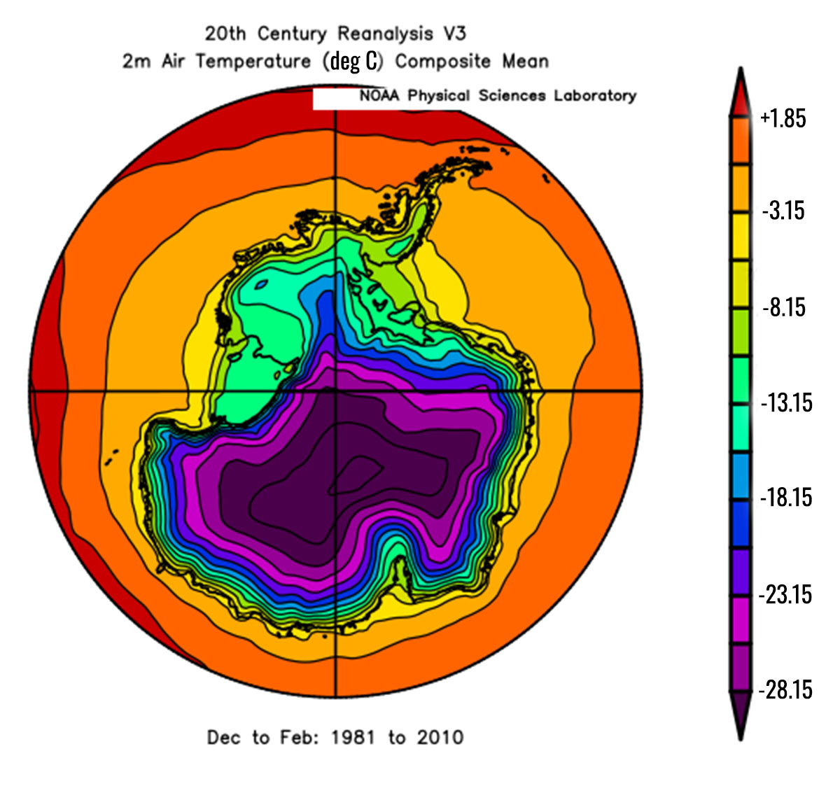
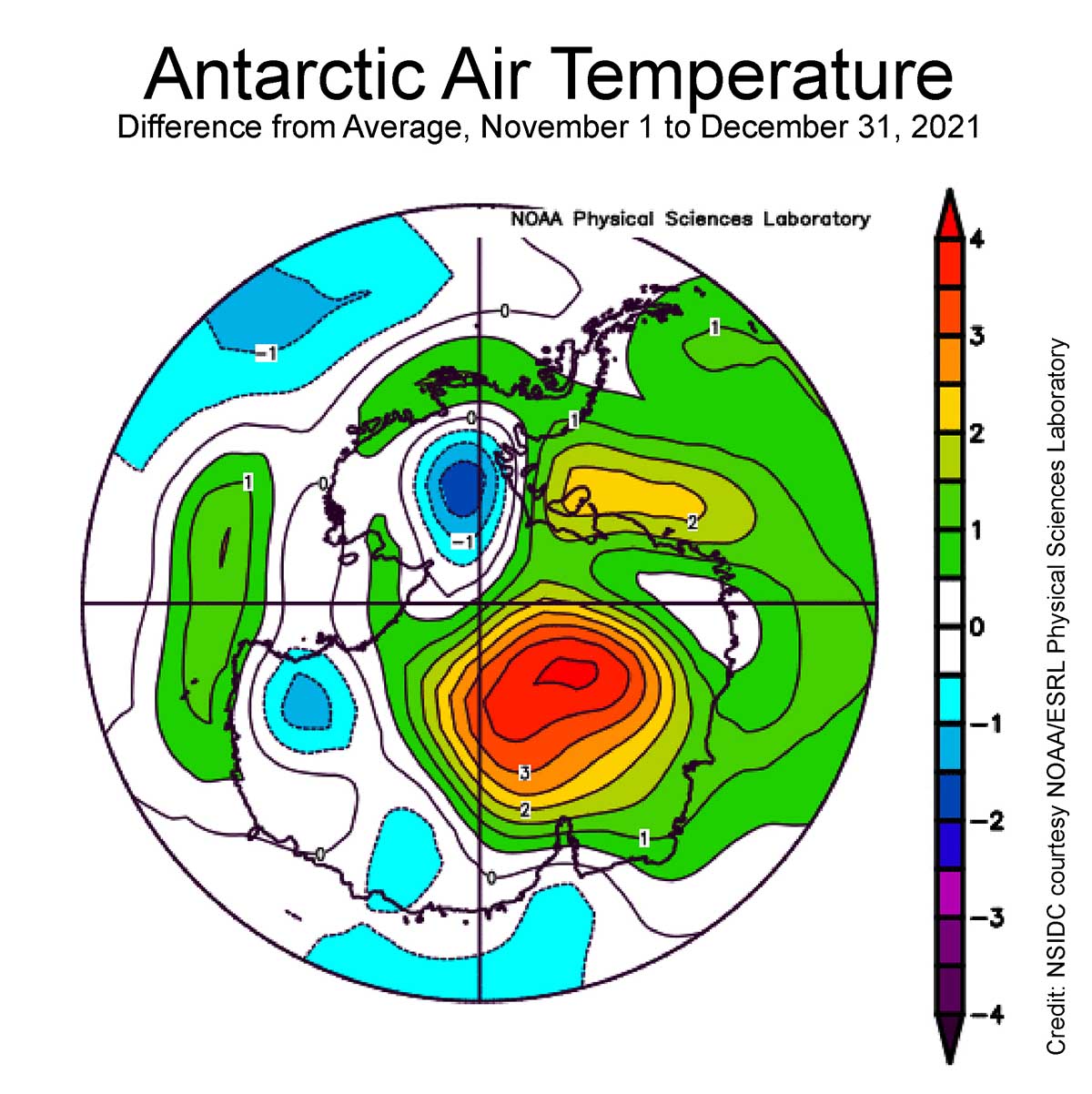
As a yardstick, the image above reports the 1981-2010 mean summer air temperature in Antarctica thanks to the NOAA Physical Science Laboratory. In the image below the average temperature for the first part of the summer shows a massive positive anomaly up to 4 ° C in a large part of Antarctica. The image shows the departure from mean air temperature, in ° C. Yellows and reds indicate higher than average temperatures; blues and purples indicate lower than average temperatures.
The interior of the East Antarctic Ice Sheet was rather warm but did not approach the melting temperature of course. On the other side, in coastal areas temperature approached more easily and frequently the melting point during the summer season.
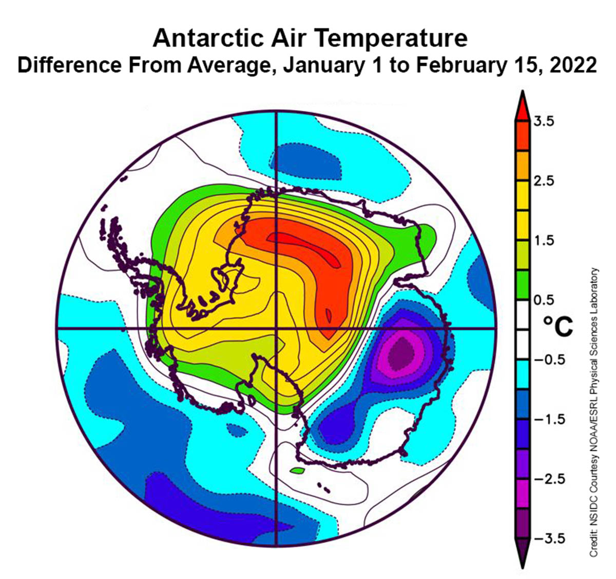
Antarctic climate conditions for the second half of the summer, between January 1 and February 15, have been driven by a strong Amundsen Sea Low located westward of its usual position. Strong northwest winds again flew across the Antarctic Peninsula with several föhn events. Therefore, recursively dry, warm, down-slope winds occurred on the downside of the mountain range.
The image below credits NSIDC courtesy NOAA Earth System Research Laboratory, shows the departure from average air temperature over Antarctica at the 925 hPa level, in ° C, from January 1 to February 15, 2022. Yellows and reds indicate higher than average temperatures; blues and purples indicate lower than average temperatures.
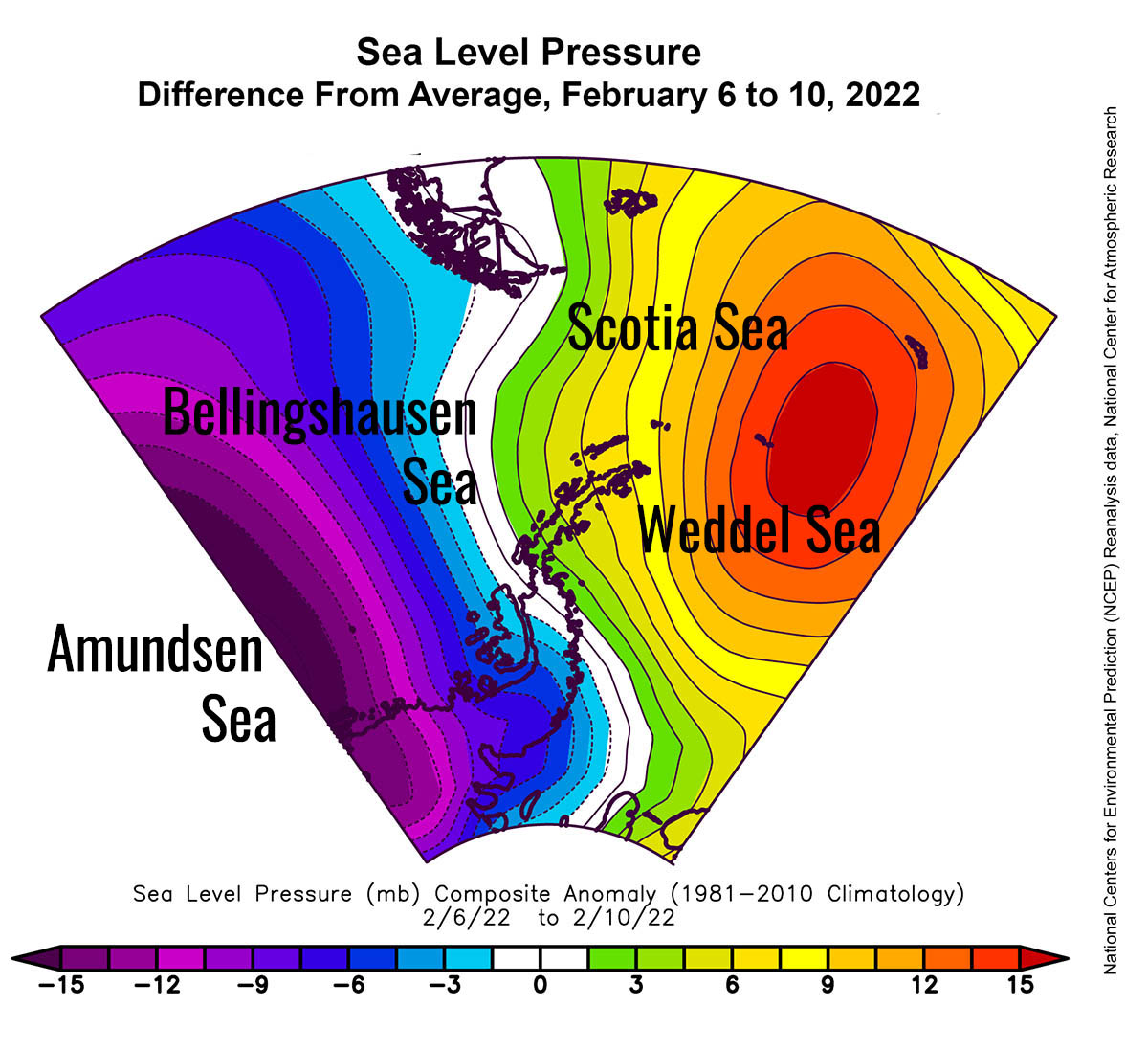
The image below credits National Centers for Environmental Prediction (NCEP) Reanalysis data, National Center for Atmospheric Research, shows mean sea level pressure for the Antarctic Peninsula from February 6 to 10, 2022.
During this period, an extremely intense event of föhn hit the eastern Peninsula. On the windward side of the Peninsula, stau conditions produced intense snowfalls there. Such a synoptic pattern with high pressure over the Scotia Sea and the low pressure over the Amundsen Sea produces strong N-NW winds. More than 50% of the Peninsula’s ice cover was interested by melting during this period.
Föhn is a warm, dry, downslope wind descending the lee side of the European Alps as a result of synoptic-scale, cross-barrier flow over the mountain range. The air in the near-surface flow originates at or above the main crest of the Alpine barrier and achieves its warmth and dryness as a result of adiabatic descent.
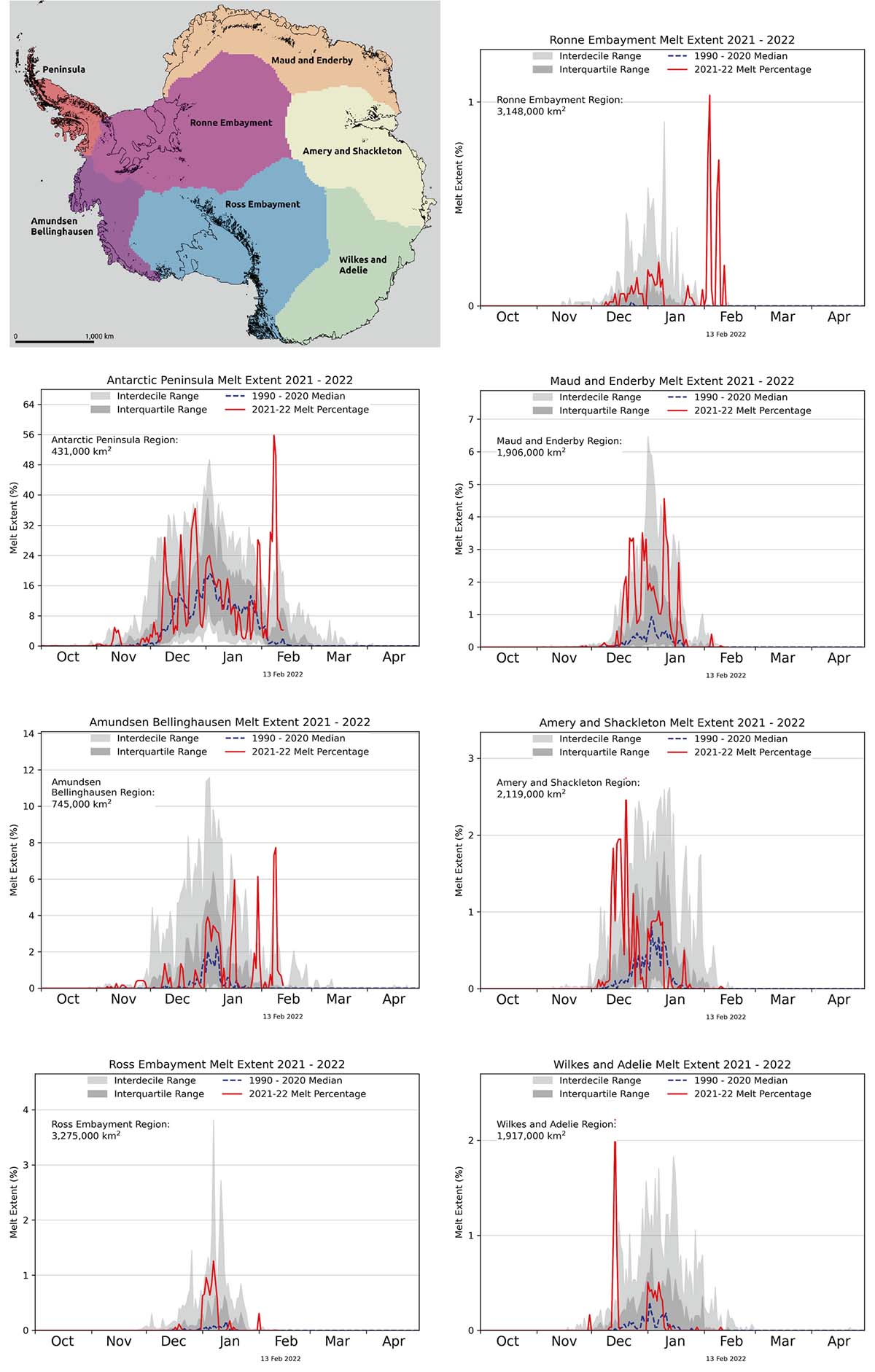
The image below credits L. Lopez, NSIDC, M. MacFerrin, CIRES, and T. Mote, University of Georgia show regional daily melt extent for seven Antarctic regions. Surface melting was limited to near-coastal areas everywhere except the Antarctic Peninsula this year.
In the Amundsen Bellinghausen, Antarctic Peninsula, and Ronne Embayment is noticeable how the synoptic pattern produced such an intense melt event in terms of the extent involved.
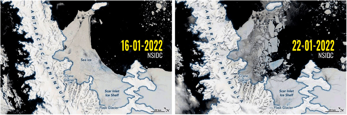
As a consequence of all these events, multiyear fast ice in the Larsen B embayment, in place continuously since early 2011, showed widespread meltwater flooding with some deeper ponds and some areas drained by narrow fractures. Between January 16 and the 21st, the ice of the Larsen B ice shelf, linked to the Antarctic Peninsula, crumbled and disintegrated.
It is often emphasized that the melting of ice shelves does not actually contribute to sea-level rise because ice shelves are buoyant and already displace water. This is not actually completely true, because ice shelf melting produces freshwater, which has a lower density than salty seawater.
This means that the volume of seawater displaced by an ice shelf is less than the volume occupied by the same mass of freshwater. The volume difference is around 2.6%, and it has been calculated that if all existent sea ice and ice shelves melt, the average global sea level would rise by roughly 4 centimeters.
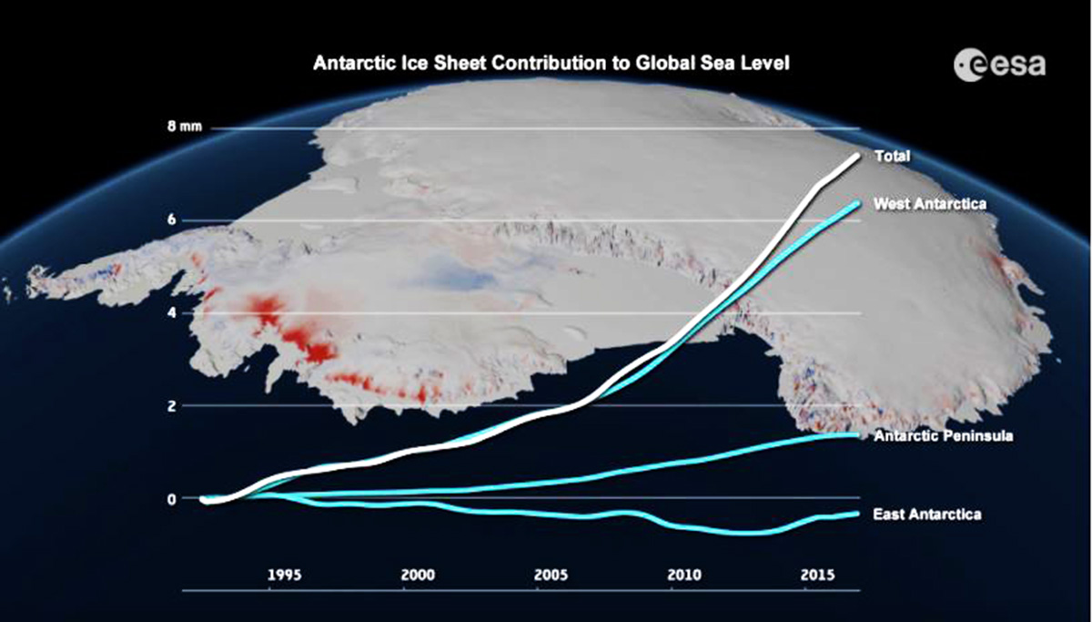
If all the ice in the West Antarctic Ice Sheet should melt, the global sea level would rise by 3.2 m.
The Antarctic Peninsula Ice Sheet would contribute 0.24 m or 0.79 feet to global sea-level rise on full melting, and currently contributes 0.22±0.16 millimeters or 0.009±0.6 inches per annum. The East Antarctic Ice Sheet has a sea-level equivalent of approximately 60 meters or about 197 feet.
Both the Arctic and Antarctic Ice extent in the sea pushes the global anomaly at -2.244 million square kilometers or about 0.720 million square miles. In the image below the current ice pack anomalies for the Arctic and Antarctic, source NSIDC, DMSP SSM/I-SSMIS F-18 edited by Zachari Labe. Anomaly is based on 1981-2010 climatology

We will keep you updated on this and much more, so make sure to bookmark our page. Also, if you have seen this article in the Google App (Discover) feed or social media, click the like button (♥) to see more of our forecasts and our latest articles on weather and nature in general.
See also: