The meteorological spring and the new tornado season in the United States are here. This year, a finally decaying La Nina could lead to increased severe weather events and well-above-average tornado activity again. The coming week will bring potentially dangerous severe weather and tornado outbreaks for the South and Southeast parts of the country.
The meteorological spring has started about three weeks ago, and Monday marks the official start of the astronomical spring season 2022. This means the main focus for the upcoming few months will be the tornado season in the United States. Similar to last year, still colder than normal Pacific waters are present, with a decaying La Nina global circulation, which has an effect on the patterns across North America as well.
During the La Nina and especially when it is transitioning into a neutral phase, the potential for increased severe weather events and above-average tornado activity is in place. The recent winter season was pretty active and cold, but it did not delay the tornado activity at all. We can just remember deadly twisters in Iowa a few weeks ago, with a historic winter tornado outbreak. Soon, the thunderstorm activity will ramp up.
The recent weather model guidance is confirming a quite high probability for a robust weather system developing across a large region of the central and southern United States from Monday through Wednesday. It will deliver spring snow on the northern side and severe thunderstorms farther south.
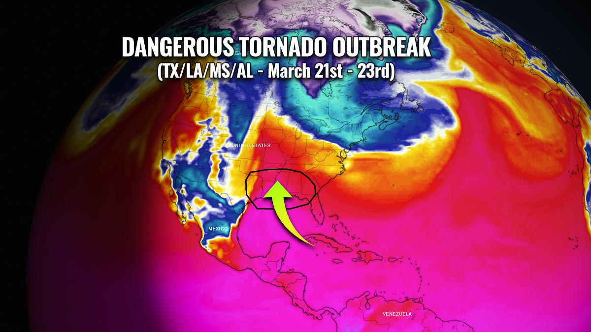
It seems that the severe thunderstorm activity is following the statistics pretty well this spring with soon catching up with the long-term activity. The coming week’s forecast calls for a potentially dangerous severe weather and tornado outbreak with a significant threat across the South and the Southeast United States. Odds are growing for a tornado outbreak to develop as a strong surface depression with a frontal system rips across the central U.S., moving into the Dixie Alley with areas from Eastern Texas across Louisiana, Mississippi, and Alabama in the prime zone.
So far this year and spring season, we are seeing a quite active start of the tornado activity, with about 20% off of a normal year. As we saw, the severe weather activity has started earlier than usual, especially if compared to the recent years. And what the weather models are trending again this year, tornado season could be well above-average for the spring season 2022.
The above-normal seawater temperatures over the Gulf of Mexico and Caribbean region play a very important role every year, as they provide moist air mass as the fuel for the storms. Together with the jet stream, the strong winds in the upper-level parts of the atmosphere. A combination of very moist and warm lowest levels of the atmosphere and the strong jet stream aloft, bring these ingredients together and the result is organized severe thunderstorms, including tornadoes.
Severe thunderstorms and tornadoes can happen at any time of the year, but the ingredients for the most dangerous storms and damaging twisters come together most frequently in the central and southern U.S. during March, April, and May. This is why meteorologists consider these spring months to be severe weather or tornado season.
Let’s quickly go through the most important factors as their understanding is crucial for the forecasting of severe weather events.
TWO MAIN INGREDIENTS: INSTABILITY AND WIND SHEAR
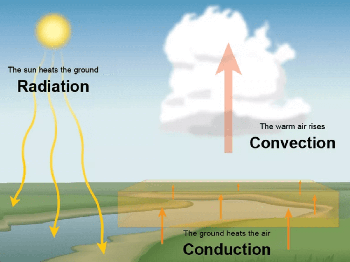
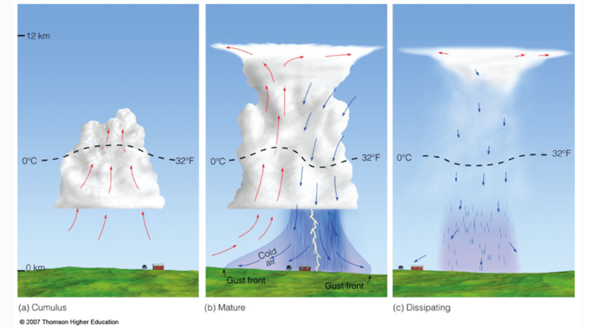
A thunderstorm forms when surface heating results in upward rising warm and moist air mass. This typically occurs along some kind of the existing frontal boundary (e.g. cold front, dryline, etc.), or mountain ranges for example. When air parcels are rising, the air condenses and creates precipitation. Once you hear thunder and lightning, a thunderstorm has been born.
When a more robust environment is in place, the ingredients result in more volatile storms, leading to potentially dangerous severe weather events. That is when severe thunderstorms come into play. The most dangerous storms are supercell thunderstorms. They are the most severe type of thunderstorm and often lead to flooding, very large to giant hail, winds, and damaging tornadoes.
There are two main ingredients that determine the type or intensity of the potential severe weather (thunderstorms). Those are the available energy, known as instability, and the winds. Both low-level and upper-level winds have different speed and direction that leads to wind shear. A combination of both winds and instability then brings severe thunderstorms.
To simplify things: the higher the instability and wind shear are, the more robust and dangerous thunderstorms could develop.
Strong or Extreme instability
When we mention the unstable air mass or instability, we have in mind the potentially convectively available potential energy (or short: CAPE) the environment contains to fuel the storms. The more energy has accumulated in the air, the more vigorous convection and storms will develop. Sometimes, when huge amounts of energy are present, the explosive development of storms will follow. CAPE could be from 1000 to more than 6000 J/kg on the most extreme events.
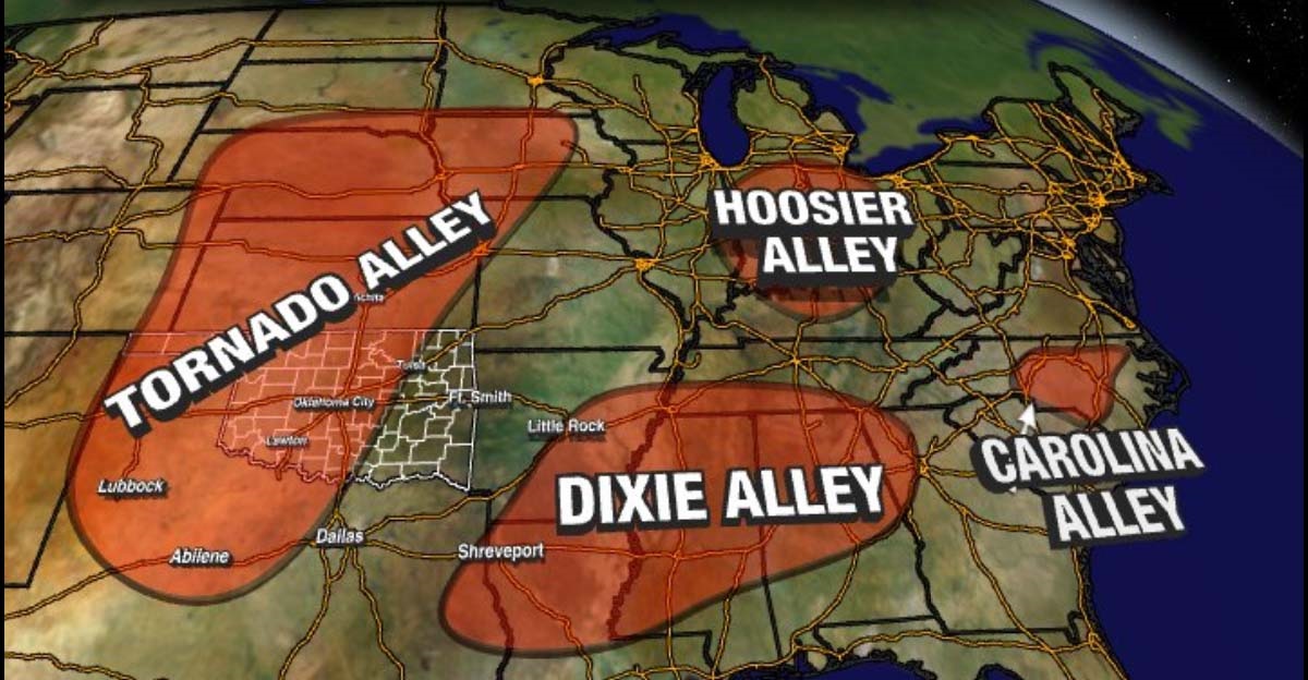
This is when we look at the seawater temperatures of the Gulf of Mexico, as the majority of the moisture comes from it during the spring season in the U.S. This is the important factor and has a direct influence on the tornado season activity across the South and Southeast parts of the U.S. as much higher energy building up in March and April. This infamous region is also known as the Dixie Alley and has seen numerous destructive tornado outbreaks in the past.
So, the source of a very moist air mass actually comes from the deep south tropical region, as far as from the Caribbean Sea region. The following chart reveals that the sea surface temperatures are about 1-2 degrees Celsius above the average. The higher the waters are, the higher moisture (dewpoints) are present.
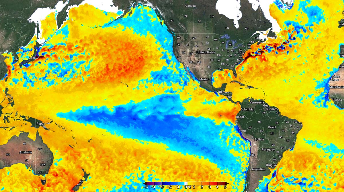
This is an important signal to monitor for the tornado season this spring, as the high moisture is then gradually spread into the United States mainland from March into April, and increases through May and June farther north across the Great Plains and Midwest. This tells us that the energy could get very high once the stronger warming starts during April.
So to repeat: The higher the moisture and temperature are present in the environment, the higher energy will accumulate. In other words, this means that there is a higher potential for more robust convection and severe type of thunderstorms during the spring season.
Jet stream and wind shear
The second, an also very important ingredient needed for thunderstorms to get going and organize, is the wind throughout the whole atmosphere. From the low-levels to the upper-level parts. Winds are the strongest in the higher levels and are known as the jet stream.
The jet stream is a result of a temperature difference between the large-scale systems in the upper levels of the troposphere we live in. Therefore we know that the stronger the systems are, the stronger the jet stream will be. Wind speed is increasing with height and also its direction is different, this is known as the wind shear.
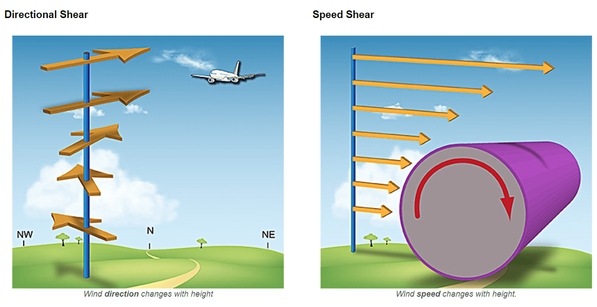
So, wind shear is, besides instability, a very important key ingredient for severe thunderstorm environments. Changing wind with height leads to a rotating updraft tower of a thunderstorm, helping them to sustain and live longer. Those are known as the supercell thunderstorms.
Every year, as the cold winter transitions into the spring season, these upper-level winds begin their typical retreat towards the north. In 2022, the jet stream is stronger than usual due to the effect of the decaying La Nina. This is also amplifying the winds closer to the ground, which helps to pump the fuel for storms – moist and very warm air mass – from the Gulf of Mexico to the north.
The chart above indicates the typical late winter/early spring season climatological activity of the severe weather across the United States. With the jet stream amplified over the country, the highest frequency of severe weather events across the South and the Southeast United States typically increase.
According to the studies of the tornado events environment across the Tornado and Dixie Alley, these upper-level winds tend to be stronger in the early spring season. March and April tend to deliver more tornadoes when the Pacific waters are colder than normal. This is why it is important to study global patterns and their important role in predictions of what to expect during a tornado season this spring.
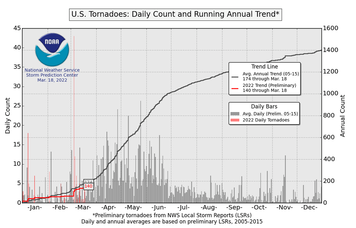
2022 TORNADO SEASON NEAR NORMAL SO FAR
As of this weekend, March 18th, there were 140 tornadoes preliminary reported across the United States so far. An average year delivers around ~170 tornado reports from Jan 1st through mid-March, so 2022 tornado season is not too far off these, running at around 80% of the long-term normal this spring.
This indeed does not mean the season could continue to see below-normal activity, as the general spring season predictions hint at an above-average activity. This year, La Nina is coming into its final weakening in the upcoming months, which normally leads to increased severe weather events and above-average tornado activity from March to June.
Thanks to the still below-average sea temperature across the tropical central Pacific waters, this spring season could trigger an above-average number of tornadoes with statistics likely catching up pretty quickly in the coming weeks. Compared to recent years, the forecast conditions seem to be favorable for higher tornado counts.

The chart above is the most recent ENSO forecast for the central Pacific ocean water temperatures. Both infamous Tornado Alley and the Dixie Alley tend to get more dangerous severe weather with a higher potential for tornado outbreaks to happen when cooler Pacific waters are present. Especially as La Nina tends to deliver a higher probability for tornado outbreaks when a single day or event could produce numerous dangerous twisters.
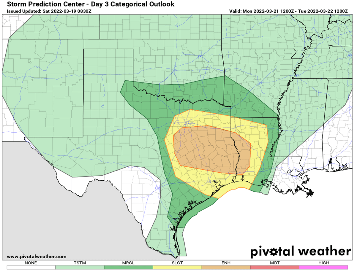
DANGEROUS SEVERE WEATHER WITH TORNADO OUTBREAK FOR TEXAS AND LOUISIANA ON MONDAY
On Monday this week, the general weather pattern across the United States will begin rapidly changing with a deep upper wave emerging into the southwestern portions of the country. The low will be deepening further while moving towards the southern Plains. With the strong upper High placed across the eastern half of the U.S., ample moisture and warm air will begin spreading northwards across the western Gulf Coast.
When an upper wave emerges across the southern Rockies from the west as this time, it leads to a very fast moisture recovery across Texas and Louisiana. The associated frontal wave and front will therefore bump into very warm and moist air from the Gulf of Mexico, leading to severe weather developing.
A strong warm and moist advection associated with the southerly winds will support elevated thunderstorms across central Texas and Oklahoma through the Monday morning hours. With the persistent southerlies advecting high Gulf moisture northward, a gradual increase of thunderstorm activity is expected during the day.
By afternoon, the potential for thunderstorm development will be most likely near advancing dryline across central Texas.
While the increasing flow with height, combined with substantial veering through the lowest 3 km, will provide ample shear favorable for supercells.
Storms will have the potential for large hail across central Texas, while the risk for tornadoes should increase through the afternoon farther east.
Through the evening and the overnight hours, the favorably unstable airmass will expand eastward across the Sabine River into Louisiana with very strong shear remaining in place.
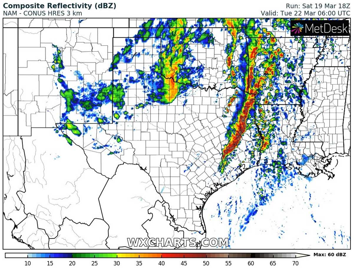
This will increase the risk for tornadoes where a couple of them may be strong, especially across East Texas and into Louisiana through Monday night.
SEVERE WEATHER WITH TORNADO THREAT LIKELY TO CONTINUE INTO MISSISSIPPI AND ALABAMA ON TUESDAY
There is a potential for another widespread severe weather and a tornado outbreak again across portions of the Dixie Alley also the day after.
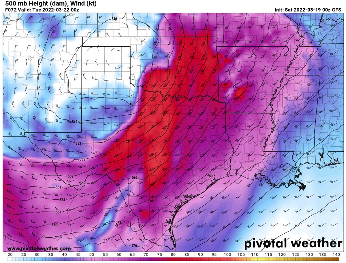
The upper wave disturbance will be deepening while emerging farther east across the central United States on Tuesday into Wednesday. Its deep core hints that it means a serious threat once the frontal system taps deeper into the very warm and moist air mass across the deep South U.S. Severe storms will continue and intensify again on Tuesday afternoon and evening.

The main reason for the enhanced chance of a large tornado outbreak is in the very strong jet stream that develops aloft. It is associated with the deepening upper-core moving east, and it couples with unstable air mass beneath.
Powerful upper-level winds will round the core of the upper low, providing a very favorable source of a lifting mechanism for thunderstorms to keep going and expand in coverage on Tuesday into Wednesday.
Very intense wind speeds within the jet stream (100-130 knots) will bring the wind shear very high, creating a rather volatile environment for storms that will form in these conditions. Normally these also support tornadic storms development.
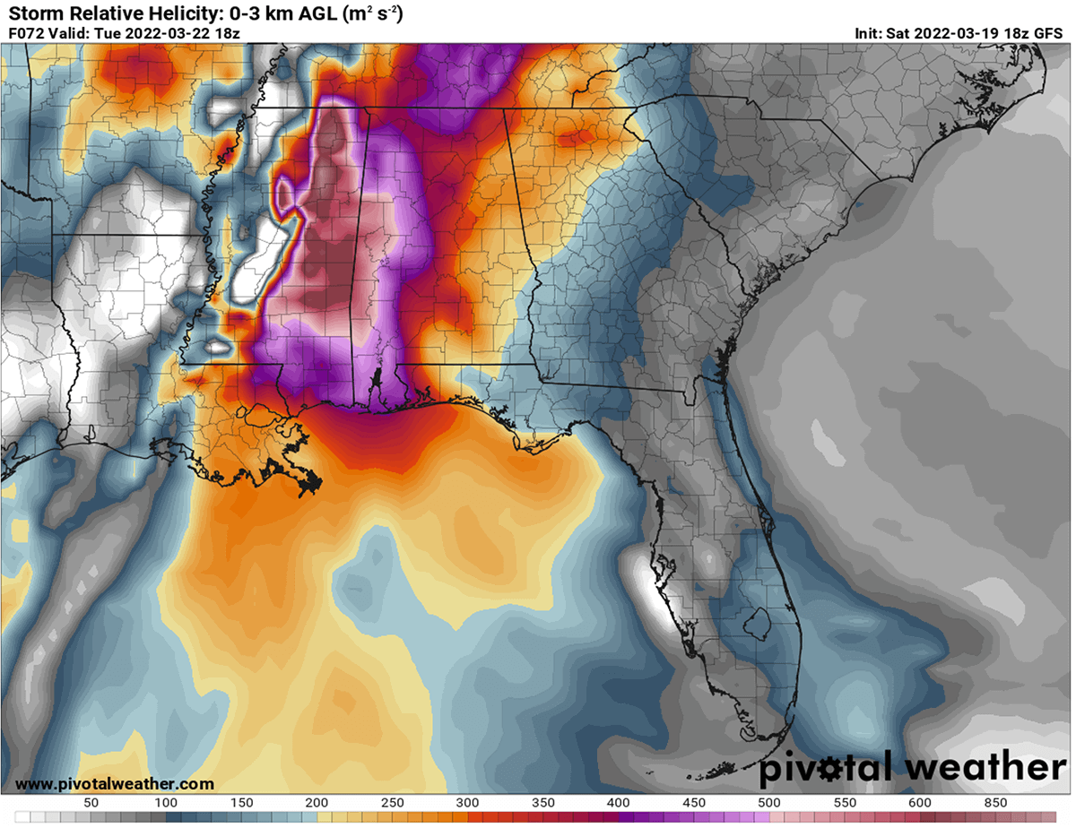
Attached below is the Storm Relative Helicity chart (SREH), a measure of the amount of wind shear available from the ground into the lowest levels of the atmosphere. When values are greater than 250 m^2/s^2, this suggests an increased threat of supercells and tornadoes. These are some impressive and very concerning numbers that could mean the very high potential for even strong tornadoes.
The advection of high moisture (surface dewpoints averaging in the upper 60s) northward from the Gulf of Mexico into the pre-frontal warm sector spread across Louisiana, Mississippi, and central Alabama. A high-end environment for dangerous twisters appears likely to exist across the area centered over the central Gulf Coast states, supporting the potential for a substantial outbreak of severe thunderstorms and tornadoes.
The tornado threat should be maximized across eastern Louisiana and central Mississippi during the afternoon hours, and then later increasing eastward into Alabama. These conditions are undoubtedly a great concern and could lead to a dangerous tornado outbreak across part of Mississippi, Alabama on Tuesday. Besides a high chance for tornadoes, severe damaging winds and especially significant flooding will occur.
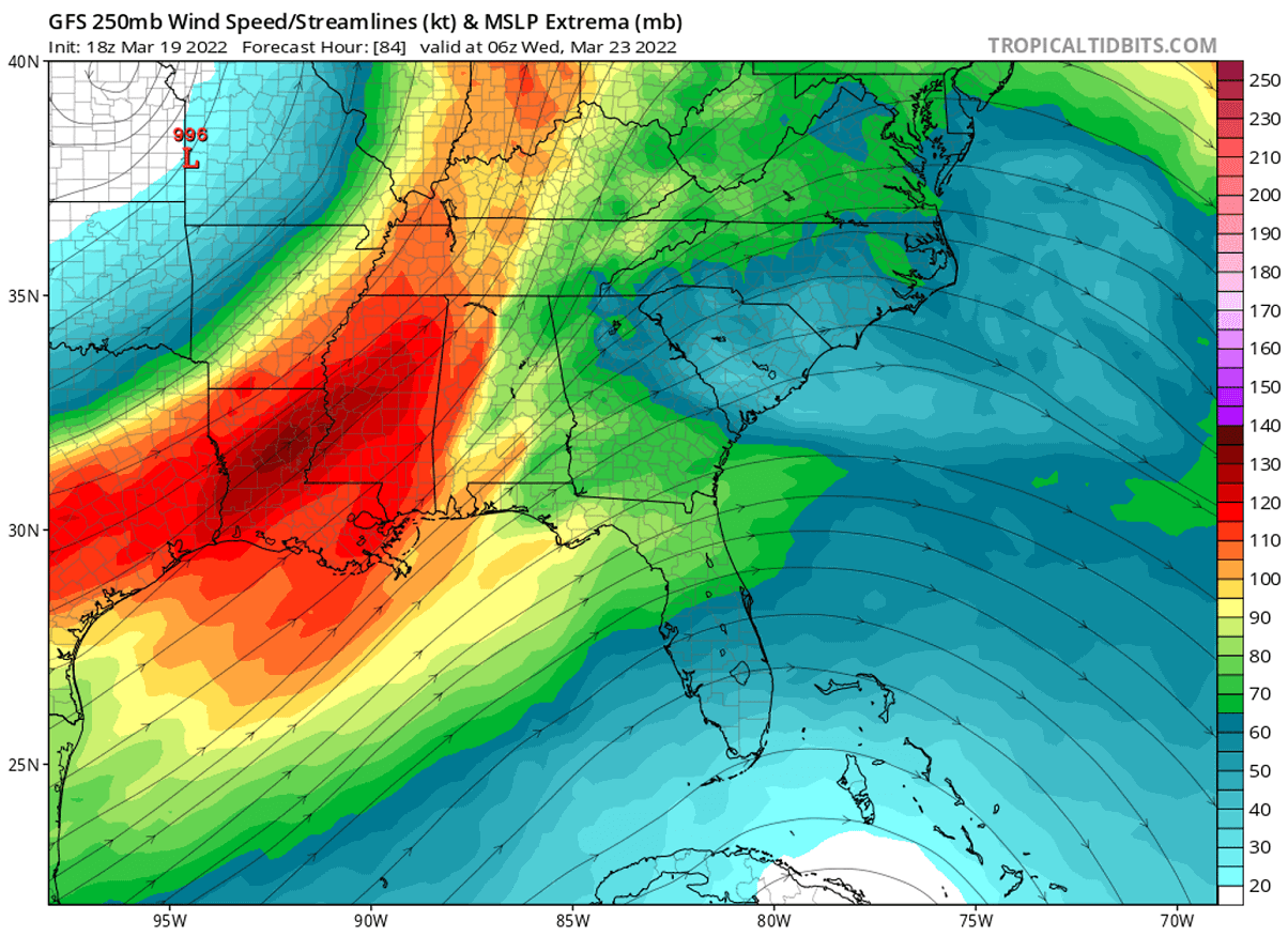
Severe weather potential will likely continue into Wednesday, though the upper wave appears likely to become somewhat elongated as the upper low shift northeastward across the Ohio Valley. Thus, an amply moist and unstable environment and still-strong shear will exist across southeastern Alabama, southwestern Georgia, the Florida Panhandle, and parts of South Carolina. Supporting continued potential for severe storms, including a few tornadoes again.
It is important for you to tune in and follow your local National Weather Office for the latest updates and warning details once storms develop on Tuesday.
ABOVE-AVERAGE SEVERE WEATHER TORNADO ACTIVITY LIKELY THIS SPRING SEASON
When the spring season arrives in the United States, the warming increases from south to north. The moist air from the Gulf of Mexico is gradually becoming unstable as it mixes with warming land to the north. If we think of the still existing La Nina which normally boosts the activity, we do have a general idea of what could be coming up ahead for the tornado season. It is obviously not that simple, of course, but we are likely going to bump into a very tornado-active spring season this year.
Similar to the season 2021, the main activity this year might again be shifted farther east than usual, into the low-mid Mississippi Valley and the central Gulf Coast. This indeed does not mean the traditional Tornado Alley will see much fewer tornadoes but the activity might keep the numbers below average to some degree.
The southern and central United States into the Midwest should still hold an annual highest frequency of severe weather hazards and tornadoes.
The Southeast United States region, best known as the Dixie Alley, has delivered some historic and pretty deadly tornado outbreak events in the past. And it is mostly a very unfriendly area for the local residents when tornadoes occur. The Mississippi Valley is full of trees and high humidity most of the time, so tornadoes are even more dangerous and hard to spot, as residents have a lack good visibility compared to those living on the flat open fields of the Great Plains.
With the gradually retreating upper-level winds with the strong temperature contrast beneath, the south-central states around the Mississippi river up towards the Tennessee valleys and east to Alabama might be in higher threat through the end of April. Then, the general shift towards the traditional Tornado Alley should follow.
The overall strong jet stream pattern will likely continue and extend into May, so the tornado season will keep storm chasers across the country quite busy again this year.
*** The images used in this article were provided by Wxcharts, PivotalWeather, and Windy.