An unprecedented record cold has spread across the southern US, driven by the deep Polar Vortex lobe aloft. A major snowstorm hit Texas and Oklahoma, now spreading east across the Mississippi Valley into the Southeast United States, significant freezing rain is expected. Deep snow further north across the Ohio Valley by Tuesday night. More than 150 million Americans remain under winter storm warnings.
Locally heavy snow, sleet, and freezing rain blasted the southern Plains while the winter storms continue east across the Mississippi Valley into the Ohio Valley tonight. A major snowstorm is expected. Along the southern edge of the deep snowpack forecast, dangerous freezing rain is likely to develop. Significantly disturbing the traffic tonight through Tuesday Night.
More than 150 million Americans are currently still under Winter Storm Warnings, Ice Storm Warnings, Winter Storm Watches, or Winter Weather Advisories as impactful winter weather continues from coast-to-coast. With a major winter storm forecast to spread heavy snow and significant ice accumulations from the Southern Plains and Ohio Valley to the Northeast.
An extensive Arctic high will continue to cause bitterly cold temperatures across much of the CONUS through early this week, and widespread winter weather is forecast along its periphery. The system has brought some extremely cold, even record-breaking low temperatures and snow into deep south Texas.
Frigid Arctic air and dangerously cold wind chills are expected to persist in the Heartland through a good part of the week. In addition, severe thunderstorms, heavy rain, and warm temperatures are expected for southern Georgia and Florida.
The main reason and the driver behind this historic cold outbreak is the Polar Vortex spinning above the North Pole. Thanks to its collapse, we are now seeing a life-threatening and record-breaking cold across the nation.
Check the warning chart above again; not often you see such a large part of the nation covered in warnings for dangerous weather. The entire states of Texas, Oklahoma, and Arkansas were under Winter Storm Warning on Sunday night.
The whole area within the active Winter Storm Warnings was an astonishing 1.6 million km^2, setting a new record. The previous 1-day area coverage with this type of warning was Feb 1st in 2011, with about 1.2 million km^2 of warnings.
IT ALL BEGAN IN EARLY JANUARY AS POLAR VORTEX COLLAPSED
Some very dynamic weather patterns were ongoing across the North American continent over the last few weeks, from mid-January and literally escalated to the edge in early February. Blame it on the Polar Vortex collapse which has occurred in early January. After the Sudden Stratospheric Warming event causing this collapse, the dominant feature was the high-pressure system over the Arctic region becoming very strong over Greenland.
Earlier, prior to the Polar Vortex collapse, December was milder than normal across North America, especially over Canada. Such pattern also continued into the first half of January, as it normally takes a few weeks to show the effects of the Polar Vortex disruptions. Most of the continent was warmer than normal, being the warmest across eastern Canada under the high-pressure system from Greenland.
The stratospheric warming wave has moved across the entire North Pole in the stratosphere, effectively splitting the cold-core of the Polar Vortex into two parts. One part of the broken Polar Vortex was pushed over North American and one part over the European side.
The blocking High over the Arctic/Polar region moved further towards the polar circle, turning the very cold pool deeper towards the south across into the North American continent. And really escalated through early February and it now continues into the mid-month. A historic and frigid cold outbreak is underway for a large part of the United States.
RECORD-BREAKING COLD AND SNOW FOR THE SOUTH
Thanks to the side effects of the Polar Vortex collapse aloft, weather systems came with an extreme, record-breaking bang for this mid-February. Extremely cold, frigid Arctic air mass spread from Canada into the United States with temperatures even below -40 °F across the north with life-threatening wind chills reaching down to -60 °F near the International border with Canada over the weekend.
Temperatures were screaming into deep lows also farther south and were down significantly across Texas and Oklahoma this Monday morning. The extreme, frigid cold has spread across a large part of the nation with temperatures below zero °F as far south as West Texas, south Oklahoma, and northern Arkansas. Brutally cold -25 to -35 °F across Nebraska and Minnesota.
With the remaining northerly winds, windchills were even lower in all these states and hitting some remarkable values down the Gulf Coast. Near 0 °F windchill was observed just along the coast of Texas, with snowfall and freezing rain/sleet reported between Brownsville and Houston as well today.
The snowstorm beginning on Sunday has also set some unprecedented records across Texas, according to the local National Weather Service of the state. Both San Angelo and Abilene got their all-time snow records broken. The cities received 10.1 inches and 14.8 inches respectively on Sunday.
San Angelo has broken its previous record of 10.0 inches (from Jan 16th, 1919) while Abilene reported 14.8 inches and broke its previous record of 9.3 inches (from Apr 5h, 1996).
San Angelo also set its record for the lowest and highest temperature, while Abilene tied its record low temperature on Valentine’s Day.
Here is an impressive visible satellite image across the southern Plains this Monday. The snow cover can be seen almost at the Gulf Coast. With indeed much deeper snowpack further north across Texas and Oklahoma into central Plains.
Across Kansas, Colorado, and Nebraska, numerous daily low-temperature records were smashed this Monday morning. -26F was recorded in Colby (KS), -27F in Yuma (CO), -24F in Burlington (CO), -23F in Goodland (KS), and -22F in McCook (NE).
Dodge City (KS) broke its 140 years old Feb 15th record today, it was -14F. Breaking the previous record of -10F set in 1881!
The Grand Island airport (NE) broke its 126 years record this Monday, Feb 15th. It was -23F this morning, breaking its previous record of -18F set in 1895! Hastings municipal airport (NE) hit -26F and set a new February record after more than 100 years, breaking the previous record of -22F from 1917.
The city of Midland, West Texas has had 5 inches of snow on Valentine’s Day. That is the first time ever recording more than a trace of snow of Feb 14th.
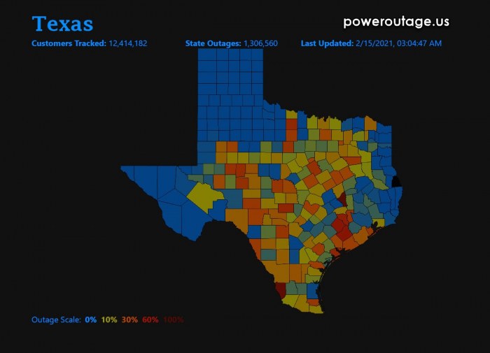
The freezing rain and extreme cold (windchill) which hit southern portions of Texas also brought major power outages for Texans. More than 2 million people were without power this Monday Monday, thanks to dozens of frozen wind turbines. These wind farms in the western and northern parts of Texas had its oil for the hydraulic systems for the turbines freezing.
The second reason was the gas delivery from the region as pumps couldn’t follow up to provide the important gas for heating systems across the nation. Due to this heating demand, the electric companies were making power rollouts from time to time. That is to avoid the complete overload of the electrical system.
WINTER STORM CONTINUES INTO SOUTHEAST AND OHIO VALLEY
An unprecedented and expansive area of hazardous winter weather continues this Monday as disruptive snow and ice accumulations transpire across the South Central U.S. early this morning. This impressive onslaught of wicked wintry weather across much of the Lower-48 is due to the combination of strong Arctic high pressure supplying sub-freezing temperatures and an active storm track escorting waves of precipitation
from coast-to-coast.
While the current areas of snow and wintry mix over parts of the Southern Plains will conclude this evening, bitterly cold temperatures will limit the amount of melting, and thus treacherous travel conditions are likely to persist.
Heavy snow and freezing rain are forecast to advance northeastward today from the Mississippi and Ohio Valleys to the Northeast tonight into Tuesday.
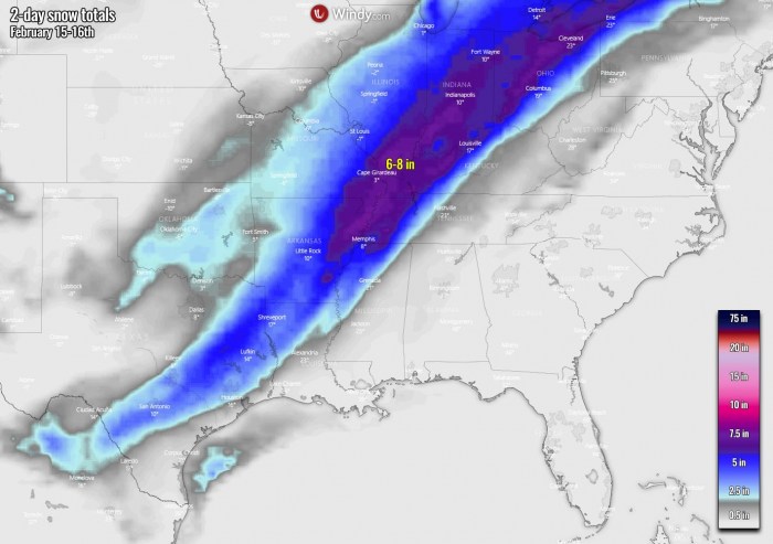
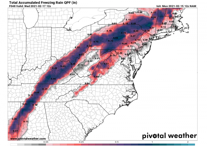
A large swath of 6 to 12 inches of snow is forecast from the Ohio Valley and eastern Great Lakes to northern New England. South of the heavy snow axis, freezing rain is expected to cause a plethora of problems with over a tenth of an inch of ice in the forecast from far east Texas northeastward to southern New England.
Significant ice amounts of a quarter to a half-inch are expected in portions of the Lower Mississippi Valley and the Mid-South leading to dangerous travel conditions, numerous power outages, and extensive tree damage. Precipitation will likely stay rain for the southern Mid-Atlantic and Southeast where cold air is more limited.
Some extreme amounts of ice are forecast from southeast Texas to Arkansas and towards southern Illinois.
Even close to around an inch (0.8-1.0″ or 2-2.5 cm) of accumulated ice will be possible from northern Alabama across central Kentucky and Tennessee into southern Ohio and across Pennsylvania to New York State into the Northeast United States.
That could be damaging for the trees and could lead to significant power outages and traffic issues. Especially as temperatures will remain very low where salting will not be that effective anymore. Bridges will freeze first.
The Arctic high-pressure system across the central United States is forecast to slowly moderate as the week progresses, but still, maintain a firm and icy grip over the Heartland to open the week.
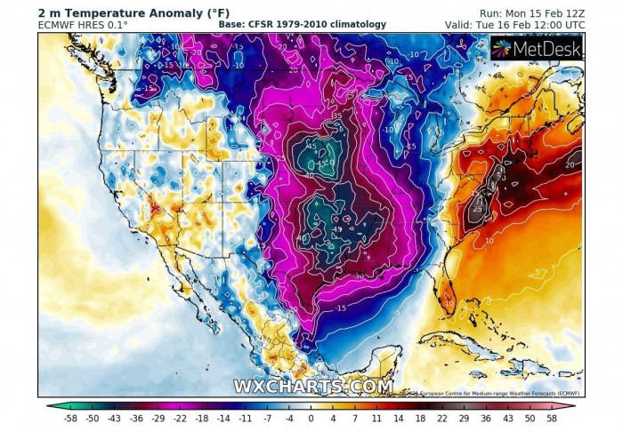
Teeth-chattering cold temperatures are expected to continue between the Rockies and Appalachians through Tuesday with lows in the -20s and -10s for the Northern/Central Plains and Upper/Middle Mississippi Valley.
Temperature anomalies are likely to be 30 to nearly 50 degrees below normal for much of the central and southern Plains tonight with a carbon-copy of similar anomalies expected again on Tuesday.
In addition, Wind Chill Warnings and Advisories reach as far south as the Southern Plains and as far east as the Ohio Valley. Hundreds of daily low maximum and minimum temperatures have been/will be broken during this prolonged ‘polar plunge’, with some February and even all-time low-temperature records in jeopardy.
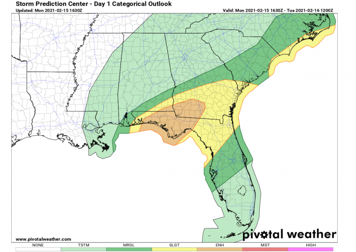
Meanwhile, showers and thunderstorms are ongoing across parts of the Southeast near and along a stationary front. Severe thunderstorms are in
the forecast today in southern Georgia and into the Florida peninsula where a Slight Risk of severe weather is in place courtesy of the Storm
Prediction Center.
TORNADOES POSSIBLE ACROSS FLORIDA PANHANDLE
According to the SPC, an ENHANCED RISK of severe storms has been issued across Florida Panhandle into southwest Georgia tonight with severe thunderstorms also possible across the SLIGHT RISK area along the Carolinas overnight into Tuesday morning.
Scattered damaging winds and a few tornadoes are likely across the Florida Panhandle into south Georgia through early evening. A strong tornado or two is possible. Severe thunderstorms are also possible across north Florida and overnight into the coastal Carolinas.
Here is the SPC’s forecast convective discussion regarding the potential threat tonight:
…FL Panhandle to south GA…
Upgraded to cat 3/ENH risk for the potential of a strong tornado or two along with scattered damaging winds likely, a few of which may be significant.
Scattered thunderstorms are underway from the surface cyclone that is near the far southeast tip of LA into the north-central Gulf along a sharp cold front. Additional convection may also develop within the next couple hours ahead of this activity within pre-frontal bands of confluence evident in visible satellite imagery.
As the surface cyclone deepens towards the AL/GA/FL border area, the warm front should advance inland across the FL Panhandle reaching southern GA by early evening. Mid to upper 60s F surface dew points are expected in that regime, supporting a pronounced gradient of MLCAPE from north to south, approaching 1500 J/kg along the coast.
Expect strengthening mid/upper winds supporting 50-65-kt southwesterly effective-shear vectors, oriented just slightly rightward of the main corridor of convective forcing with an elongated mid/upper-level portion of the hodograph. The southern fringe of a 45-60-kt LLJ will contribute to low-level hodograph curvature with 200-400 m2/s2 effective SRH, greatest along the warm front.
ANOTHER SNOW AND ICE STORM COMING UP ON THURSDAY
There seems to be no end to this historic winter weather this month. Yet another, potentially even very significant winter storm is expected to hit the South, the Lower Mississippi Valley, the Southeast and East Coast of the United States on Thursday into Friday.
What the weather models are hinting at is the potential for another wintery blast from Texas across Arkansas into Louisiana, Mississippi, Alabama, and towards the Lower Ohio Valley on Thursday. And intensifying while drifting towards the Mid-Atlantic Region and the Northeast into Friday.
Attached below is the snow totals chart for the next 10 days across the eastern half of the nation. We can see that a huge amount of snow is expected. Thanks to the ongoing frontal system tonight into Tuesday and especially with the new front arriving on Thursday.
Locally more than 15 inches of snow will likely be accumulated by early next week. Even more in some areas, especially along the lakes where lake-effect snow will develop in the coming days. Especially are frigid cold air mass turns towards the Northeast and winds turn westerly across the Great Lakes region.
***The images used in this article were provided by Windy, PivotalWeather, and WXCHARTS.


