A Category 5 Chanthu is grazing across the Philippines Sea this week, a 2nd Super Typhoon of the Western Pacific season 2021. It is now past its peak but remains a powerful typhoon while moving towards the northeastern tip of Luzon island this Friday. Then, a potentially significant impact is increasingly likely to eastern Taiwan on Sunday as a typhoon nears the country and brings damaging winds, major storm surge, torrential rains, and flooding.
Super Typhoon Chanthu has reached its peak intensity as a Category 5 on Wednesday. It lasted only 48 hours for the system from being designated as a tropical depression in the Northwest Pacific to a monster Category 5. Chanthu was undergoing an explosive/rapid intensification to 160 mph winds on Wednesday afternoon local Philippines time. The other Category 5 in the region was Super Typhoon Surigae back in April this year.
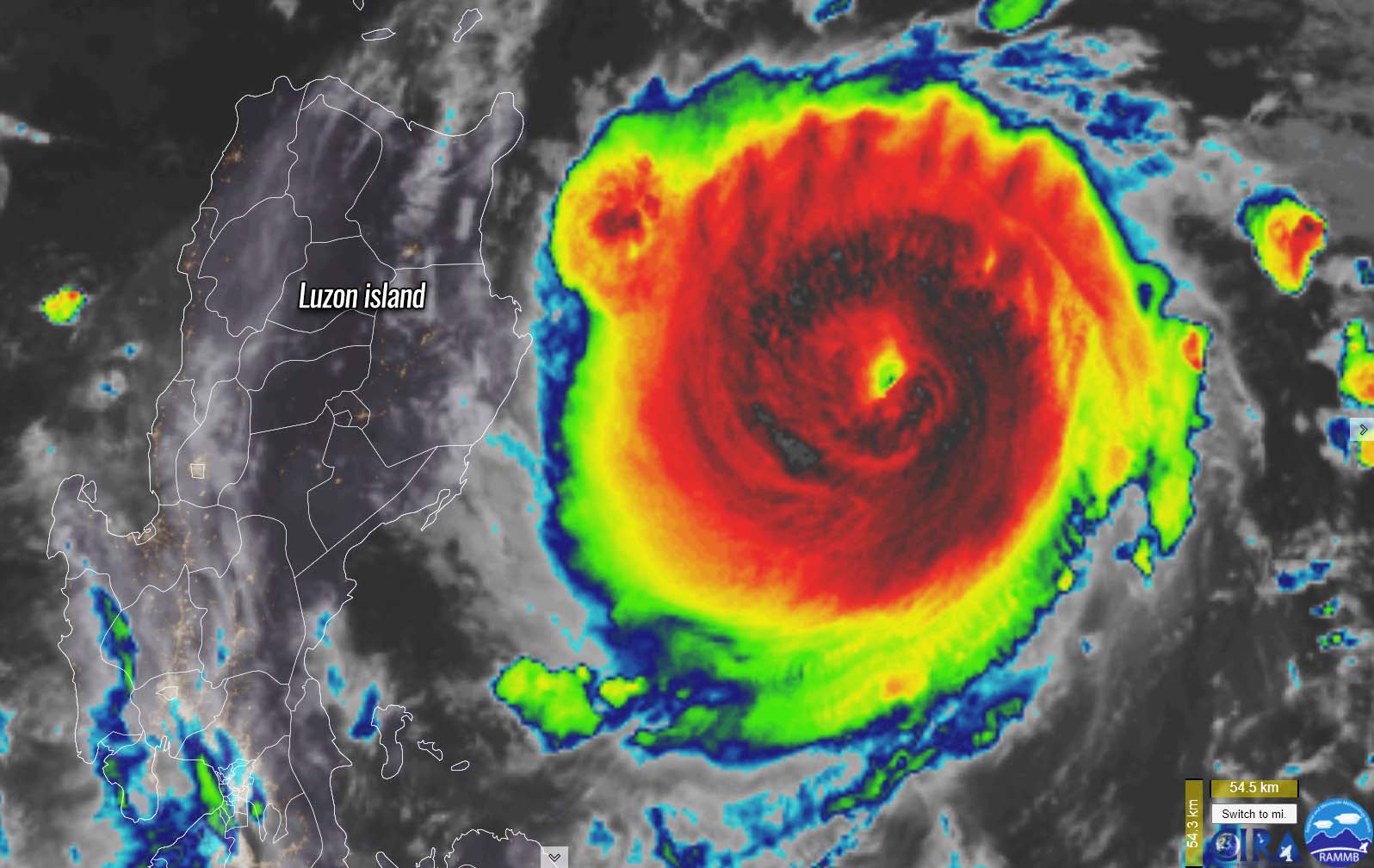
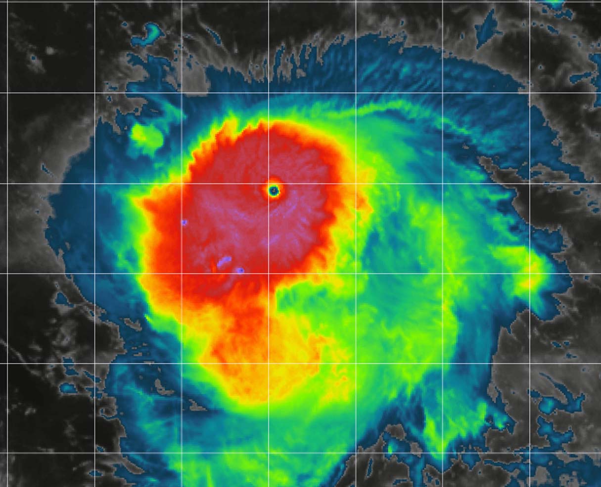
Typhoon Chanthu is actually a relatively small tropical cyclone and had a tiny pinhole eye during its extremely fast strengthening. This is often the case when we have small tropical cyclones being able to achieve very rapid pressure/wind intensity changes, also in quite a short period of time. The eye of Chanthu was only about 5-6 miles in diameter.
After its peak intensity of 160 mph winds on Wednesday, Chanthu has weakened a bit due to an EyeWall Replacement Cycle (EWRC) where its inner eyewall collapsed and was gradually replaced by a larger eyewall (outer). So its eye is now larger which is quite a typical process during the lifetime of the most powerful tropical cyclones.
On Thursday, Chanthu was downgraded back to a Category 4 Super Typhoon strength, having 155 mph winds, moving west towards Luzon island, Philippines. The typhoon is forecast to travel near the island on Friday but is unlikely to make a direct impact or landfall. Thanks to the rather small size of the winds of Chanthu, it is crucial how close to the coast its eyewall moves, so the most intense winds will likely miss it, although it will remain a monster Category 4 storm over the sea.
Over the weekend, Chanthu is forecast to continue gradually weakening, but remaining powerful typhoon until it nears the coast of Taiwan and makes landfall sometime on Sunday, possibly as a Super Typhoon strength. Where exactly and how intense the landfall impact will be, is yet to be defined. Nevertheless, the whole eastern coast is in the potentially damaging winds/rain threat this weekend.
Note, that the main driver behind these explosive tropical cyclone formations is very often the extremely warm sea waters and the wave known as a Madden-Jullian Oscillation (MJO). During the MJO wave, the environmental conditions are strongly supportive of explosive and powerful typhoons in the Western Pacific region.
CHANTHU FORMS IN VERY WARM PACIFIC OCEAN WATERS AND A MAJOR MJO WAVE ALOFT
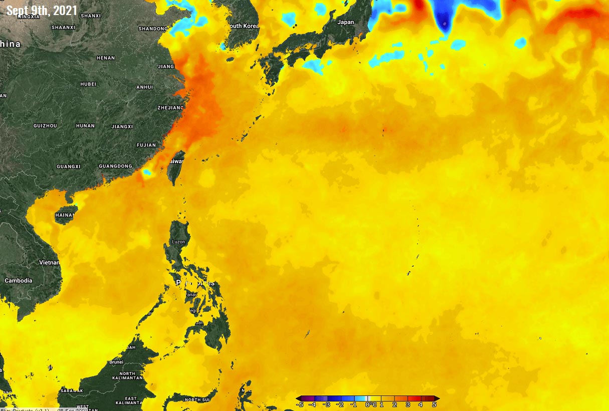
The Western Pacific water surface temperatures have significantly warmed up in recent weeks. Those are even extremely warm with hot water conditions and temperatures reaching up to about 30-31 °C in many areas. Basically, the whole region has extremely warm waters, especially across both South China and East China Seas, as well as across most of the Philippines Sea.
Such high-temperature oceanic conditions are strongly supportive of an explosive intensification for any tropical cyclone that would encounter these conditions. This is also the main reason why typhoon Chanthu exploded into a powerful Category 5 typhoon in just a matter of two days. Reaching 160 mph peak winds, becoming the 2nd strongest typhoon of the West Pacific season 2021, after another monster – Super Typhoon Surigae a few months ago (maximum wind speed of 190 mph or 165 knots).

The ocean waters of the Philippine Sea are much warmer than the long-term average, about 2 to nearly 3 °C above normal. Such strongly anomalous sea temperature often leads to the explosive development of deep convective storms, that develop a well-organized tropical cyclone. Those are often undergoing a very rapid and explosive intensification as we have seen with both Surigae and Chanthu this week.
As it can be seen from the attached sea temperature anomaly chart below, the whole Western Pacific basin has sea waters well above average. That includes the South China Sea as well. Also further north across the East China Sea towards Japan, that is right where Chanthu will be traveling in the coming days.
Besides the warm sea waters, there is another important factor that has recently significantly increased the potential for tropical cyclone developments over the western Pacific – that is a so-called MJO wave.
MJO WAVE IS A TROPICAL CYCLONE ACTIVITY BOOSTER
The MJO wave has recently perfectly coincided with the above normal sea temperatures over the western Pacific, leading to the development of a powerful Super Typhoon Chanthu this week. The Madden-Julian Oscillation (MJO) is known as the largest and the most dominant source of short-term variability in the tropical region. It is an eastward-moving wave of thunderstorms that circles the entire planet on the equator in about 30 to 60 days.
The MJO is made of two parts, enhanced rainfall (wet phase) on one side and a suppressed rainfall (dry phase) on the other side. This means that there are increased storms with a lot of rainfall in one part and reduced storm potential and drier weather in the other. The wet phase has diverging (ascending) air parcels while the dry phase brings converging (descending) air parcels.

The horizontal movement of the air is referred to as the Velocity Potential (VP) in the tropics. VP is an indicator of the large-scale divergent flow in the upper levels over the tropical region. The negative VP anomalies (shaded blue on the chart below) are closely tied to the divergent outflow from enhanced convective regions.
With the global weather model data, we can easily track the entire MJO wave movement around the planet by looking at the larger scale air parcels. And can easily analyze the areas where the air is rising and where it is subsiding. The graphics below, provided by Michael J. Ventrice, Ph.D. represent an MJO wave with filtered VP200 anomalies for the current state, for the week 1 forecast, and for the week 2 forecast.
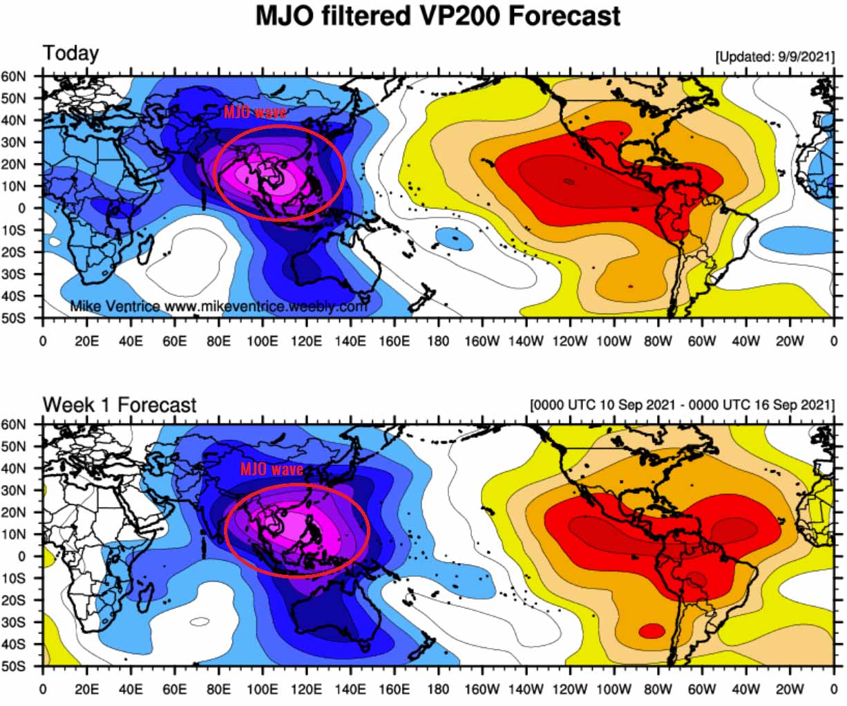
We can see how strong and deep the MJO wave is over the western Pacific. This is a perfect example of a *very* significant signal of the upward motion, supporting deep convection in the region where Super Typhoon Chanthu formed recently. While we can also see how reddish shade is over the Atlantic basin, this means (besides the ongoing hurricane Larry) that conditions are giving the Atlantic hurricane season a short break now.
The hot oceanic waters temperatures need to be very warm also deeper, not only at the surface as we could see on the chart above. To analyze this, we use another indicator to judge the potential development and especially the intensification rate of the tropical cyclone – that is known as the Ocean Heat Content (OHC). The OHC takes into account the depth of the sea and how warm are the water layers there, so how warm is the water deeper below the sea surface.
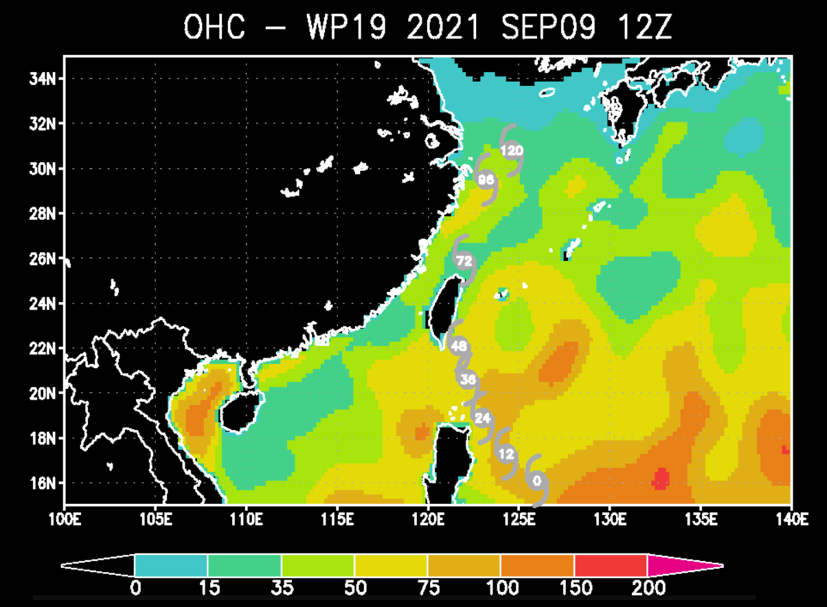
As we can see from the chart above, the deep oceanic waters are also quite warm where Chanthu is today and also farther north up to Taiwan where the typhoon is forecast to travel over the next 48 hours. These high values of OHC typically provide a very favorable environment with a thick layer of warm water. Tropical cyclones are fueled by these warm layers, as deep convective storms draw energy from hot water.
This means that the thicker the warm layers are, the more fuel/energy is there available to feed the (tropical) storms. And it could tell us, although the Chanthu might be past its peak today, it will remain a very powerful storm while moving farther north across these favorable oceanic conditions ahead.
SUPER TYPHOON CHANTHU WILL PASS NEAR PHILIPPINES, BUT MAKE LIFE-THREATENING LANDFALL IN EASTERN TAIWAN ON SUNDAY
As of this early Friday, the initial intensity of the Super Typhoon Chanthu is been set at 110-120 knots, based on a consensus of multiple agency Dvorak Final T- number estimates ranging from T5.6 to T7.0. Therefore reflecting an extremely intense tropical cyclone with a central pressure around 950 mbar. Just a day ago, Chanthu was remarkable on the satellite imagery with the pinhole eye.
The environmental conditions analysis indicates a favorable environment remains in place, as satellite imagery reveals a still well-developed radial outflow, low vertical wind shear, while Chanthu remains over very warm (near 30-31 °C) sea surface temperatures across the Philippine Sea.
After its completed EWRC, Chanthu is recovering quickly and a new, larger eye is becoming visible this Friday morning.

The wind field of Super Typhoon Chanthu is relatively small. Its hurricane-force winds are spread only across a radius of 40-50 miles, while tropical-storm-force winds are reaching out to 80 miles around the center of the typhoon. The gale-force winds (34 knots) are already affecting the eastern part of Luzon island, Philippines, about 160 miles away from the center as of this Friday morning.
We can also see the rate of rapid intensification on Wednesday evening and nighttime. Officially, the wind speed increase was from 65 knots to 125 knots between 06 and 18 UTC on Sept 7th, while it was from 45 knots to 125 knots between Sept 6th 18 UTC to Sept 7th 18 UTC. So 80 knots increase in just 24 hours period – that is extreme!

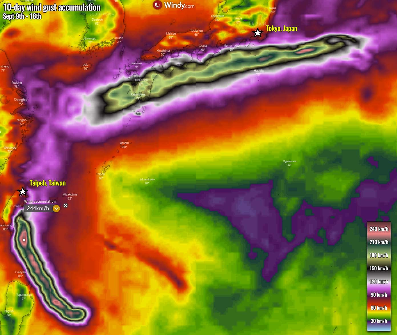
Super Typhoon Chanthu will continue as a violent system through Friday while passing very near the northeastern tip of Luzon island, Philippines before turning towards Taiwan on Saturday. The wind gusts swath map below hints at an intense winds Chanthu will maintain until the landfall in Taiwan on Sunday – probably gusting to more than 250 km/h, which is actually being underestimated as well. Destructive winds and major storm surge is likely along the eastern coasts on Sunday.
After the interaction with Taiwan’s complex terrain, Chanthu is forecast to weaken for a day or two but is likely to re-intensify rapidly again as it encounters the very warm East China Sea waters early next week. The general weather model consensus is actually quite well that Chanthu might become a powerful typhoon again as it enters southwestern Japan and accelerates east-northeast next week before transforming into an extratropical storm.
Another concern is the amount of rainfall that is forecast as typhoon Chanthu nears and impacts Taiwan from late Saturday into Sunday. The attached ECMWF model chart below is the rainfall total over the next 10 days, hinting at a huge amount of rainfall (300-400 mm) is possible along the typhoon’s track.
Although the exact track is still unknown for where it will make landfall in Taiwan, these amounts are high enough to cause dangerous flash floods and mudslides.

Once Super Typhoon Chanthu is past Taiwan farther north, also storms will be less intense. But if the weather forecast for its intensification verifies near Japan next week, major rainfall threats could develop, as well as dangerous winds. It all depends on how intense typhoon Chanthu would become after crossing the East China Sea. Conditions have to be closely monitored if they could threaten southwest and south Japan later next week.
***The images used in this article were provided by NOAA, and Windy.
If you like our content, don’t hesitate to bookmark the page to have all the new info ready at hand. Make sure to bookmark it, or click on ‘show more‘ if you are reading this article from the Google Discover feed.