The general weather pattern over Europe has completely flipped compared to what has been ongoing for weeks since mid-August. The historic heatwaves are over, and dynamic autumn season patterns have been established. The first excessive rainfall event hit Italy and the Alpine region this weekend, but a new system – an outbreak of cold air mass is already shaping up in the north.
This week, a significant temperature change will spread across much of Europe, thanks to an established broad corridor or meridional flow from the north towards the deep south and the Mediterranean.

From Thursday through Saturday, a strong contrast between the air masses will produce a frontal system across central Europe and the Mediterranean.
Temperatures will be the coldest in autumn 2024 with this cold outbreak.
It will trigger another excessive rainfall event and more risk for flooding across Italy, the Alpine region, and surrounding areas. In addition, the colder air mass will also bring extreme snowfall for the higher Alps, especially the northern parts.
Let’s dig into the details of the evolution of weather patterns throughout this week.
An upper wave emerges over western Europe, splits a deep cold core towards the Mediterranean
By this Monday, the first wave is finally diminishing, but the North Atlantic is already brewing signs of what’s next for the European continent late this week. A strong blocking High is established over the Atlantic, allowing cold air from the Arctic region to move towards the south. Thus, a deep and powerful upper wave forms in Western Europe before it dips south after midweek.
This pattern will establish a corridor of the cold air mass from the north towards the deep south over Europe, already reaching the Mediterranean by Thursday. The following 500 mbar heights chart represents the situation over Europe on Tuesday night.
We can see a blocking High on the North Atlantic and a deep upper trough emerging into western and northwestern Europe, with an open corridor towards the south.

Associated with the deep trough, a cold air intrusion establishes on Tuesday into the UK and Ireland, gradually but quite fast moving along the surface cold front across the rest of Western Europe. By Wednesday night, the cold already reaches South France and the Alps. Temperatures will be 6 to 10 °C colder than the average already.
The 850mb anomaly chart for Wednesday night also indicates how the cold blast is trapped between the two blocking Highs; one strong High is over the North Atlantic and Azores, while the other is over far Eastern Europe and Russia. The latter also results in a very warm air mass.

On Thursday, the deep upper trough gradually splits its southern lobe towards the south, transforming it into a large cold core low. Emerging across central Europe and the northern Mediterranean by Friday.
We can also see how the Atlantic blocking ridge cuts the corridor between the Arctic and continental Europe, inducing the cold core to become trapped and slow down its progress over the Mediterranean.

As typically happens with such a strong low and cold intrusion this far south, a deep surface low and a well-defined frontal system develop over the northern Mediterranean. This usually brings an intense front, with heavy and excessive rainfall, thunderstorms fueling from the warm seas, and fresh snow for the Alps.
This time will be no difference, a deep cold core will allow a sigificantly colder air mass to continue spreading far south on Friday, engulfing part of Iberia, western and central Mediterranean and Italy. The cold pool stalls and spreads east over the Balkan peninsula by the weekend.

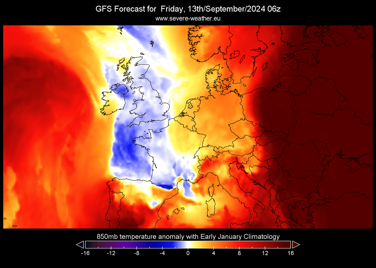
The air mass will be significantly colder than recently experienced, pushing temperatures around 10 °C below average for mid-September. The most anomalous air mass will be across France, the Alpine region, Italy, the Balkans, Austria, and Hungary.
Interestingly, let’s compare the upcoming cold outbreak with some climatological data. In the following chart, we can notice that the 850 mbar temperature anomaly (approximately 1250m above sea level) will be even colder than the climatological mean for the early January period.

This shows how unusually intense the intrusion of the cold air mass will be this week.
Next Saturday, the 2 m temperature anomaly indicates the air mass will be from 8 to 12 °C colder than usual across these countries. This should push morning temperatures into single digits in many countries underneath the cold pool.

It will, however, remain much warmer over far eastern Europe and western Russia.
Another round of intense and excessive rainfall for central Europe and the Mediterranean, deep snow for the Alps
A weather pattern shaping up late this week is a textbook recipe for an extended period of excessive rainfall and high risk for flooding across the Alpine region and the northern Mediterranean. And with the first round of excessive rainfall ending this Monday, the soil is soaked, and the Mediterranean Seas remain warm. Therefore, this enhances the potential for the upcoming intense rainfall event to support additional flooding.
The new frontal system will likely bring even more rainfall to northern Italy, Austria, Slovenia, and Croatia. History tells us these consecutive rainfall events are of great concern and should be closely monitored for potential flooding.

The chart above indicates the total rainfall over the next 10 days. A lot of rainfall is forecast along the Dynaric mountain range to northeast Italy, western Slovenia, and further north across Austria and south Germany. Rainfall sums could reach another 200+ mm within 72 hours of the event.
Note that this chart above is a global ECMWF weather model, so local anomalies (usually in a positive way) are likely to occur. Thus, even more rainfall could result in the end, and such amounts undoubtedly have considerable potential for additional floods over the already-soaked ground.
Another area of concern is the potential for excessive rainfall on the northern side of the Alps, associated with the secondary low that wobbles under the large upper core. The model guidance suggests that it could be traveling from the northern Balkans back towards Czechia and Eastern Germany over the weekend, thus introducing heavy rainfall in the region.

There is a high chance that a broad area of excessive rainfall will increase flooding potential from Southeast Germany and Northern Austria to western Czechia and southwestern Poland. These areas could receive 150-250 mm of rainfall by Sunday.
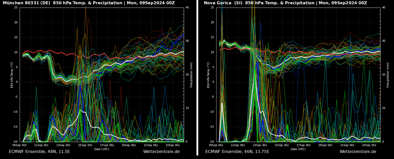
The Metegram charts below show both frontal systems with excessive rainfall. It compares two locations, Munich (southeast Germany) and Nova Gorica (western Slovenia), over the next 14 days. The first chart is for the northern side of the Alps, and the other is for the southern side.

The Munich Meteogram indicates an extended rainy period, with a sharp temperature drop on Thursday and a cold front blasting through. Rainfall lasts until Sunday. The Nova Gorica chart indicates the rainfall event will again be more intense and last longer than the last one. The spread of cold air mass is less sharp but noticeable.
One can also notice that the cold pool will remain across central Europe for several days.
In addition, this first significant cold wave of the autumn season of 2024 will also lead to the very first intense snowfall across the Alps. The weather models agree that extreme amounts of snow accumulation in the higher levels above 2000 m ASL will develop.

The accumulated new snow from Thursday through Monday next week is showing very high snow amounts along the northern Alpine flank. Locally, 100-150 cm of fresh snow could accumulate in some areas, even around 200 cm. This is particularly extreme for the first event of the cold season.
Stay alert for worsening weather conditions again in the coming days and late this week. Significant rainfall and flooding events, including severe weather and heavy snowfall in the Alps, are expected to occur.
Wxcharts and Pivotalweather provided images for this article.
See also: