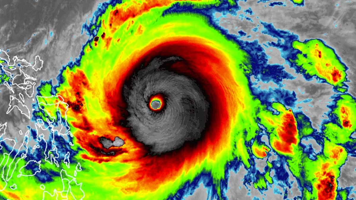
Who would have expected the very first Western Pacific typhoon of 2021 to take so explosive intensification rate that has brought it to a record Category 5 tropical cyclone? The peak intensify has reached an outstanding 190 mph with the central pressure bottomed at 888 mbar. Only the most violent systems push the eye pressure so low. Super Typhoon Surigae has also become the most intense tropical cyclone for the month of April, surpassing the typhoon Maysak from 2015. Surigae track will thankfully miss the Philippines.
According to the official analysis by the JTWC, Super Typhoon Surigae has peaked as a Category 5 tropical cyclone, packing a remarkable intensity of 190 mph sustained winds (165 knots). Its central pressure has pushed to 888 mbar, which is incredibly low for any tropical system worldwide.
Surigae has explosively intensified from a 90 mph Category 1 typhoon to a monster 190 mph Category 5 storm within a period of only 36 hours from Friday through Saturday! This is even more than double the rate for rapid intensification of a tropical cyclone. The peak intensity has been set just shortly before the Eyewall Replacement Cycle (EWRC) started.
These data are based on satellite observation, as aircraft do not fly into West Pacific typhoons the way NOAA Hurricane Hunters do in the Atlantic, So we, unfortunately, will never know exactly how intense Super Typhoon Surigae actually is. We shouldn’t be surprised that the 190 mph intensity this Saturday might even be an underestimate.
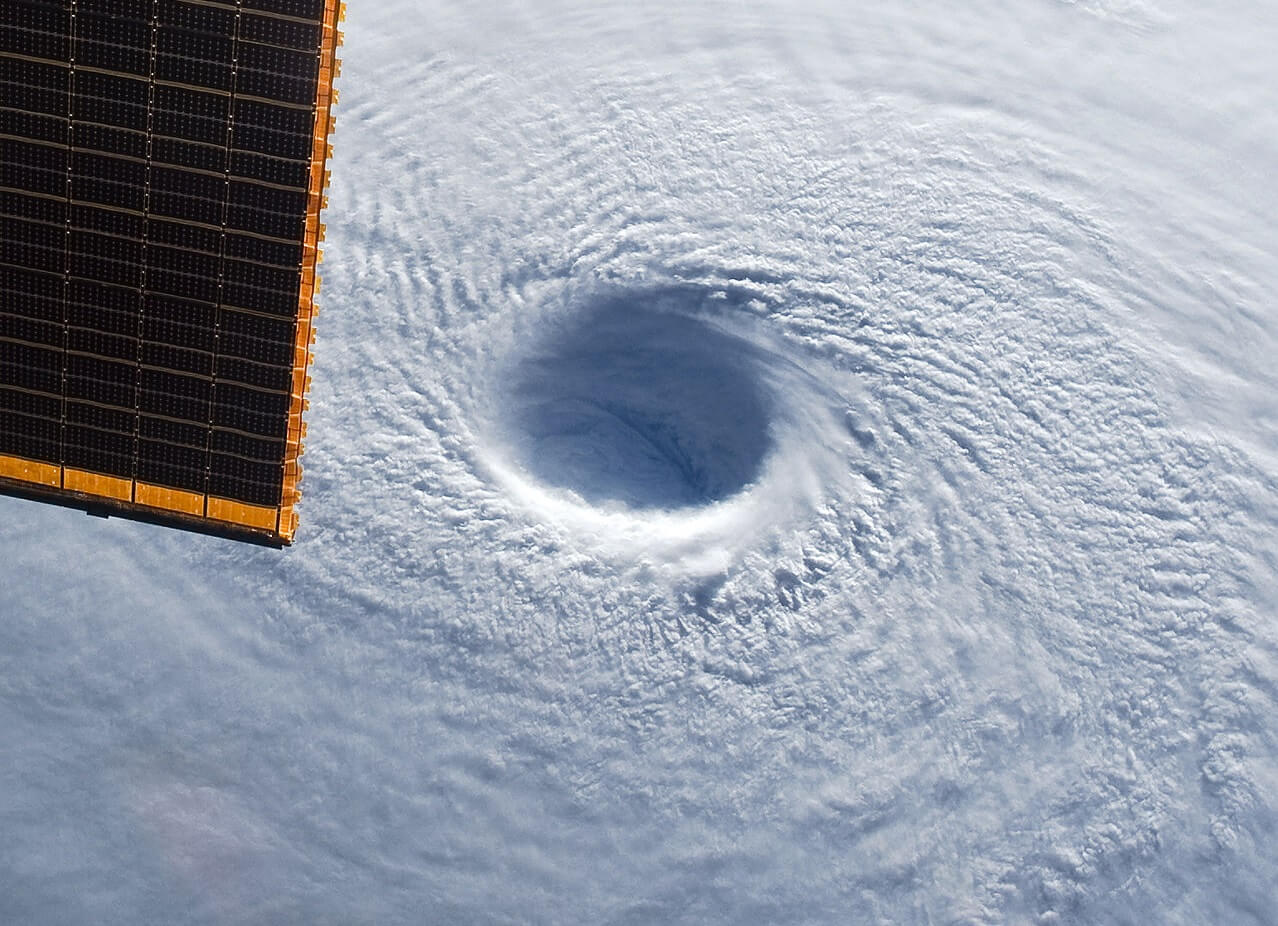
Super Typhoon Surigae has therefore become the most intense typhoon on record for the month of April. And also becomes the first Northern Hemisphere tropical cyclone to reach sub-900 millibar intensity prior to May 1st. Breaking the previous record set by Typhoon Maysak in 2015. Attached below is the exceptional view of the eyewall of Maysak, known as the stadium effect.
Super Typhoon Surigae (known as Bising in the Philippines) literally exploded in intensity from a Category 1 storm on Friday to a beastly Category 5 monster on Saturday, with maximum sustained winds estimated at 190 mph with higher gusts.
Like we are almost used to see over the recent years, Surigae is just the latest tropical cyclone out of many that underwent a process known as rapid intensification, a process that leads to a very significant increase in winds and an extremely deep central pressure of tropical (or also non-tropical) systems. Warming seas are likely the cause for this, according to scientific researches.
Based on the latest model guidance, the northern portions of the Philippines are likely to spare the worst impact of this monster Super Typhoon. The model tracks hint at the Surigae to recurve out to the sea further north, so chances of it to directly hit the northern parts of Luzon are much lower now. Still, heavy rains with flooding potential and severe winds are possible.
Surigae is the first Category 5 tropical cyclone (of any category that includes hurricanes, typhoons, and cyclones) to occur in 2021. A typical year brings about 18 tropical systems that reach a Category 4 or 5 around the world.
The driver behind these explosive tropical cyclone formations is very often the very warm sea waters and the wave known as a Madden-Jullian Oscillation (MJO). The combination of both has also lead to a formation of a strong tropical cyclone Seroja that struck Western Australia, just a week before typhoon Surigae formed. Seroja formed after a spectacular Fujiwhara effect of a merging system with a tropical cyclone Odette.
Typically over a normal year, about 8-9 tropical cyclone formations threaten the land of the Philippines. This is the highest number of tropical systems that strike any country around the world.
Typhoon Surigae remains an extremely dangerous system although its center is now forecast to miss the Philippines, it will still travel just a few hundred miles/kilometers to the east of the northern parts of the country. It may still affect the north-northeast Philippines (Luzon) with a huge amount of rainfall and severe winds and dangerous storm surge.
SURIGAE AS A RESULT OF VERY WARM PACIFIC OCEAN AND A MAJOR MJO WAVE
The sea surface temperatures of the western Pacific are very warm this spring, even extremely warm with hot conditions further west towards the Indian Sea. Temperatures are reaching up to about 30 °C (86 °F). Hot seas with temperatures even above 31 °C (87 °F) are being observed over the Gulf of Thailand and the Andaman Sea.
Such oceanic conditions are strongly supportive of an explosive intensification for any tropical cyclone. This is also the main reason why Surigae has literally exploded into a powerful Category 5 typhoon this weekend and reached a remarkable maximum sustained winds speed of 190 mph (165 knots).

The waters of the Philippine Sea remain warmer than the long-term average, about 1 °C above normal. Strongly anomalous sea temperature often leads to the explosive development of deep storms, that develop very well-organized tropical cyclones. And often undergoing a very rapid to even explosive intensification as we have seen with Surigae.
As it can be seen from the attached sea temperature anomaly chart, most of the western Pacific is well above average. Also further west across the Indian Sea. The highest temperature anomalies are observed around Japan and across the Northwest Pacific.

Notice also how cold waters are present over the Bering Sea and the Sea of Okhotsk, which is partially frozen. There, frigid Arctic conditions are still in place, as winter hasn’t left the areas that far north through early/mid-April this year.
Another factor that has recently significantly increased the potential for tropical cyclone developments over the western Pacific is the so-called MJO wave. The wave has well coincided with the above normal sea temperatures over the western Pacific. The Madden-Julian Oscillation (MJO) is the largest and most dominant source of short-term tropical variability. An eastward-moving wave of thunderstorms circles the entire planet on the equator in about 30 to 60 days.
The MJO has two parts, one side is the enhanced rainfall (wet phase) and the other side is the suppressed rainfall (dry phase). This means that there are increased storms with a lot of rainfall on one side and reduced storms potential and drier weather on the other side. The wet phase leads to diverging (ascending) air parcels while the dry phase brings converging (descending) air parcels. This horizontal movement of the air is referred to as the Velocity Potential (VP) in the tropics.

With the model data, we can easily track the entire MJO wave movement by looking at the larger scale air parcels movement. And can easily see the areas where the air is rising and where it is subsiding.
The graphics below, provided by Michael J. Ventrice, Ph.D. represent an MJO wave with filtered VP200* anomalies (see details below) for the current state, for the week 1 forecast, and for the week 2 forecast.

Cold colors are representative of a more favorable state over the Pacific Ocean for tropical cyclogenesis while warm colors represent a less favorable state for tropical cyclogenesis (e.g. over Africa and South Atlantic).
*VP200 – means a Velocity Potential (VP). It is an indicator of the large-scale divergent flow, so at upper levels in the tropics. The negative VP anomalies (shaded blue in the diagram) are closely tied to the divergent outflow from enhanced convective regions.
Notice how strong and deep the MJO wave is over the western Pacific. This is normally a *very* significant signal of the upward motion, supporting vigorous convection in the region where Super Typhoon Surigae formed.
But there is even more. Another important factor for the development and especially the intensification rate of the tropical cyclone is the Ocean Heat Content (OHC). The OHC takes into account the depth of the sea, and how warm the water layers are deeper below the sea surface.
The attached chart for the region of the western Pacific has recently hinted at a large pool of very high available oceanic heat energy. With a very warm water layer running down quite deep over the Philippine Sea. Taking a closer look, one can see how Surigae has been moving right across these very favorable conditions this weekend. No wonder why it has been so explosively organizing.
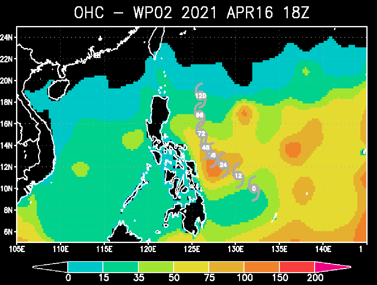
The deep waters are also quite warm which typically provides a very favorable environment of a thick layer of warm water. Tropical systems are fueled by these warm layers, as deep convective storms draw energy from hot water. So simplified this means that the thicker the warm layers are, the more fuel/energy is there available to feed the (tropical) storms.
SUPER TYPHOON SURIGAE WILL LIKELY SAVE PHILIPPINES FROM THE WORST
The initial intensity of the Super Typhoon Surigae has been set at 190 mph (165 knots), based on a consensus of multiple agency Dvorak Final T- number estimates ranging from T7.5 to T8.0 (165 – 170 knots). Therefore reflecting an extremely intense tropical cyclone.
The environmental analysis indicates a favorable environment with robust radial outflow, low 10-15 knots vertical wind shear, and very warm (near 30 °C) sea surface temperatures across the Philippine Sea.
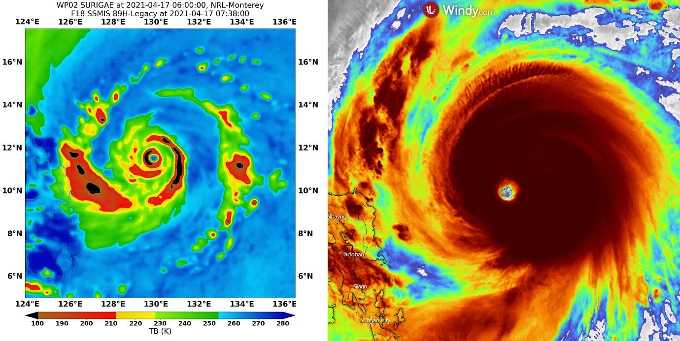
Based on the advanced Dvorak estimation, the initial intensity is set at 165-170 knots, a violent and a powerful Category 5 tropical cyclone. The environmental analysis reveals impressive upper-level outflow ventilation, with well-defined gravity waves as well (see the infrared image at the beginning of the article). Attached above are the microwave and infrared satellite images during the peak intensity on Saturday.
The wind field of Surigae is very big. Its hurricane-force winds are spread across the radius of 50-70 miles, while tropical-storm-force winds are reaching out to 105 miles around the dead center of the typhoon. Notice how the gale-force winds (34 knots) are brushing the eastern Philippines, about 200 miles away from the center.
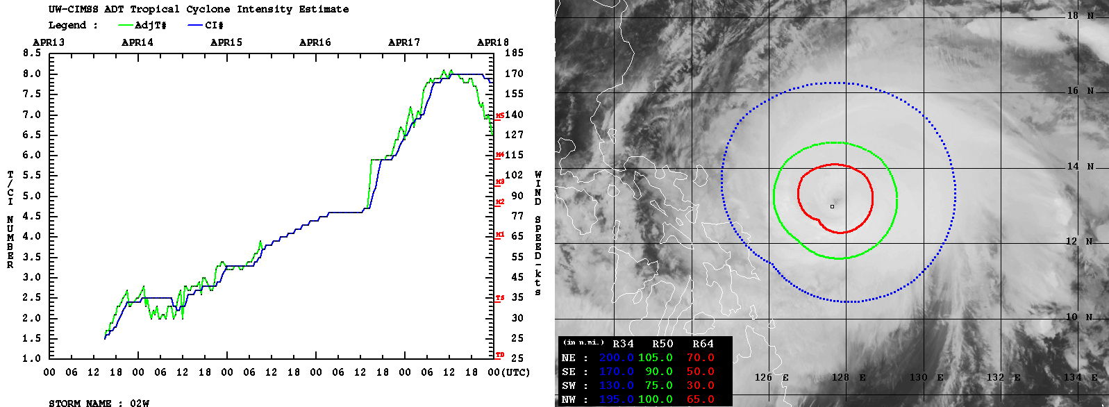
What is probably the most impressive to see is the intensification rate chart on the left, it indicates the increase in winds/intensity from its birth 4.5 days ago. The intensification was gradual and quite rapid until late Friday (local time) until it reached 80 knots and a Category 2 strength. Then becoming explosive for about 24 hours, reaching 165-170 knots and a monster Category 5 strength.
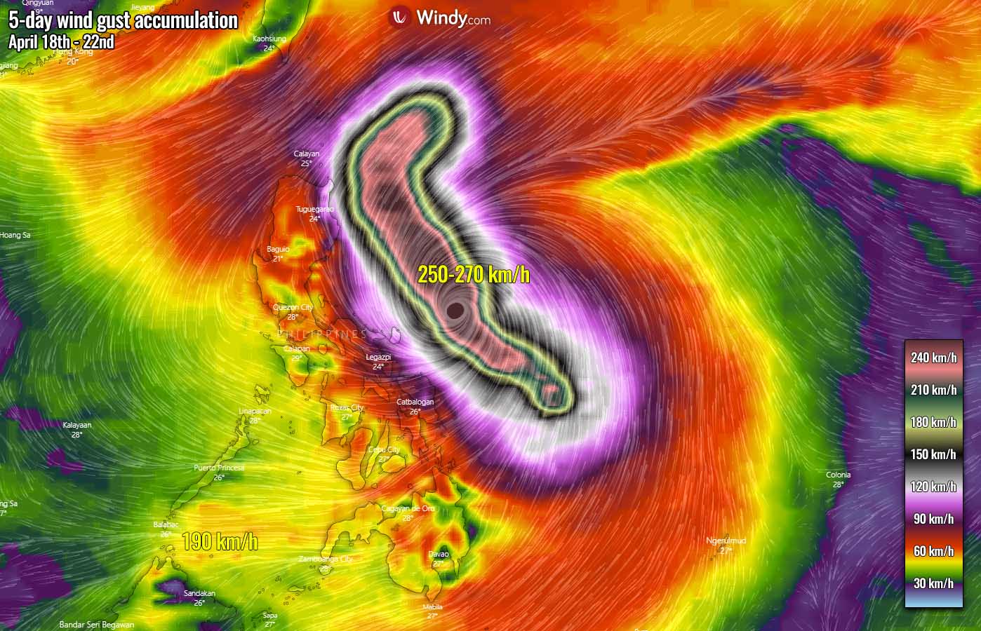
Super Typhoon Surigae will continue as a very violent system through Sunday, maintaining its Category 5 strength or maybe a high-end Category 4 intensity for another 12-36 hours. Surigae has become a very violent tropical cyclone and it will continue gradually moving northwest over the next couple of days. The wind gusts swath map below hints at an intense winds Surigae has developed – more than 250 km/h even forecast by the weather model.
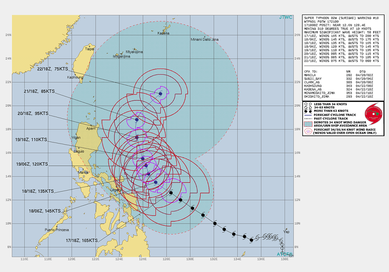
The latest model guidance charts hint that the recurve more northerly than westerly will likely spare the northeastern portions of Luzon from the worst impact. Some weather forecast models are, however, still forecasting the storm could also get extremely close to Luzon coast by Tuesday, but the majority of the models keep the future track farther offshore with much less dangerous impact to the Philippines land.
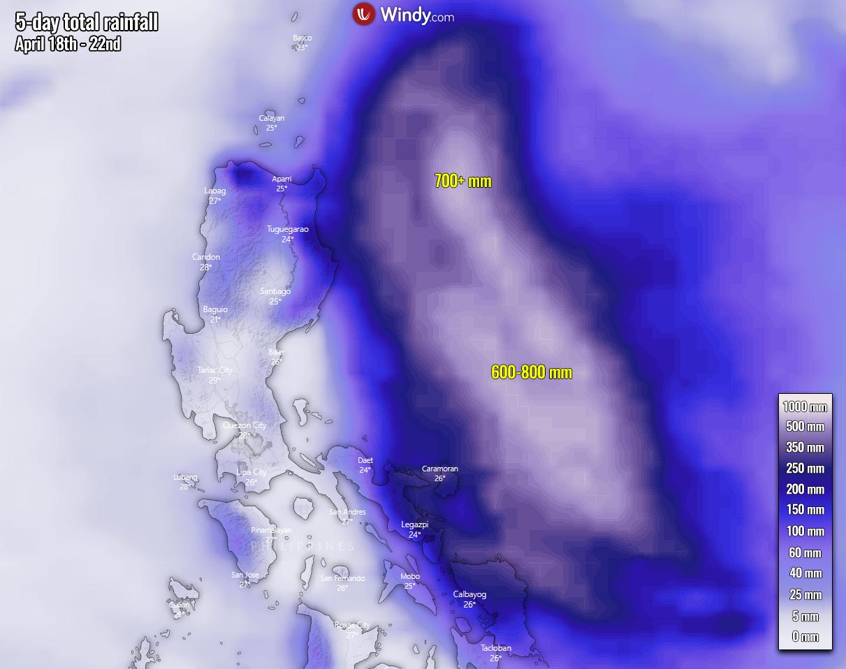
Attached below is the rainfall total map over the next 5 days, based on the ECMWF model. A huge amount of rainfall (600-800 mm) is underway around the core of the typhoon, but the recent model data suggest the worst part could miss the northern Luzon island, as it stays off to the east. If eventually, a more westerly shift occurs, life-threatening flooding potential could develop. We can see 500-800 mm of rain will be possible.
Once Super Typhoon Surigae begins losing its strength and moves away from the Philippines, much less favorable oceanic conditions for fueling the tropical cyclone will exist. However, conditions should be very closely monitored if Surigae could threaten Japan island Iwo To or even Japan mainland later next week. Stay tuned for further updates!
***The images used in this article were provided by Wxcharts, NOAA, and Windy.
Don’t forget to bookmark our page to have all the new info ready at hand. Make sure to bookmark our page, or click on ‘show more‘ if you are reading this article from the Google Discover feed.