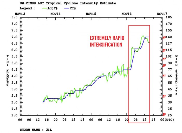
Iota has been upgraded to a Category 5 hurricane on Monday – the strongest Atlantic storm of the 2020 hurricane season. An extremely rapid intensification has brought the winds to 160 mph and the central pressure to around 918 mbar. Iota is heading west towards Nicaragua and Honduras where catastrophic flooding and life-threatening mudslides are expected tonight.
Hurricane Iota continues its rapid intensification and is maintaining the extremely dangerous Category 5 strength. It is expected to remain a catastrophic Category 5 hurricane when it approaches the coast of Nicaragua tonight.
*HURRICANE WARNING is in effect along portions of northeastern Nicaragua and eastern Honduras where potentially catastrophic winds and a life-threatening storm surge are expected*
This is an extremely dangerous situation unfolding for northeastern Nicaragua with a major storm surge of 15-20 ft forecast along with destructive winds and potentially 30 inches of rainfall.
Through Thursday, heavy rainfall from Iota will likely lead to life-threatening flash flooding and river flooding across portions of Central America. Flooding and mudslides in Honduras and Nicaragua could be exacerbated by Hurricane Eta’s recent effects there, resulting in significant to potentially catastrophic impacts.
Hurricane conditions and storm surge impacts are likely still occurring in Providencia. Tropical storm conditions are expected and hurricane conditions are possible in San Andres.
Central American countries Nicaragua, Honduras, and Guatemala are suffering a significant humanitarian crisis after the destructive impact of a high-end Category 4 hurricane Eta last week. Eta has brought a high death toll due to the remarkable amount of rainfall, lead to deadly flooding and mudslides.
Through Friday morning, heavy rainfall from Iota are expected to bring additional life-threatening flash floods and river flooding across portions of Central America. Flooding and mudslides in Honduras are very likely again.
IOTA IS THE FIRST CATEGORY 5 LATE-SEASON HURRICANE
Iota is the latest Atlantic calendar year Category 5 hurricane on record. The previous record was November 8th by the Cuba Hurricane (1932).
It is also the 2nd major hurricane to form this November (major Hurricane Eta was the first one). This sets another remarkable record for the 2020 Atlantic hurricane season – there are no seasons on record that have had two major hurricane formations in the month of November!
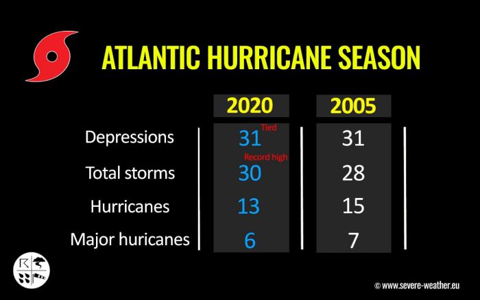
Iota is the 13th hurricane of the already record-breaking Atlantic 2020 hurricane season and has entered a rapid strengthening phase on Sunday, Nov 15th. It has explosively developed into a Category 5 since then.
It is also the 6th major hurricane of the season and the first Greek alphabet Atlantic named storm to reach Category 5 intensity on record.
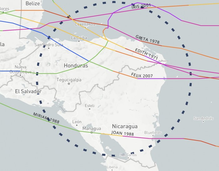
Prior to 2020, there have only been five (5) Category 4 (or higher) hurricane landfalls in Honduras and Nicaragua. Those were Felix (2007), Joan (1988), Greta (1978), Edith (1971), and an Unnamed Hurricane (1941).
While a high-end Category 4 landfall of hurricane Eta was the 6th, Iota will be the 7th Category 4+ landfall in the region in the recorded history.
As Iota is forecast to made landfall as a Category 5 intensity in Nicaragua, it will be the 3rd Category 5 landfall on record. The other two were Edith (1971) and Felix (2007).
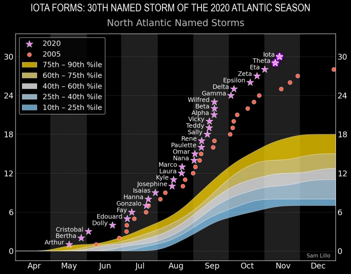
The chart above is showing a comparison of 2020 versus 2005 seasons, compared to the average season percentile. The Atlantic hurricane season 2020 is remarkable! Graphics are provided by Sam Lillo.
IOTA FUELING FROM THE EXTREMELY WARM CARIBBEAN SEA
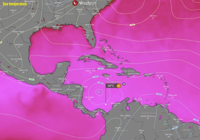
The sea surface temperatures remain very warm in the Western Atlantic, and extremely warm over the Caribbean region with around 30 °C (86 °F) across the western portions of the Caribbean Sea.
This is a very worrying signal as sea waters remain much higher than the long-term average. This is why Iota has been so explosively developing, and it also means that it will bring a very high amount of moisture with violent thunderstorms towards Central America, leading to destructive flooding.
Graphics below are provided by Windy.com.
The majority of the North Atlantic, tropical Atlantic, and the Caribbean are still well-above average, about 1-2 °C warmer, even more across the Northwest Atlantic.
Waters remain warm, much above the long-term average across the whole Gulf of Mexico, around Florida, the Bahamas, and along the East Coast of the United States.
And to top this, there is still a pronounced MJO wave underway over the tropical Atlantic, ongoing since the end of September.
The Madden-Julian Oscillation (MJO) is the largest and most dominant source of short-term tropical variability, it is an eastward-moving wave of thunderstorms, clouds, rain, winds, and pressure. It circles the entire planet on the equator in about 30 to 60 days.
As we can see from the graphics below, it is a very obvious feature this week (first chart and marked with a red circle), with blue color over the Atlantic basin. On the week 1 forecast (second chart) the MJO wave will begin weakening but still not completely vanished.
So this means that it will continue lowering the pressure and providing a strong boost to thunderstorm activity in the tropical Atlantic towards through mid to end of November.
The above graphics, provided by Michael J. Ventrice, Ph.D. represent an MJO wave with filtered VP200* anomalies for the current state and for the week 1 forecast.
Cold colors are representative of a more favorable state over the Atlantic for tropical cyclogenesis while warm colors represent a less favorable state for tropical cyclogenesis.
*VP200 – means a Velocity Potential (VP). It is an indicator of the large scale divergent flow, so at upper levels in the tropics. The negative VP anomalies (shaded blue in the diagram) are closely tied to the divergent outflow from enhanced convective regions.
EXPLOSIVE/RAPID INTENSIFICATION OF IOTA
Iota is a very impressive hurricane, with a distinct, warm eye on satellite images and a rather electrified eyewall from the GOES lightning detector. A little more strengthening is possible today with fairly light shear and warm waters before Iota makes landfall tonight.
Iota is an exceptional hurricane in both visible and infrared satellite imagery and the hurricane has continued to improve on Monday afternoon. The hurricane has a well-defined intense eyewall, surrounded by large and symmetric Central Dense Overcast (COD). Cloud tops within the eyewall often have a temperature close to -85 degrees Celsius.
The sustained winds have increased from 75 knots to 140 knots over the past 24 hours (65 knots increase) while Iota continues further rapid intensification. Also, Hurricane Iota has intensified 85 knots (100 mph) in 36 hours.
Only eight (8) storms have done this in 169 years of hurricane records prior to 2020. Those were Labor Day (1935), Camille (1969), Andrew (1992), Rita (2005), Wilma (2005), Felix (2007), Matthew (2016), and Maria (2017).
In the Atlantic 2020 hurricane season, three (3) additional storms have done such a pressure drop in the last two months – Delta, Eta, Iota!
This is just another example how exceptional hurricane season this year is.
The upper-level outflow ventilation is really outstanding. It is widely open in all directions, definitely in line with the system’s explosive strengthening over the past 24 hours.
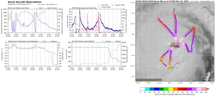
An Air Force Reserve Hurricane Hunter aircraft found the maximum 700-mbar flight-level winds of about 147 knots, with SFMR values of 140-145 knots (160-165 mph), and a central pressure of about 917 mbar.
A blend of all these data leads to an initial wind speed of 140 kt, making Iota a Category 5 hurricane, the latest Category 5 on record for the Atlantic basin.
Furthermore, NOAA Hurricane Hunters have also reported that the pressure fell an amazing 10 mbar from 945 mbar down to 935 mbar in a little over an hour between the last two aircraft passes from 5-6 UTC on Monday morning.
The crew also encountered intense lightning and hail in the southwestern quadrant, where recent remote data indicate that frequent lightning is still occurring. This is *extremely* rare occurrence in the hurricanes.
The aircrew also reported that the eye was around 15 n mi wide.
Based on the Advanced Dvorak Technique (ADT) analysis estimation Iota’s tropical-storm-force 50-knot winds are spread across the 70-90 mile radii around the eye.
While hurricane Iota is expanding around 40-60 radii of hurricane-force 64-knot winds. The wind field is still expanding and strengthening, spreading into the far northeast Nicaragua.
Hurricane Iota has been steadily intensifying since Saturday afternoon but it took a higher gear on Sunday afternoon. The rapid intensification was very explosive as Iota arrived in much more favorable conditions with basically zero deep-layer shear.
Extremely warm seas lead to explosive storms that Iota began rapidly deepening its central pressure, more than 60 mbar pressure drop over the past 24 hours! A new record for the month of November.
Iota is now a Category 5 hurricane with around 140-145 knots (160-165 mph) of sustained winds and has become a very violent hurricane!
CATASTROPHIC LANDFALL IN NICARAGUA EXPECTED
Very favorable atmospheric and oceanic conditions consisting of zero vertical wind shear and warm waters are expected to continue its rapid strengthening until the landfall in Nicaragua tonight.
The NHC intensity forecast again calls for Iota to maintain a Category 5 hurricane intensity during landfall. There seem barely any signs of potential weakening, so Iota will remain violent near 160 mph intensity hurricane at the landfall, occurring in northeast Nicaragua on Monday night.
Iota is moving westward to west-northwestward at about 9 knots, its track remains almost unchanged from before, just slightly more south-southwesterly trajectory. A strong mid-level ridge that extends across the western Atlantic and Florida will steer Iota westward through landfall Monday night.
The relatively slow forward speed of Iota is a great concern as catastrophic flooding is likely to be expected with storms maintaining for a longer period over the affected areas. As after it makes landfall in Central America, torrential rains and flooding will be a major threat from Iota.
The potential landfall impact will again be near the city of Puerto Cabezas (a city with a population near 60.000) in northeastern Nicaragua. The city is in the highest threat to be devastated with Category 5 winds.
The impact will be violent and should cause additional significant damage that was left after hurricane Eta.
DESTRUCTIVE FLOODING AND MUDSLIDES EXPECTED
In addition to potentially catastrophic winds, Iota is expected to bring a life-threatening storm surge and extreme rainfall impacts to portions of Central America. This comes less than two weeks after another hurricane – a major Hurricane Eta significantly impacted the area.
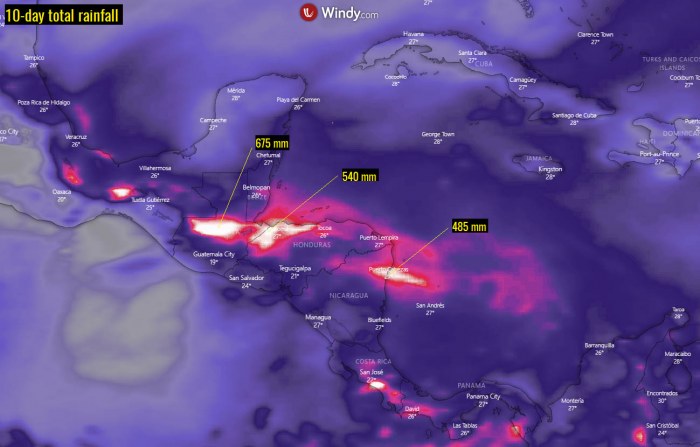
The amount of rainfall is the greatest concern. The total amount of rainfall forecast over this week is exceptional and will lead to catastrophic flash floods and mudslides.
And this will significantly worsen the ongoing flooding disaster in the Central American region.
Hurricane preparedness should be nearly completed in Nicaragua, Honduras, and Guatemala now as a major disaster is expected. The European model, ECMWF, is simulating an extremely concerning amount of rainfall.
There is a high potential for another 400-700 mm (15-25 inches) of rain possible in many areas. While the land is already completely soaked after hurricane Eta’s destructive and deadly impact last week.
Again there is a HIGH RISK for life-threatening, deadly flooding, and mudslides. Just a week after the *same* region was impacted by deadly flooding and mudslides.
Extreme amounts of rain are expected near the Iota’s landfall point in northeast Nicaragua. There also further west across northwestern Honduras, and central Guatemala. All these areas could see 500+ mm until the next weekend.
After landfall, rapid weakening should occur as Iota moves over the mountainous terrain of Central America and Iota should dissipate in a couple of days.
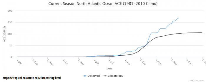
Iota will push the remarkable 2020 Atlantic hurricane season very high. As the Greek alphabet named storms (Alpha thru Iota) has now generated 69 ACE. This is enough Accumulated Cyclone Energy (ACE) to meet the NOAA average Atlantic hurricane season definition as of Nov 15th.
Remember that the average hurricane season generates ACE between 66 and 111! Remarkable!
What is the Accumulated Cyclone Energy (ACE index)?
The Accumulated Cyclone Energy is the energy output of a hurricane season, calculated as an index (ACE index). It is a metric used to express the energy used by a tropical cyclone during its lifetime. The index calculation takes the cyclone’s maximum sustained winds every six hours and multiplies it by itself to generate the values. The total sum of these values is calculated to get the total for a storm.
The current Atlantic basin ACE is, as of November 15th, already at 170. That is an impressive 68 percent higher than during a normal season to this date (101.3).
The highest ACE so far this season was generated by Teddy (27.8), Eta (18.1), Paulette (15.9), Delta (15.7), Epsilon (13.1), and Laura (12.8). The current system – hurricane Iota – added another 6.8 to the ACE index total for the Atlantic 2020 hurricane season so far (as of Nov 16th).
But indeed Iota’s ACE value is not final yet as it will be adding much more with its major hurricane strength until the landfall in Central America.
With the Accumulated Cyclone Energy (ACE) index above the ‘extremely active’ threshold of 152.5, this means that the 2020 Atlantic hurricane season is now officially an extremely active season.
However, there is still a long run to reach the strongest Atlantic hurricane season like 1933 (ACE of 258.6), 2005 (250.1), or 1893 (231.2).
30+ NAMED STORMS IN 2020, MORE STORMS LIKELY
Iota is the 30th named storm of the 2020 Atlantic hurricane season. It is also the 9th named storm from the Greek Alphabet list and also the 31st tropical depression forming in 2020 (tied 31 depressions forming in 2005).
Theta, therefore, is the ninth (9th) named storm from the Greek alphabet list. So we are now well above the previous record of 6 named storms from this list, set in 2005.
The 2020 Atlantic hurricane season remains on course for an even more exceptionally record-setting year to date, Nov 15th.
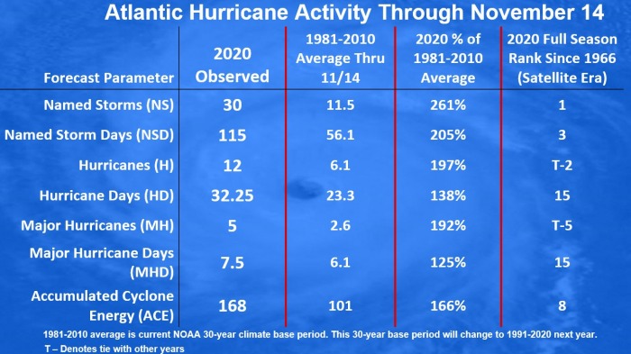
There were 30 named storms, which is about 261 % of the long-term average (11.5) for this time period. So far, there were more than double the number of hurricanes (13) and five (5) major hurricanes (Laura, Teddy, Delta, Zeta, and Eta). Iota is soon the 6th major hurricane of the season.
28 storms out of those 30 total, had the earliest formation date on record.
As of Nov 15th, there have been 116 named storm days so far, which is around 206 % of the average number (56.2). As we can see from the statistical graphics above (see the column 2nd from the right), all the forecast parameters are greatly much above average.
Including hurricane days (33), major hurricanes (5), and major hurricane days (7.5). Provided graphics are by dr. Philip Klotzbach.
The hurricane season 2020 is now the most active on record, breaking the previous record hurricane season 2005. The 2005 season had three (3) named storm formations in November, while 2020 is currently also counting three storm formations (Eta formed on Nov 1st, Theta on Nov 8th and Iota formed on Nov 13th).
With a still high potential for a few more tropical depressions or storms forming through November, we might be reaching halfway through the Greek Alphabet names. The potential remains high that additional storms could form in the next two weeks.
KAPPA COULD FORM NEXT WEEK?
Global models are definitely trending this way and also the National Hurricane Center (NHC) hints another tropical wave could be another tropical depression or a tropical storm late this week. The next named storm would get a name Kappa.
An area of low pressure could form in a few days over the central or southwestern Caribbean Sea. Development, if any, of this system should be slow to occur late this week while it moves slowly westward across the southwestern Caribbean Sea.
The NHC is giving this wave a 40 percent (%) chance to become a tropical storm over the next 5 days.
There seems to be a fairly high chance that the well-above-average western Atlantic and Caribbean region sea temperatures would be favorable for tropical storm formation even in December this year. And season might be aiming towards Nu or Xi storm names at the end.
Stay tuned!
Don’t miss a chance for a nice gift for your friends, family or someone special… Weather calendar could be the perfect gift for them – see below:

