Severe weather outlook – forecast across Europe. This forecast features areas of organized severe weather with risk levels and severe weather threats across the European continent.
SEVERE WEATHER OUTLOOK – DAY 1
Valid: 01/07/2021 06 UTC – 02/07/2021 06 UTC
Issued by: Severe Weather Europe
Forecaster: Marko Korošec
SUMMARY
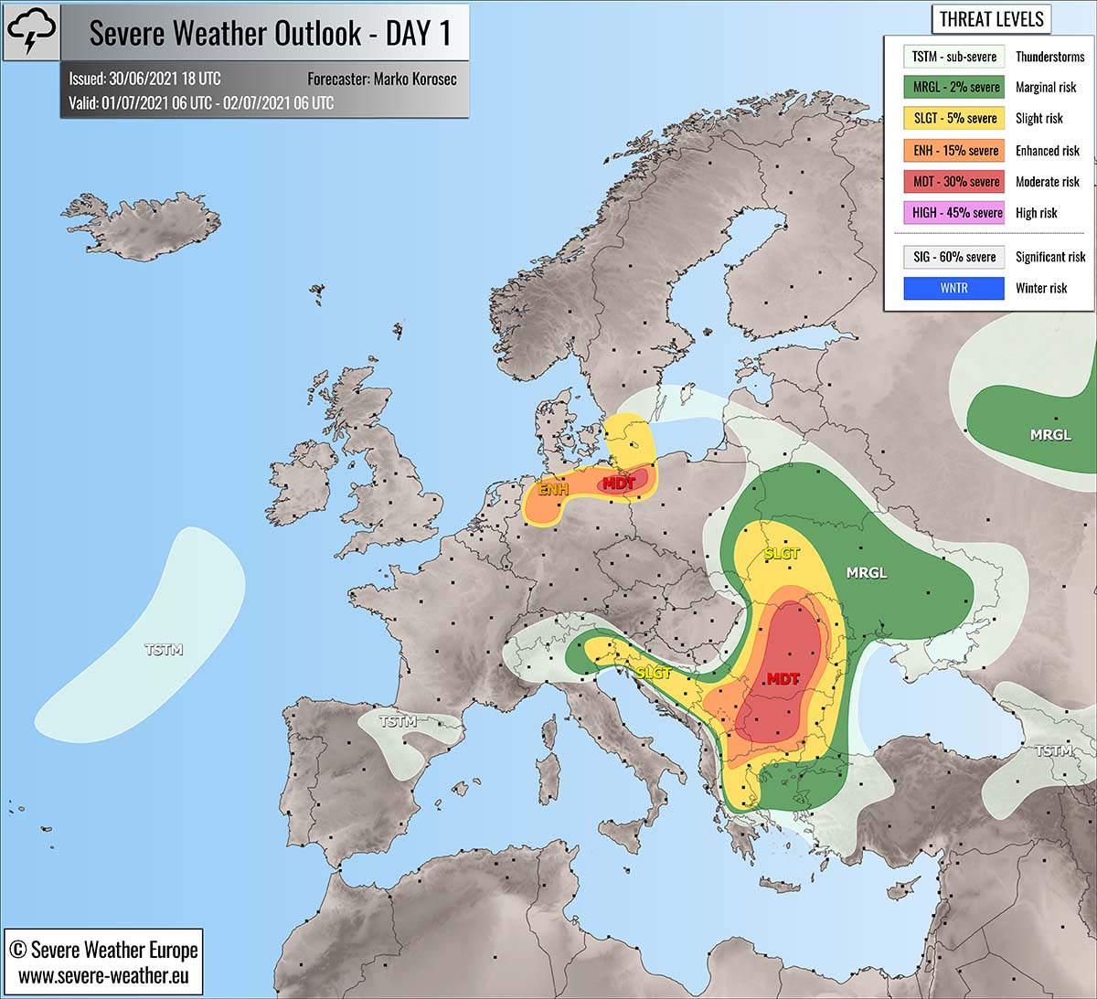
A very active day of severe weather is expected across parts of the Balkan peninsula. Thanks to the large-scale upper-level forcing associated with the approaching upper low across the northern Balkans. Strongly unstable air mass couplets with moderately strong shear and supports organized severe thunderstorms.
The most robust severe storms are likely across Bulgaria and Romania where the best conditions for supercells with very large hail and severe winds are present in the afternoon. Storms will gradually merge into a large cluster towards the evening hours.
For this reason, an MDT (moderate) risk has been issued to highlight the areas where the most intense and dangerous severe thunderstorms are likely to develop on Thursday.
Another area of interest is the MDT risk across northeast Germany into northwest Poland where a localized swath of very heavy and excessive rainfall is underway and will continue through Thursday. Severe flooding could occur due to high rainfall amounts.
Above: Video animation of the convective storm’s development across Europe from Thursday morning into the early Friday morning, July 1st to 2nd, 2021.
Weather forecast overview of the risk areas across Europe
SYNOPTIC OVERVIEW
The general weather pattern across Europe indicates a strong blocking High over northern Europe and northeast Atlantic, with a shallow but rather large upper trough moving east across central Europe and the Balkan peninsula. This will be the main focus for robust convective activity of the day.
At the surface, a surface low is gradually weakening over northwestern Poland, responsible for dangerous stationary rainfall events there. Further south, a diffuse frontal boundary moves eastern over the Balkan peninsula.
WEATHER FORECAST DISCUSSION
+++ Weather forecast for Bulgaria, Romania, Serbia, Greece, and North Macedonia +++
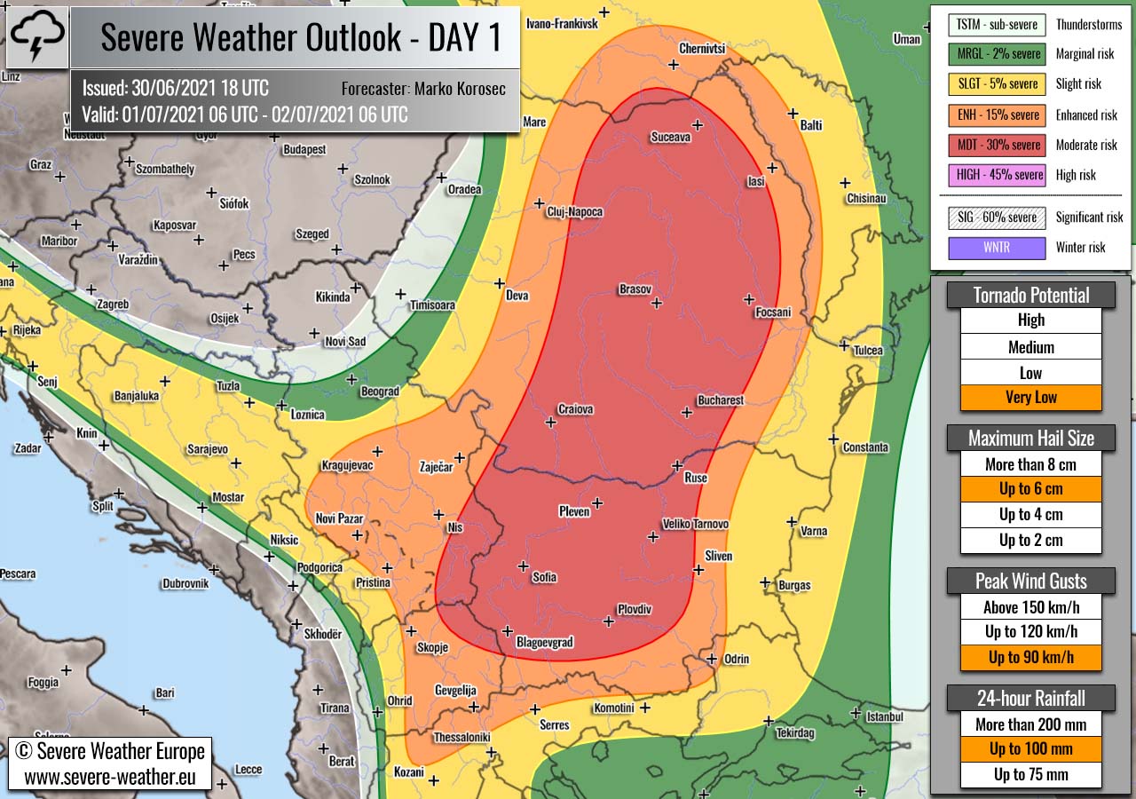
Highlighted severe weather threats:
- Tornado potential: Very low
- Maximum hail size: Up to 6 cm
- Peak wind gusts: Up to 90 km/h
- 24-hour rainfall: Up to 100 mm
MDT/ENH risks have been issued for Bulgaria, Romania into western Ukraine, southern Serbia, North Macedonia, and northern Greece with threat for scattered severe storms capable of producing large to very large hail, severe winds, and excessive rainfall.
Diurnal heating will contribute to high to extreme instability across parts of the Balkan peninsula, as a very moist air mass is present. MLCAPE could reach around 2000 J/kg in places. At the same time, the approaching upper trough from the west-northwest will also increase the wind field.
This will allow moderate shear of 30-40 knots to overspread the strongly unstable boundary layer and lead to the explosive development of severe storms, including intense supercell thunderstorms. Those will be capable of producing large to very large hail, possibly up to 6 cm in diameter locally. Severe winds and torrential rainfall threats will also exist.
SLGT risk has been issued for areas surrounding the MDT/ENH risks across the southern and eastern Balkan peninsula with less coverage of severe weather.
Storms will be gradually merging into a cluster or two into the evening hours while the activity spreads east towards the western Black Sea. The primary threat will remain very heavy rain and severe winds. Especially if an organized line of storms develops towards coastal eastern Romania.
For this reason the SLGT risk was also extended further east.
+++ Weather forecast for Germany and Poland +++

Highlighted severe weather threats:
- 24-hour rainfall: Up to 100 mm
MDT/ENH/SLGT risks have been issued for north-northeast Germany into northwest Poland with a threat for heavy and excessive rainfall.
Maintaining heavy rain will locally bring high amounts of additional rainfall over already soaked soil and ongoing torrential rain, resulting in dangerous flooding threats.
+++ Weather forecast for Italy, Slovenia, Croatia, and Bosnia +++
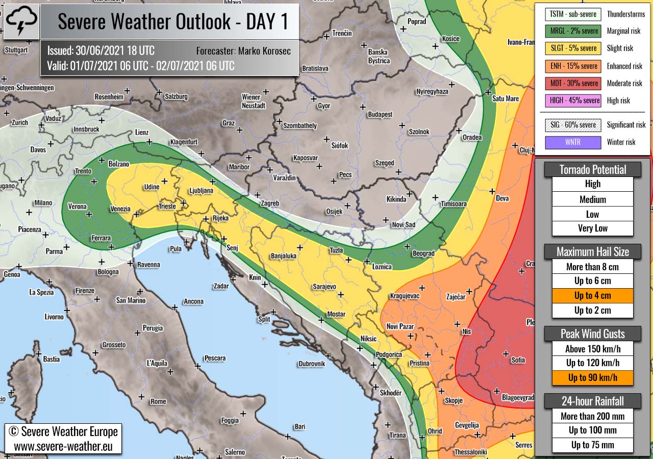
Highlighted severe weather threats:
- Maximum hail size: Up to 4 cm
- Peak wind gusts: Up to 90 km/h
An SLGT risk has been issued from northeast Italy into Slovenia, Croatia, Bosnia with threat for isolated severe storms capable of producing large hail, severe winds, and locally excessive rainfall. Beneath the large upper trough, diurnal heating will allow marginal instability to build up, while the wind field supports weak to moderate shear.
A few isolated supercells will be possible, bringing large hail and severe winds. Rather slow-moving storms will contribute to locally flash floods threat. With no defined frontal boundaries, storms will initiate in the hilly terrain first.
+++ other areas +++
MRGL risks have been issued for eastern and central Ukraine into southern Belarus, and also over parts of western Russia with an isolated threat for severe storms, capable of producing severe winds, marginally large hail, and torrential rainfall.
TSTM risks have been issued for the Pyrenees and northeast Spain, the Alps, Georgia and surroundings, and the Baltic region with a threat for daytime-driven thunderstorms. Limited shear is present in these areas, so the storms should remain sub-severe.
Follow & report severe weather events on our Facebook page:
Severe Weather Europe Facebook page
Understanding Severe Weather Outlook / Forecast for Europe
Severe Weather Outlook features areas of organized severe weather with risk levels and severe weather threats. Risk levels are divided into seven categories:
TSTM – Thunderstorms
MRGL – Marginal risk
SLGT – Slight risk
ENH – Enhanced risk
MDT – Moderate risk
HIGH – High risk
SIG – Significant risk
WNTR – Winter risk
Risk categories stand for the coverage and intensity of organized severe weather. Those could include supercells, squall lines, mesoscale convective systems, wind storms, flooding, snowstorms, or ice storms.
Severe weather threats include:
- large hail (of at least 2 cm in diameter)
- Tornadoes (including waterspouts)
- Wind gusts (convective or non-convective) above 25 m/s (or above 90 km/h)
- Torrential convective precipitation / Flash floods
- Excessive rainfall (100 mm within 12 hours) / snowfall (50 cm within 12 hours)
Extremely severe weather threats include:
- Large hail (of at least 5 cm in diameter)
- Tornadoes of F2 intensity or stronger
- Wind gusts (convective or non-convective) above 33 m/s (or above 119 km/h) or 12 Bft
- Torrential convective precipitation / Flash floods
- Excessive rainfall (150 mm within 12 hours or above ) / snowfall (above 100 cm within 24 hours)
Categories in the forecast represent the chance of severe weather occurring within a 40 km radius from a location. The used level is based on the conversion table of probabilistic risk into the outlook categories.
A threat level is upgraded into a higher category if probabilities meet the threshold criteria for the specific threat (e.g. tornado, wind, hail, or rainfall threat).
Each individual threat area includes a detailed forecast map and discussion on the potential of severe weather threats. Detailed weather forecast also includes probability levels for tornadoes, maximum hail size, peak wind gusts, and 24-hour rainfall.
Read more: Explanations for abbreviations (TSTM, SLGT, ENH, etc.)