A new large Saharan dust cloud is has moved out of Africa and into the Atlantic Ocean. It is currently heading towards the Caribbean, before landing over the southeastern United States early next week.
Strong thunderstorms and convective systems over Africa can create massive dust storms. In June, the pressure patterns and winds are favorable enough for these massive dust storms to reach the Atlantic Ocean and also far west towards the Caribbean and the United States.
SAHARAN AIR LAYER
Such large dust clouds are also called “SAL” (Saharan Air Layer). The Saharan Air Layer is a mass of very dry air, filled with desert dust that forms over the Sahara Desert during late spring, summer, and early autumn. It moves over the tropical North Atlantic every three to five days, with some events reaching very high volumes of dust and reaching far to the west.
The current satellite imagery below, reveals a strong Saharan dust event ongoing across the Atlantic Ocean. The GOES-16 satellite imagery below shows a large dust cloud moving over the eastern Atlantic Ocean on the morning of June 28th. It has left the African Continent and is making fast progress towards the west.

The visible satellite imagery from the evening of June 28th shows the dust cloud now closer to the eastern Caribbean, covering quite a distance in a few hours.
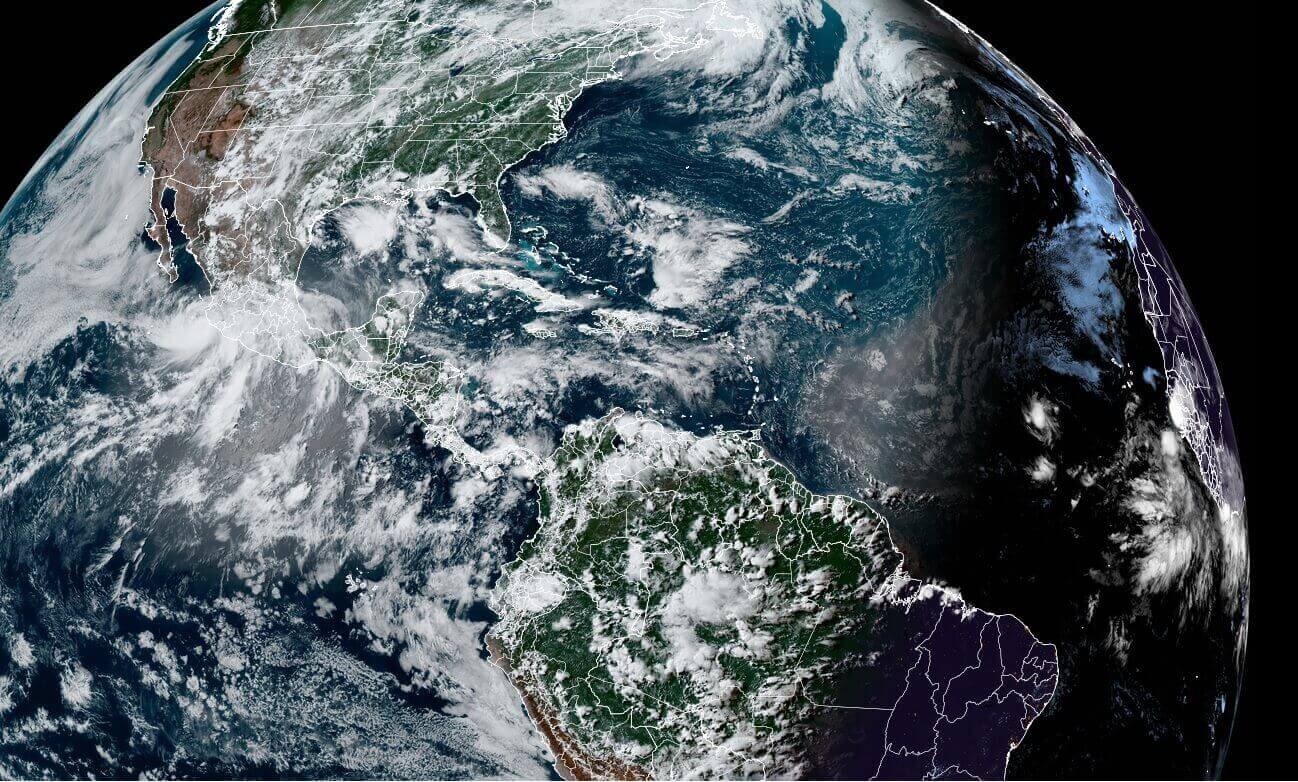
The satellite moisture analysis reveals the large dust cloud from another perspective. The bright pink colors highlight the large dust cloud extending from the Sahara Desert, west into the Atlantic, as a very dry area. Not all orange/yellow areas are dust clouds, but we know from the visible satellite above, where the dust particles can be found.

We produced a forecast animation, which shows the movement of this large dust cloud across the Atlantic in the coming days. The dust cloud will remain over the Caribbean till the end of the week, and extending towards the southeastern United States early next week.
The Saharan Air Layer is warm, stable, and very dry. It has about 50% less moisture than the typical tropical atmosphere. This warm and extremely dry air can weaken a tropical cyclone or a tropical disturbance and can prevent the formation of thunderstorms, which are important for tropical systems.
The satellite air moisture analysis below shows the large Saharan air layer as it is approaching the eastern Caribbean. It is reaching all the way back towards Africa.

Currently, there are now two tropical sytems over the Atlantic, one is right in the Saharan air layer in the central parts of the ocean. See details: Twin tropical disturbance over the Atlantic this week, hurricane season 2021 could soon see its 4th named tropical storm
Studies have shown, that iron-rich particles inside these dust clouds reflect sunlight and can cool the atmosphere. These fine particles also reduce the amount of sunlight reaching the ocean, which reduces the heating of the ocean surface, while the dust cloud is passing over.

Another massive dust plume has already reached the island of Aruba over 2 weeks ago, in mid-June, in the southern Caribbean. The image below by Jared Heil shows the dusty haze in the lower levels above the island. It was limiting visibility and affected the air quality.

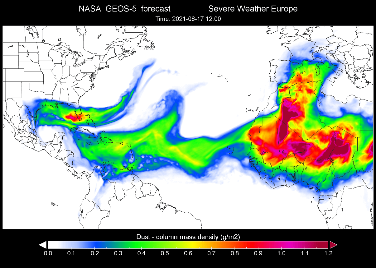
Below we have two graphics, which show the movement of this Saharan dust cloud two weeks ago, over the Atlantic, before reaching the United States around 3 days later, on June 17th.

While the dust cloud was already over the southeastern United States, a new dust cloud was preparing to leave western Africa, which is the current dust cloud, that you have seen on the satellite imagery above.
We will now look at the latest forecasts, and how the current dust cloud event will move over the Atlantic Ocean, before ultimately reaching the southeastern United States early next week.
SAHARAN DUST CLOUD FORECAST
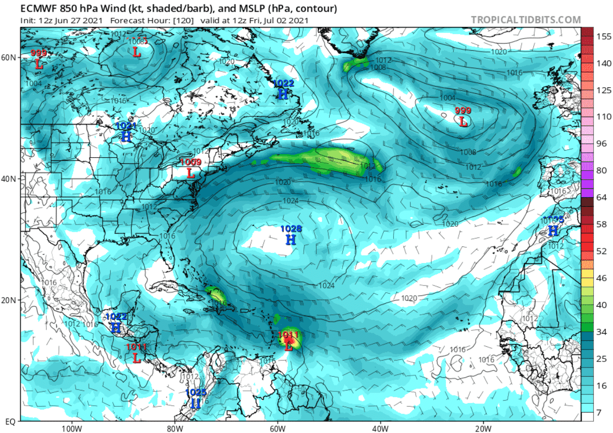
The persistent high-pressure system in the central Atlantic is the main steering mechanism for these dust storms. The easterly trade winds carry the dust clouds from Africa towards the west, sometimes reaching quite a large distance. Currently, there is no large anticyclone to be found on the image below, but we have 3 separate cores around a low-pressure system.

Below we can see the dust mass analysis from the NASA GEOS-5 modeling system. High concentrations of dust can be found in the main core of the dust cloud over Africa. The western leading edge of the cloud has not yet reached the eastern and central Caribbean.

The Saharan air layer is usually drier than normal tropical air, so we can track that on the relative humidity analysis in the image below. Drier air, associated with the Saharan air layer is extending from northwestern Africa towards the Caribbean.

By mid-week, the high-pressure system in the central Atlantic will pull back together, and emerge as one unit. That will help to amplify the easterly trade winds from western Africa, transporting a new dust cloud out into the Atlantic Ocean and over the Caribbean and the United States.

The dust forecast from the NASA GEOS-5 system shows the first dust cloud over the central Caribbean, slowly dissipating. The dust concentrations are low to moderate. A new dust cloud can be seen leaving western Africa, already almost reaching the eastern Caribbean.

Later this week, the high-pressure system will move slightly southwest, amplifying the circulation and the dust cloud transport speed. Notice a small low-pressure zone approaching the Winward Islands. That is a tropical system being forecast to develop this week.
The NASA GEOS-5 dust forecast shows the initial dust cloud moving over Cuba and into the Gulf of Mexico. The dust concentrations are forecast to be low at this point in that initial dissipating cloud. But the second dust cloud is already forecast to reach over the eastern Caribbean at this time, going slightly north with the main dust concentrations.

Early next week, the high pressure in the central Atlantic will weaken slightly. But the steering winds will remain stable and will shift the dust cloud directly towards the southern United States.

The first (weak) dust cloud is forecast to expand further up into the Gulf of Mexico. But the larger second dust cloud is rolling behind, with moderate dust concentrations. At this point, you can see a strong mass of dust slowly moving out of Africa, and into the Atlantic Ocean. That is a new large dust cloud being born.

A high-pressure zone is forecast to extend from the southeastern United states towards southwestern Europe by the middle of next week. This means that the steering winds will be favorable to push the dust cloud into the southeastern United States.

The NASA GEOS-5 dust forecast for the middle of next week shows the dust cloud over Florida and the rest of the southeastern United States. These are moderate concentrations, but the forecast can change in the coming days. You can see the new dust cloud already moving behind, slowly reaching into the eastern Caribbean.

2020 SAHARAN DUST EVENT
A similar dust event occurred last year, in late June. Below we have 3 images of this strong Saharan Air Layer event last season. The first image shows the view of the Saharan dust cloud over the Atlantic, as it was seen from the International Space Station in late June 2020.

The satellite imagery on June 25, 2020, revealed a dense dust cloud moving into the southern United States from the western Caribbean over the Gulf of Mexico.

The dust density analysis from the NASA GEOS-5 system showed quite high dust loading, as the Saharan air layer cloud reached the southeastern United States. The concentrations were higher than what is currently forecast for next week.

DUST CLOUD EFFECTS
Large dust clouds can cause a change in weather, as they bring drier and more stable air, which means less precipitation. Fine dust particles can also act as a natural fertilizer, so it is beneficial for the soil.
Saharan dust clouds also suppress tropical activity, which means a lesser risk for tropical storm intensification and landfall during its presence. Dust particles in the atmosphere also help to create beautiful, vivid sunrises and sunsets, as the dust particles scatter the sunlight.
On the negative side, fine dust particles can significantly reduce air quality, degrade vision, cause eye irritation, and can also cause sinus and respiratory problems. Fine dust particles can cause complications for individuals that already have respiratory problems if the dust is inhaled in higher concentrations.
We will keep you updated on similar nature and weather events around the world, so make sure to bookmark our page. Also, if you have seen this article in the Google App (Discover) feed, click the like (♥) button to see more of our forecasts and our latest articles on weather and nature in general.
SEE ALSO: