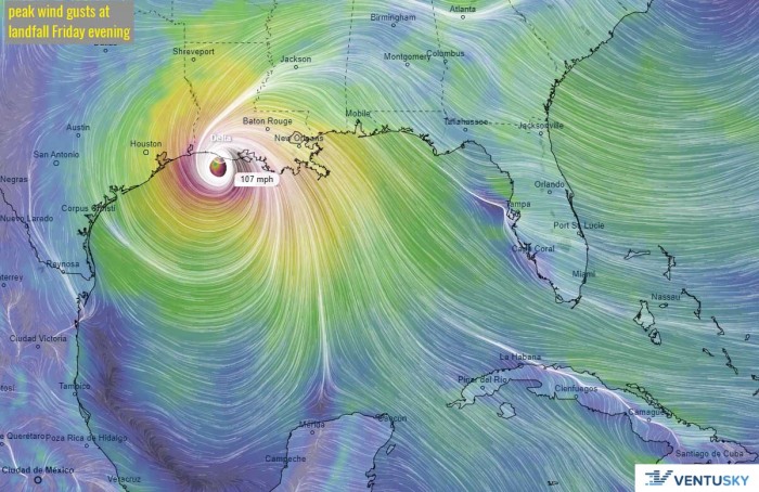
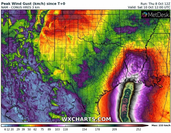
Hurricane Delta is now re-strengthening over the Gulf of Mexico, both satellite and NOAA aircraft data are indicating that a new rapid intensification is underway. Delta is now a major hurricane again, on track for a potentially dangerous and life-threatening landfall near Lake Charles, Lousiana on Friday.
Hurricane Delta grazed through the Mexican resort areas of Cozumel and Cancun on Wednesday where the storm knocked out power to 266,000 customers and resulted in severe damage.
Hurricanes usually have issues with significant re-intensification over the Gulf of Mexico, after they cross the Yucatan peninsula. But hurricane Delta was still developing hurricane on Wednesday with only a brief time over the land.
This allowed the storm to begin rapidly strengthening again on Thursday.
Delta is now on its way towards the historic, 10th landfall in the United States mainland this season. The landfall is expected in southern Louisiana on Friday evening.
Hurricane Delta will move over the *same* areas that have been severely damaged by Hurricane Laura in August.
Much of these areas have still not cleaned up and recovered before Delta arrives. Based on NOAA data, the last time two hurricanes strike western Louisiana in the same year was 1886.
A HURRICANE WARNING is in effect for High Island, Texas to Morgan City, Louisiana.
A STORM SURGE is in effect for High Island, Texas to Ocean Springs, Mississippi including Calcasieu Lake, Vermilion Bay, Lake Pontchartrain, Lake Maurepas, and Lake Borgne!
KEY POINTS
According to the National Hurricane Center advisory, there is…
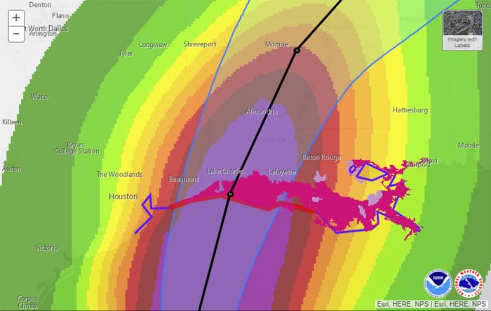
A life-threatening storm surge is expected near and east of where Delta makes landfall Friday, and a Storm Surge Warning is in effect from High Island, Texas, to Ocean Springs, Mississippi. The highest inundation of 7 to 11 feet is expected somewhere between Rockefeller Wildlife Refuge and Morgan City, Louisiana.
Residents in the warning area should promptly follow the advice given by local officials. The storm surge risk remains high despite the forecast decrease in intensity before landfall since Delta is expected to grow in size.
Hurricane-force winds are expected Friday afternoon and evening somewhere within the Hurricane Warning area between High Island, Texas, and Morgan City, Louisiana. Hurricane-force winds will also spread inland across portions of southern Louisiana near the path of Deltas center Friday evening and Friday night.
Heavy rainfall will lead to significant flash flooding and minor to major river flooding in parts of Louisiana Friday and Saturday. Additional flooding is expected across portions of the central Gulf Coast into the Lower Mississippi Valley.
RAPID INTENSIFICATION UNDERWAY
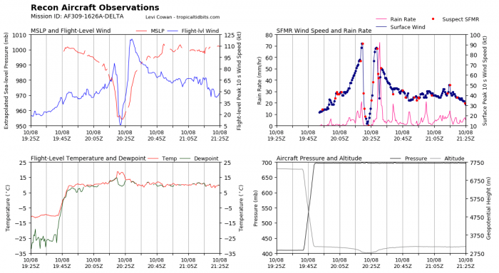
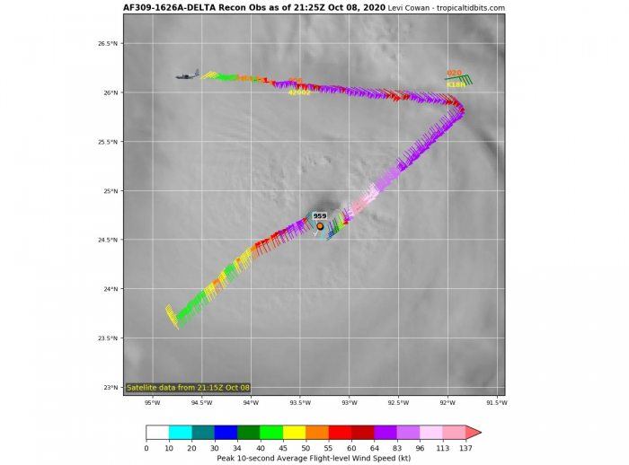
Both satellite observation and NOAA Hurricane Hunters aircraft observation reveal that hurricane Delta is strengthening again now. The satellite imagery indicates an eye is now seen in the cold cloud tops of the central dense overcast.
The latest Air Force Reserve Hurricane Hunter aircraft reported the 700mb flight-level winds of 119 kt. A dropsonde data revealed 90 knots surface winds and a central pressure of 959 mbar, inside a 30 nautical miles wide eye.
A blend of the flight-level and surface wind estimates give an initial intensity of 100 kt, so Delta has been upgraded to a major hurricane (Category 3).
The upper-level outflow ventilation is well-established across all four quadrants, with no sign of any dry air interrupting Delta’s strengthening.
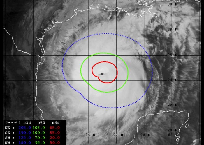
The Advanced Dvorak Technique (ADT) analysis estimates are indicating there are hurricane-force 64-knot winds spread within the 50-75 miles radii across the southeast, northeast, and northwest quadrants of the storm. While tropical-storm winds are extending 90-120 miles around the center.
The wind field of hurricane Delta is now significantly expanding, while the explosive development is visible per Dvorak analysis.
The rate of intensification over the past few hours is exceptional. Dvorak analysis is estimating that the central pressure could already be near 940 mbar with sustained winds of 120 knots – that would put Delta into a Category 4 in the Saffir-Simpson scale. The final T number is 6.2.
Hurricane Delta has intensified for around 30 knots over the past 6 hours, from 90 knots to 120 knots, based on Dvorak. This is a very explosive increase in winds!
LANDFALL IS EXPECTED IN LOUISIANA
Hurricane Delta will begin turning its track more northward and then northeast towards the United States Gulf Coast on Friday. The National Hurricane Center forecast that Delta will remain a powerful hurricane at landfall, most likely somewhere along the Louisiana coast (or the extreme upper Texas coast) on Friday evening.
Tropical-storm-force winds should begin in coastal areas of eastern Texas and Louisiana by Friday morning.
Low wind shear, very warm sea surface temperature of the Gulf of Mexico, and overall moisture conditions appear favorable for strengthening overnight, rapid intensification is likely to continue until Friday morning.
Delta will encounter slightly cooler water temperatures and lower ocean heat content prior to landfall while the global model guidance suggests that stronger southwesterly shear developing over the hurricane on Friday. These factors should limit significant intensification prior to landfall and likely lead to some weakening.
Rapid weakening is expected after landfall.
The video animation below indicates hurricane Delta is re-strengthening again, rapid intensification is underway. Delta is on the way for potentially destructive landfall with severe winds and life-threatening storm surge along the Louisiana coast!
LIFE-THREATENING STORM SURGE FOR LOUISIANA
Delta’s storm surge will be dangerous and life-threatening along the Louisiana coast.
The highest storm surge is expected across the immediate Gulf Coast of south-central Louisiana, but also in bays, inlets, and to some degree inland along rivers and bayous. Inundation could reach 7 to 11 feet above ground in these areas, according to the NHC.
As Delta is on a track similar to Hurricane Laura in August, a dangerous storm surge is also expected over the areas that were affected by Laura.
Based on the NOAA NHC forecasters, there is a life-threatening storm surge is expected near and east of where Delta makes landfall Friday, and a Storm Surge Warning is in effect from High Island, Texas, to Ocean Springs, Mississippi. The highest inundation of 7 to 11 feet is expected somewhere between Rockefeller Wildlife Refuge and Morgan City, Louisiana.”
HURRICANE-FORCE WINDS FOR LOUISIANA
The strongest winds with Delta are expected to be across south-central Louisiana, but also across the southwest Louisiana and extreme upper Texas coasts. These areas are likely to experience severe structural damage, downed trees, and power outages.
Hurricane-force winds are expected Friday afternoon and evening somewhere within the Hurricane Warning area between High Island, Texas, and Morgan City, Louisiana. Hurricane-force winds will also spread inland across portions of southern Louisiana near the path of Deltas center Friday evening and Friday night.
Delta is expected to rapidly weaken after the landfall, moving northeast across Louisiana. However, dangerous hurricane-force winds are still expected to spread well inland over much of Louisiana state through Friday night.
SIGNIFICANT RAINFALL THREAT
A significant rainfall and flooding threat will develop along the track of hurricane Delta during and after the landfall. Locally 5 to 10 inches (150-250 mm), with isolated 15 inches (400 mm) possible are expected with Delta across the southwest and south-central Louisiana. Flash floods and river flooding are expected.
Further inland, 4 to 10 inches (100-250 mm) are likely across parts of extreme eastern Texas, southern Arkansas, and also across the western Mississippi.
ANOTHER WAVE IN EASTERN ATLANTIC
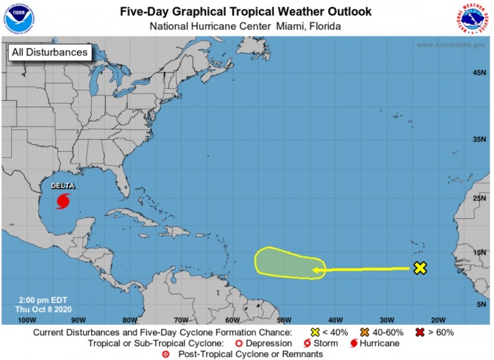
There is now some tropical activity also appearing in the far Eastern Atlantic, as a new tropical wave ejected the West Africa coast.
A vigorous tropical wave located a few hundred miles south of the Cabo Verde Islands is producing a large area of disorganized showers and thunderstorms, along with tropical-storm-force wind gusts.
This disturbance is expected to move generally westward at about 15 mph over the tropical Atlantic for the next several days.
The National Hurricane Center (NHC) is forecasting there is a 20 % chance for a tropical depression formation over the next 5 days.
Thinking of a nice Christmas gift for your friends, family or someone special to you? Weather calendar could be the perfect gift for them – see below:


