Model guidance is now in a much better agreement there will soon be not only one, but two tropical systems in the western Atlantic and the Caribbean. Atlantic is expected to generate a depression Epsilon over the next few days, while the Tropical Storm Zeta is likely to form near Jamaica late next week. Zeta could track towards the Bahamas and Florida.
The record-setting 2020 Atlantic hurricane season continues to produce more storms, Epsilon and Zeta are on the way. With the incoming MJO wave, atmospheric conditions are becoming much more favorable for tropical development, both the western Atlantic and the Caribbean Sea.
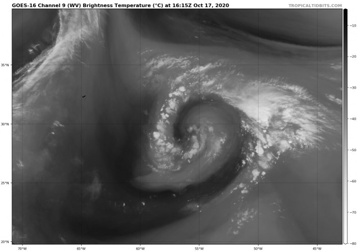
There is a large circulation ongoing to the southeast of Bermuda that is likely to become a tropical depression over the next 48 hours, as early as on Sunday.
Another, potentially more dangerous system slowly organizes in the western Caribbean and could become a concerning threat for Cuba and the Bahamas. Potentially even for the East Coast of the United States later this month.
The official hurricane season for the Atlantic Basin (the Atlantic Ocean, the Caribbean Sea, and the Gulf of Mexico) is from June 1st to November 30th. The peak of the season is from mid-August to late October.
By mid-October, the 2020 hurricane season still has about 45 days left until we close the books at the end of the season.
At the beginning of the hurricane season, NOAA, TWC, and NCSU forecasters predicted: “There will be 13 to 22 named tropical storms in 2020, where 6-9 of those would reach hurricane strength, and 3-4 of them attaining major strength.” The official name list had 23 names reserved this year.
As of Sept 18th, the list usage has been completed as all the reserved names were already used by that date. Since then, the Greek alphabet list is in use.
The next system from the list is Epsilon, then Zeta. Once they form, 2020 will have 27 storm names used. Zeta was the last Greek alphabet letter used for a named storm in the 2005 hurricane season.
The 2020 hurricane season is, therefore, very likely on the way for a new record for the most named storms in one season. Past 28 named storms from 2005 – the only year using the Greek alphabet until now. 2005 hurricane season churned out powerful hurricanes Katrina, Rita, and Wilma.
EPSILON LIKELY TO FORM IN THE ATLANTIC
According to the National Hurricane Center (NHC) 5-day tropical discussion, “Showers and thunderstorms are showing some signs of organization in association with a non-tropical low-pressure system located about 500 miles east-southeast of Bermuda.”
The system is located to the south of a large blocking high over the northwest Atlantic, so the steering flow will push it towards west-northwest while gradually strengthening over the next few days.
A subtropical* depression or storm is very likely to form during the next day or two. The NHC is giving the system a reasonably high chance (80 %) to become a non-tropical depression over the next 48 hours. And 90 % chance the system attains tropical characteristics over the next 5 days, it will be Epsilon.
*Typically, a subtropical storm has a large, cloud-free center of circulation. Strong thunderstorm activity is occurring in bands and is away from the center for at least 100 miles.
Tropical Storm Epsilon will, however, be no immediate threat to the United States East Coast. But it will generate high swells and rough surf towards the East Coast, the Bahamas, and northern coasts of Hispaniola, Puerto Rico, the Virgin Islands, and the Leeward Islands.
Below is the GFS model video animation of these tropical storms, Epsilon and Zeta, gradually forming in the coming days while intensifying. Epsilon in the tropical Western Atlantic and Zeta in the Western Caribbean. These are the 950 mbar sustained wind speed forecast for Epsilon and Zeta.
CARIBBEAN REGION IN FOCUS
The Western Caribbean region is closely monitored as the weather model guidance continues to forecast a potentially dangerous tropical storm (or even a hurricane) next week. Guidance is growing concerns that a broad area of low pressure – called a Central American Gyre – near Central America will begin developing.
The extremely warm Caribbean Sea waters are, combined with the strengthening upper-level divergence beneath the emerging MJO wave, conducive for tropical development near Jamaica.
Weather models hint an increasing thunderstorm activity, which could enhance the potential for the development of a new tropical storm towards Cuba, the Bahamas, and towards the East Coast of the United States over the next two weeks.
If indeed Epsilon forms in the Atlantic over the next few days, the 5th letter from the Greek Alphabet will be taken. Therefore, the Caribbean system would become a Tropical Storm Zeta when tropical-storm-force winds will develop.
While the globals model ECMWF is still rather uncertain regarding Zeta’s development, the other global model, GFS, is much more aggressive. GFS remains trending towards a strong tropical storm/hurricane over the western Caribbean late next week.
Until the system forms, it is well too soon to be sure about its future track. However, the GFS model keeps pushing Zeta across Cuba into the Bahamas. Then, it has two possible tracks – further northeast along the East Coast of the United States or even turning west towards Florida and the Gulf of Mexico.
However, if a more northerly trajectory takes place, that would definitely enhance the concern that the system could enhance the tropical threat for the Gulf Coast and the United States mainland at some point.
What is ‘Central American Gyre’?
This broad low-pressure area is officially called a ‘Central American Gyre‘, or shortly CAG). The attached graphics below, provided by Windy.com indicate such a Central American Gyre formation next week, while the sea waters of the Caribbean are extremely warm.
Central American gyres (CAGs) are broad lower-tropospheric cyclonic circulations occurring near Central America, in other words, a cyclonic gyre. They often form in response to the convectively active phase of the MJO (Madden-Julian Oscillation) over Central America.
On the intraseasonal scale, an active MJO wave can enhance westerly zonal winds in the eastern Pacific and promote convection over Central America, both then features that lead to a formation of the Central American Gyre development. CAG can yield exceptional rainfall amounts, leading to catastrophic flooding and large societal impacts in Central America.
There are several cases where these gyres lead to a tropical formation, for example, Tropical Storms Frances in 1998 and Nicole in 2010.
HOW IS THE HURRICANE SEASON SO FAR?
The Atlantic hurricane season has been a record-setting for named storms to date, Oct 14th. There were 25 named storms, which is nearly 250 % of the long-term average (10.2) for this time period. So far, there were almost double the number of hurricanes (9) and three major hurricanes (Laura, Teddy, and Delta). 23 storms out of those 25 total, had the earliest formation date on record.
Major hurricanes Laura, Teddy, and Delta have all peaked at Category 4 strength. Laura and Delta both made destructive landfalls in Louisiana. Delta’s center came ashore on October 9th and, interestingly, the landfall was just about 15 miles east of the landfall point of Hurricane Laura, which struck at the end of August.
Laura made landfall as a Category 4, while Delta was a Category 2 when it came ashore. The same areas were severely damaged by both storms.
The Atlantic, Caribbean region, the Gulf of Mexico, and the East Coast of the United States were also the most active tropical regions globally this year.
There have been almost 87 named storm days, which is around 176 % of the average number (49.2). As we can see from the graphics below (see the right column), all the forecast parameters are above average. Including hurricane days, major hurricanes, and major hurricane days. Provided graphics are by Dr. Philip Klotzbach.
Accumulated Cyclone Energy (ACE index)
The Accumulated Cyclone Energy is the energy output of a hurricane season, calculated as an index (ACE index). It is a metric used to express the energy used by a tropical cyclone during its lifetime.
The index calculation takes the cyclone’s maximum sustained winds every six hours and multiplies it by itself to generate the values. The total sum of these values is calculated to get the total for a storm.
The current Atlantic basin ACE is, as of October 12th, held at 123. That is almost 40 percent higher than during a normal season to this date.
The highest ACE so far this season was generated by Teddy (27.8), Paulette (15.9), Delta (15.7), and Laura (12.8).
But there is more. The 2020 Atlantic hurricane season has had a record-breaking 10 landfalls of tropical storms (or hurricanes) in the United States mainland this season. Hurricane Delta has helped the season to break the previous record of nine landfalling systems almost 100 years ago – in 1916.
Hurricane Delta was the first hurricane named after a Greek alphabet letter use which made landfall on the United States mainland. These are 10 named storms that made landfall in the continental United States this year (2020): Bertha, Cristobal, Fay, Hanna, Isaias, Laura, Marco, Sally, Beta, and Delta.
The 2020 hurricane season has also tied another record – there were 3 tropical storm formations in a single day. Tropical Storm Wilfred, Subtropical Storm Alpha, and Tropical Storm Beta formed on Sept 18th. This has happened only once before, in 1933.
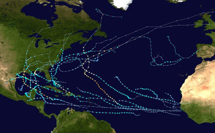
The graphics below show all the tropical storm tracks for the 2020 Atlantic Hurricane season so far. The image is provided by Wikipedia, based on the official data from the National Hurricane Center (NHC).
A NEW MJO WAVE WILL RE-EMERGE
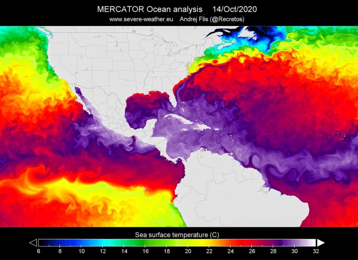
So, what can we expect for the rest of October 2020 hurricane season? The sea surface temperatures remain very warm in the Western Atlantic, and extremely warm over the Caribbean region. There, the sea surface temperatures are reaching about 30 °C (86 °F). Even around 31 °C (87 °F) around Cuba.
This is definitely a worrying sign as sea waters remain much higher than the long-term average. So the upcoming tropical systems will have the most important ingredient ready, therefore strongly supporting the rapid development of storms.
Actually, the majority of the North Atlantic, tropical Atlantic, and the Caribbean are well-above average. Also the Eastern Pacific. About 1-2 °C warmer, even more across the Northwest Atlantic.
There are some slightly cooler waters over the northern portions of the Gulf of Mexico and around Bermuda – this is the upwelling and cool Eddie left behind hurricanes Teddy, Laura, and Delta.
Notice also a rapidly cooling water of the Eastern and Central Pacific – a strong Lá Nina is developing. See details:
Incoming new MJO wave
The Madden-Julian Oscillation (MJO) is the largest and most dominant source of short-term tropical variability, it is an eastward-moving wave of thunderstorms, clouds, rain, winds, and pressure. It circles the entire planet on the equator in about 30 to 60 days.
At the end of October, a new wave will re-emerge from the eastern Pacific into the Caribbean region. It will also extend into early November.
The MJO consists of two parts: one is the enhanced rainfall (wet) phase and the other is the suppressed rainfall (dry) phase. This means there are increased storms and rainfall on one side and reduced storms and drier weather on the other side.
The air parcels are diverging (moving away) over the wet phase, and converging (moving together) over the dry phase. This horizontal movement of air is referred to as the Velocity Potential (VP) in the tropics.
We are able to track the entire MJO wave movement by looking at the larger scale air parcels movement. With the weather model data, we can easily see the areas where the air is rising and where it is subsiding.
Another important factor is the Ocean Heat Content (OHC). OHC takes into account the depth of the sea, and how warm the water layers are deep below the sea surface. In this month, we can still see a large pool of high available heat energy with a very warm water layer running down quite deep.
Deepwater being so warm as this season, provides a very favorable environment of a thick layer of warm water. Tropical systems are fueled by these warm layers, as deep convective storms draw energy from hot water.
Long story short: the thicker the warm layers are, the more fuel/energy is available to feed the storms.
The above graphics, provided by Michael J. Ventrice, Ph.D. represent an MJO wave with filtered VP200* anomalies for the current state, for the week 1 forecast, and for the week 2 forecast. Cold colors are representative of a more favorable state over the Atlantic for tropical cyclogenesis while warm colors represent a less favorable state for tropical cyclogenesis.
*VP200 – means a Velocity Potential (VP). It is an indicator of the large scale divergent flow, so at upper levels in the tropics. The negative VP anomalies (shaded blue in the diagram) are closely tied to the divergent outflow from enhanced convective regions.
It is an obvious sign that during the week 2 forecast (end of October), the MJO wave will emerge into the Caribbean region, lowering the pressure and providing a strong boost to thunderstorm activity.
HISTORY OF OCTOBER HURRICANES
With the typical October occurrence, more westerly prevailing winds are forecast to develop across the central and eastern United States. This tends to keep any potential tropical systems away from the western parts of the Gulf of Mexico.
Such steering winds and circulations more likely lead to the formation of the tropical systems over the Caribbean, moving towards the Bahamas and Florida, and further along the East Coast of the United States.
And late October has a history of some powerful hurricanes, originating from the Caribbean region and moving towards the United States, e.g. Sandy (2012), Wilma (2005), or Mitch (1998).
Also, Hurricane Michael, which made a destructive landfall as a Category 5 hurricane in Florida Panhandle on October 10th, 2018. Michael was the first Category 5 hurricane to strike the United States mainland since Andrew back in 1992.
The below map, based on the NHC past data, is showing where Atlantic named storms have formed over the second half of October (Oct 14th to 27th) during the satellite era (since 1966). It is an obvious fact that all the major hurricanes (Category 3 or greater) have formed in the central or western Caribbean Sea region.
In 2020, the Western Caribbean region greatly fit into the statistics, as both Tropical Storm Gamma and Hurricane Delta originated in the Caribbean.
The average trajectory of the tropical systems tracks in October is towards the north and northeast. This puts Florida at risk of landfall if storms organize. Actually, the month of October is the statistical peak of tropical storm landfalls in Florida.
So a typical October brings storm tracks closer to land, from the western Caribbean Sea to the eastern Gulf of Mexico, Florida, and also the East Coast of the United States.
RECORD YEAR WITH MORE THAN 30 NAMED STORMS?
Once the tropical storm Epsilon takes place, there will be only one name left to align with the existing record of 6 Greek alphabets used in 2005. Tropical Storm Zeta was the last storm name that was designated by the National Hurricane Center in 2005, the only year using the Greek alphabet prior to the 2020 Atlantic hurricane season.
Based on the current statistics, the Atlantic hurricane season 2020 is only three named tropical storms away from the record of 28 named storms in 2005. For example, the 2005 season had eight (8) additional storms forming in October itself and a few more later, even past the official end of the season.
With potentially a few more storms forming in November, we are definitely aiming towards Nu or Xi storm names. That is halfway through the Greek Alphabet names.
There seems to be a fairly high probability that the well-above-average western Atlantic and Caribbean region sea temperatures would be favorable for tropical storm formation even in December this year.
Nevertheless, there is still a long way to go before we will be closing the books of this historic 2020 Atlantic hurricane season.
Thinking of a nice Christmas gift for your friends, family or someone special to you? Weather calendar could be the perfect gift for them – see below:


