Although there has been a surprisingly calm period of the tropical cyclone activity in the Atlantic Basin since early July, the peak of the Atlantic Hurricane Season is approaching fast. Atlantic Ocean waters have anomalously warmed up, and while they also coincide with the emerging MJO wave from the west, the tropical activity will re-develop in the coming days.
And the latest NOAA seasonal outlook update calls for an even higher potential for an above-normal Atlantic hurricane season 2021. Let’s take a look what are the latest observations, trends, and forecasts for the upcoming weeks and months as the peak of the season is coming up.
While global weather is a very complex system of chaos theory, the weather dynamics and patterns are also very different around the world. The tropical dynamics are one of the more complex things with a lot of factors involving that all combined together then lead to dangerous tropical weather threats for the land and property.
The Atlantic Hurricane Season 2021 has started with an impressive and record-breaking activity, producing five named storms already at the beginning of July. And now a dramatic increase is likely to follow soon.
During an average year, the Atlantic hurricane season produces up to 14 named tropical storms. Where normally 7 of those become hurricanes, and around 3 of them reach the major strength (hurricane of a Category 3 or greater).

A typical Atlantic hurricane season has two peaks. The first one occurs in the early/mid-September while the second boost in the activity normally happens through mid-October.
The general increase in the activity across the tropical Atlantic normally begins in trough early/mid-August. And even statistically, the very first hurricane typically develops in mid-August, while this year Hurricane Elsa formed on July 2nd. Almost 45 days earlier than we would normally expect such an upgrade.
Then, a sudden change in the weather dynamic across the tropical region has occurred, completely shutting down the activity. There was barely any convective activity in the majority of the Atlantic Basin for almost a month. Until now.
As we are now heading into mid-August, the very warm Atlantic Ocean sea waters are about to coincide with the major and deep MJO wave, emerging into the Caribbean Region and the tropical Atlantic from the west. And at the same time, tropical waves ejecting from western Africa are being pushed into the eastern and central Atlantic
These waves have already bumped up two tropical disturbances moving west this week. One of these tropical waves is likely to become a named storm in the coming days. The next, 6th named storm of the Atlantic hurricane season 2021 would be a Tropical Storm Fred.
As the hurricane development is a very specific formation in the tropical region, it is strongly sensitive to atmospheric conditions present. The above-mentioned MJO wave has a major influence on the state of the atmosphere which allows tropical storms or hurricanes to develop.
They normally require a very warm sea temperature (26 °C or above), very high moisture present, low vertical wind shear through the atmosphere, and indeed a surface low-pressure system.
If these ingredients are in place, a tropical cyclone could quickly become a hurricane or even a violent, major hurricane when conditions are near perfect. There will likely be a strong influence of these factors throughout the coming weeks as we are nearing the peak Atlantic hurricane season this year.
We have prepared a high-resolution video animation of the Atlantic Ocean water temperature anomalies that are warming up significantly in recent weeks. Notice that the most important region (Main Development Region) is also becoming much warmer.
Unlike the mid-latitudes regions, the tropical region has no warm or cold fronts, so the weather activity is in general a combination of thunderstorms and larger scale pressure and wind variability. And most of the tropical variability is driven by invisible wave-like features in the atmosphere around the world.
The two most important waves are the MJO wave and the Kelvin waves. Which are the second and the third most needed ingredients after the warmth of the oceanic waters.
ATLANTIC BASIN IS VERY WARM, EVEN ANOMALOUSLY WARMER OVER THE TROPICAL ATLANTIC
The Atlantic Ocean sea surface temperatures (SST) are normally very warm through mid to late summer, and so are its temperatures this year. The recent sea surface temperature anomaly reveals that basically the whole Atlantic Basin has anomalously warmed up. Including the Caribbean, the Gulf of Mexico, and most of the Atlantic Ocean are warmer than normal.
The Atlantic Basin sea waters are the warmest in the western Caribbean region and the Gulf of Mexico. While the sea surface temperatures are from around 27-28 °C in the central tropical Atlantic, they are much warmer farther west. Up to around 30 °C in the northwestern Caribbean and even warmer in most of the Gulf of Mexico.
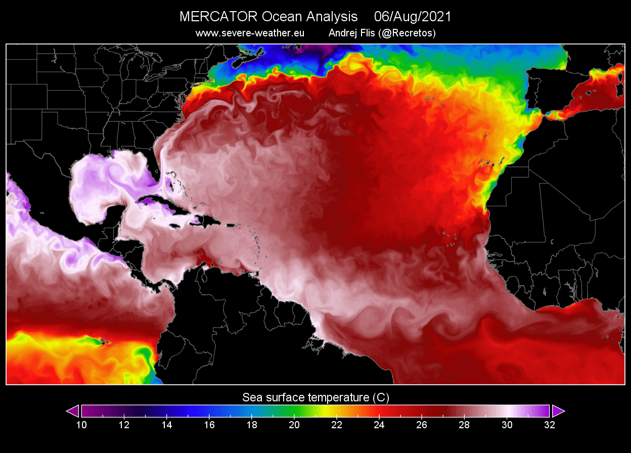
Water surface temperatures of 31 °C or even a tad warmer are observed over the western and central Gulf of Mexico. This is a very significant signal for the upcoming tropical storms that would track into these parts of the tropical region. The explosive development of tropical storms is often occurring when they encounter such a warm and moist fuel at the sea surface.
And thanks to the very calm weather across the tropical Atlantic in the recent weeks, the SSTs have also anomalously warmed, especially across the so-called MDR region (Main Development Region) between Africa and the Caribbean Sea.
Such temperature anomalies hint at the enhanced potential for significant tropical cyclone development since convective storms could easily fuel from the very warm tropical Atlantic ocean waters. And those will remain in place or even improve in the coming weeks and months, right for the peak of the Atlantic hurricane season.

Note that the current SSTs are quite typical when the August active Atlantic hurricane season follows.
INCOMING MJO WAVE – ATLANTIC HURRICANE SEASON BOOSTER
Recently, we are tracking a pretty significant MJO wave that is gradually emerging into the Caribbean region and the Atlantic Ocean from the west. It is expected to initiate tropical activity through the next few weeks and Atlantic Hurricane Season 2021 will likely catch up with the seasonal statistics that were surprisedly lower since Hurricane Elsa, the last active tropical cyclone in the Atlantic Basin, was active.
It is about a month since Elsa made landfall in the United States and dissipated between Iceland and Greenland as a post-tropical cyclone on July 9th. Then, the Atlantic Hurricane Season took a long break as there was no activity until this week. This is about to change very soon, thanks to very favorable conditions incoming into the Atlantic Basin – a deep MJO wave.
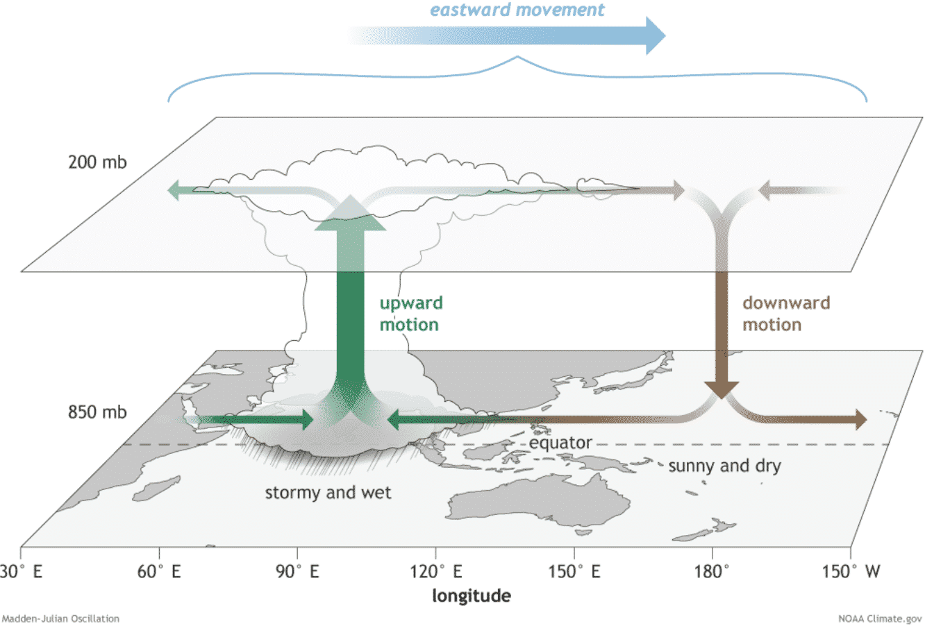
The MJO wave, known as the Madden-Julian Oscillation or short MJO, is a very important factor for tropical activity and cyclone formation. It is the largest and most dominant source of short-term tropical variability around the world. This eastward-moving wave of showers and thunderstorms typically circles the entire planet in about 30 to 60 days.
The chart below, provided by Michael J. Ventrice, represents the MJO wave with filtered VP200 anomalies for the current week state and the forecast for a week ahead. The blue colors (cold) mean more favorable conditions for tropical cyclone development, while the red colors (warm) are showing where a less favorable state for tropical cyclogenesis is present.
As we can quickly notice from the attached chart, there are favorable conditions over the Eastern Pacific, improving over the Caribbean and over the Atlantic Basin. Less favorable conditions are across the western Pacific Ocean and Indian Sea. This can directly tell us that conditions on both sides of central America are quite supportive of additional tropical development through mid-August.
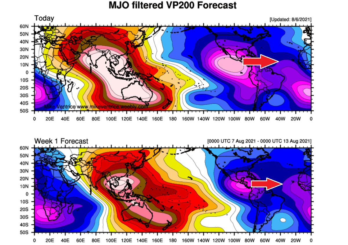
There were already two tropical cyclone formations in the Eastern Pacific recently, Tropical storm Hilda and Jimena, moving west towards the central Pacific this weekend. Both have formed under a deep MJO wave that was centered right above the Eastern Pacific Basin since the beginning of August. And another tropical cyclone is likely to develop over the Eastern Pacific next week.
Note: On the chart above, the VP200 indicates a Velocity Potential (VP) – this is an indicator of the large-scale divergent flow in the upper levels of the atmosphere over the tropical region. The blueish colors represent the negative VP anomalies and those are closely related to the divergent outflow from enhanced convective regions and often, if combined with low shear and high sea surface temperatures, this leads to tropical cyclogenesis.
The reddish colors, indeed represent the opposite, a converging flow aloft and suppressed convective activity. A deep MJO wave also brings a lower wind shear environment which is also another factor that helps to trigger tropical storm development.
Besides the MJO wave, there are other waves that are directly related to the large-scale wave as MJO is. Those are known as the atmospheric Kelvin waves and are smaller in size than the MJO. These waves are tropical rainfall systems accompanied by characterized westerly and easterly wind patterns.

The tropical Pacific experienced a downwelling (warming) Kelvin wave (marked by a dashed line) which reached the coast of South America in mid-June. The dotted lines above indicate upwelling Kelvin waves. When we have downwelling, Kelvin waves result in warming of the upper-ocean heat content while upwelling Kelvin waves result in the opposite, the upper-ocean heat content decreases.
ATLANTIC HURRICANE SEASON 2021 SO FAR
The Atlantic hurricane season 2021 began with similar activity to the last year, a very early start, and high activity. A Tropical Storm Elsa was the last active tropical system and also the strongest so far. It has formed on July 1st and just a day after, it became the first hurricane of the Atlantic hurricane season 2021.
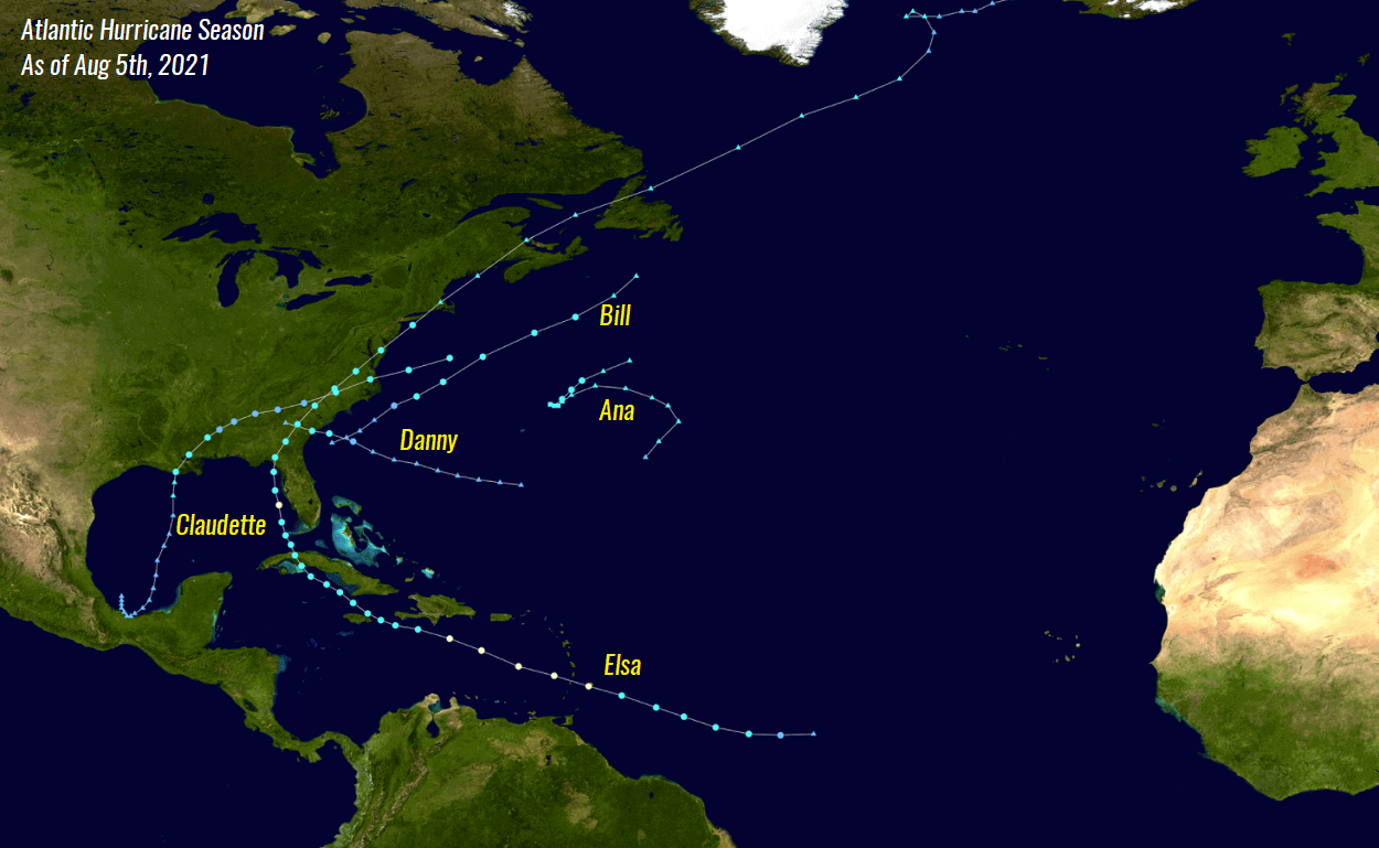
Elsa was also the farthest east that a hurricane has formed so early in the calendar year for the tropical Atlantic since 1933.
The World Meteorological Organization (WMO) has set a list of 21 tropical cyclone names that we are using for the Atlantic hurricane season 2021. The list has started with Ana and ends with Wanda. This list is used in rotation and re-cycled every 6 years. This means that the tropical storm names list of 2021 will again be in use in 2027.

Tropical Storm Ana
Tropical Storm Ana was the first tropical system forming in the Atlantic hurricane season 2021. Ana formed on May 22nd, about 10 days before the official start. The peak intensity of Ana was 45 mph with the minimum central pressure of the storm was 1006 mbar.
Tropical Storm Bill
The second named system was a Tropical Storm Bill. It has formed several hundred miles east off the coast of North Carolina and was active for only two days, from June 14 to 16th. It never had any land areas interactions as it remained over the open waters of the Northwest Atlantic with the peak winds intensity of 60 mph and a minimum central pressure of 998 mbar.
Tropical Storm Claudette
The 3rd named tropical cyclone was Tropical storm Claudette that has formed along the Mexico coast in the southwestern Gulf of Mexico on June 19th. Claudette has moved across the Gulf and made the very first landfall of any tropical cyclone of the Atlantic Hurricane season 2021 along the United States mainland about 36 hours later.

Claudette reached its peak intensity of 45 mph with a minimum central pressure of 1004 mbar while crossing the Gulf of Mexico prior to making landfall in southern Louisiana. After the landfall, Claudette was downgraded into a tropical depression while moving across the Southeast U.S. and ejecting into the Atlantic Ocean a few days later.
Tropical Storm Danny
On Monday, June 28th, a Tropical Storm Danny formed, the 4th named tropical cyclone which has shown that the Atlantic Hurricane Season 2021 means seriously with the term “above-normal” Atlantic hurricane season 2021. Although Danny lasted for a little less than 24 hours, it brought heavy rain and gusty winds at the time of landfall on the southwest South Carolina coast on the same day.

Tropical Storm Danny was also the 2nd tropical cyclone that made landfall on the US mainland, after Claudette. And also the first June landfall in South Carolina in more than 150 years, after Hurricane One in 1867.
Hurricane Elsa
Tropical Storm Elsa has formed in the western Atlantic on July 1st, then soon upgraded into a hurricane. Its peak intensity was 85 mph with a minimum central pressure of 991 mbar. With Elsa’s being upgraded to a hurricane on July 2nd, this was a remarkably 45 days earlier first seasonal hurricane formation in the Atlantic Basin, which is August 14th.

When it comes to monitoring the activity in the tropical region, we use it to express the energy that was used during the tropical cyclone’s lifetime. This is how we are able to compare every tropical storm or hurricane with the other. A so-called Accumulated Cyclone Energy (ACE index) was invented.
But what is the ACE index and how can we use it?
The ACCUMULATED CYCLONE ENERGY (ACE index)
As we see, the ACE index is an abbreviation for the Accumulated Cyclone Energy, or short: ACE. The index is used for all the tropical regions around the world. But as we focus on the Atlantic Hurricane Season here, lets take a look how the NOAA forecasters have set 4 categories to classify storms by the ACE index:
- Extremely active – ACE index above 152.5
- Above-average – ACE index above 111
- Near-average – ACE index between 66 and 111
- Below-normal – ACE index below 66
Just a brief look at those numbers might not tell us a lot, but let’s see a bit deeper what it actually means. For example, the whole record-breaking Atlantic hurricane season last year has had an ACE of 184.5, so looking at the thresholds above, it was quite well above the ‘extremely active’ category. The 2020 hurricane season was also among the 10 most active Atlantic hurricane seasons based on the ACE index.

The chart above indicates the Atlantic hurricane season statistics for the recent 15 years, including the final ACE value and also the number of hurricane formations.
So far, the Atlantic hurricane season 2021 has already generated 12.8 of ACE which is about 44% above the average through August 5th. Already five named storms also mean we are more than double the long-term average, the same with the named storm days.
A very fast start is obvious. And indeed, these numbers significantly increase as the tropical activity ramps up towards and during the peak of the Atlantic Hurricane Season.
UPDATED NOAA ATLANTIC HURRICANE SEASON OUTLOOK CALLS FOR EVEN MORE STORMS THAN INITIAL FORECAST
The Atlantic Hurricane Season 2021 has entered into its third month (out of 6 that typically occur in total every year). This week, there was a recent NOAA outlook update with a seasonal forecast for the Atlantic Hurricane Season this year. Just like the earlier outlook, the update also hints that the already above-normal and very active hurricane season will continue into this fall.
The NOAA’s Climate Prediction Center (CPC) says that a 65 % (it was 60 % in the initial outlook) chance of above-average activity remains in the forecast this year. NOAA forecasters are expecting 15-21 (13-20 was the earlier forecast) named storms. Indeed, this already includes the five named storms so far this season.
The recent outlook also hints that 7-10 hurricanes could develop and also 5 major (Category 3 or greater) hurricanes.
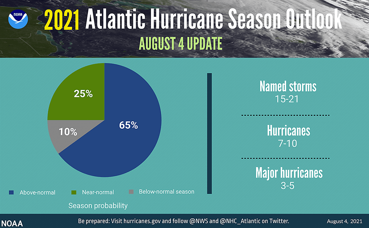
There is only a 10 % chance that a below-normal Atlantic hurricane season will occur this year and about a 25 % chance that normal season would develop.
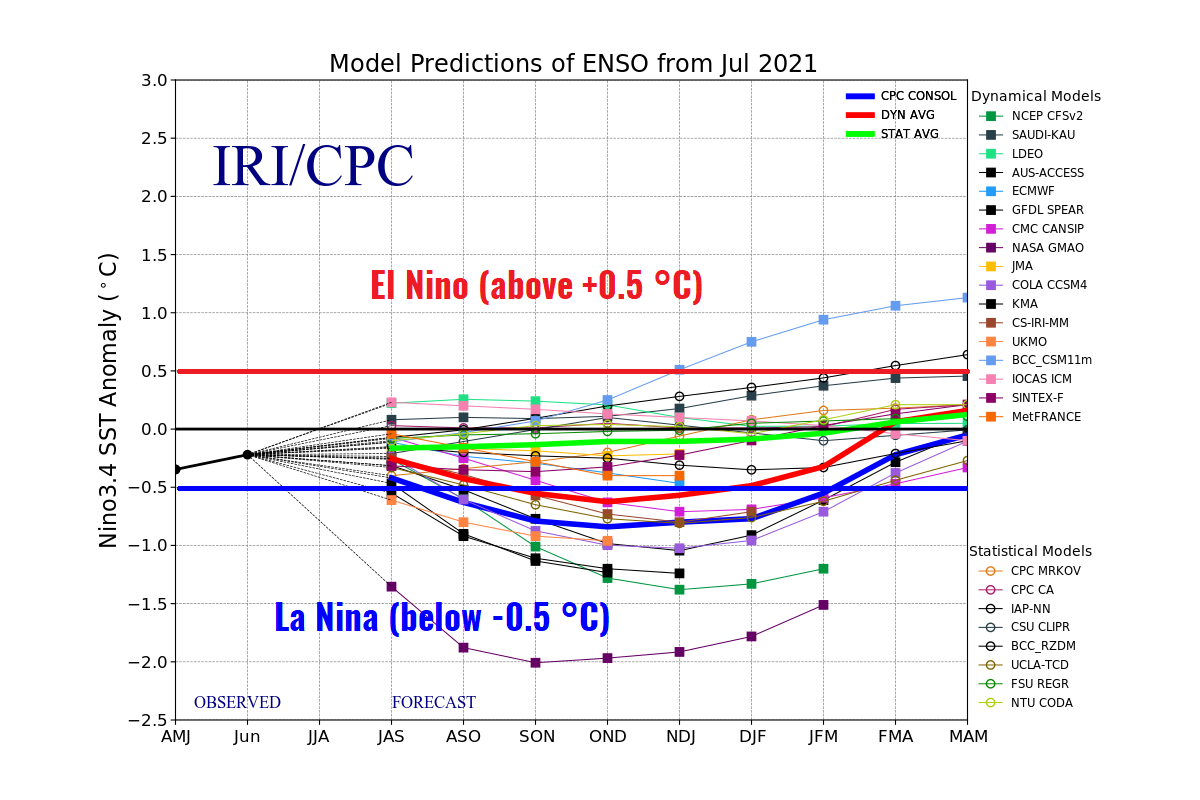
These forecasts are based on the recent changes in the Pacific Ocean waters, which are again cooling across its eastern and central parts. This means that neutral ENSO conditions might not be there for much longer as the cooling of the oceanic waters is forecast to continue throughout the peak of the Atlantic hurricane season 2021.
Recently, also the Colorado State University (CSU) has updated their seasonal outlook. According to dr. Phil Klotzbach, CSU predicts 18* named storms with the Atlantic hurricane season 2021. That is 25 percent (nearly 4 more named storms) more than an average hurricane season. The climatology data takes the period between 1991 and 2020.

Basically, all the parameters that are typically monitored during a hurricane season are likely to be above average again this year. CSU predicts about 80 named storm days (16 % above average), 8 hurricanes (11 % above average), and 4 major hurricanes (25 % above average).
The Accumulated Cyclone Energy (ACE) could reach about 150 which is 22 % above the normal for the 1981-2010 period.
*Note that the first 5 named storms this year are already included in the forecast.
So as we can quickly conclude from the chart above that the group of forecasters, led by dr. Klotzbach and NOAA are both forecasting a very serious outcome of the upcoming Atlantic hurricane season.
La Nina could re-develop in the following months and act as an additional booster to the tropical cyclone activity in the Atlantic Basin, including the Caribbean, the Gulf of Mexico, and also the impact to the United States mainland.
LA NINA COULD RETURN AND BOOST THE ATLANTIC HURRICANE SEASON 2021
There is a region of the ocean in the tropical Pacific, that we call it the ENSO region. ENSO is an abbreviation for El Niño Southern Oscillation and is alternating between warm and cold phases. Cold phases are called La Nina while warm phases are known as El Nino. ENSO has a major impact on the tropical activity and the complex interaction of the atmospheric and oceanic systems beneath.

During spring this year, the La Nina (cooler tropical central Pacific waters), which had a strong influence of the hurricane season 2020, has finished and a neutral ENSO phase was established. But as we are going through the final summer month, La Nina could come back to affect our weather again this fall, when the peak of the Atlantic hurricane season occurs.
Cooler than normal central Pacific Ocean waters usually lead to an above-average Atlantic hurricane season. Odds are very high that it will re-develop again in the coming months and likely remain throughout winter 2021/2022, according to NOAA’s latest ENSO update. ENSO watch has already been activated.
The ongoing and forecasted conditions hint that La Nina has now much higher changes to re-develop before 2021 is over. The sooner it develops, the higher influence it would have on the Atlantic hurricane season, as the peak normally occurs in September and October.
The weather patterns during the cooler tropical central and eastern Pacific waters are known to weaken the vertical wind shear across the Atlantic Basin. And as we remember from the discussion earlier above, the tropical cyclone or hurricane formations strongly depend on the wind shear between the ocean surface and the upper levels of the atmosphere. The lower the shear, the higher chances to get hurricanes.
NOAA forecasters also noted that this summer, there is an enhanced west Africa monsoon underway. This means that strong waves of thunderstorms are being pushed west into the Atlantic Ocean. That is where tropical development generally starts. Knowing these parameters, we could well assume that an active Atlantic hurricane season is coming up.
If interested in further details, take a look at our in-depth analysis of the ENSO patterns developing in the coming month as we head into the fall season: La Nina is returning for Winter 2021/2022, with a watch now issued for the ENSO region.
TROPICAL ACTIVITY RETURNS THROUGH MID-AUGUST
Until this week, a massive amount of SAL, known as the Saharan Air Layer was significantly limiting any thunderstorm activity over the tropical Atlantic. This layer contains a hot and dry air mass arriving from the Saharan desert which caps the vertical development of thunderstorms over the Atlantic. And this persistent layer of desert air directly leads to the shutdown of the tropical activity as we discussed earlier.
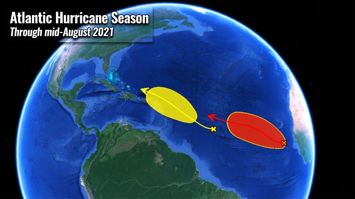
There are now two waves emerging into the eastern Atlantic and at least one of the two could be soon upgraded into a tropical depression or even a tropical storm in the coming days. They have both developed in the Main Development Region, soon after the strong thunderstorm activity ejected western Africa.

The first tropical wave contains a large area of disorganized cloudiness and thunderstorms. It is located a few hundred miles south of the Cabo Verde Islands. While it continues drifting west, the environmental conditions appear favorable for gradual development over the next several days.
A tropical depression could form towards the end of this weekend or early next week, it could even strengthen further and reach tropical-storm-force intensify while the activity moves generally west-northwestward across the tropical Atlantic.

The National Hurricane Center (NHC) is giving this activity a 30 % chance to become a tropical depression or 60 % chance to become tropical storm. The next reserved name from the WMO’s tropical cyclone list is Fred and it would be the 6th named storm of the Atlantic Hurricane Season 2021.
Farther west, a trough of low pressure is located over the central tropical Atlantic and is producing some disorganized showers and thunderstorms. While the system is expected to continue moving west-northwestward, some slow development is possible early next week as it approaches the Lesser Antilles. The National Hurricane Center is giving this activity a 20 % chance to become a tropical depression by then.
Residents of the coastal areas should always be hurricane aware, no matter the forecast.
Our team will be closely monitoring the further development of the Atlantic Hurricane Season and keep you up to date with every dangerous tropical cyclones that will develop. Stay tuned.