Outlook day 1 (valid: 24/04/2014)
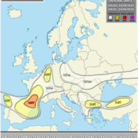
VALID FOR 24-04-2014 A ridge dominating pattern across Europe with large pressure centered over Scandinavia. The deep trough from the E Atlantic enters SW Europe …
VALID FOR 24-04-2014 A ridge dominating pattern across Europe with large pressure centered over Scandinavia. The deep trough from the E Atlantic enters SW Europe …
A new season is approaching. Meteorological spring will officially begin on March 1st and will last to May 31st. All the official weather statistics for …
As windstorm Xaver bears down on northern Europe, we take a look at windstorm Christian (or St Jude in the UK), which made headlines back …
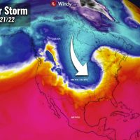
The second week of November will bring a significant winter storm that is forecast to spread across the Midwest and the central United States late …

Comet C/2012 S1 (ISON) is generating plenty of media attention and hype. Touted as the Comet of the Century, some spectacular and even outrageous claims …

Super Typhoon Haiyan has approached the Philippines with sustained winds of more than 310 km/h, while wind gusts were estimated up to 380 km/h. That …

Two days ago, when a strong upper trough transformed into the upper low over southern Mediterranean, numerous severe storms were on going over Greece and …

An intense surface cyclone with central pressure of 974 hPa is crossing western Europe today, resulting in damaging severe wind gusts across the south UK, …