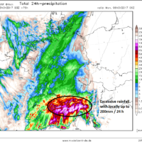
Excessive rainfall for S Alpine flank (N Italy, W Slovenia) on Sunday Nov 5th
A progressive pattern developing from western into central Europe this weekend will bring a deep trough towards the northern Mediterranean where a transition of a …
A progressive pattern developing from western into central Europe this weekend will bring a deep trough towards the northern Mediterranean where a transition of a …
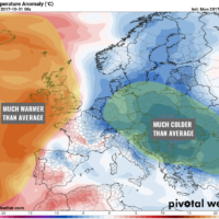
A period of very warm weather is ahead for a large part of the Arctic, with local temperature anomaly reaching +20 °C or more. While …
Intense rainfall is expected in parts of southern France and northwest Italy in the next 3 days. Locally, cumulatives may exceed 200 mm and significant …
Latest GFS model guidance indicates impressive warming in parts of the Arctic over the next 10 days, with temperature anomaly locally exceeding +20 °C, even …
With a developed strong pattern dividing Europe in two halfs, a very cold airmass behind a deep upper low moving across ESE Europe will spread …

An interesting pattern is developing across Europe with a strenghtening upper ridge across N Atlantic and western Europe while a very deep upper level low …
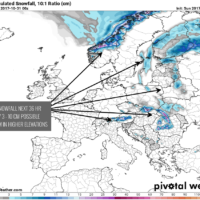
Latest GFS model guidance showing some fresh snow is likely to accumate across parts of eastern Europe in response to a very cold airmass advection …
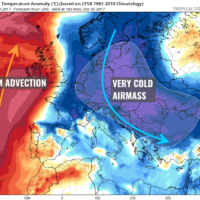
A powerful outbreak of cold airmass is spreading across east-central Europe today, associated with the very deep cyclone moving from Baltic States towards the Black …