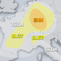
Outlook DAY 1 (valid: 25/04/2019)
Severe Weather Outlooks FAQ SYNOPSIS A deep upper trough / low is centered over WSW Europe while slowly drifting east. Strong upper ridge persists across …
Severe Weather Outlooks FAQ SYNOPSIS A deep upper trough / low is centered over WSW Europe while slowly drifting east. Strong upper ridge persists across …
The Saharan dust outbreak is spreading further north and east. We take a look at the extent of the dust cloud on Wednesday and Thursday. …
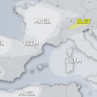
Severe Weather Outlooks FAQ SYNOPSIS An upper ridge remains over the eastern half of Europe while deep trough enters Iberian peninsula and the Bay of …
We take another look at the evolution and large extent of the current Saharan dust event across Europe. The following sequence of model maps in …
The cutoff low responsible for the big Saharan dust event is pushing northeast across the central and northern Mediterranean. It will also cause persistent combined …
Major amounts of Saharan dust are being pushed from north Africa across the Mediterranean into Europe. Large parts of Europe will be receiving significant amounts …
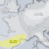
Severe Weather Outlooks FAQ SYNOPSIS A large upper ridge is centered over NNE Europe while deep trough with an intense cold core enters Iberian peninsula. …
As the strong dust event is currently ongoing over Europe, we are going to take a look at the state of the Atlantic ocean and …