Severe weather outlook – forecast across Europe. This forecast features areas of organized severe weather with risk levels and severe weather threats across the European continent.
SEVERE WEATHER OUTLOOK – DAY 1
Valid: 06/09/2020 06 UTC – 07/09/2020 06 UTC
Issued by: Severe Weather Europe
Forecaster: Marko Korošec
SUMMARY
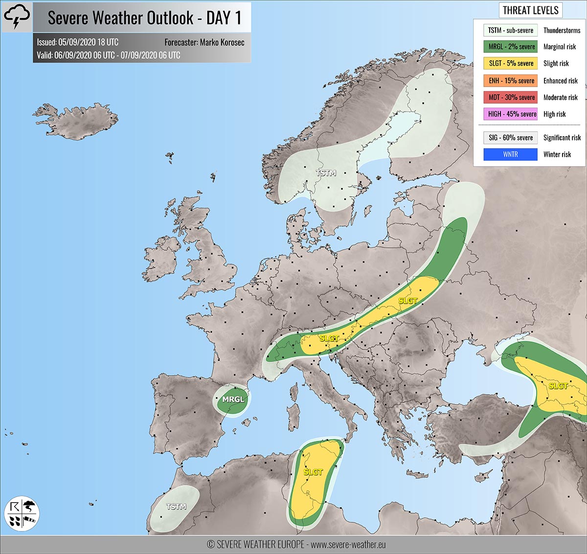
Severe storms with large hail, severe winds, and torrential rainfall are possible from northern Italy towards Poland and also over the eastern Black Sea region and Tunisia on Sunday. Supercells will be possible as well.
Overview of the risk areas across Europe
SYNOPTIC OVERVIEW
The North Atlantic upper ridge in strengthening while expanding into western Europe. Another ridge is strengthening over eastern Europe. In between, a long-wave trough is moving east while gradually losing its strength. Upper low sits over Tunisia, another one weakening over the eastern Balck Sea region.
FORECAST DISCUSSION
+++ Italy, Austria, Slovenia, Hungary, Slovakia, Poland, Ukraine and Belarus +++
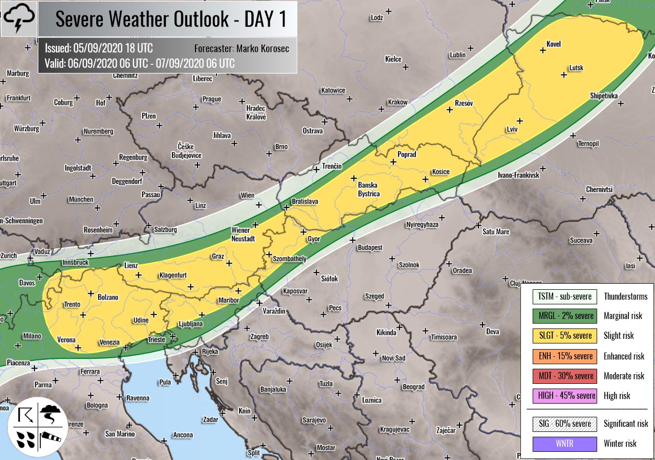
SLGT/MRGL risk has been issued for northern Italy across southern Austria and northern Slovenia into northern Hungary, Slovakia, southeast Poland, northwestern Ukraine, and Belarus with a threat for severe storms, capable of producing severe winds, torrential rainfall, and large hail.
Scattered organized storms are expected along the moving cold front across central and eastern Europe. Moderate shear coupled with weak to moderate instability should support isolated to scattered storms. Some of those could be supercells.
The strongest storms should bring severe winds and large hail threats. Storms will gradually continue east-northeast during the afternoon hours and could merge into a larger cluster in the nighttime.
+++ Black Sea, Ukraine, Russia, Georgia, Turkey and Armenia +++
SLGT risk has been issued for the eastern Black Sea, southwestern Russia, Georgia, eastern Turkey, and Armenia with a threat for severe storms, capable of producing severe winds, torrential/excessive rainfall, and marginal hail.
Another day under a decaying upper low will result in a rather widespread convective activity. Slow-moving storms are likely, so excessive rainfall threat will develop, posing threat for flooding. Moderate shear and instability should also support a supercell or two with large hail and severe winds threat.
+++ Tunisia and Sicily +++
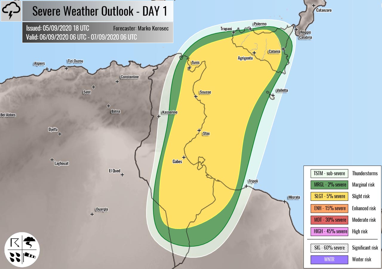
SLGT risk has been issued for Tunisia into Sicily with a threat for isolated severe storms, capable of producing severe winds, torrential rainfall, and large hail.
Convective activity will be associated with the weak upper low, so a rather widespread activity is possible. A few supercells could form, posing threat for large hail and severe winds under a strongly unstable and moderately sheared environment.
+++ other areas +++
MRGL risk has been issued for northeast Spain into the northwestern Mediterranean with a threat for isolated severe storms, capable of producing severe winds, torrential rainfall, and large hail.
A few isolated storms could form near the upper wave entering from the north, under a weakly unstable environment and moderate shear.
TSTM risks have been issued for Morocco, southern Turkey, and part of Scandinavia with a threat for daytime driven storms. Limited shear is present, so the storms should remain sub-severe.
Follow & report severe weather events on our Facebook page:
Severe Weather Europe Facebook page
Understanding Severe Weather Outlook
Severe Weather Outlook features areas of organized severe weather with risk levels and severe weather threats. Risk levels are divided into seven categories:
TSTM – Thunderstorms
MRGL – Marginal risk
SLGT – Slight risk
ENH – Enhanced risk
MDT – Moderate risk
HIGH – High risk
SIG – Significant risk
WNTR – Winter risk
Risk categories stand for the coverage and intensity of organized severe weather. Those could include supercells, squall lines, mesoscale convective systems, wind storms, flooding, snowstorms, or ice storms.
Severe weather threats include:
- large hail (of at least 2 cm in diameter)
- Tornadoes (including waterspouts)
- Wind gusts (convective or non-convective) above 25 m/s (or above 90 km/h)
- Torrential convective precipitation / Flash floods
- Excessive rainfall (100 mm within 12 hours) / snowfall (50 cm within 12 hours)
Extremely severe weather threats include:
- Large hail (of at least 5 cm in diameter)
- Tornadoes of F2 intensity or stronger
- Wind gusts (convective or non-convective) above 33 m/s (or above 119 km/h) or 12 Bft
- Torrential convective precipitation / Flash floods
- Excessive rainfall (150 mm within 12 hours or above ) / snowfall (above 100 cm within 24 hours)
Categories in the forecast represent the chance of severe weather occurring within a 40 km radius from a location. The used level is based on the conversion table of probabilistic risk into the outlook categories. A threat level is upgraded into a higher category if probabilities meet the threshold criteria for the specific threat (e.g. tornado, wind, hail, or rainfall threat).
Each individual threat area includes a detailed forecast map and discussion on the potential of severe weather threats.
Read more: Explanations for abbreviations (TSTM, SLGT, ENH, etc.)


