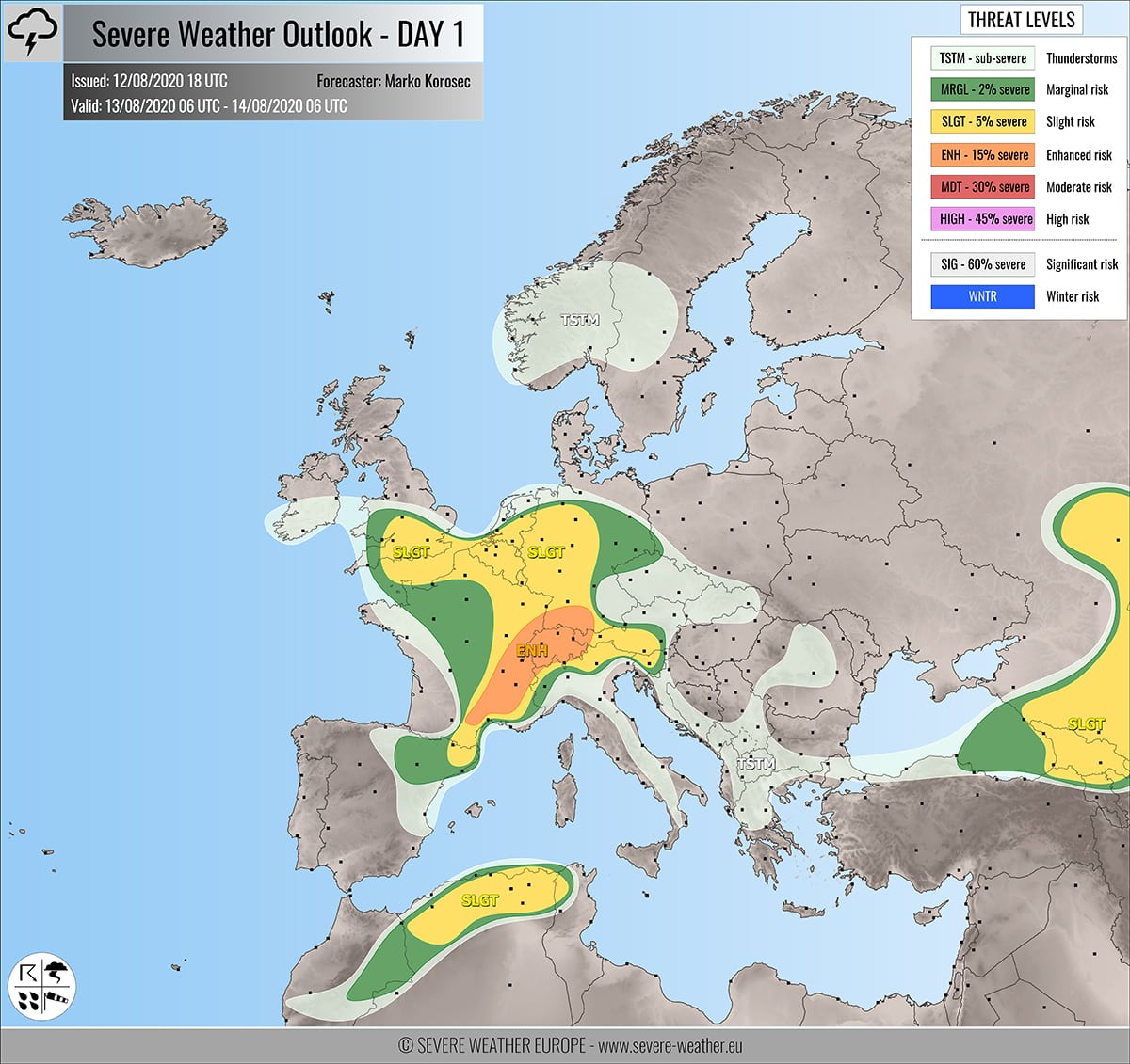
Severe weather outlook – forecast across Europe. This forecast features areas of organized severe weather with risk levels and severe weather threats across the European continent.
SEVERE WEATHER OUTLOOK – DAY 1
Valid: 13/08/2020 06 UTC – 14/08/2020 06 UTC
Issued by: Severe Weather Europe
Forecaster: Marko Korošec
SUMMARY
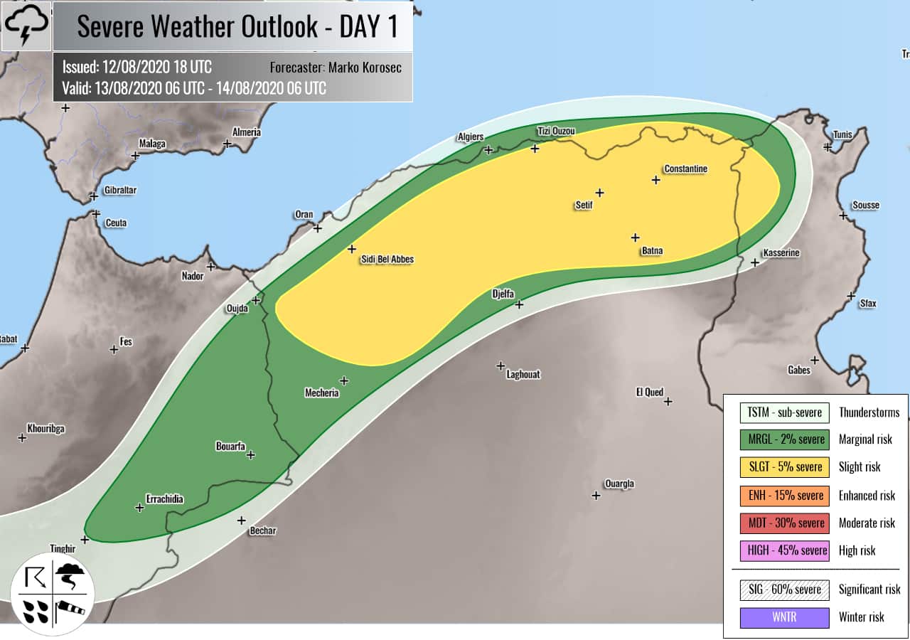
Severe storms with a threat for large hail, severe winds, and torrential rainfall with flash floods are again expected across France, Benelux, England, Germany, and across the Alps into western Balkans on Thursday. Severe storms are also expected along the cold front from the eastern Black Sea into Georgia, as well as over northern Algeria.
Overview of the risk areas across Europe
SYNOPTIC OVERVIEW
The upper ridging over Europe is gradually collapsing while a weakening upper low over France and the Bay of Biscay dissipates. Another deepening upper low approaches Iberia from the North Atlantic. The upper low across western Russia is expanding, with an associated surface cold front pushed towards Georgia.
FORECAST DISCUSSION
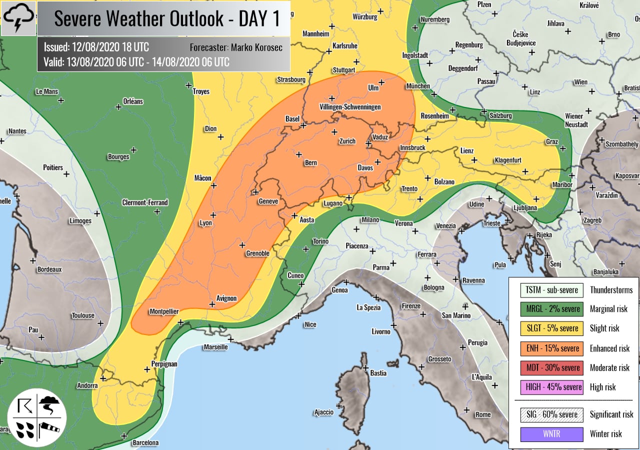
+++ France, Germany, Switzerland and the Alps +++
ENH risks have been issued for southeast France, Switzerland into southwestern Germany with a threat for severe storms, capable of producing severe winds, large hail, and torrential rainfall with flash floods.
SLGT risk has been issued for areas surrounding the ENH risk area including northeast Spain, eastern and southern France, Alpine region, and western Germany with more isolated threat for severe winds, torrential rainfall, and marginally large hail.
Moderately strong instability is again expected to build up across the forecast areas, under weak to moderate wind shear. Conditions should support scattered to widespread convective initiation by the early/mid-afternoon. Strong multicells and a few supercells are likely to form.
While the primary threats will be excessive rainfall and flash floods, some more intense storms should also enhance the threat for large hail and severe winds. Especially across southern France. Further north, slow-moving storms are expected and result in high rainfall sums.
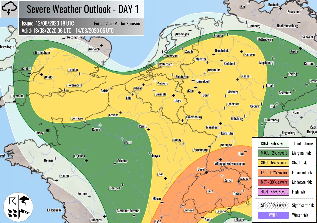
+++ France, Germany, Benelux into England +++
SLGT risk has been issued for east-northeast France across Benelux into west-central Germany, the English Channel into southern England with a threat for severe storms, capable of producing severe winds, marignally large hail, and torrential rainfall.
The decaying upper-level low brings another day of rather widespread convective storms. Moderate CAPE overspreads a weakly sheared environment. Mainly multicell storms and small clusters are expected, producing locally lots of rain and flash floods threat. Discrete storms could produce some marginally large hail. Again, storms could extend into the evening hours.
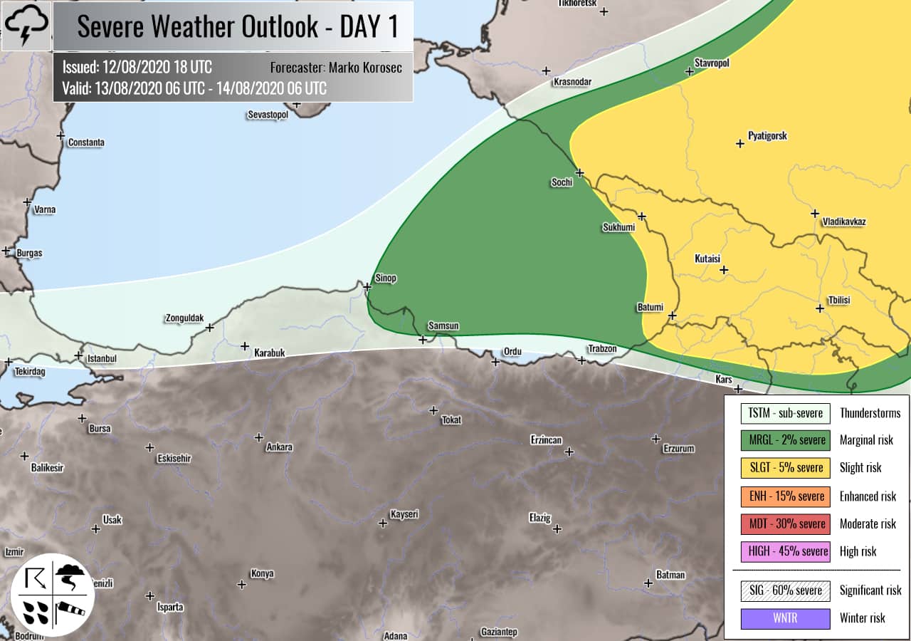
+++ southwest Russia into Georgia +++
SLGT risk has been issued for eastern southwestern Russia into Georgia with a threat for severe storms, including supercells along the moving col front. Those will be capable of producing torrential rainfall with flash floods, large hail, and severe winds.
A moderately instability and shear overlap along the moving cold front. An enhanced wind field rounding the strengthening upper low provides better shear for organized storms. Supercell storms are likely to bring large hail and severe winds.
+++ Algeria and Tunisia +++
SLGT risk has been issued for northern Algeria into northern Tunisia with a threat for a few isolated severe storms, capable of producing severe winds and large hail.
Activity will be related to the decaying upper low over southwestern Europe. Daytime heating should contribute to moderate CAPE and shear to support organized storms in the afternoon. A few isolated storms, including supercells, are possible with large hail, torrential rainfall, and severe wind threats.
+++ other areas +++
TSTM risk areas have been placed across Ireland, southwestern Scandinavia, Italy and the Balkans Turkey with a threat for daytime driven storms. Limited shear is present, so the storms should remain sub-severe.
Follow & report severe weather events on our Facebook page:
Severe Weather Europe Facebook page
Understanding Severe Weather Outlook
Severe Weather Outlook features areas of organized severe weather with risk levels and severe weather threats. Risk levels are divided into seven categories:
TSTM – Thunderstorms
MRGL – Marginal risk
SLGT – Slight risk
ENH – Enhanced risk
MDT – Moderate risk
HIGH – High risk
SIG – Significant risk
WNTR – Winter risk
Risk categories stand for the coverage and intensity of organized severe weather. Those could include supercells, squall lines, mesoscale convective systems, wind storms, flooding, snowstorms, or ice storms.
Severe weather threats include:
- large hail (of at least 2 cm in diameter)
- Tornadoes (including waterspouts)
- Wind gusts (convective or non-convective) above 25 m/s (or above 90 km/h)
- Torrential convective precipitation / Flash floods
- Excessive rainfall (100 mm within 12 hours) / snowfall (50 cm within 12 hours)
Extremely severe weather threats include:
- Large hail (of at least 5 cm in diameter)
- Tornadoes of F2 intensity or stronger
- Wind gusts (convective or non-convective) above 33 m/s (or above 119 km/h) or 12 Bft
- Torrential convective precipitation / Flash floods
- Excessive rainfall (150 mm within 12 hours or above ) / snowfall (above 100 cm within 24 hours)
Categories in the forecast represent the chance of severe weather occurring within a 40 km radius from a location. The used level is based on the conversion table of probabilistic risk into the outlook categories. A threat level is upgraded into a higher category if probabilities meet the threshold criteria for the specific threat (e.g. tornado, wind, hail, or rainfall threat).
Each individual threat area includes a detailed forecast map and discussion on the potential of severe weather threats.
Read more: Explanations for abbreviations (TSTM, SLGT, ENH, etc.)
