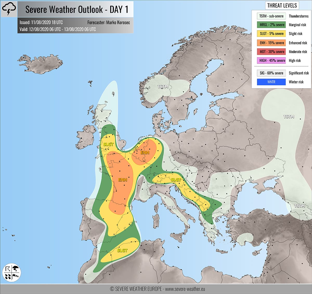
Severe weather outlook – forecast across Europe. This forecast features areas of organized severe weather with risk levels and severe weather threats across the European continent.
SEVERE WEATHER OUTLOOK – DAY 1
Valid: 12/08/2020 06 UTC – 13/08/2020 06 UTC
Issued by: Severe Weather Europe
Forecaster: Marko Korošec
SUMMARY
Widespread severe storms with a threat for large hail, severe winds, and torrential rainfall with flash floods are expected across Spain, France, England, Benelux, Germany, and across the Alps into western Balkans on Wednesday.
Overview of the risk areas across Europe
SYNOPTIC OVERVIEW
The upper-level low over southwestern Europe is gradually weakening while moving north-northeast on Wednesday. Another upper low is moving south across western Russia. In between, an omega blocking pattern persists across the southern, central, and northern Europe.
FORECAST DISCUSSION
+++ France, England, Benelux into Germany +++
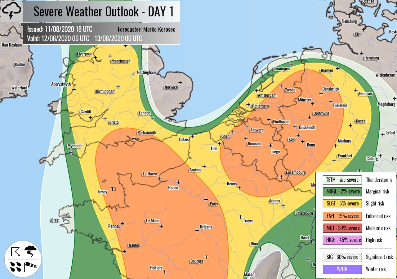
ENH risks have been issued for north-central France across the English Channel into southern England and across northeast France into Benelux and western Germany with a threat for severe storms, capable of producing severe winds, large hail, and torrential rainfall with flash floods.
SLGT risk has been issued for areas surrounding both ENH risk areas including England and Wales, France, Benelux, and western Germany with more isolated threat for severe winds, torrential rainfall, and marginally large hail.
Moderate to strong instability is again expected to build up across parts of western Europe with a marginal to the moderately sheared environment. Organized storms including strong multicells are likely to form as well. A few supercells are possible across the western ENH risk area.
Multicell storms with excessive rainfall and flash floods seem particularly dangerous across Benelux and western Germany where high rainfall sums are again possible. Slow-moving storms are expected to maintain over the same areas.
+++ Spain into southern France +++
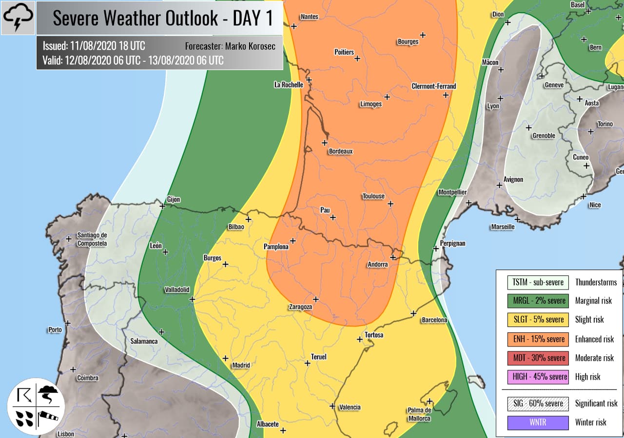
ENH/SLGT risks have been issued for east-northeast Spain into southern France with a threat for severe storms, capable of producing severe winds, large hail, and torrential rainfall.
The weakening upper low serves another day for robust severe weather across this region, as moderately strong instability couples with quite a strong shear. Scattered to widespread organized storms are expected, including supercells. Large hail and severe winds will be the primary threats. Storms could continue into the evening hours.
Storms will be more isolated across eastern Spain due to lack of large scale forcing, away from the main upper core.
+++ Alps and western Balkan peninsula +++
SLGT risk has been issued for eastern Switzerland, west-central Austria across Slovenia, Croatia, Bosnia and Montenegro with a threat for scattered severe storms, capable of producing torrential rainfall with flash floods, and some marginally large hail.
A moderately strong instability under weak shear should again support organized slow-moving severe storms, mainly multicells. Very heavy and excessive rainfall with dangerous flash floods is locally possible.
+++ Morocco and Algeria +++
SLGT risk has been issued for northeast Morocco into northern Algeria with a threat for a few isolated severe storms, capable of producing severe winds and large hail.
Activity will be related to the departing upper low over southwestern Europe. Daytime heating should contribute to moderate CAPE and shear to support organized storms in the afternoon. A few isolated storms, including supercells, are possible with large hail and severe wind threats.
+++ other areas +++
TSTM risk areas have been placed across southern Scandinavia, Scotland, Romania, Italy, Turkey, and western Russia with a threat for daytime driven storms. Limited shear is present, so the storms should remain sub-severe.
Follow & report severe weather events on our Facebook page:
Severe Weather Europe Facebook page
Understanding Severe Weather Outlook
Severe Weather Outlook features areas of organized severe weather with risk levels and severe weather threats. Risk levels are divided into seven categories:
TSTM – Thunderstorms
MRGL – Marginal risk
SLGT – Slight risk
ENH – Enhanced risk
MDT – Moderate risk
HIGH – High risk
SIG – Significant risk
WNTR – Winter risk
Risk categories stand for the coverage and intensity of organized severe weather. Those could include supercells, squall lines, mesoscale convective systems, wind storms, flooding, snowstorms, or ice storms.
Severe weather threats include:
- large hail (of at least 2 cm in diameter)
- Tornadoes (including waterspouts)
- Wind gusts (convective or non-convective) above 25 m/s (or above 90 km/h)
- Torrential convective precipitation / Flash floods
- Excessive rainfall (100 mm within 12 hours) / snowfall (50 cm within 12 hours)
Extremely severe weather threats include:
- Large hail (of at least 5 cm in diameter)
- Tornadoes of F2 intensity or stronger
- Wind gusts (convective or non-convective) above 33 m/s (or above 119 km/h) or 12 Bft
- Torrential convective precipitation / Flash floods
- Excessive rainfall (150 mm within 12 hours or above ) / snowfall (above 100 cm within 24 hours)
Categories in the forecast represent the chance of severe weather occurring within a 40 km radius from a location. The used level is based on the conversion table of probabilistic risk into the outlook categories. A threat level is upgraded into a higher category if probabilities meet the threshold criteria for the specific threat (e.g. tornado, wind, hail, or rainfall threat).
Each individual threat area includes a detailed forecast map and discussion on the potential of severe weather threats.
Read more: Explanations for abbreviations (TSTM, SLGT, ENH, etc.)


