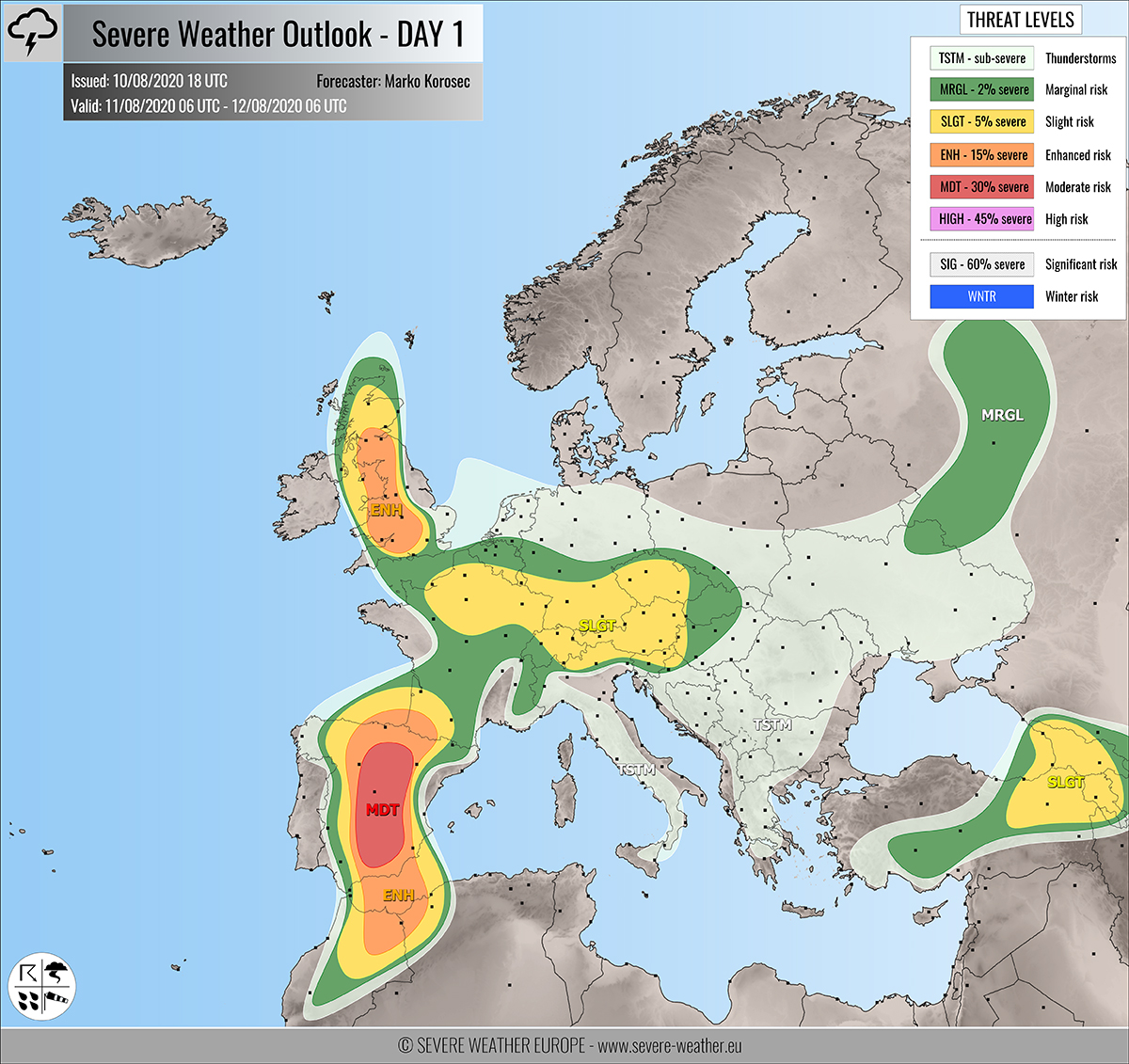
Severe weather outlook – forecast across Europe. This forecast features areas of organized severe weather with risk levels and severe weather threats across the European continent.
SEVERE WEATHER OUTLOOK – DAY 1
Valid: 11/08/2020 06 UTC – 12/08/2020 06 UTC
Issued by: Severe Weather Europe
Forecaster: Marko Korošec
SUMMARY
Robust severe storms with a threat for large to very large hail, severe damaging winds, and torrential rainfall with flash floods are expected across Spain, France, and the UK on Tuesday. Lots of storms also across central Europe.
FORECAST UPDATE
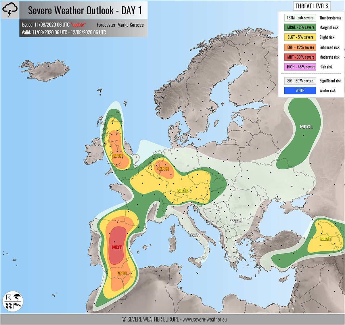
Part of Benelux and western Germany has been upgraded into ENH risk based on the recent model guidance improvement regarding the intensity and coverage of storms this afternoon. Rather widespread activity is expected.
+++ Benelux into western Germany +++
ENH risk has been issued for eastern Netherlands, eastern Belgium, northern Luxemburg and western Germany with a threat for excessive rainfall with flash floods and a lesser extent for severe winds and large hail.
Slow-moving storms are expected to deliver a lot of rain locally, which should significantly enhance flooding threat. High-resolution models are hinting 60-100 mm of rain is possible in western Germany. The most robust storm cores could result in some large hail as well.
PREVIOUS FORECAST…
Overview of the risk areas across Europe
SYNOPTIC OVERVIEW
An omega blocking pattern persists over Europe. A deep upper low is moving into the Iberian peninsula while another low is moving across western Russia towards the south. Another short wave is pushed towards Ireland and the UK from the west. At the surface, a frontal system is moving across western Russia and northeast Europe. A diffuse frontal system is moving across Iberia.
FORECAST DISCUSSION
+++ England, Wales and Scotland +++
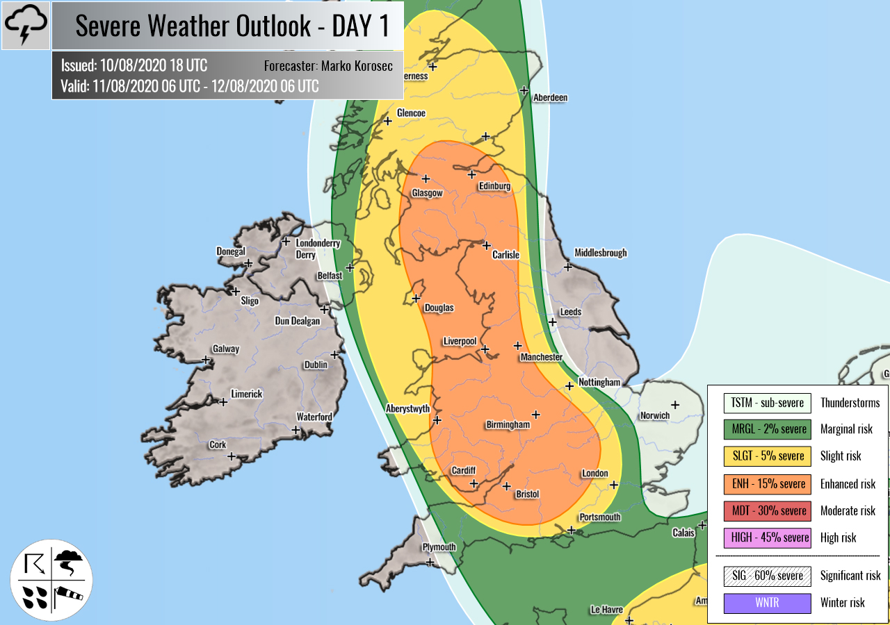
ENH risk has been issued for parts of England, Wales into southern Scotland with a threat for severe storms, capable of producing severe winds and large hail. Supercell storms are likely to form as well.
SLGT risk has been issued for areas surrounding the ENH risk including much of Scotland with a threat for isolated severe storms, capable of producing severe winds and marginally large hail.
Moderate to strong instability builds up during the peak time heating hours and overlaps with increasing deep-layer shear. A few isolated to scattered storms are likely to initiate in the afternoon. Favorable shear should allow storms to become organized while tracking north-northeast into the evening hours. A few large hail and severe wind events will be possible.
+++ Spain, Morocco and southwest France +++
MDT risk has been issued for central Spain with a threat for scattered to widespread severe storms, capable of producing severe winds, large to very large hail, and torrential rainfall with flash floods. Supercell storms are expected.
ENH/SLGT risks have been issued for areas surrounding the MDT risk area, including much of Spain into southwestern France, northern Morocco, and extreme southwest Mediterranean. Organized severe storms, capable of producing severe winds, large hail, and torrential rainfall are likely.
A deep upper-level low will be moving across the Iberian peninsula on Tuesday. Cool air aloft with strong surface heating should result in strong instability, potentially extreme along southeast Spain. Rapid destabilization is expected through the early/mid-afternoon hours. With moderate to strong shear (around 50 knots), robust storms are likely. Supercell storms could bring very large hail and severe damaging winds.
Some tornado potential is also possible along the southeast Spain (Andalusia, Murcia, and Valencia) where extremely unstable air mass couples with enhanced low-level shear and helicity.
+++ France, Germany, Switzerland, Austria, Czechia, Slovakia, Hungary and Slovenia +++
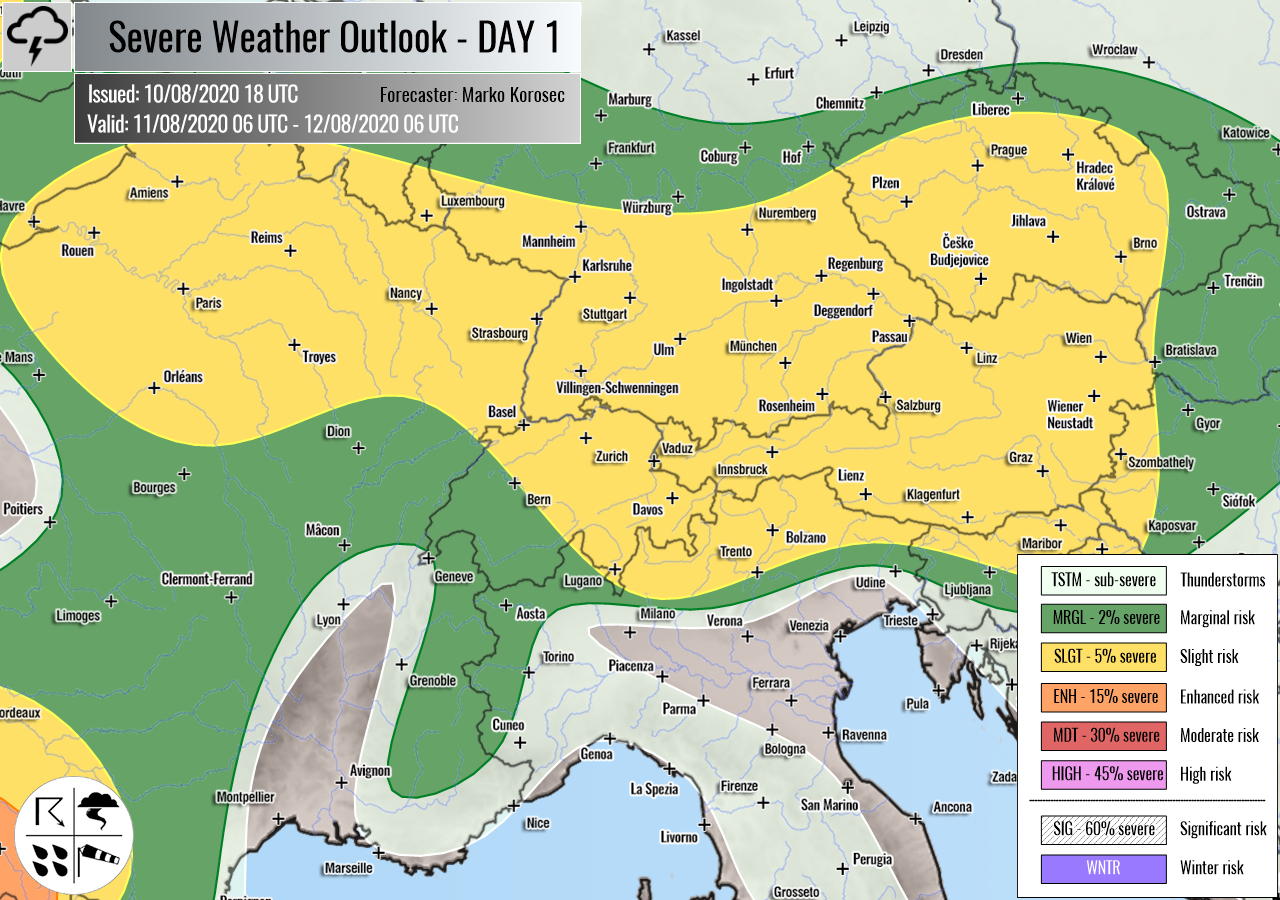
SLGT risk has been issued for northeast France, southern Germany, Czechia, eastern Switzerland, Austria, western Hungary into north-northeast Slovenia with a threat for scattered severe storms, capable of producing torrential rainfall with flash floods and marginally large hail.
A moderately strong instability under weak shear should support some organized slow-moving multicell storms with high rainfall sums. those could result in flash floods threat and some larger hail events.
+++ Turkey, Georgia and Armenia +++
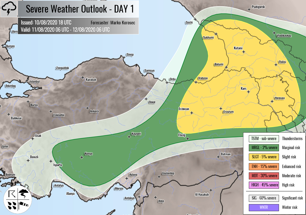
SLGT risk has been issued for eastern Turkey into Georgia and Armenia with a threat for a few isolated severe storms, capable of producing severe winds, large hail, and excessive rainfall.
Marginal instability within moderate deep-layer shear should support some severe storms. A few supercells will be possible, bringing large hail and severe winds. Persistent rainfall along the eastern Black Sea region could introduce dangerous excessive rainfall threat and flash floods.
+++ other areas +++
TSTM risk areas have been placed across the Balkans and Eastern Europe with a threat for daytime driven storms. Storms should remain sub-severe.
Follow & report severe weather events on our Facebook page:
Severe Weather Europe Facebook page
Understanding Severe Weather Outlook
Severe Weather Outlook features areas of organized severe weather with risk levels and severe weather threats. Risk levels are divided into seven categories:
TSTM – Thunderstorms
MRGL – Marginal risk
SLGT – Slight risk
ENH – Enhanced risk
MDT – Moderate risk
HIGH – High risk
SIG – Significant risk
WNTR – Winter risk
Risk categories stand for the coverage and intensity of organized severe weather. Those could include supercells, squall lines, mesoscale convective systems, wind storms, flooding, snowstorms, or ice storms.
Severe weather threats include:
- large hail (of at least 2 cm in diameter)
- Tornadoes (including waterspouts)
- Wind gusts (convective or non-convective) above 25 m/s (or above 90 km/h)
- Torrential convective precipitation / Flash floods
- Excessive rainfall (100 mm within 12 hours) / snowfall (50 cm within 12 hours)
Extremely severe weather threats include:
- Large hail (of at least 5 cm in diameter)
- Tornadoes of F2 intensity or stronger
- Wind gusts (convective or non-convective) above 33 m/s (or above 119 km/h) or 12 Bft
- Torrential convective precipitation / Flash floods
- Excessive rainfall (150 mm within 12 hours or above ) / snowfall (above 100 cm within 24 hours)
Categories in the forecast represent the chance of severe weather occurring within a 40 km radius from a location. The used level is based on the conversion table of probabilistic risk into the outlook categories. A threat level is upgraded into a higher category if probabilities meet the threshold criteria for the specific threat (e.g. tornado, wind, hail, or rainfall threat).
Each individual threat area includes a detailed forecast map and discussion on the potential of severe weather threats.
Read more: Explanations for abbreviations (TSTM, SLGT, ENH, etc.)

