A powerful earthquake swarm continues on the Reykjanes Peninsula, Iceland since February 24th. Over 20.000 earthquakes have now been detected since the beginning of the earthquake swarm.
As the series of strong earthquakes continues, more signs of magma movement are also being detected. This has prompted the officials monitoring the situation, to raise the alert level from yellow to orange.
WHERE FIRE MEETS ICE
Iceland is most known as a volcanic island in the North Atlantic. It is one of the most active volcanic regions in the world. As history shows, its eruptions can sometimes have powerful impacts on Europe and the entire Northern Hemisphere.
It has constant earthquake activity because it sits on both the Eurasian and North American tectonic plates. The plates are moving away from each other, tearing the island apart. It is the only place in the world where you can see those two tectonic plates and the Mid-Atlantic Ridge above ground.
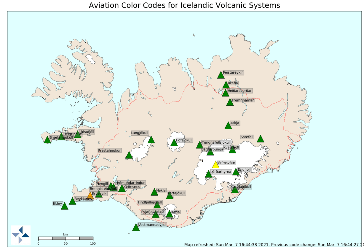
On the image below, you can see where the spreading Mid-Atlantic ridge is passing through Iceland (orange strands). It enters in the southwest on the Reykjanes Peninsula, going towards the east, where it then turns north. Main volcanoes are marked in red.

The region of main activity recently is the Reykjanes Peninsula. You can see it marked on the image above, at the western tip, where the Mid-Atlantic ridge enters Iceland.
ONGOING EARTHQUAKE SWARM
The current earthquake swarm began on February 24th. The strongest earthquake in the initial swarm had a 5.7 magnitude. There were also numerous M3 and M4 earthquakes in that swarm and many strong aftershocks. The shaking was strongly felt all the way to the capital Reykjavik.
Below is a video animation, which shows the earthquake sequence in the first days of the earthquake swarm. It covers the period from February 23rd to March 2nd. You can really see strong bursts of earthquakes and quite violent ground-cracking activity.
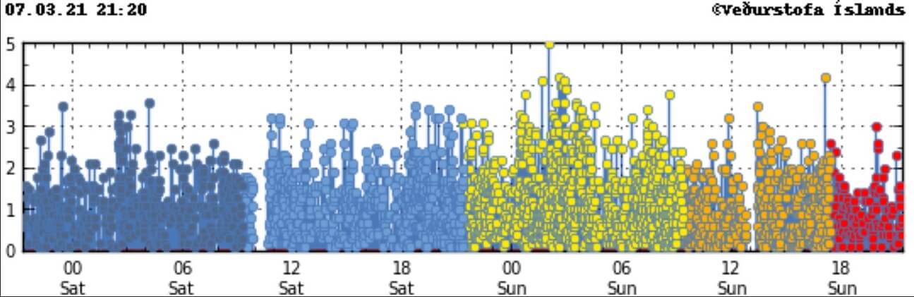
The earthquake swarm is currently ongoing. The graph below shows the earthquake activity on the peninsula in the past 2 weeks. Since the onset of the main swarm on February 24th, the earthquakes continue, with frequent magnitude 4 and 5 earthquakes.
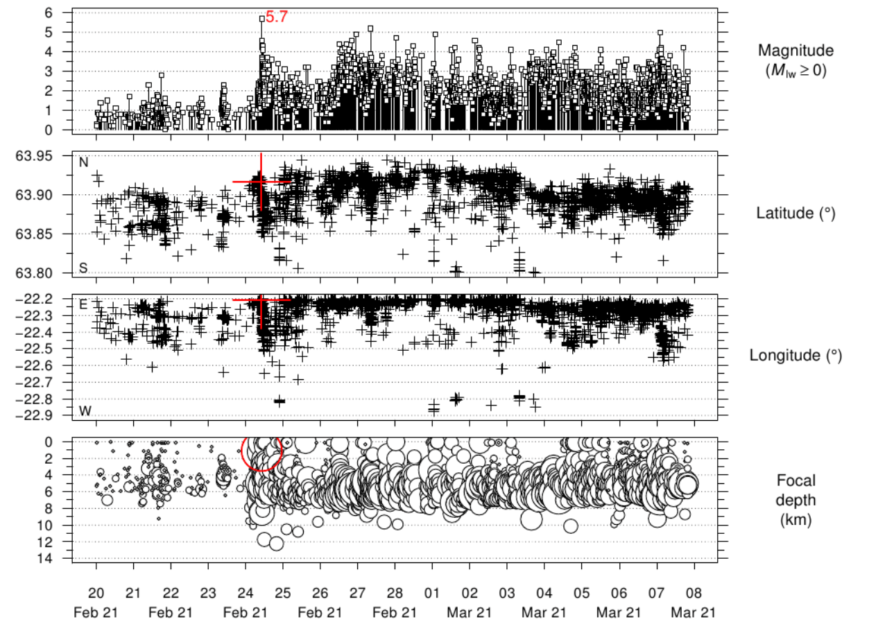
More than 20.000 earthquakes have now been recorded with the Icelandic Meteorological Office’s automatic seismic measuring system since the swarm began.
The initial swarm had strong magnitude earthquakes spread out, focused into two clusters. Cluster 1 is associated with the Fagradalsfjall volcanic system, and cluster 2 is associated with the Krysuvik volcanic system.
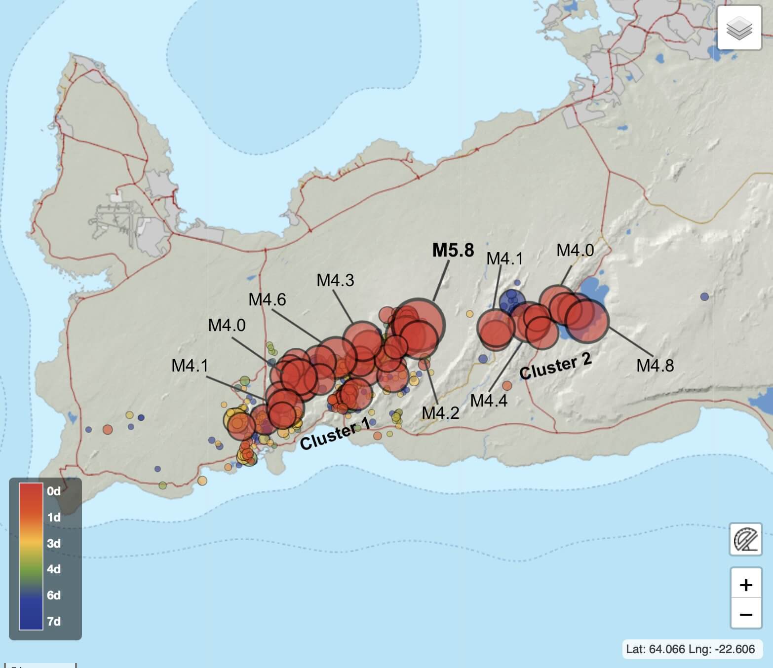
By February 27th, the main earthquake activity was focused on the west cluster in the Fagradalsfjall volcanic system. Frequent magnitude 4 earthquakes were detected. Shaking from the stronger earthquakes was felt across the region, all the way to the capital Reykjavik.
EARTHQUAKE SWARM CONTINUES
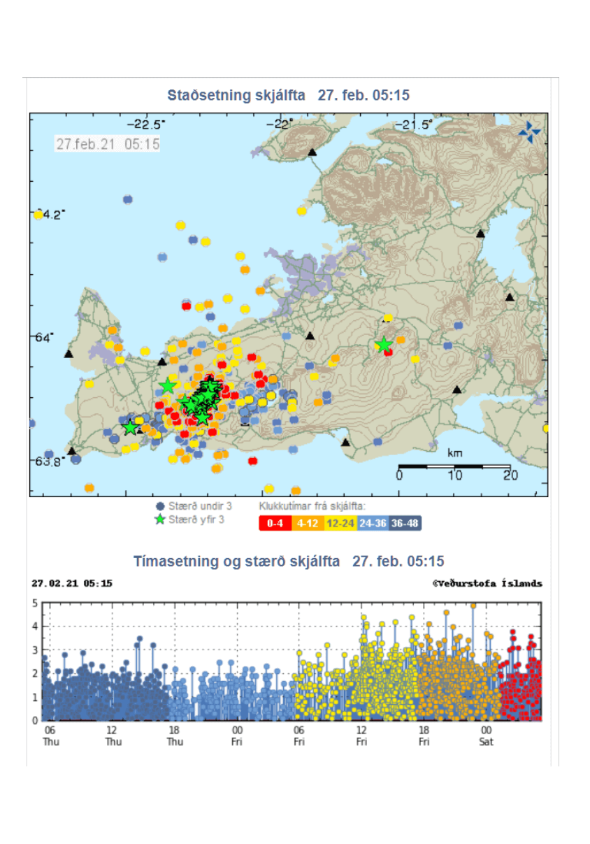
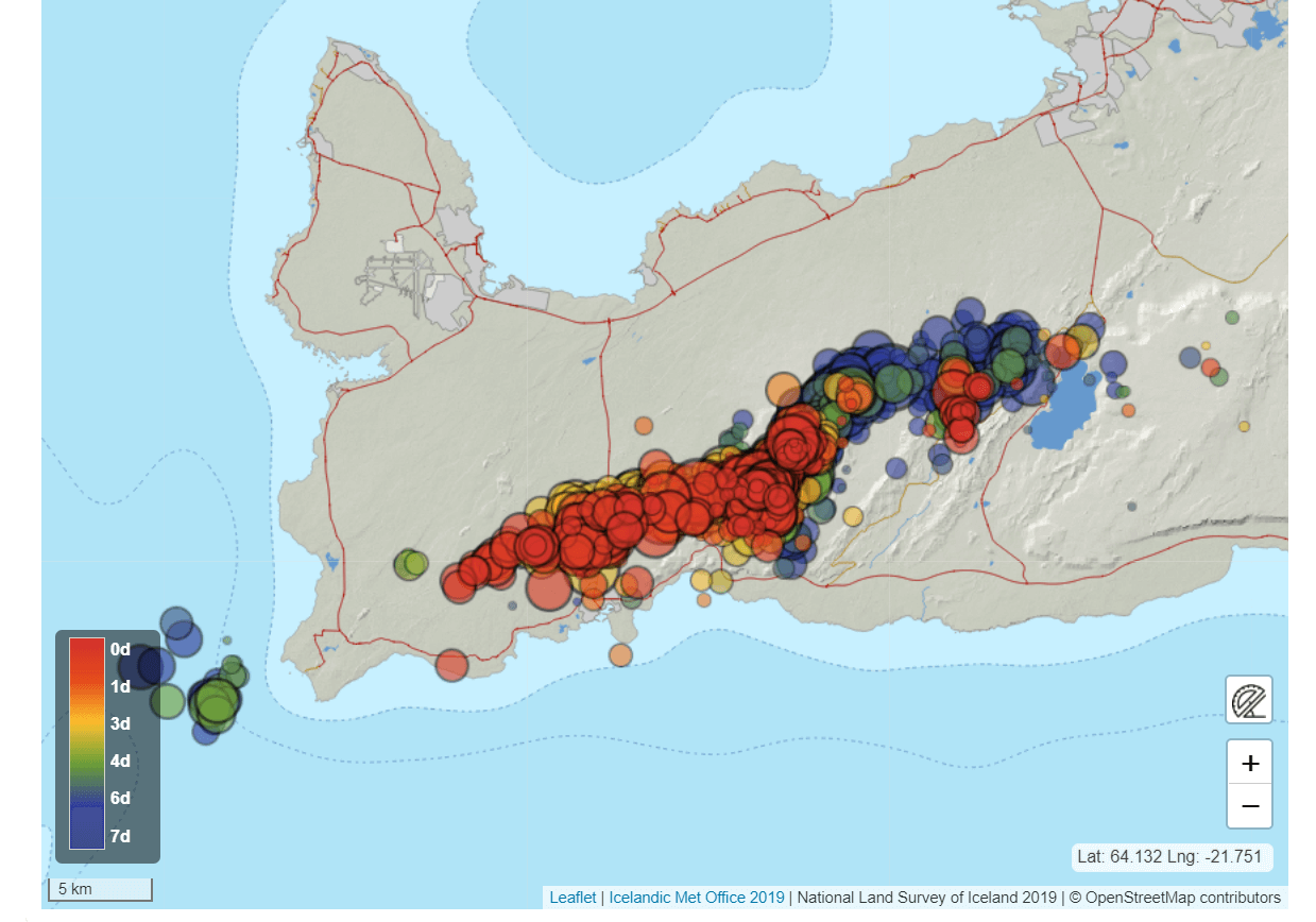
Currently, the earthquake is still going strong. Below we have the earthquake locations and magnitudes for March 6th and 7th. Another magnitude 5 earthquake was detected just after midnight on Sunday, 7th March. Compared to the previous image, we can see that the earthquake swarm is not more linearly spread out, along the mid-Atlantic ridge.
Below we have an image that shows the strongest earthquake activity and locations over the past 7 days. You can see the more recent activity (warmer colors) has shifted more towards the west, oriented along the main fissures.
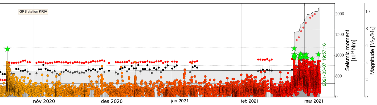
The earthquake analysis for the past months shows that this region is under constant shaking. There was a magnitude 5+ earthquake here in October, but the activity calmed down to normal levels. You can see the latest earthquake swarm at the end, and just how powerful it is compared to the previous activity, releasing more energy than last decades here combined.
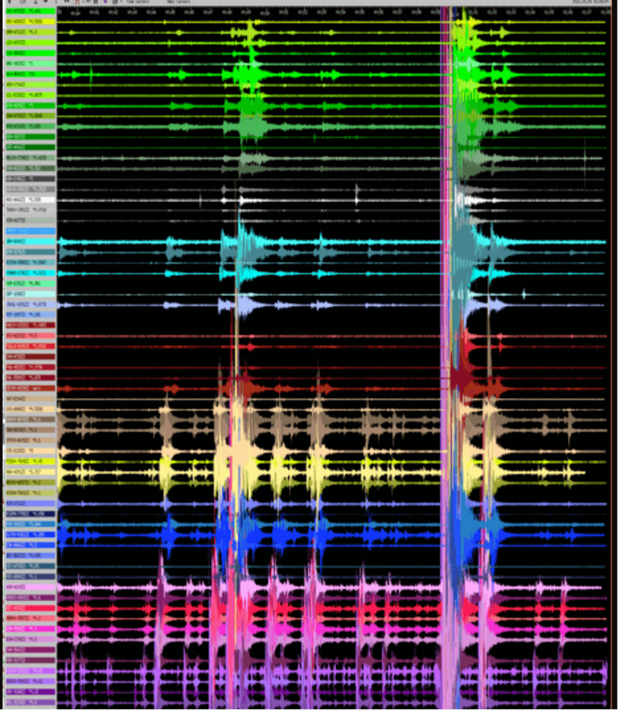
The image below shows an example from the monitoring stations in Iceland that detect these earthquakes. The signals are strong over the entire island, and the stronger seismic waves can be detected in most stations. It is interesting that the shape of these waves is also different, with a lot of earthquakes now showing signs of magma moving.
A VOLCANIC THREAT
Despite being tectonic in nature, earthquake swarms in Iceland do sometimes have a tendency to include magma. What starts as a simple tectonic swarm can turn into a volcanic eruption sometime later.
In strong swarms, the ground breaks and faults, creating fractures through which magma can rise to the surface. In most cases, the magma does not reach the surface as there is no available path and the earthquake swarm dies off before the magma gets that far.
More signals are emerging, that confirmed the involvement of magma below ground. The volcanic alert level was appropriately raised from yellow to orange for the region, by the officials. Notice the orange mark for the Krysuvik volcanic system.
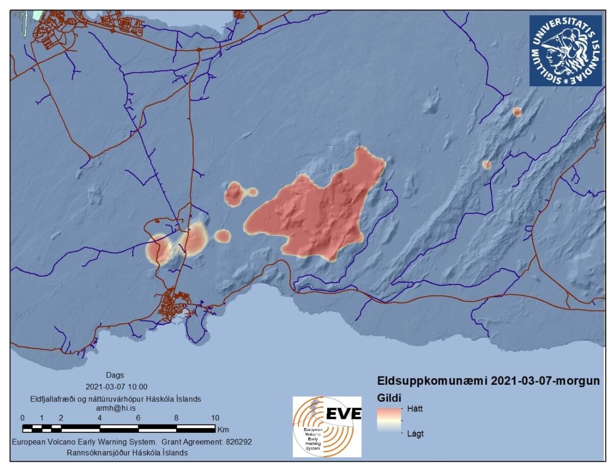
The official statement also confirmed that more evidence is being seen for magma rising beneath the surface in the earthquake swarm. one of the tools to see that, is the ground motion detection by satellites.
Below we have an image that shows vertical ground deformation. It shows where the ground has moved up (warm colors) or down (cold colors). We can see a large area or rising ground, likely associated with accumulating magma in that area.

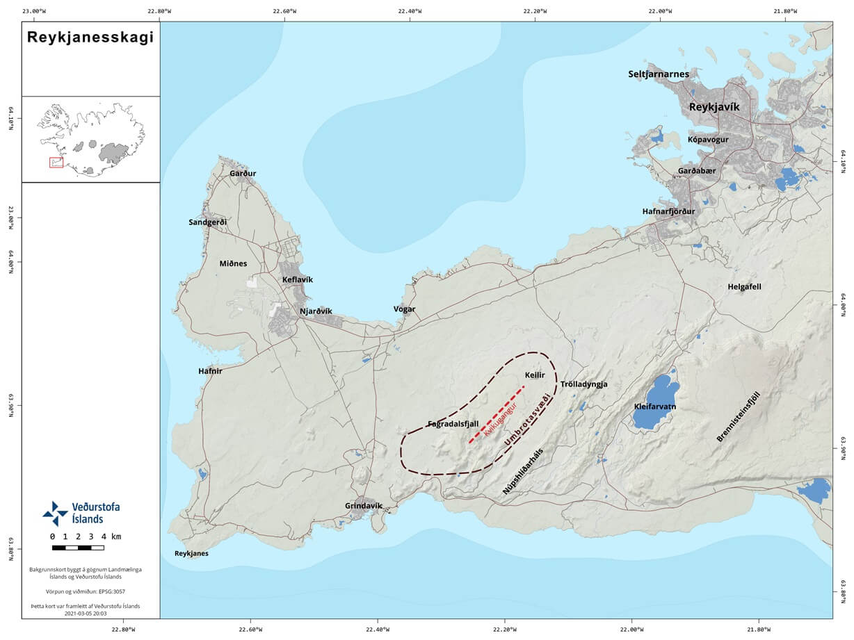
Based on all the earthquake data, a map was produced by the University of Iceland. It shows the highest risk of a volcanic eruption, which is in the Fagradalsfjall volcanic system. Note that there are some marked areas towards the west, but are not considered a likely eruption site for now.
The latest official report suggests that if an eruption occurs, it is most likely in the area between Fagradalsfjall and Keilir. This is also the area of the strongest earthquake magnitudes so far.
The next image shows the projected path that lava would take in a potential eruption from the area above. This is just a simulation, based on the current known information and historical data. Current calculations suggest an eruption of around 0.3 cubic kilometers of lava, which is not a particularly large eruption.
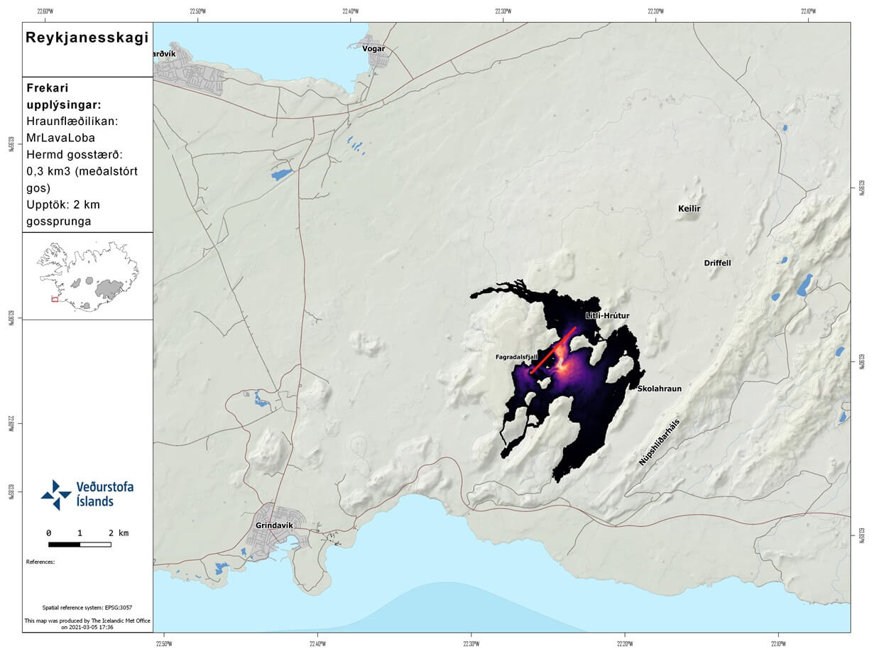
Such eruptions produce little to no ash, as the erupting lava is quite fresh. There is also no projected major interaction with water or ice in this region, so the eruption, if it happens, will be mainly in the effusive style, with lava flows. The projection on the image above is one of the more optimistic scenarios, as it poses little interaction/danger to the nearby population.
But these eruptions can produce a lot of sulfuric gas, which can be harmful if you inhale it in higher concentrations. We produced an image that shows the simulated air movement in the lower levels of the atmosphere. The starting point is on Wednesday, March 9th at 00UTC.
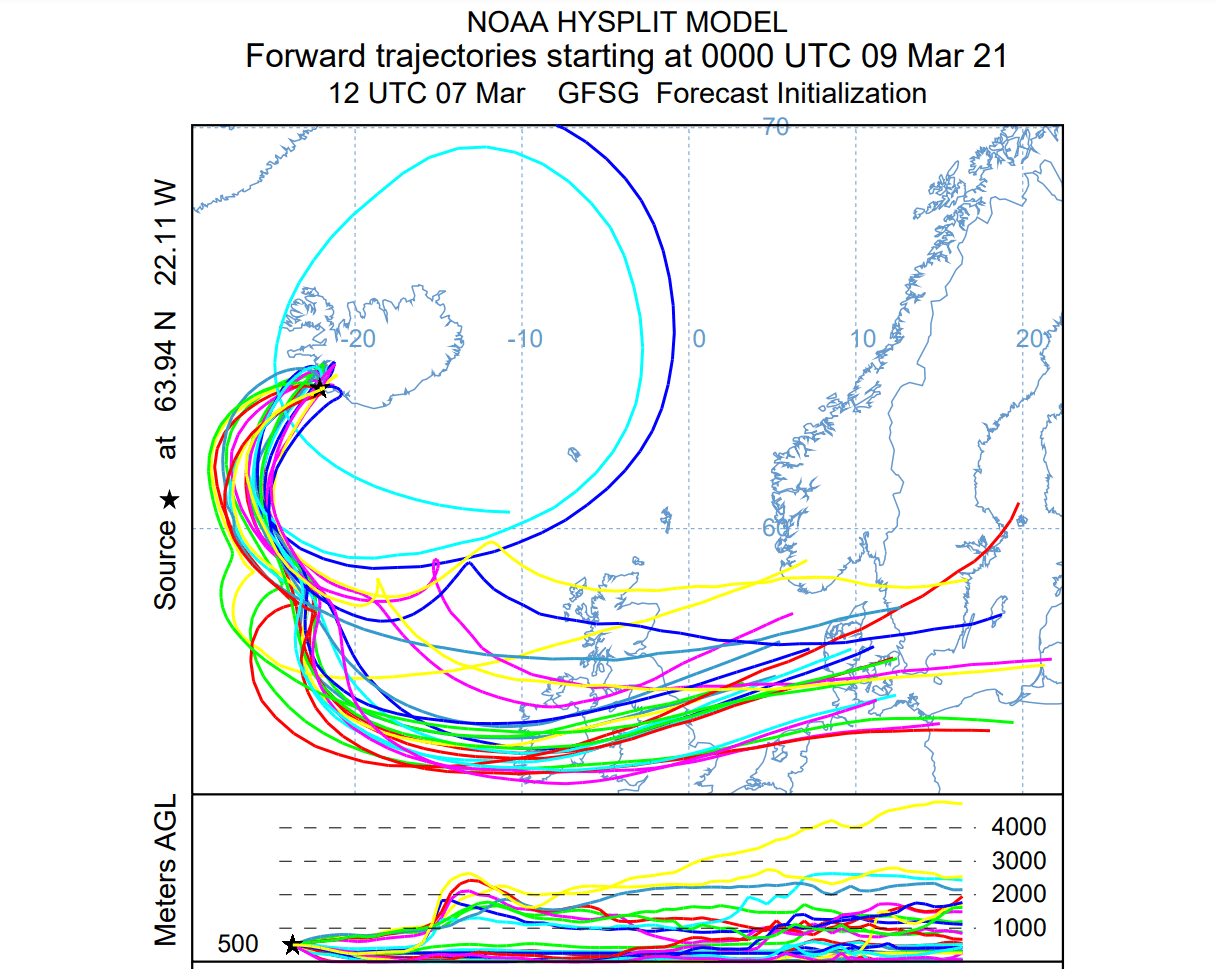
The image basically shows where the volcanic gases would be transported, if an eruption would start at that time. We can see the airflow takes the particles towards northwestern Europe, over the British isles. It then continues towards the east, over north-central Europe and southern Scandinavia.
But this does not mean that volcanic gases would actually reach these regions. Based on the currently expected eruption strength, the concentration of the gases should not be significant outside of Iceland.
It would take a strong eruption to produce enough gas to reach Europe in harmful concentration. It has happened in the past, with deadly consequences, and it can happen again in the future.
But if an eruption does happen, it is not currently projected to produce such strong concentrations of volcanic gases.
There is also a possibility that the earthquake activity could slowly reduce, ending with no eruption.
The official agency in Iceland for monitoring volcanoes is the Icelandic Meteorological Office (IMO), where you can find live data, additional information, and all official warnings.
We will keep you updated as fresh data is available, and more reliable projections can be made.
CHECK out our first article of this earthquake swarm series, which contains more info on Reykjanes Peninsula and its volcanic history:
A powerful earthquake swarm begins on Reykjanes Peninsula, Iceland
Also don’t miss:
A pattern change could bring severe weather to the UnitedStates: