The remnants of Hurricane Epsilon have been racing across the North Atlantic today after a textbook extratropical transition this morning. Now, the remnants are merging with the explosively developing low, located south of Iceland. A very powerful extratropical storm is unfolding and will release a massive windstorm and major waves towards western Europe over the next few days.
While the hurricane Epsilon was battling a strong shear overnight, it has finally begun an impressive extratropical transition today and has now been absorbed into a larger, developing extratropical storm. A very explosive development and deepening of the central pressure is now expected to continue overnight.
If the North Atlantic’s post-tropical (extratropical) origin comes from a well-organized tropical system – in this case, it was a major hurricane Epsilon last week – the strength of the extratropical storm could be much more violent than normal Atlantic storms.
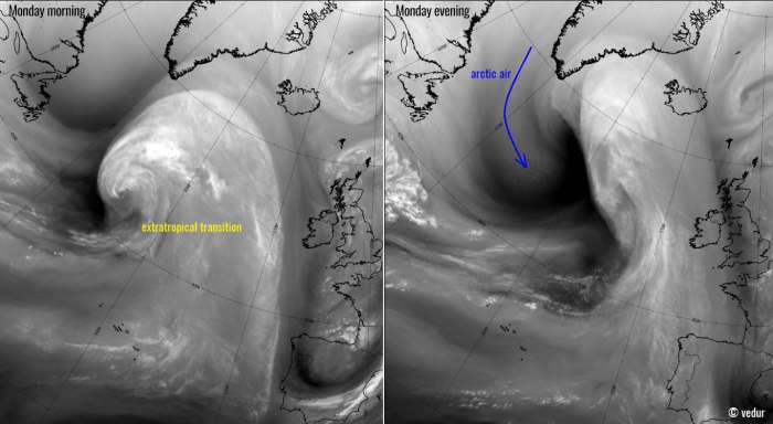
This is Monday’s morning view of the North Atlantic in visible satellite channel. The hurricane has been downgraded into a Tropical Storm Epsilon and begin its extratropical transition. There was an impressive cloud pattern spread to the north of the Epsilon’s center.
The final system will become a very large North Atlantic depression with very deep minimum central pressure in its core on Tuesday. It may peak at around 940 mbar on Tuesday. The broad channel of violent winds will develop a massive windstorm and significant waves spreading towards Ireland and the UK.
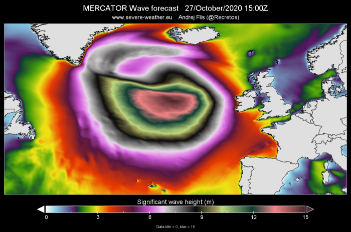
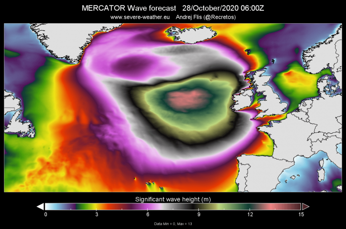
Attached is the animation of the significant wave heights developing with this explosive North Atlantic extratropical storm. Major waves should reach 12-13 meters (40-42 feet) to the south of the low’s center on Tuesday and gradually push towards Ireland, Northern Ireland, and Scotland on Wednesday morning.
SPECTACULAR SATELLITE PRESENTATION OF MERGING LOWS
The satellite presentation over the North Atlantic today revealed a very impressive and textbook transition of hurricane Epsilon into an extratropical low. Attached are water vapor satellite images of Monday morning versus Monday evening. We can see there is now a massive Arctic air mass advection in the wake of the merging systems.
This will help to boost the intensification process of the storm.
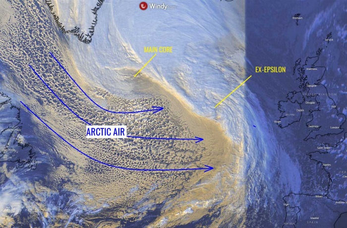
Below is a close-up view of both systems merging this afternoon (Monday). We can see a broad channel of Arctic air mass advection from the Labrador Sea (between Greenland and eastern Canada) into the North Atlantic, in the wake of the strengthening large depression.
The main core of the broad circulation is seen to the south of Greenland southern tip, while the remnants of ex-hurricane Epsilon are visible to its southeast. Approximately halfway between the main core and Ireland. The cold maritime air mass is well visible with a broken cloud pattern and scattered showers moving into the depression.
The remnants of Epsilon will curve around the main core tonight and add an extra boost to its rapid intensification process. Explosive development is expected.
HURRICANE EPSILON TRANSITION INTO EXTRATROPICAL STORM
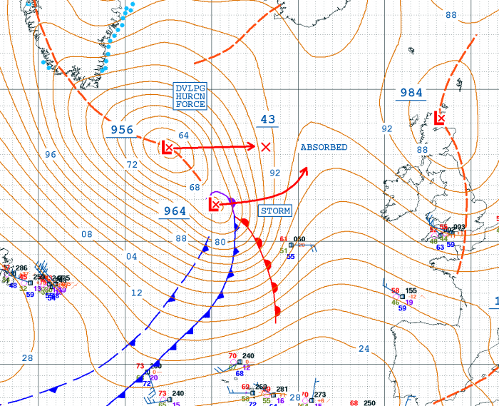
Based on the North Atlantic today’s NOAA OPC 12 UTC (Oct 26th) analysis, the extratropical transition of ex-hurricane Epsilon is fully completed. Below is a detailed pressure analysis of hurricane Epsilon transition into an extratropical storm over the past 24 hours:
964 mbar at 12 UTC, Oct 26th (fully extratropical storm)
969 mbar at 06 UTC, Oct 26th (extratropical storm transition)
968 mbar at 00 UTC, Oct 26th (tropical storm)
963 mbar at 18 UTC, Oct 25th (hurricane)
960 mbar at 12 UTC, Oct 25th (hurricane)
The main deep core of the North Atlantic depression, which is located to the immediate north of the secondary low, has been explosively developing at the same time as well.
Here are details for the main core of the broad North Atlantic circulation:
956 mbar at 12 UTC, Oct 26th
972 mbar at 06 UTC, Oct 26th
984 mbar at 00 UTC, Oct 26th
980 mbar at 18 UTC, Oct 25th
982 mbar at 12 UTC, Oct 25th
The central surface pressure of this core has deepened from 982 mbar to 956 mbar since Sunday 12 UTC. That is a 26 mbar pressure drop during the past 24 hours which is well beyond the threshold for explosive cyclogenesis / rapid intensification.
The threshold is a 24 mbar pressure drop in the past 24 hours period.
Both cores, the ex-Epsilon and the main core will merge on Tuesday morning.
EXPLOSIVE DEVELOPMENT OF THE STORM
The rapid intensification process is still underway and additional, rather explosive development is expected through Monday’s night into Tuesday. The central pressure will deepen for another 20-25 mbar. Therefore, another 24 hours period of explosive intensification is forecast and the final system will push the central pressure much lower than today.
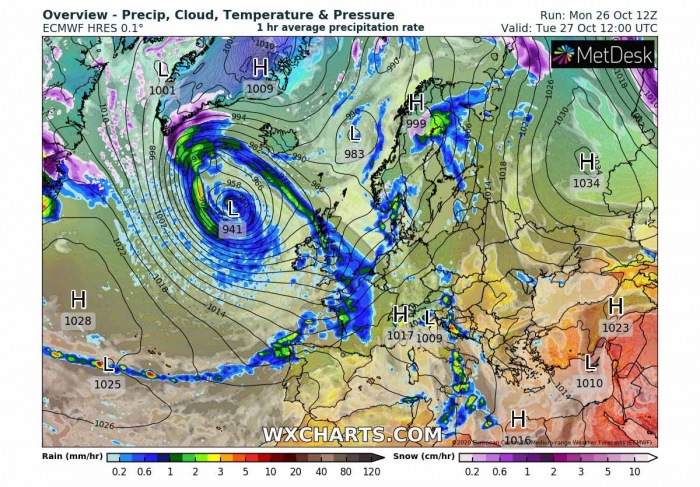
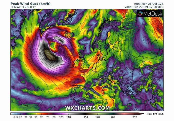
By early afternoon on Tuesday (12 UTC), the central pressure is forecast to reach near 940 mbar. A very violent windstorm will develop to the immediate south-southwest of the cyclone’s core.
This can be seen from the attached pressure forecast below, where isobars are very tight within the broad channel of arctic air mass wrapping towards the core.
The pressure difference between the cyclone’s core and the center of the Azores high will be almost 90 mbar!
The resulted violent wind field will be the strongest far away from the European land, however. But will be violent. The low is expected to peak at this time and begin its occluding phase while the core slowly drifts towards the northeast.
At the same time and much further west, a new upper short-wave ejects from eastern Canada into northwestern Atlantic and accelerates towards the North Atlantic. An associated surface low will develop as well, moving east within the powerful jet stream rounding the base of the main extratropical depression.
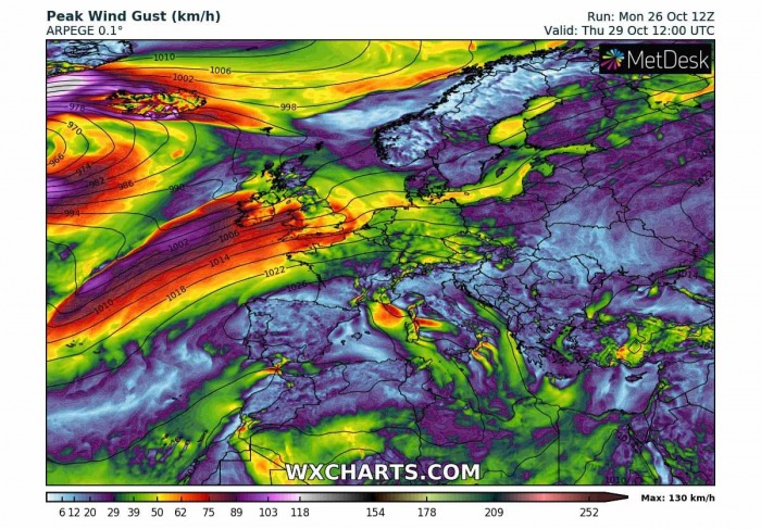
The new wave and surface low will approach western Europe by Thursday morning. It will bring another frontal system into Ireland and the UK, with mainly some more excessive and heavy rain besides the gusty winds. Some winds could be severe, especially across western Ireland.
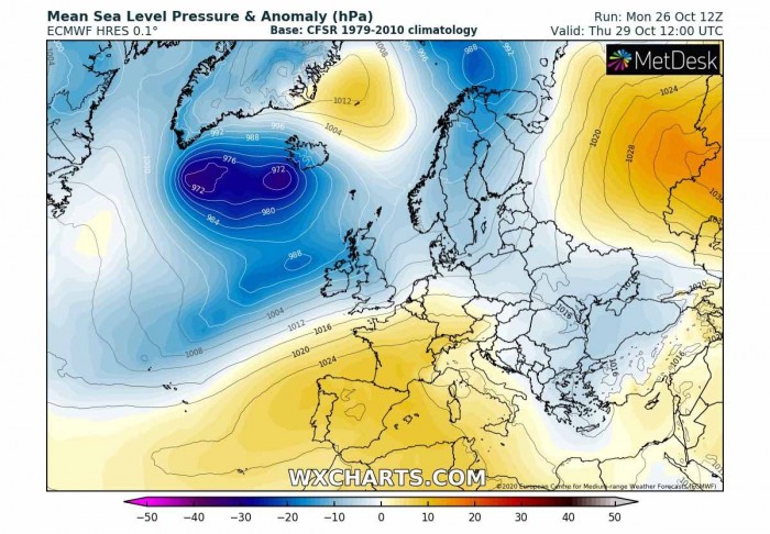
The main North Atlantic storm will continue gradually weakening through Wednesday and Thursday while its core will move closer to Iceland. Severe winds are expected to develop across the northern and western portions of the storm. As the pressure gradient strengthens against the surface high-pressure system over Greenland.
Severe to locally extremely severe winds are possible across southwest Iceland where hurricane-force downslope winds could develop from the glaciers.
VIOLENT WINDS WILL DEVELOP OVER THE NORTH ATLANTIC
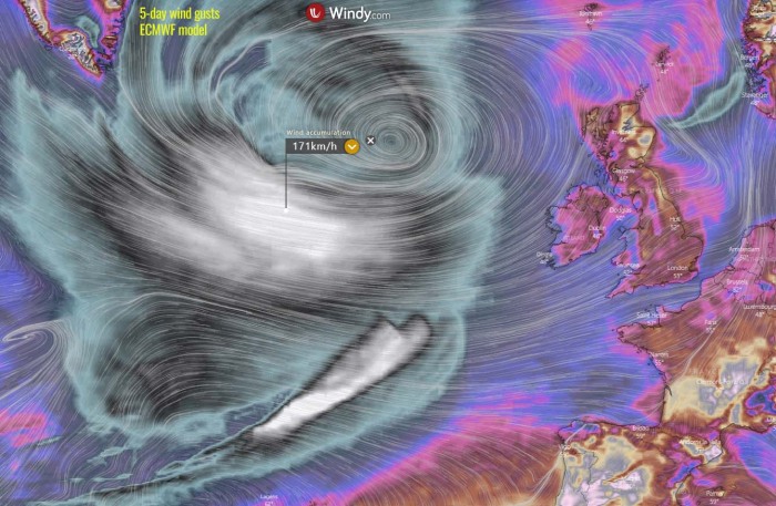
Looking over the accumulated wind gusts over the next 5 days we can see a very large area affected by violent, even hurricane-force winds with the first, main North Atlantic extratropical storm.
The next wave, scheduled to arrive on Thursday will bring a more narrow swath of intense winds, but will also be quite violent. As models are currently indicating, those will be the strongest prior to their arrival to western Europe as the wave begins widening later on.
Although the pressure gradient around the deep North Atlantic storm will be lead to broad hurricane-force 130-150 km/h wind gusts, there are also additional possibilities that a sting jet* could be developed near the core of the cyclone. If it occurs, violent winds in excess of 160 km/h are very likely to develop.
*A sting jet is a relatively localized jet of rapidly descending cold air inside a deep extratropical cyclone. It affects a small region, compared to th size of the cyclone, and lasts only several hours. Destructive winds of over 150 km/h have been attributed to sting jets.
Read more: What is a sting jet?
The most intense winds will, however, stay further west of western Europe. That is mainly due to the Azores high expanding into western Europe, so the steering flow pushes the depression’s core rather further north-northeast than east. So the main wind field will not advance eastward that much.
But what will be the main result from these broad violent winds, are major waves developing across the southern portions of the storm where the pressure gradient is maximized.
MAJOR 40+ feet (12+ meter) WAVES FOR IRELAND
Significant wave heights are expected to develop due to the explosive nature of this North Atlantic extratropical storm. The storm’s broad violent wind field will result in major waves that should reach 13-14 meters (42-45 feet) to the south of the low’s center on Tuesday.
These major waves will be gradually moving towards Ireland and the UK on Wednesday morning and affect the coastal areas. The highest waves could reach 9-12 meters (30-38 feet) along with the coastal areas of western Ireland, western Northern Ireland, and western Scotland.
High waves will also gradually spread towards the Faroe Islands as the core of the extratropical storm will be traveling towards the northeast over the next 24-36 hours. The southern fringe of the broad area of significant wave heights will also reach southwestern England and the Bay of Biscay.
HEAVY RAIN ACROSS IRELAND AND WALES
Although the first large North Atlantic depression will not bring a significant amount of rainfall into western Europe, the next wave coming on Thursday will bring new rainfall across the British Isles.
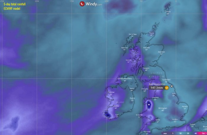
Attached is the 5-day rainfall total per the ECMWF global model which hints at around 120-150 mm of rain possible across the higher terrain of Wales where the orographic features of the persistent southwesterly flow will be the highest. Quite a lot of rain will also accumulate in southwestern Ireland.
DON’T MISS:

