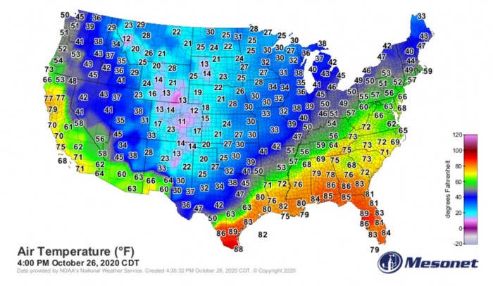
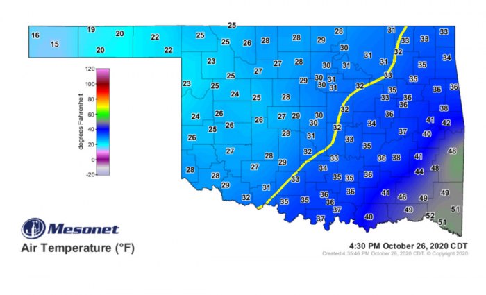
The extremely cold, and record-breaking Arctic cold outbreak shattered numerous records across the nation, from Montana and Dakotas across the Great Plains down to Texas. A significant amount of snow has developed over the Rockies. But now, the main focus is a major icestorm with potentially catastrophic widespread tree damage and power outages forecast across Oklahoma and Texas over the next 36 hours.
The Arctic cold outbreak that was forecast to spread down across the Great Plains and Midwest on Sunday and Monday has brought very cold weather as far south as central Texas. Temperatures have slid below zero across the western half of Oklahoma, whole Panhandles, and part of west-northwest Texas.
Some snow has occurred, while also freezing rain developed across parts of Oklahoma on Monday.
While areas across New Mexico, the Panhandles and Kansas are seeing and should receive some reasonable amount of snow, the biggest concern is now definitely potentially very significant impacts of freezing rain* with a major icestorm forecast for parts of Texas and Oklahoma from Monday night through Tuesday.
Icestorms and freezing rain (black ice) are extremely dangerous and damaging during the winter months, but right now it is still only October and most of the trees still have their leaves.
Numerous residential structures could lose electricity for days. To keep in mind that the power lines could break under the weight of the ice alone, even without overhead tree branches crashing down.
What is freezing rain?
The freezing rain forms when a layer of warm air aloft is placed above a layer of below-freezing (subfreezing) air at the surface. Snowflakes that falling towards the ground, melt as they fall through this warm layer. If the flakes are completely melted, then it is falling as rain towards the ground which is much colder. This liquid droplet then freeze on contact with exposed surfaces
WIDESPREAD, CATASTROPHIC ICESTORM LIKELY
The second round of wintry precipitation will begin across the western portions of Texas and Oklahoma late Monday and intensifying through Monday night into Tuesday. They will also increase coverage.
The greatest snow and ice accumulations in this icestorm event are expected on Tuesday afternoon before temperatures are forecast to finally warm up again and precipitation type will likely change back to rain.
Temperatures across Oklahoma have drifted strongly below freezing. The Arctic cold front has brought the 0 °C (32 °F) line across central Oklahoma by Monday early afternoon. Temperatures are even lower, low to mid-20s across western Oklahoma and the Panhandles.
But this would be nothing to concerning yet if we wouldn’t have a look over the vertical temperature profiles in the region. The attached Skew-T (sounding temperature vertical cross-section diagram) for Norman, Oklahoma City (central Oklahoma) indicates that there is a massive deep warm layer placed above the much colder near-surface layers.
Analysis through the layers at 18 UTC on Monday, Oct 26th, reveals that there are temperatures several degrees below freezing across the lowest 1200 m above the ground. But then, much warmer temperatures are seen across the layer from 1200 to 3800 meters (approx. 4000 to 12500 feet) above the ground.
Therefore, the temperatures at the height or around 2000 meters above the ground are close to 5 °C (approx. 41 °F). So very warm, compared to around -2 °C (28 °F) at the ground. Strong thermal inversion is present and the forecasted precipitation will support heavy freezing rain. Notice there is also strong southwesterly wind aloft, helping to transport high moisture into the region.
Also, keep in mind that it is even colder further west of Oklahoma City and across the southwest parts of the state. So the temperature difference between mid-levels and the surface is even greater.
The event is likely to lead to widespread catastrophic tree damage from northwest Texas into west-southwest and central Oklahoma on Tuesday.
It is quite likely that such an amount of ice would cause power line destruction with numerous power outages as tree branches to come crashing down. The weight of ice accumulating will be significant with this icestorm, especially on trees that still have leaves.
Attached is the weather forecast for the total amount of freezing rain by Pivotalweather model HRRR. What we see here is actually beyond exceptional and extreme.
A broad corridor across northwest Texas and west, southwest, and central Oklahoma could see between 1 and 1.5″ (2.5-4 cm) of freezing rain (black ice*) accumulation.
If this verifies, the event will not be just historic for October this far south, but also deadly and destructive.
*black ice – is ice that has developed (accumulated) on the surface of a roadway. It is transparent but takes on the color of the surface of the road it is on. When ice gets wet from the outside temperatures warming up, it becomes dangerously slick and it has lead to numerous deadly road accidents across the world.
The ICESTORM WARNINGS are in effect (dark purple) across parts of Oklahoma and northwest Texas. 3/4″ of ice may accumulate in some spots, maybe, even more, depending on the convective nature of the precip.
The latest high-resolution model guidance is hitting an extreme amount of ice accumulation is now very likely to occur. The event is strongly depending on the convective nature of the precip, as some sleet could also occur at times.
While the first icestorm round is almost over central Oklahoma this Monday afternoon, there are reports of around 0.25″ (0.6 cm) of black ice accumulation in some places.
Another, much more significant round of freezing precipitation will develop tonight and on Tuesday. Another upper-level disturbance (wave) begins to rotate around a cut-off low developing in the southwest United States.
As even colder temperatures will be present and the ground is cooling further with lower temperatures, the ice should accumulate even faster and result in a significant thickness rather quickly.
The National Weather Service (NWS) in Norman, Oklahoma has a concerning warning in effect – close to 1″ (2.5 cm) or even more, ice could accumulate by Wednesday morning.
“Some significant ice accumulation will occur today, Tuesday, and even early Wednesday that may lead to power outages and widespread tree damage. There is still some uncertainty on ice amounts, but the highest totals will be mainly seen west of Oklahoma City. Ice accumulations approaching 1/4″, with some totals closer to 1″, can be expected. In addition, sleet accumulations are possible. Some snow accumulations of an inch or two appear possible across northwest Oklahoma.”
The snowy and icy conditions will lead to significant travel hazards across the region. Be extremely cautious about the rapidly worsening conditions tonight and through Tuesday (tomorrow).
This icestorm event could be destructive and deadly!
-29 °F in POTOMAC, MONTANA – RECORD LOW TEMPERATURE FOR THE LOWER-48
The National Weather Service (NWS) in Missoula, Montana has tweeted on Sunday evening:
“The -29°F (-33.9 °C) in Potomac, Montana will become the lowest temperature measured at an official climate site anywhere in the contiguous (lower 48) United States so early in the season in ANY YEAR!”
Yes, you have read that right. History has been written today. The all-time record of the lowest temperature ever measured in October – the earliest extremely cold temperature on record.
The previous record low by Oct 25th was -20 °F (-28.9 °C) in Bowen, Montana in 1919. There was another unofficial report of -31 °F in Wyoming.
There was also another extremely cold morning across Montana on Monday. Here are some of the recorded daily low temperatures for Oct 26th:
-21 °F (-29.4 °C) – Potomac, MT
-18 °F (-27.8 °C) – Butte, MT (previous record 9 °F in 2002)
-17 °F (-27.2 °C) – Elliston, MT
-15 °F (-26.1 °C) – Deer Lodge, MT
-14 °F (-25.6 °C) – Hot Springs, MT
-5° F (-29.1 °C) – Missoula, MT (previous record 13 °F in 1919)
0° F (-17.8 °C) – Kalispell, MT (previous record 10 °F in 2002)
Record low temperatures for late October were expected, as the cold outbreak was expected to be very intense. While the recorded lows were then much more significant than forecasted by various weather models.
LATEST SNOW AND TEMPERATURE FORECAST
A swath of impressive, high snowfall accumulation is likely to develop across northern New Mexico. Close to 15 inches (40 cm) is forecast by the latest ECMWF model. The weather model is also hinting that around 10 inches (25 cm) of snow will be possible over Texas Panhandle until Wednesday morning.
Much less snow is forecasted further south into West Texas and also across Kansas and Oklahoma, mainly due to much more precipitation falling as a freezing rain discussed above.
Tuesday will also bring the final very significant cold morning. Near freezing temperatures will spread from northern Illinois across central Missouri, eastern Oklahoma into south-central Texas. It will be much colder northward and indeed much warmer toward the south.
Aside note: The most extreme low temperatures are often recorded within cold pools in small localized, closed valleys and flatlands. Such locations could push temperature even lower. Those are called sinkholes.
The sinkhole is an area where very cold air is trapped and extremely low temperatures can occur. During calm cloudless nights, these often high elevation basin dissipates daytime heat rapidly into the atmosphere. Cool, much denser air then slides downwards towards the basin floor in a process known as cold air pooling. Consequently, very low temperatures result.
The most known sinkhole is Peter Sinks. A natural sinkhole in northern Utah that is one of the coldest places in the contiguous United States. On Feb 1st, 1985, a record low temperature of −69.3 °F (−56.3 °C) was recorded there.
This was the lowest recorded temperature in Utah, and the second-coldest temperature ever recorded in the contiguous United States.
DON’T MISS:
Here is the latest update on a re-developing Zeta tonight:


