Spring 2021 weather season is upon us. After a very dynamic winter, what weather can we now expect? Latest spring forecasts call for dominant high-pressure systems in the Pacific and the Atlantic, with adverse weather influence in North America and Europe.
The Meteorological Spring season covers 3 months, March-April-May. An important influencer for the spring season this year will be the colder than normal tropical Pacific Ocean.
ROLE OF THE OCEANS
To keep it simple, there is a region in the tropical Pacific ocean, which alternates between cold and warm phases. The tropical trade winds (winds that circle the Earth near the equator) usually initiate or stop a certain phase, as they mix the ocean surface waters and alter the ocean currents.
Below we have an image that shows the current ocean temperature anomaly. It reveals where ocean temperatures are warmer/colder than normal. The region of colder than normal waters in the Tropical Pacific is called the ENSO region, which is currently in the negative (cold) phase.
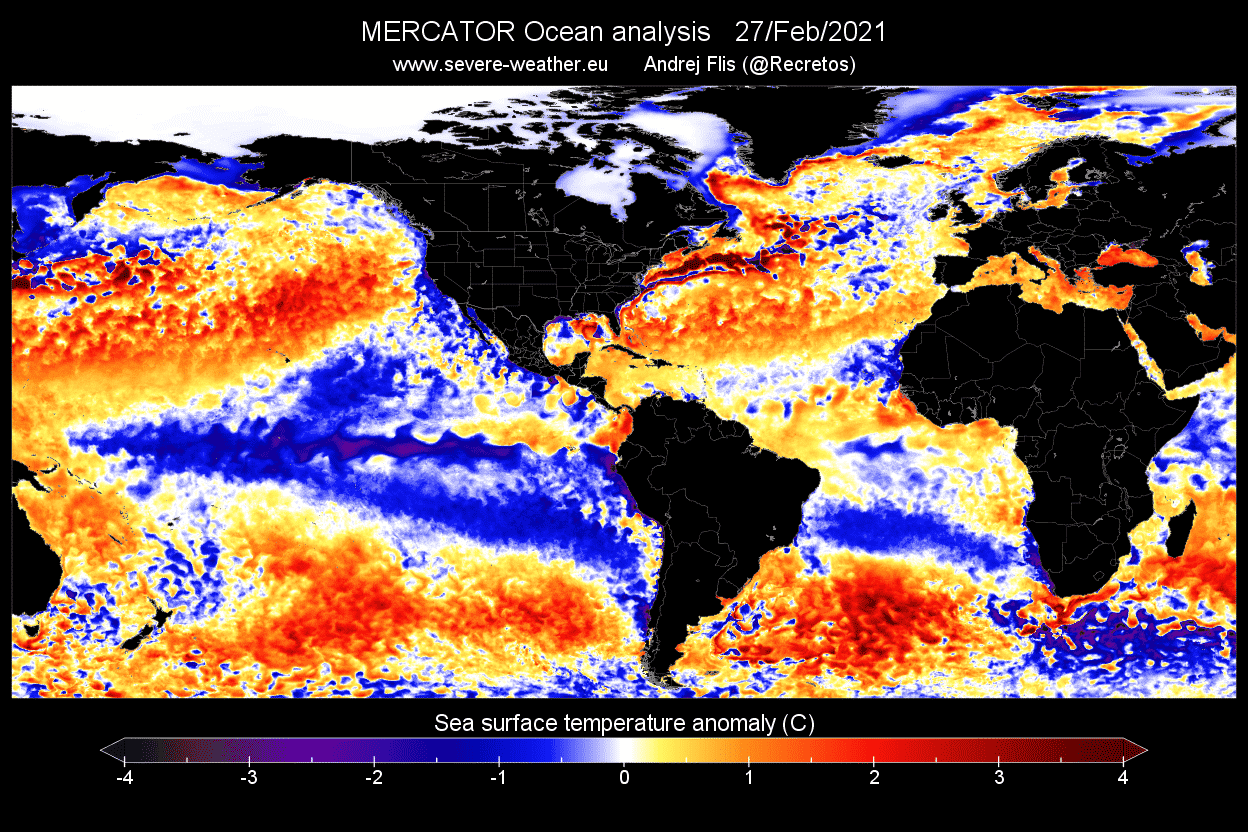
The cold phase is called La Nina, while the warm phase has a more famous name, the El Nino. Each ENSO phase has a different influence on the tropical weather and thus impacting the weather worldwide differently.
A specific phase (warm/cold) usually develops around late summer and autumn and can last until the next spring, or even up to two years in some cases.
We produced a high-resolution animation, which shows the ocean temperature anomalies across the tropical Pacific ocean. You can nicely observe the cold phase at its peak strength in November and December 2020. Take note of how the colder waters are being pushed from east to west by the strong trade winds in the tropical Pacific region.
The image below from NOAA Climate shows the typical circulation during a cold ENSO phase. Air descends in the eastern Pacific, causing stable and dry weather, while air rises in the western Pacific, causing frequent thunderstorms and a lot of rainfall.

This way, ENSO has a major impact on tropical rainfall and pressure patterns. From here, this disturbance influences the subtropical regions, spreading its influence on the global weather patterns.
Preliminary data shows that the cold phase has already reached its peak in late 2020. While it was not the strongest of all time, this cold phase was indeed quite strong. This increases the likelihood of its impact reaching into spring 2021.

One of the main influences of the cold ENSO phase (or any other phase) can be seen in the changing jet stream. For the cold phase, the most common signal is a strong high-pressure system in the North Pacific ocean.
You can see the usual jet stream position during the cold ENSO seasons and the corresponding weather development over North America. The twisting jet stream brings colder air and storms down from Canada into northern and the northwestern United States, and warmer and drier weather to the southern parts.

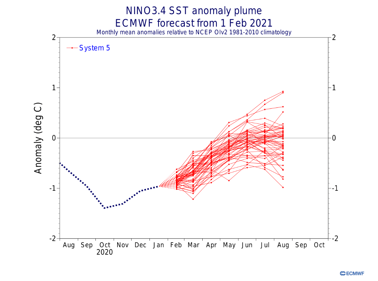
Below we have an analysis/forecast graphic by ECMWF, which shows the ocean temperature evolution of the ENSO region. The cold phase is already past its coldest point and is currently expected to go into a neutral phase in spring. Despite the weakening cold phase, its influence can sometimes still be present for weeks/months after its demise.
The official probabilistic forecast from IRI, also shows the cold phase persisting into spring. But a neutral state looks to be dominant as we go further towards Summer 2021.

SPRING 2021 MODEL FORECAST
For the spring 2021 forecast, we decided to focus on the 3 main (or most used) seasonal models. The ECMWF and UKMO from Europe, and the CFSv2 from the United States. Graphics are from the Copernicus Climate EU project and the CPC/NCEP.
All these forecasts show an average picture over the course of 3 months (March-April-May) and reveal the general prevailing weather pattern forecast. This does not mean that such weather conditions would last for 3 months straight. It only shows/implies how the weather patterns might look 40-60% of the time.
ECMWF FORECAST
Starting off below is the ECMWF global pressure anomaly forecast for Spring 2021. Right away, we can see the signature high-pressure system in the North Pacific. We also have a clearly defined low-pressure system over western Canada. Both are well-known signs of the direct cold ENSO phase influence.
There is also a high-pressure zone over the North Atlantic. Positive anomalies extend towards the east into Europe. But in reality, a strong high-pressure anomaly over the North Atlantic in most cases calls for lower pressure over Europe instead.

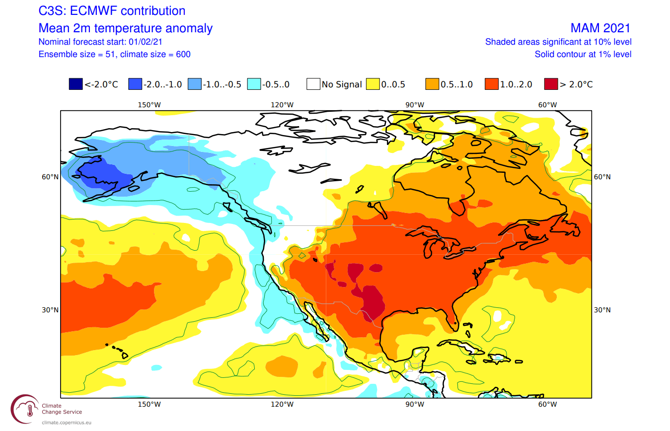
We usually look at the temperature anomalies at 850mb level (1.500m/4.900ft alt.) to estimate the airmass distributions. Over Europe, airmass anomalies are mostly normal to slightly warmer than normal towards the eastern regions.

Most of the United States is under a warmer than normal airmass, as is eastern Canada. This is a result of the lower pressure over western Canada, which promotes warmer southerly flow into central and eastern United States and eastern Canada. At the same time, the low-pressure area over western Canada pulls down colder air from the north, cooling down Alaska and western Canada.
Looking closer at temperatures in Europe below, we see an interesting progression from west to east. It is evident that cooler airmass from the Atlantic will be present for western Europe. This does mean that occasional pattern progression can allow colder spring air in from the north/northwest into western and parts of central Europe. Further east, warmer conditions prevail. This setup is dangerous for spring cold fronts and frost events in western and central Europe.

Over North America, we see quite a warmer than normal pattern dominating. Colder than normal conditions prevail over western Canada and Alaska. Due to the jet stream position from the northwest, the colder temperatures extend further towards the northwestern and northern United States. We can see mostly above-normal temperatures over the continental United States and the into eastern Canada. That is mostly due to the prevalent warmer southerly flow.
The precipitation anomaly forecast below shows a typical cold ENSO type pattern over Canada and the United States. Northern parts are under wetter conditions, while drier conditions prevail in the southern United States. We can see a neutral “gap” in the drier part of the southern/central United States, which covers the tornado alley. Combined with above-normal temperatures, it can indicate more convective activity (storms) in spring, which we will cover further down in the article.

Europe is quite neutral when it comes to precipitation. This shows higher pattern diversity is likely, especially on a month-to-month basis. No strong drought trends are visible, with some hints of above-average rainfall towards northern Europe. Western Europe is under drier than normal conditions, likely influenced by the dominant high-pressure system in the North Atlantic, forcing a drier northerly/northwestern flow.
UKMO FORECAST
In the UKMO model forecast, we can also see the signature high-pressure system in the North Pacific. We also have the clearly defined low-pressure system over western Canada, a sure sign of the direct cold ENSO phase influence, as we mentioned before.
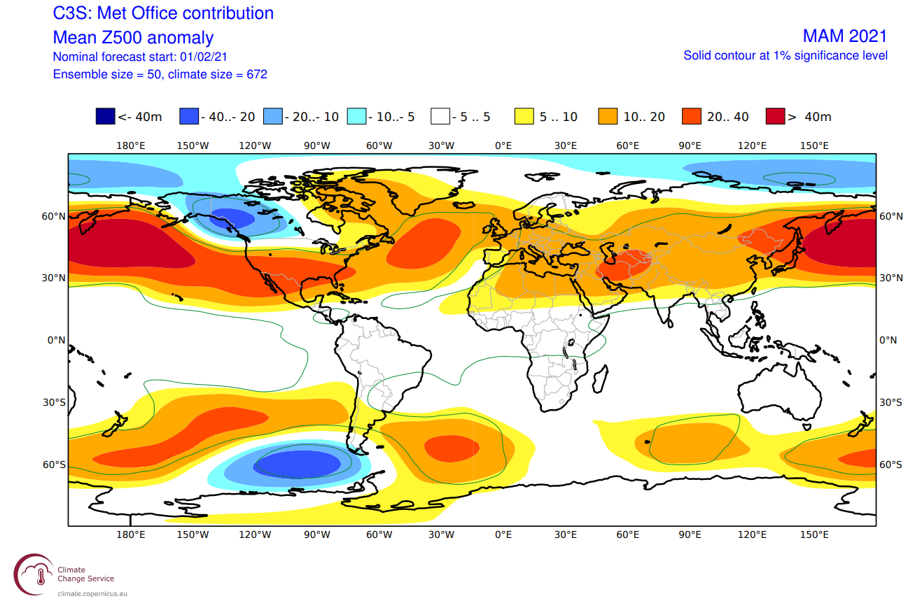
There is also the same high-pressure zone over the North Atlantic, as in the ECMWF. But in this UKMO forecast, we can see it extends a bit further towards the north. This forecast also indicates a possibility of a low-pressure zone in southwestern Europe, a likely cutoff-low (rex block) situation under the blocking high.
Moving over to the airmass temperatures, we have mostly above normal temperatures over Europe, with a normal/neutral zone over southwestern Europe.
Most of the United States and far eastern Canada is seen warmer than normal. We do have a quite strong pool of colder than normal airmass over Alaska and western Canada. This is a direct result of the northerly flow there, from the low-pressure system sitting over western Canada.

Looking at surface temperatures in Europe below, we see a similar progression from west to east as in the ECMWF. It is evident that cooler airmass from the Atlantic will be present for western Europe. With the high-pressure system in the North Atlantic, some northerly airflow can also be expected over northwestern Europe. This can send cold fronts far into central Europe.

Over North America, we see quite a warmer than normal pattern dominating, just like in the ECMWF forecast. A large area of colder temperatures remains over western Canada and Alaska, extending towards the northwestern and northern United States. We can see mostly above-normal temperatures over the continental United States and the into eastern Canada, due to the prevalent warmer southerly flow.

The precipitation forecast shows the northern United States and eastern Canada under wetter conditions, while drier conditions prevail in the southern United States. This is a similar forecast to the ECMWF, but here we can see much drier conditions in the southern United States.

Europe has a completely neutral precipitation anomaly, indicating a normal spring precipitation-wise. No drought trends are visible, with some hints of above-average rainfall towards northern Europe.
CFS FORECAST
As a counterbalance to the Euro models, we mainly use the CFSv2 (Climate Forecast System) model from the NOAA/NCEP in the United States.
The CFS model is in essence very similar to the two Euro models. We have a higher pressure system in the North Pacific and a low-pressure area over western Canada. What is different in this model, is the western Canada region, which lacks a well-defined low-pressure system.

We can also see high pressure/ridge over the North Atlantic extending into northwestern Europe. This ridge is important for the Euro-Atlantic sector as it can sustain a more northerly flow over western and central Europe. Such a situation increases the frost risk in mid and late Spring in central Europe.
The temperature forecast for Europe does show the same picture as the previous models, with the warmth increasing towards the northeast. Western Europe is more neutral with temperatures. That is mainly because of the cooler Atlantic airmass and the potential for some more northerly flow in individual situations involving the northward-extended Atlantic ridging.

For North America, this spring temperature forecast is probably the warmest of all the models. It shows a slightly colder air anomaly over Alaska and western Canada, into the northwestern United States. But there is much less cold air available than in the previous two forecasts. This is likely related to the absence of a stronger low-pressure system over western Canada.

The precipitation anomaly forecast shows a quasi-dipole pattern over North America, with wetter conditions towards the east and the northwestern United States and drier in the south/southwest. We can also see a hint at above-normal precipitation in the central United States, possibly hinting at a more active severe weather season.

Europe is generally neutral in the eastern regions, with a higher chance of above-normal spring precipitation is over northwestern Europe. But western Europe shows a much drier trend, due to the high-pressure system sitting over northwestern Europe.
LA NINA AND SPRING TORNADOES
As history shows, the cold ocean waters in the tropical Pacific can also have a profound influence on the Spring tornado season in the United States. And not in a good way.
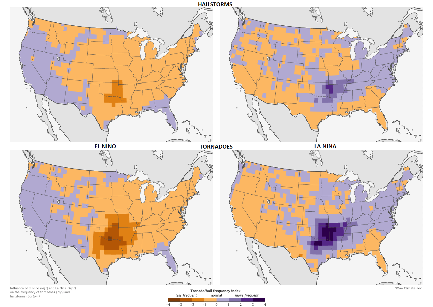
We have a very interesting image below from NOAA Climate. It shows a very nice comparison of hailstorm and tornado frequency during the spring season in the United States, between El Nino and La Nina years (warm and cold ENSO phases respectfully).
It is quite interesting to see, that in a cold ENSO spring season, there is a substantially higher frequency of hailstorms and especially tornadoes in the southern and southeastern parts of the United States. This severe weather pattern very profoundly outlines the central and eastern parts of the Tornado Alley.
Tornado Alley is a nickname given to an area in the southern plains of the central United States that consistently experiences a high frequency of tornadoes and other severe weather each year.
Below is a graph which shows annual tornado numbers in the United States from 1954 to 2014. Looking at the years, we can see that from the top 5 most active tornado years, 4 were cold ENSO years. At least for the spring tornado season, which is also the most active part of the year for tornadoes.

Looking only one month ahead into March 2021, the precipitation anomaly forecast from the CFS shows the increased precipitation area in the exact same area. This is a strong indicator of an increased severe-weather threat.

The temperature probability forecast also confirms the increased severe-weather threat. Having more precipitation together with higher temperatures, usually indicates the rainfall is more in the form of storms and showers. With the specific jet stream position over North America, any large-scale convective weather development can be quite severe.

SPRING 2021 SUMMARY
Reading images and descriptions can be somewhat confusing. So to summarize, here is what the models suggest for the Spring season 2021:
Europe is expected to have warmer than average temperatures over most of the central and eastern regions of the continent. This, however, does not mean that there will be no cold fronts and colder spring days. It just implies that cold fronts and colder air mass intrusions will be less frequent over the continent.
The exception is western and west-central Europe. There, some cooler North Atlantic airmass and occasional colder air transports from the north can be expected. Mainly due to the high-pressure system being dominant in the North Atlantic. This raises the concern for frost events over western and central Europe, especially in mid to late spring, when vegetation is already in full development.
No big precipitation anomalies are expected over the mainland, in the prevailing westerly to northerly airflow. Western Europe currently has the strongest signal for drier than normal conditions.
North American spring forecast looks fairly solid to be a more La Nina type spring. Most of Alaska and western Canada are to expect colder than normal conditions, which could extend the winter weather conditions into spring.
The United States expects to see warmer than normal and drier conditions across the southwestern parts. Most of the central and eastern United States is also expected to have warmer than normal spring, with normal precipitation on average. The northern and northeastern parts can expect to see neutral to wetter conditions with above normal temperatures.
But the northwestern United States is expected to see cooler and wetter than normal conditions, due to the northwesterly flow from the low-pressure area in western Canada.
The south-central United States can likely expect an increased chance of more severe weather in mid to late spring, with a high probability for a more intense tornado season across the Tornado Alley in the April-May-June period.
We will keep you updated with fresh and updated forecasts, as more reliable forecasts are released in the coming weeks and months. So stay tuned, and don’t forget to bookmark our page to have all the new info at hand.
Don’t miss our more detailed look at the Tornado Season 2021 in the United States:
Tornado season 2021 is here: above-average activity likely this spring