July continues with the excessive heat, already widespread across southwestern Europe, gradually expanding northward and eastward this week. A massive upper-level ridge has locked into place over Western and Southwestern Europe, resulting in a highly stable atmospheric Heat Dome. It effectively blocks cooler maritime air inputs from the Atlantic; the Iberian Peninsula and France are already baking in excessive heat.
The trapped air mass forced near-surface temperatures into an intensive upward trajectory across Spain, Portugal, and France, while the mid-term trends suggest that a prolonged period of extreme heat and severe regional thermal stress will develop.
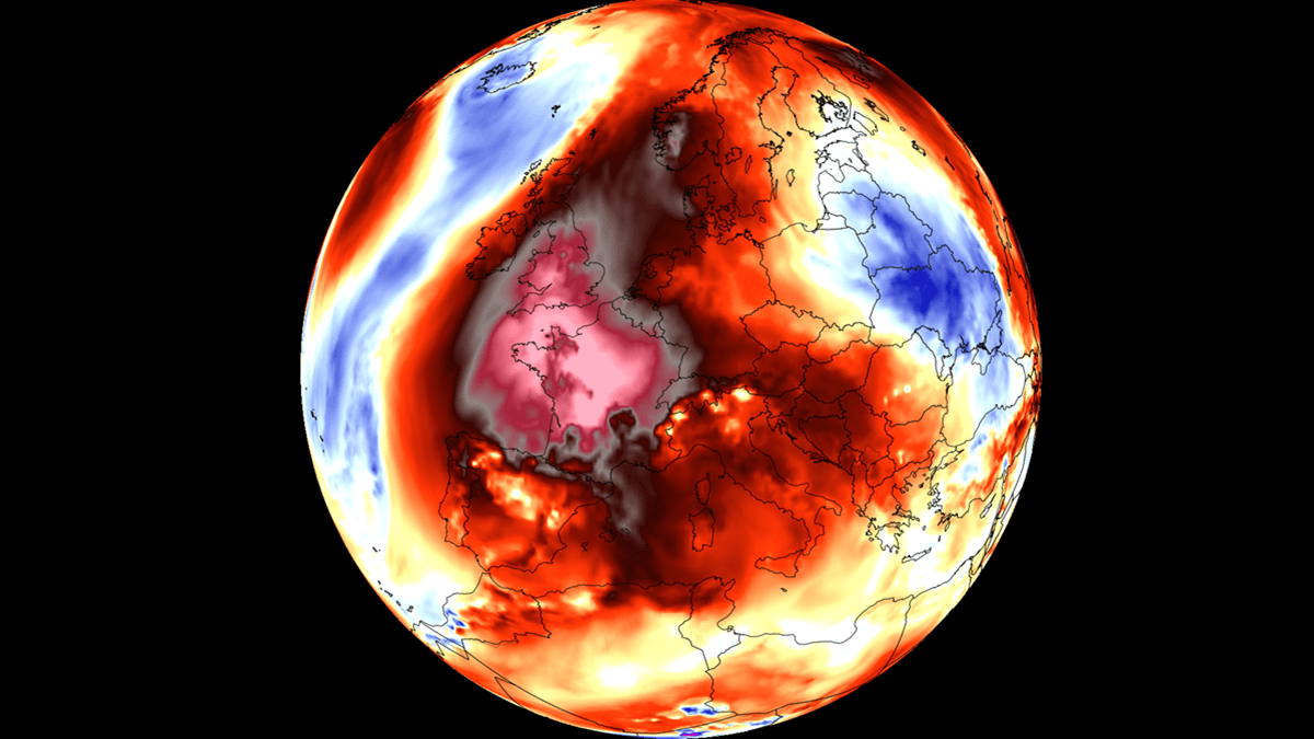
The daytime high temperatures are consistently 10 to 15 °C above historical normals, with core regions in the Iberian Peninsula and southern France testing the low to mid-40 °C threshold. Similar to June’s historic heatwave, the system’s overnight cooling cycle is failing to reset, resulting in ‘tropical nights’ in major urban centers like Madrid and some others.
The lack of precipitation combined with rapid evaporation rates is accelerating soil moisture deficits, elevating the regional wildfire risk vector to critical levels. Major and destructive wildfires are already ongoing from Portugal to Spain and southern France. This is where temperatures rose well above 40s these days, with very low relative humidity. Heat stress and fire dangers are extreme.
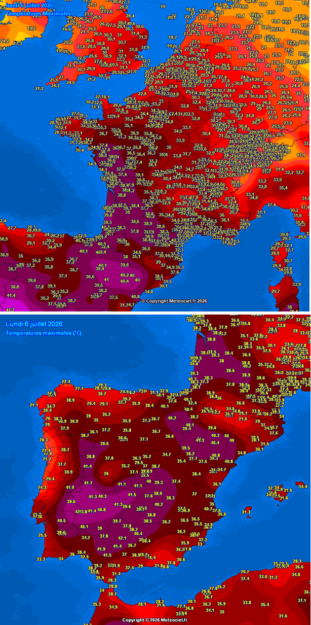
The current weather forecast models suggest this ridge will remain structurally stable with minimal changes for at least another week, maintaining an extreme heatwave through mid-July.
The soil in many regions remains exceptionally dry after a record-breaking hot spell Europe experienced in late May and the historic heatwave in late June, both obliterating hundreds of monthly and also all-time station records. With the forecasted prolonged heat and lack of precipitation, the conditions will worsen in the coming two weeks with multi-day stretches of 35-40 °C for many regions.
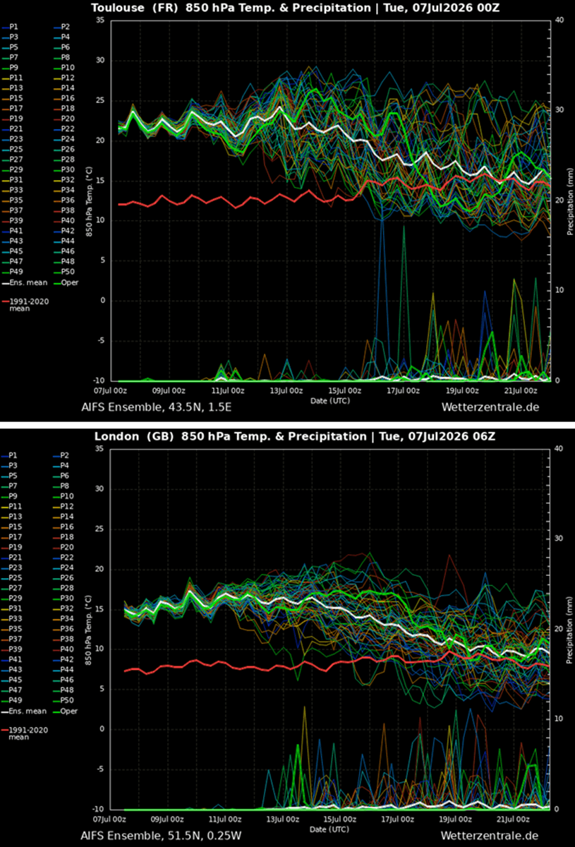
It will remain extremely hot across France, Spain and Portugal, gradually expanding across the rest of Western and then Central Europe as the Heat Dome strengthens and expands northward and eastward over the weekend and into the following week.
The driving force behind this pattern is similar to the one in June, a strengthening upper-level ridge building out of Northwest Africa and expanding a major warm plume across western and central Europe. The following animation delivers a quick overview.
Before we dig into the details about the pattern evolution in Europe, lets examine what is the main driver behind these extensive warm waves and heatwaves in general.
What is a Heat Dome?
When significant, record-breaking heatwaves occurred in Europe, the United States, and Canada in the past, the Heat Dome was a contributing factor. The heat dome is usually the dominant feature of summer weather patterns on both continents.
We refer to this phenomenon as a heat dome when extremely high temperatures develop. Here’s how it works and why understanding it on a broader scale is essential.
The upper-level ridge pattern, or very warm air mass in the higher altitudes, also known as the Upper High (or blocking High), usually forms the heat dome. This weather pattern brings high, and sometimes record-breaking, temperatures to the region below.
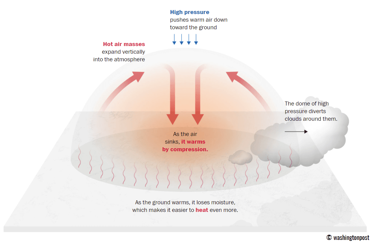
This term is used when a broad area of high-pressure air parks over a large portion of the continent. If the event is remarkably stable and extreme, it usually lasts several days or weeks.
The heat dome works like a lid on a pot. The extensive dome traps warm air at all levels underneath, with layers sinking toward the ground. Therefore, the air mass becomes anomalously warm at the lowest elevations and extremely hot near the surface.
How does a heat dome affect life beneath it?
Excessive heat in heat domes can significantly impact human health and be dangerous to particularly vulnerable populations, such as elderly individuals, children, and those with pre-existing health conditions that can be worsened by extreme heat.
Due to prolonged exposure to high temperatures, construction workers, farmers, and other long-hour outdoor workers are at increased risk of heat-related illnesses. People living in poverty are also more susceptible to the fatalities of heat domes, as their houses are often built with heat-trapping surfaces such as concrete and asbestos.
Heat exhaustion occurs with prolonged exposure to high temperatures. It leads to dehydration, dizziness, and, in more severe cases, heat exhaustion can progress to heat stroke.
High relative humidity during a heatwave can also significantly affect the body. For this reason, we use the Heat Index to represent the perceived feel of scorching-hot temperatures and high humidity. It illustrates the natural relationship between temperature and humidity.
A large Heat Dome re-develops across Western Europe
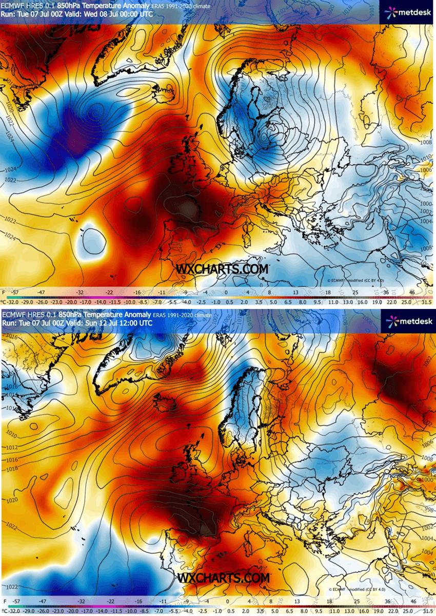
The weather pattern over the North Atlantic and Europe takes a classic summer shape, with a major blocking High built up over the western part of the continent, followed by a significant warm plume expanding northeastward from northwest Africa into southwestern and western Europe.
Notice an unseasonable deep low over northeast Europe; this is an intense frontal disturbance emerging over the Baltic region over the next two days. It will not have any effect further west as it drags southeast into the weekend and weakens.
The extensive upper-level ridge on the west will gradually expand northward and eastward, dominating most of the European continent throughout mid-July.
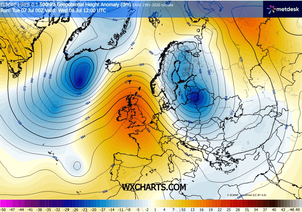
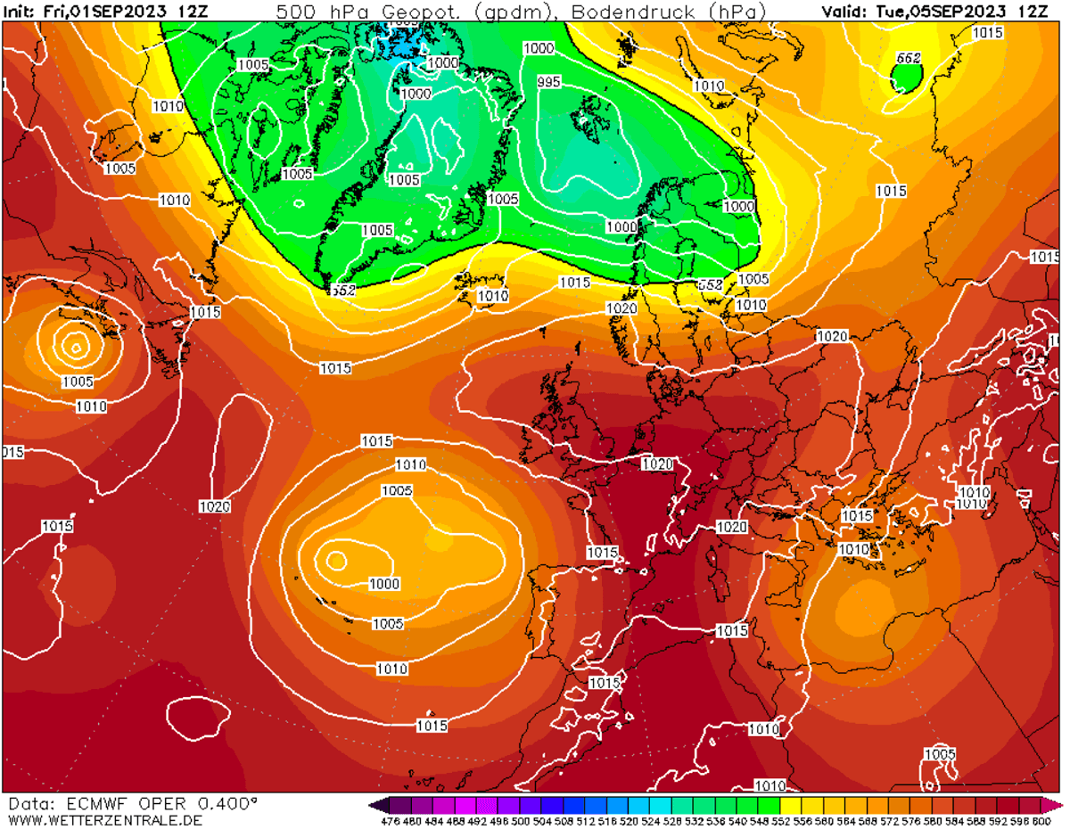
The medium-range ensemble guidance (ECMWF and GFS) indicates that 500 mbar geopotential heights and 850 mbar temperatures will reach high, near-record levels over the next two weeks. With this heat dome, temperatures are climbing exceptionally high as the upper-level subtropical air mass expands.
These anomalous upper-level heights at 500 mbar represent a highly anomalous late-spring tropospheric setup. With sinking air (compression and warming at the surface), surface temperatures will continue to exceed the 40 °C threshold into the weekend and next week as well.
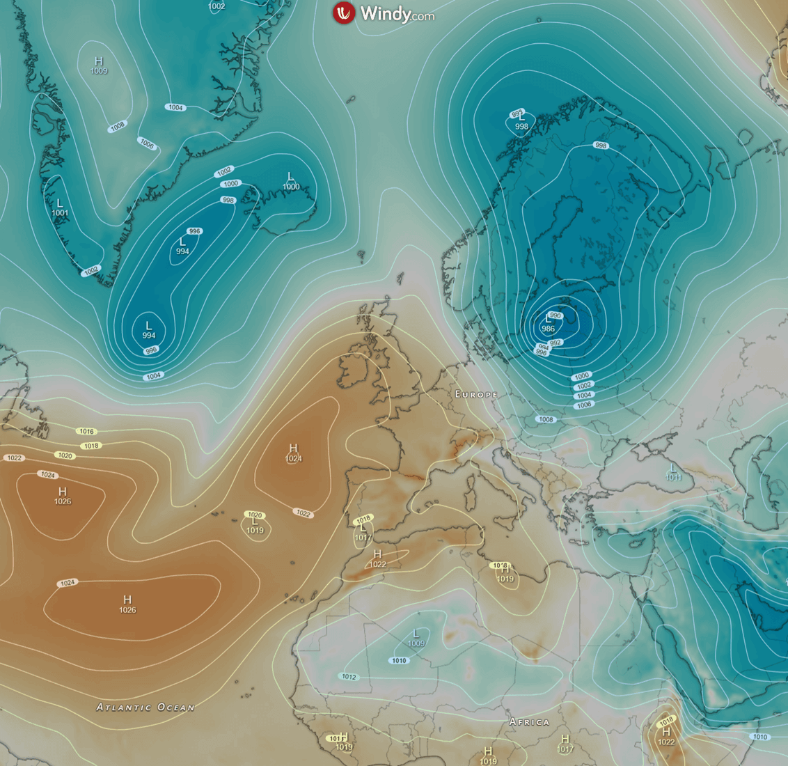
The sinking air within the heat dome also translates into rising pressure beneath it, thereby developing a surface high-pressure system centered over Western Europe, with higher-than-usual pressure across Western and Central Europe.
No significant disturbances are foreseen from the Atlantic, except for western Iberia, so the heatwave will be severe and long-lasting.
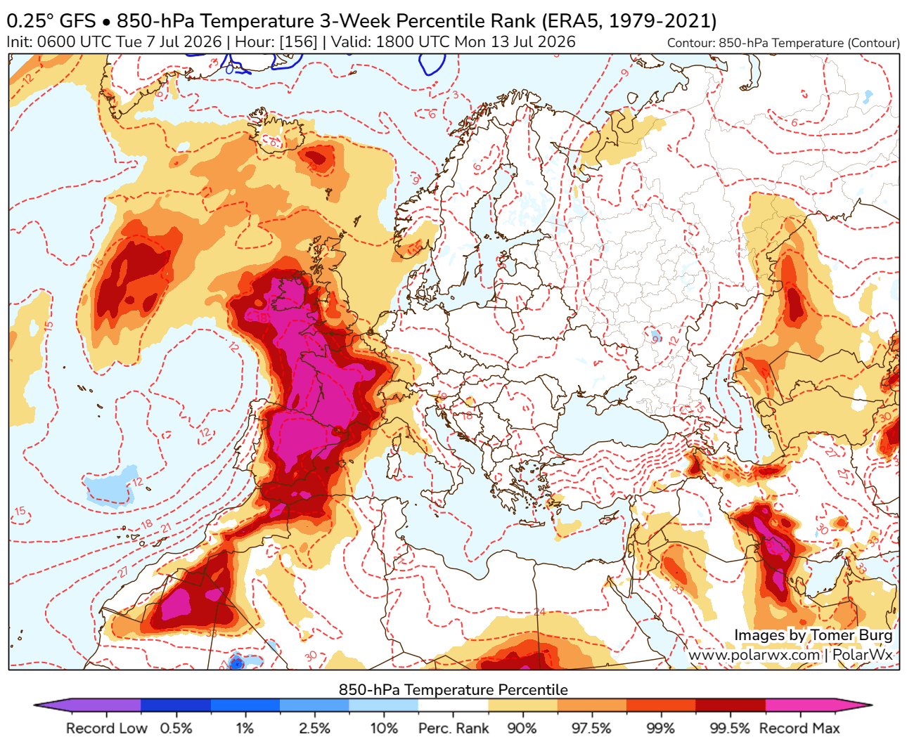
The significantly warmer air mass will gradually expand northward and eastward as we approach the weekend, with temperatures continuing to climb higher across southwestern Europe and spreading across much of western Europe.
Until early next week, the warmest and most anomalous air masses will be over Spain, Portugal, France, and the UK. Temperatures are forecast to gradually spread further north and east by early next week.
Near-surface temperature anomalies are already extreme across Spain and Portugal this week, surging northward into France and the rest of western Europe in the coming days. They will also spread east towards Italy and the Alpine region.
Temperatures will be 12-16 °C above normals for mid-July, potentially even higher locally with the most anomalous air mass again across western and central France. Similar to the historic heatwave in late June.
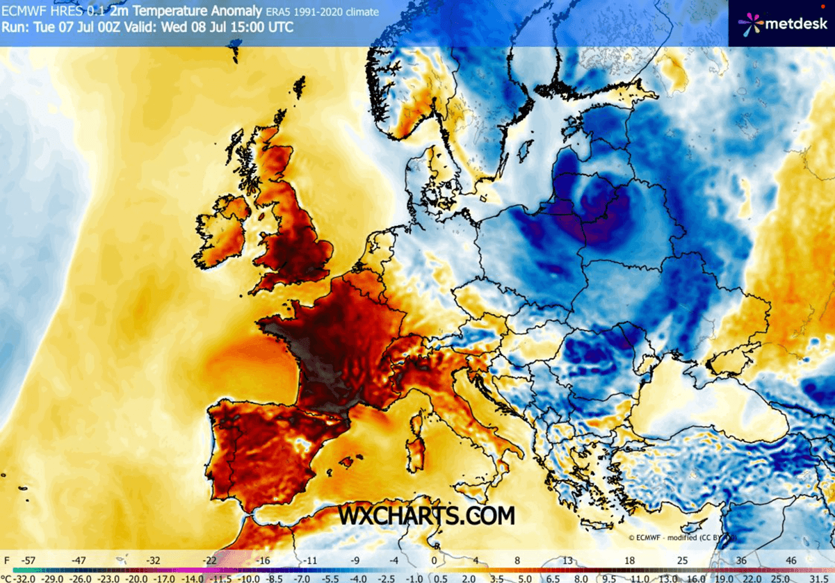
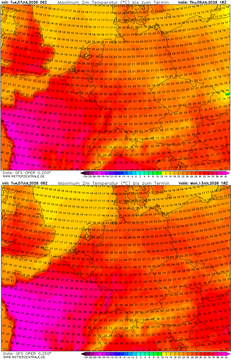
Therefore, daily highs will continue to reach the upper 30s to low 40s in some regions, and push into the mid-40s from Spain to western France.
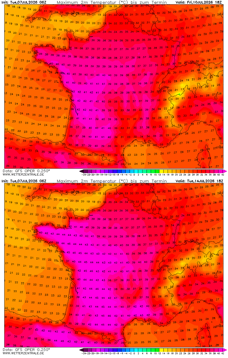
The powerful heatwave re-establishes long-lasting excessive heat with temperatures near 40 °C
The significant warmth and heatwave have already spread over southwestern France early this week, with peak daytime temperatures reaching into the low 40s in places. The hottest air mass is yet to arrive, with temperatures surpassing the 40 °C mark in the coming days as the heat dome spreads further north.
Some weather models hint at exceptional heat developing after Sunday, with peak afternoon temperatures potentially reaching up to 45 °C across much of central, western, and southwestern France. This could challenge some regional historic heat records for July.
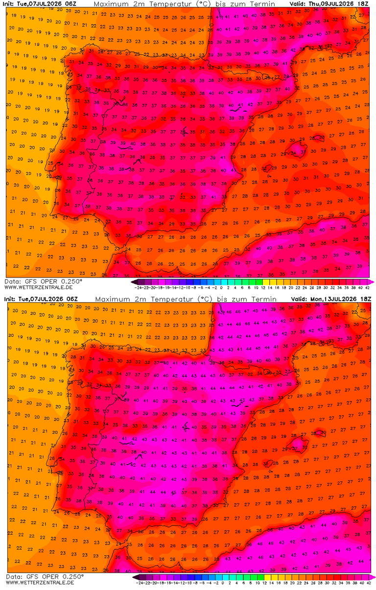
With the strengthening ridge aloft and an associated warm plume, temperatures have already climbed significantly across southwestern Europe. They were reaching near 41-43 °C across Portugal and Spain these days, while a shallow disturbance from the Atlantic will bring some heat until the weekend. The daytime highs should remain in the upper 30s or near 40 °C, a few degrees lower than in previous days.
Scorching heat, however, is likely to return after the weekend as an upper-level heat dome restrengthens and shifts its core back to the southwest, so temperatures will again locally push into the low 40s °C by early next week and extend into mid-July.
The British Isles will also gradually experience much hotter days, with temperatures in the mid-30s late this week and over the weekend as the heatwave expands north. Based on the latest model guidance, temperatures are not forecast to climb towards the 40s mark this time.
Nonetheless, the coming days should allow near-surface temperatures to reach the low to mid-30s across south-central England and Wales, with the mid- to upper-20s elsewhere. Ireland will also experience mid- to upper-20s until next week.
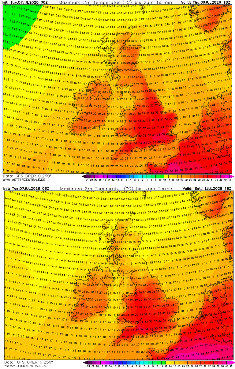
Warmth will also gradually expand into Germany and the Benelux as we head into the weekend, but it will not reach extreme temperatures yet. This happens because the heat dome remains parked over Western Europe, including France and the British Isles, for a while.
The highest temperatures over western Germany and the Benelux should reach low to mid-30s through the remainder of the week, but conditions are monitored for a heatwave to escalate next week.
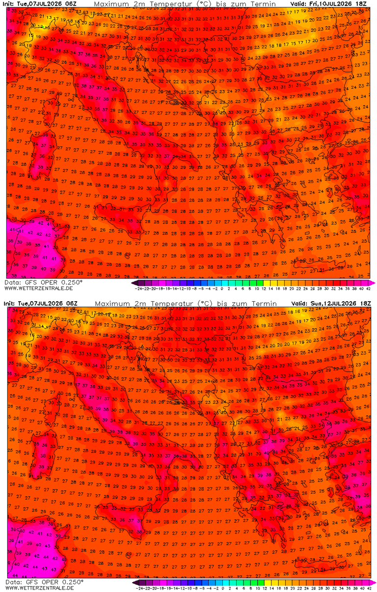
Temperatures will also gradually rise in central Europe and the Mediterranean towards the weekend, with parts of Italy reaching the upper-30s. With the heat dome gradually expanding as we head towards mid-July, excessive heat will develop.
It will also become much hotter across the Balkans, with temperatures in the mid to upper-30s; they are not expected to get much higher due to the blocking ridge remaining further west, persisting over France.
The hottest air mass, however, will be across southern Italy and the Balkans, with local areas potentially peaking daytime highs into the 38-41 °C range next week.
The overall heatwave effect is likely to persist through mid-July, as suggested by midterm trends, so the accumulating heat will be long-lasting, worsening drought conditions and supporting additional dangerous wildfires. The soil is already exceptionally dry in many areas, and it will get worse.
We will be monitoring the ongoing development of the significant Heat Dome and will update the forecasts accordingly as the situation evolves next week. Stay tuned.
Stay tuned for updates.
Wxcharts, Wetterzentrale, and Meteociel provided images used in this article.
See also:
A Cold Atlantic Anomaly Returns as Super El Niño Shapes Winter 2026/2027 Early Forecast Signals