A dynamic and progressive weather pattern over Europe is forecast to produce another intense winter storm this weekend. A deep low will emerge into western Europe and intensify into a large snowstorm, resulting in wintry conditions across a large part of the continent through early next week.
The progressive weather pattern over the North Atlantic and Europe is nowhere near its end, as numerous troughs are emerging into the European continent with the zonal flow. One intense system is now shaping up on the horizon.
Thanks to the large blocking High developing over the Atlantic, winds will turn northerly and push colder air mass into western and central Europe, inducing an intense winter storm from Friday through Sunday. Many areas will see heavy rain and snow, and local travel conditions will be difficult.
Following the blocked flow over the North Atlantic, a dominant feature will be a significant high-pressure system, paired with the deep low moving from the UK into Benelux, Germany, and the Alps over the weekend. Intense wintry weather will be established along the associated front’s path.
The flow between the High and Low will allow the cold airmass to spread far south into western and southwestern Europe, including northwestern Africa. This will bring fresh snow into higher terrain over the Iberian Peninsula, Pyrenees, and Alps.
The main interesting feature will be a rapidly emerging Atlantic storm that will enter Ireland and the UK on Friday and mature into a large frontal system as it spreads across the rest of Western Europe on Saturday.
The winter storm will move further southeast Saturday night and introduce a secondary low over the northern Mediterranean, resulting in a big snowstorm for the Alps and surrounding areas.
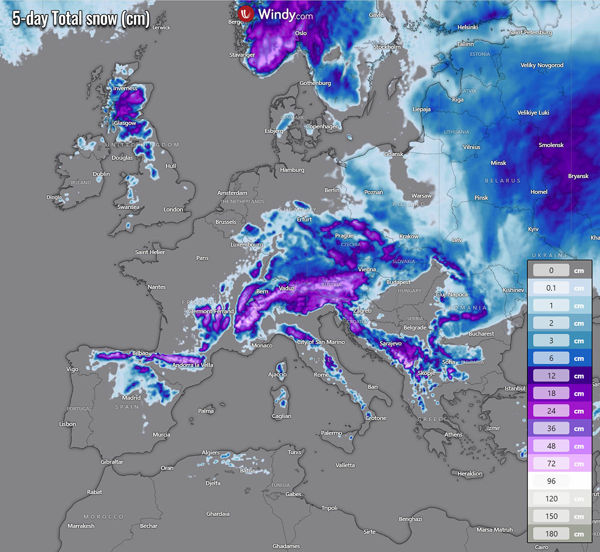
Below are the 5-day snowfall totals across continental Europe. Fresh snow is forecast in many areas, including the northern UK, northern Iberia, the Alpine region, the western Balkans, and central Europe. There is also more snow across Eastern Europe and Scandinavia.
Weather and travel conditions will deteriorate quickly over western and central Europe as a winter storm grazes into the continent over the weekend.
Let us discuss the upcoming pattern evolution and forecast details for this weekend’s significant winter storm.
A major winter storm is forecast for Europe as a progressive pattern continues
A large upper-level high will establish over the North Atlantic, shaping the weather pattern over the weekend into early next week. Blocked zonal flow will induce a cold intrusion from the Arctic region into western Europe.
Therefore, a deep closed low will emerge into western Europe on Friday, intensifying and deepening through Saturday and Sunday while moving towards central Europe and the Alps.
At the surface, a rapidly deepening low will be moving across Ireland and the UK on Saturday.

It will become a very large system, dominating the European continent through early-mid next week. These two large-scale features will result in intense upper winds between the Atlantic’s blocking High and Central European deep low and rounding the base of the trough.
The following chart shows the intensity of the established zonal flow for winds at 500 mbar geopotential level, roughly 8 km above the ground. The core of the jet stream is connected with the polar jet stream further north.

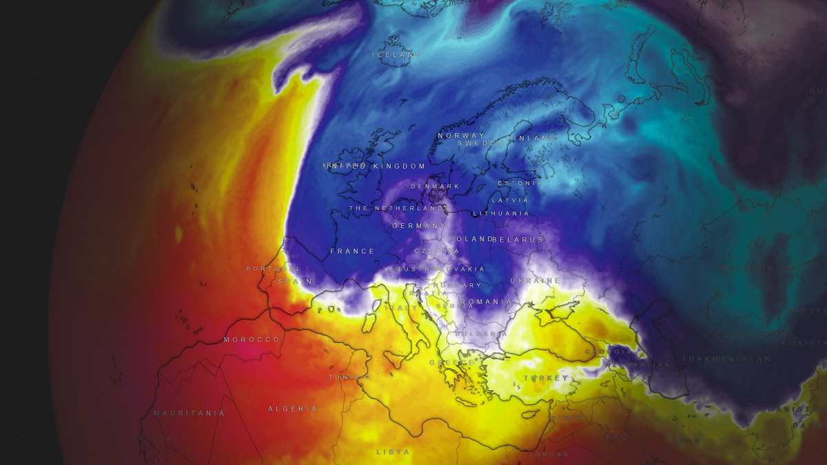
The large trough will allow Arctic airmass to advect into Western Europe through the early weekend, gradually progressing south through early next week.
The large cold pool will remain in place for several days, establishing conditions for precipitation to turn into snow in many regions.
Starting Friday morning, an Atlantic storm emerges from the west into Ireland and the UK while deepening its central pressure into the low 980s. A frontal system will quickly move across the region, with heavy rain and gale-force winds near the core. Peak gusts could reach around 90-120 km/h across southern UK.
Some snow will be possible on the northern side of the low through Friday afternoon into early Friday night across the north UK and Scotland.
By Saturday morning, the system will be growing larger as it matures. Its central pressure will drop below 980 mbar while moving across the Benelux. Snowfall will spread across southern Scandinavia while the cold front is pushed towards the Alps.

A widespread cold, maritime air mass will spread in the system’s wake across Ireland and the UK into France late Saturday, introducing winter showers with graupel and snow locally. Strong winds will blow across western Europe through Sunday.
A secondary low forms under the deep low over the Alps, intensifying the winter storm for the region
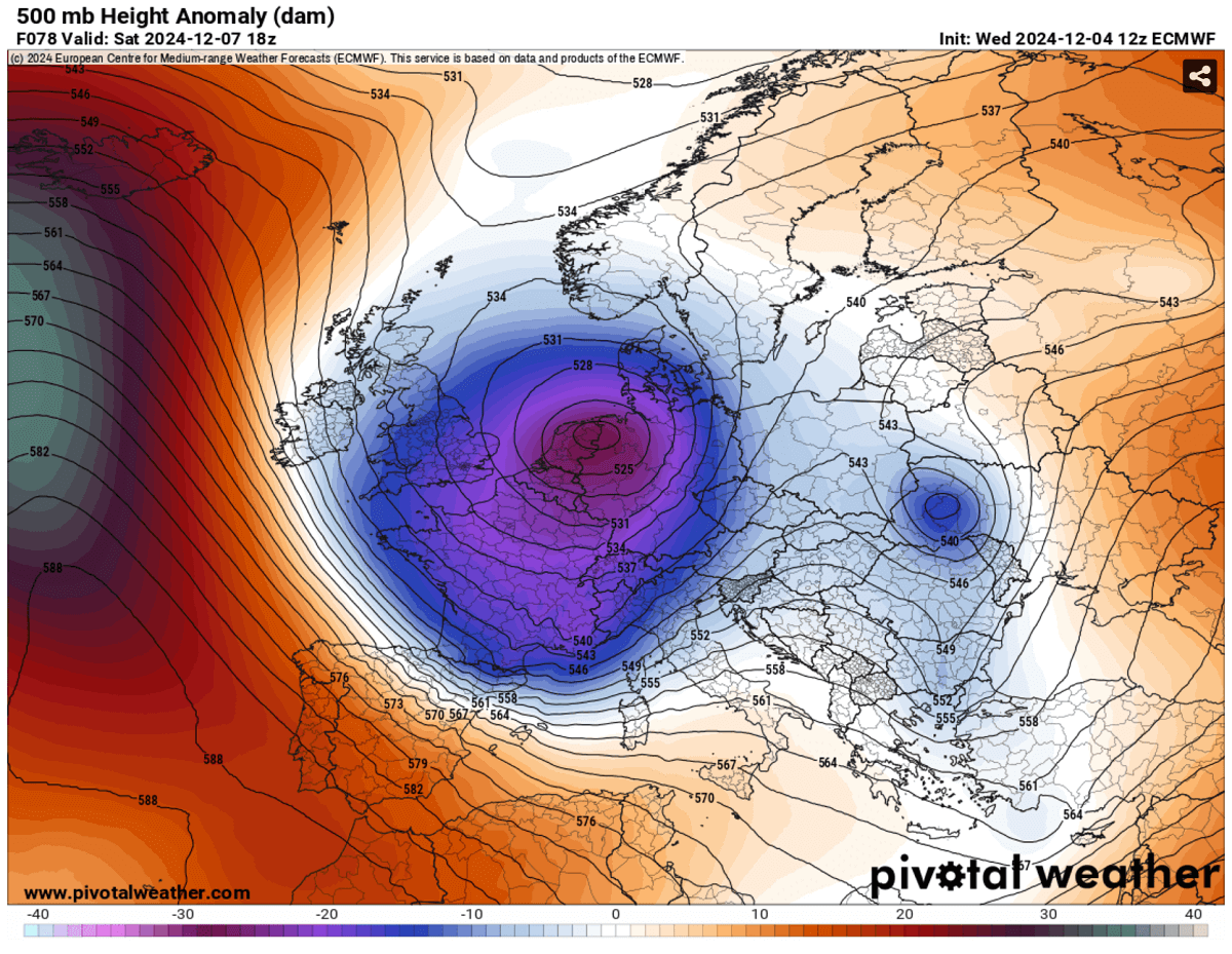
A significant geopotential anomaly develops on Sunday and Monday as the North Atlantic ridge, and the closed low over central Europe strengthen. A huge contrast will be established between the two large-scale features.

The deep through over central Europe will be large, establishing a winter storm for the Alpine region beneath. Notice the extreme positive anomaly in the upper levels over the North Atlantic near Iceland.
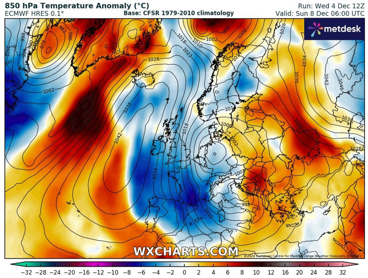
As a result, significantly high surface pressure will occur over the Atlantic, with central pressure nearing 1050 mbar between the UK and Iceland.
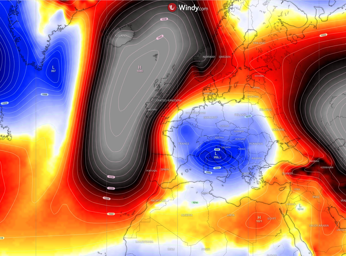
Further southeast, over central Europe, a deep secondary surface low will occur beneath the pretty cold upper levels aloft.
This intensifies the frontal system, crossing the Alps, northern Mediterranean, and northern Balkans regions. The cold front will turn rain to snow from late Saturday into early Sunday morning from north to south across the Alps.
Heavy snow will take place over Austria and parts of Slovenia.

Some snow is forecast to accumulate across the Alpine region over the next five days, from southeastern France to Switzerland, Austria, and Slovenia. While the system will gradually weaken as it moves south on Monday, snow will also develop along the Dynaric mountain range in the western Balkan peninsula.
Snow will likely accumulate across southern Germany, Czechia, and Slovakia by early next week.

The cold pool established between the large Atlantic blocking High and deep low over central Europe will maintain cold weather over southwestern Europe through mid-next week, with the coldest anomalies on Tuesday and Wednesday.
Days will be much colder than normal across Spain, Portugal and France.

Windy, PivotalWeather Wxcharts provided images used in this article.
See also: https://www.severe-weather.eu/long-range-2/winter-2024-2025-europe-final-forecast-late-potential-fa/