BCC is the Beijing Climate Center from Beijing, China. BCC organizes and coordinates research efforts on regional climate, operational predictions and climate application and services. It also provides climate services to China and other Asian countries for disaster prevention and mitigation.
BCC as a climate center, also runs their own long range modelling system, called BCCCSM_1.1m. It is the second generation climate modelling prediction system from BCC.
All these forecasts are an average picture over 3 months (Dec-Jan-Feb), and show the general prevailing weather pattern. Even if the models would be completely accurate, it does not mean that such weather conditions would last for 3 months straight. There can still be cold fronts and snowfall in between such milder patterns in the mid-latitudes. The difference is that instead of the usual 10-20 snow days for example, you only get 3-6 snow days (as an example). So the models don’t suggest what the weather will be like for 3 months straight, but just how it might look 40-60% of the time.
Upper level forecasts.
We always want to know how the pressure forecasts look like. That tells us a lot about the overall global circulation and weather patterns. You can learn more about the importance of long range pressure forecasts in our previous post, that contains basic information that you need to know about long range forecasts, and graphics from the September model runs to compare:
Winter 2019/2020 early look (September) and LONG RANGE THEORY.
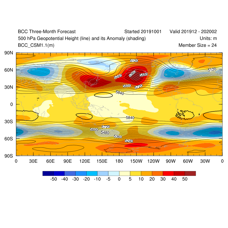
Unlike the Euro-USA modelling systems, we see a different story with this forecast system. We have a deep broad low, but not in the North Atlantic. Instead we have the main low core over east Canada, and one over eastern Europe. This is not the classical positive NAO pattern that you can see on the other long range forecasts. Such pattern would promote northerly flow across western USA, and north/northeast flow over Scandinavia down into central Europe, on the edge of that east European low.
Staying at altitude, we have the 850mb temperature forecast, which is on average around 1.500 m altitude in the mid-latitudes. Here, we can see what we expected from the 500mb height forecast in the USA, colder air coming down from Canada into USA over western parts. But we see no hints at any colder anomalies over Europe.
Surface levels
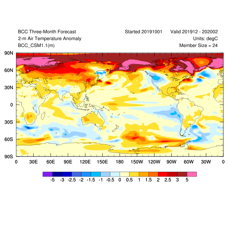
One of the most used long range parameters is of course the 2-meter temperature anomaly forecast, also simply referred to as the surface temperature forecast. It is the main forecast to tell us what to expect in terms of temperatures (warmer/colder). We can see the colder forecast for west/northwest USA, as emphasized from the pressure forecasts above. But we have no colder air anomalies over Europe, which should be present over Scandinavia and parts of east/central Europe. We see the whole polar circle is under above average temperatures, which does not completely agree with the pressure forecasts above.
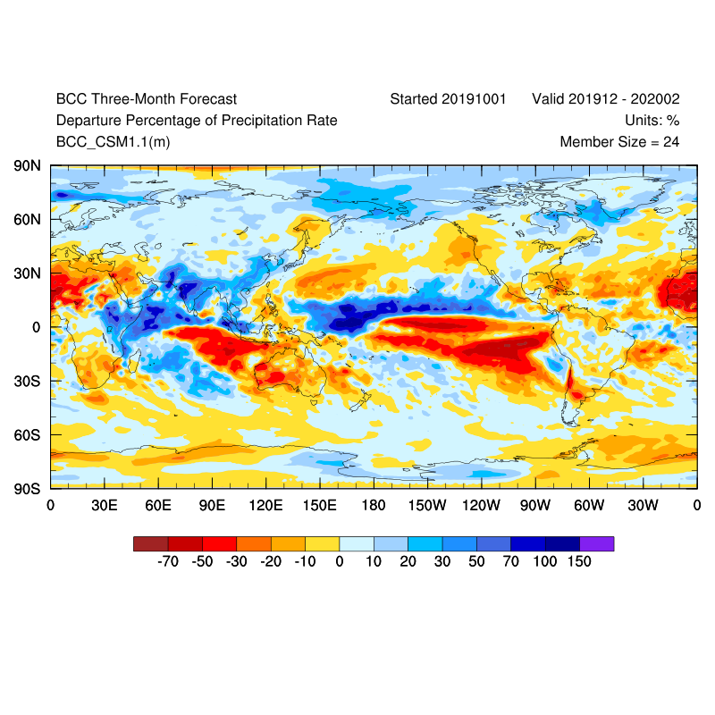
Looking at the precipitation forecast, we have wetter than normal over UK and northern/eastern Europe, and drier than normal across southwest and southern Europe. In the USA we see wetter conditions over southern and central parts, as a result of the low pressure over central parts.
To summarize, the BCC forecast from October shows a different forecast than other main global long range systems. It has more winter emphasis in the west/northwest USA, and hints at possible winter conditions in parts of east/central Europe form the pressure forecasts, but not from the temperature forecast.
We still have the stratosphere as a major factor. Long range forecasts are generally not as good at forecasting stratospheric dynamics in detail, which means they tend to underestimate any potential sudden stratospheric warming events (SSW’s), since the final forecast is made out of many individual calculations, which have different ideas about the stratospheric development. An SSW event can have a major impact on the circulation and can cause major pattern changes in the Northern Hemisphere. So a potential SSW event is an important factor that can change the course of winter in either way across the North Hemisphere.
There are more long range models waiting to be explored, so click below to go back to the model selection page:
GO BACK TO MODEL SELECTION


