The first forecast trends for Summer 2023 are emerging and show a different picture than last year. Some of that has to do with the La Nina now starting to disappear, with an El Nino forecast to emerge during Summer.
When trying to understand any weather season and long-range forecasts, we must realize that many global drivers can shape it. Global weather is a very complex system with many large-scale and small-scale factors.
Seasonal forecasting focuses on large-scale pressure systems and the jet stream positioning with the weather pattern. Over the Northern Hemisphere, this upcoming Summer season will be a transition period between the La Nina and the El Nino, giving other factors more importance until the shift is complete.

WEATHER SEASONS CHANGE
We are currently in the Spring season. So before looking at the early trends for Summer, we will quickly recap the Winter 2022/2023 season. The meteorological Winter season covers the months of December, January, and February.
Starting off with the basics, we have the main pressure pattern. This shows us the geopotential height anomalies and how the jet stream behaves. It basically drives the Winter temperature and pressure patterns.
Looking at the analysis, we can see a large and strong high-pressure anomaly in the North Pacific. That is the high-pressure zone from the La Nina influence. You can see a low-pressure zone covering western Canada and an even stronger system over the western United States.
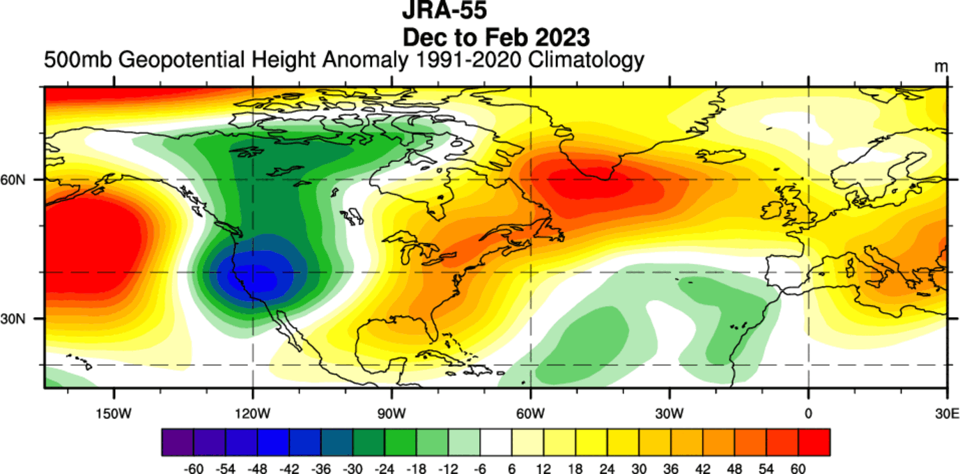
A high-pressure zone extended over the eastern United States, connecting with the high-pressure over North Atlantic. Over Europe, we mainly see a high-pressure anomaly over the mainland and a low-pressure anomaly over the far southwest and the north.
TEMPERATURE ANALYSIS
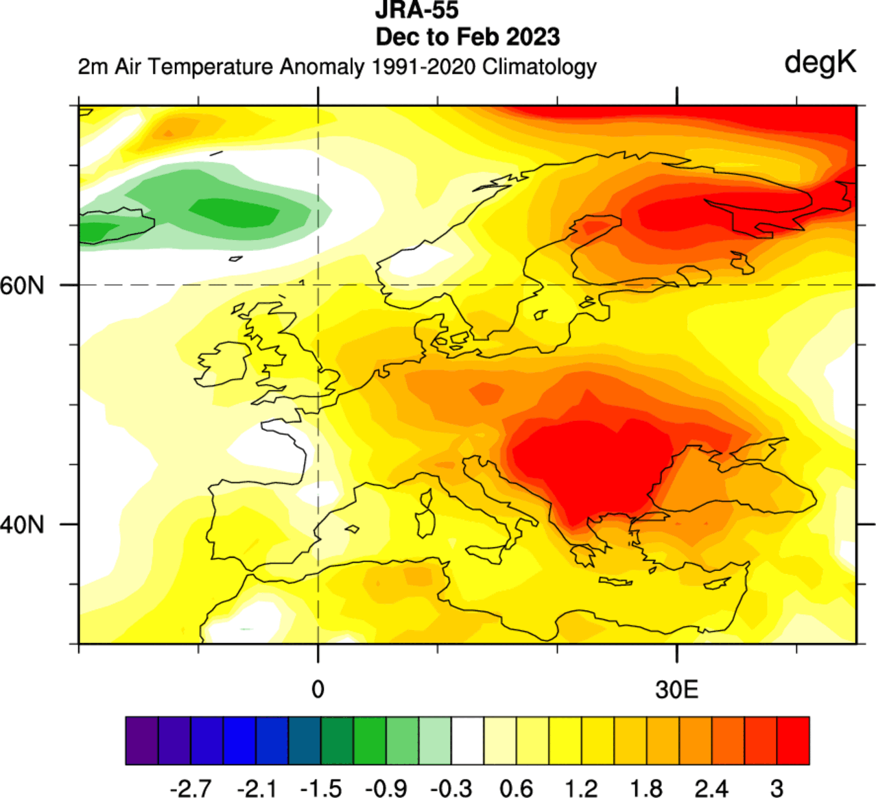
Looking at temperatures, we have the Winter temperature analysis for Europe below. Most of the continent was warmer than normal, with stronger anomalies over central parts and far northeast.
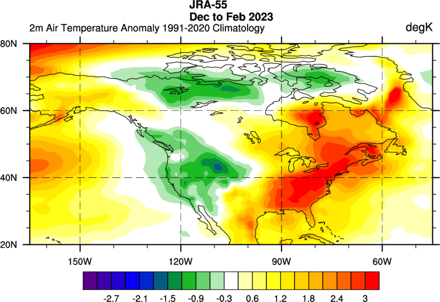
Going over the United States and Canada, the Winter analysis shows most of the eastern United States and Canada was warmer than normal under the high-pressure zone. But cold anomalies were present over the western United States and northern Canada.
Looking again at the more detailed temperature analysis for theUnited States from NOAA/NCEI, we can see a colder winter than normal over the western United States. However, the Winter season was much warmer than normal over most of the eastern United States.
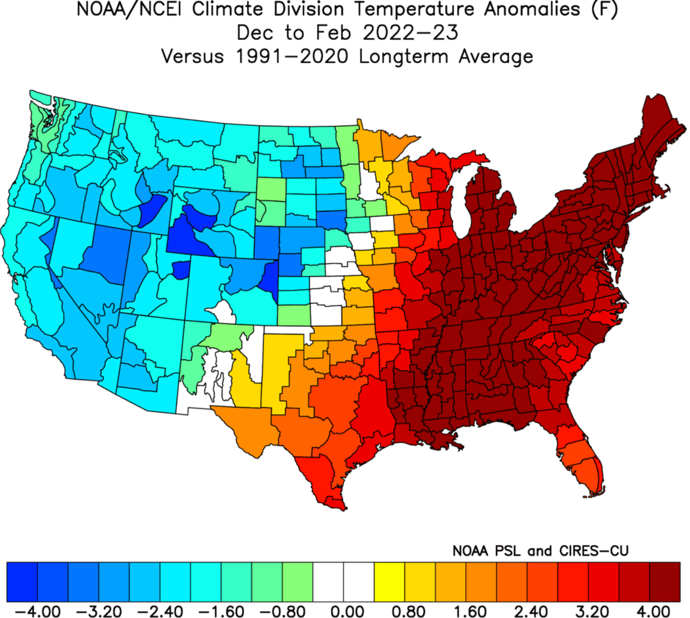
This produced a special “dipole” weather pattern over the United States. It was more pronounced in the early and latter stages of the Winter season.
PRECIPITATION ANALYSIS
The precipitation pattern over Europe was wetter over much of the continent. The exception with drier conditions was west-central Europe and the British Isles.

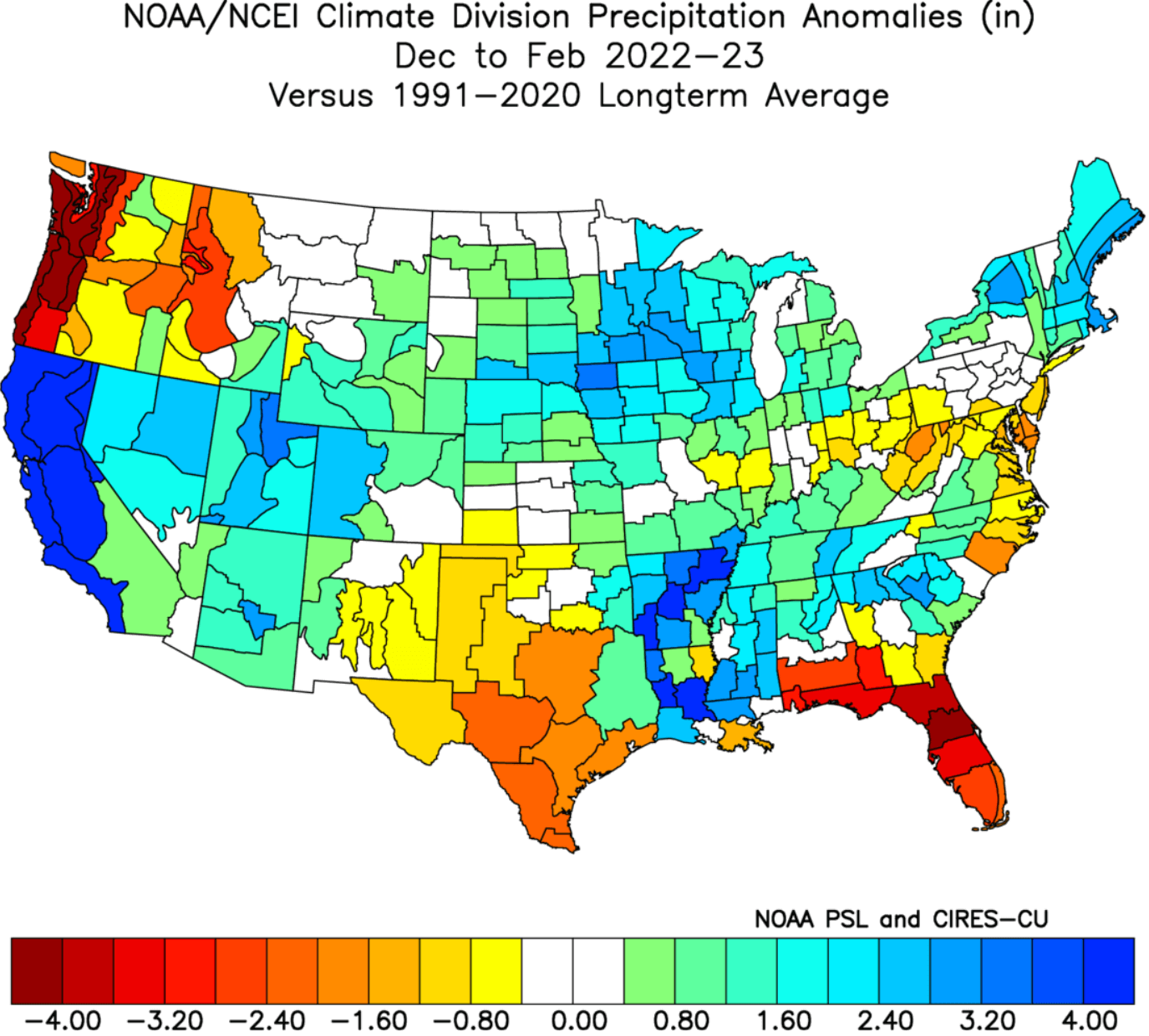
Looking at North America, you can see the Winter precipitation anomaly analysis. More precipitation was over the Ohio River Valley and up into the Great Lakes. The biggest wet anomaly is seen over California, with much more precipitation than normal.

Mostly drier conditions prevailed over the south-central and southeastern United States and the Pacific Northwest.
Looking at the more detailed analysis by NOAA/NCEI, we can see much wetter conditions over California. This winter season was generally wetter over the United States, with the main dry exception being the Pacific Northwest, far south-central states, and the southeastern states.
LA NINA SEASON ENDS
One of the main drivers behind the Winter weather patterns was the La Nina. This is a cold phase of an oceanic oscillation called ENSO. It is found in the equatorial Pacific and alternates between warm and cold phases.
The cold phase of ENSO is called a La Nina, and the warm phase is called an El Nino. Each phase has its specific influence on the pressure patterns and the resulting weather.
For a better idea of the ENSO development, we produced a video showing La Nina’s emergence last Fall.
The video below shows the cold ocean anomalies emerging in late Summer last year. Notice the “waveforms” across the region as trade winds push the surface waters west.
A strong blocking high-pressure system in the North Pacific is the most typical effect of a cold ENSO phase (La Nina). That usually redirects the polar jet stream down over the northern United States. You can see the La Nina winter weather patterns in the image below by NOAA Climate.
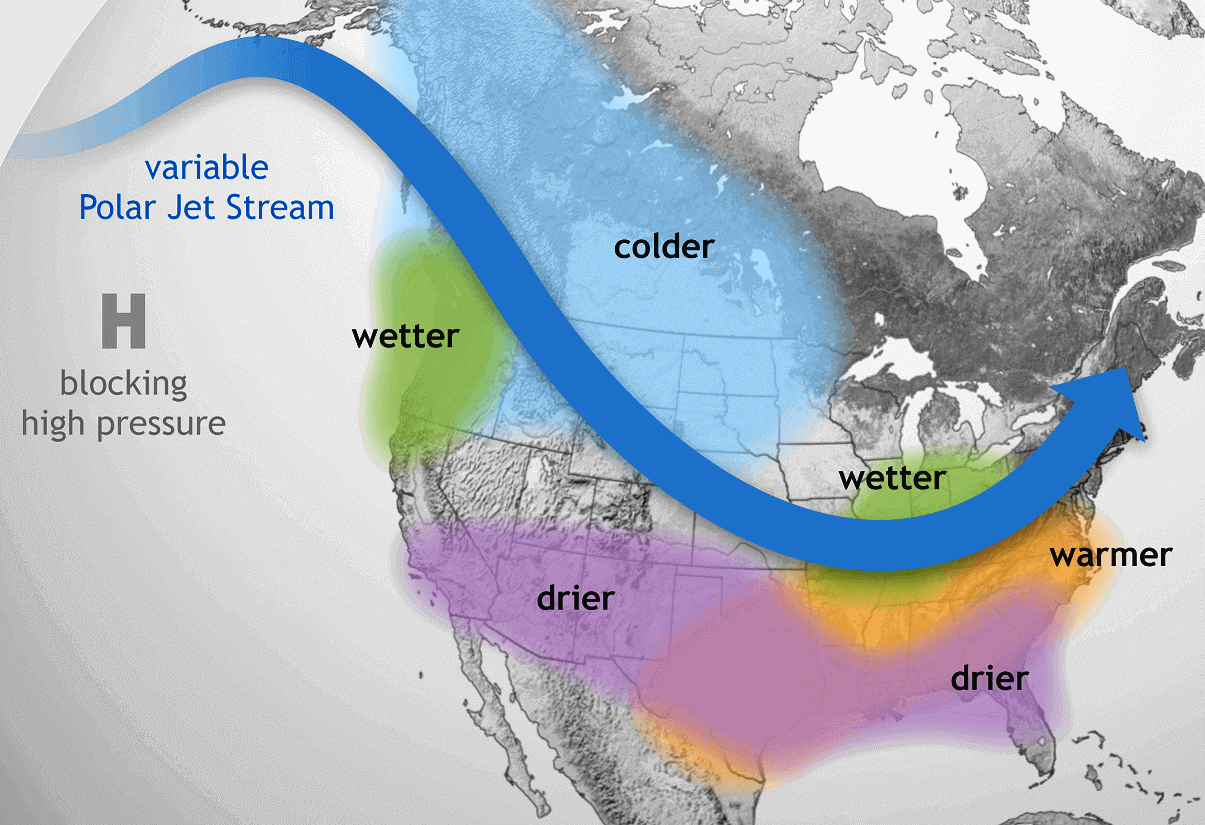
The colder air is typically spread over the northwestern United States, the Midwest, and western Canada. Warmer than normal winter weather is found in the southeastern and eastern parts of the United States.
This is a similar pattern to this past winter, with the exception of wetter and colder conditions over California, untypical for a La Nina winter.
Speaking of La Nina, below we have the ocean temperature analysis from late November before Winter began. You can see the cold ocean anomalies extending across the tropical Pacific. This was the mature active La Nina.

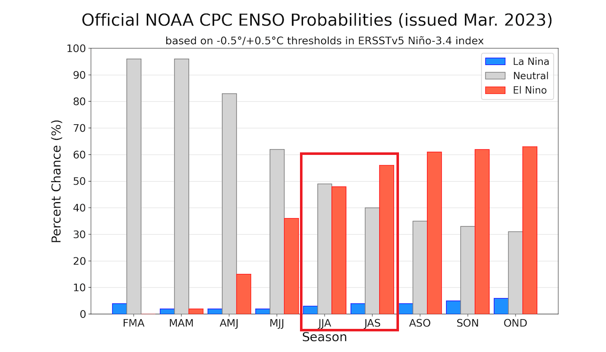
Looking ahead, you can see the neutral phase continuing until Summer. But during Summer, the chances are increasing that an El Nino event (warm phase) is likely to emerge, creating a very different weather pattern for the Winter of 2023/2024.
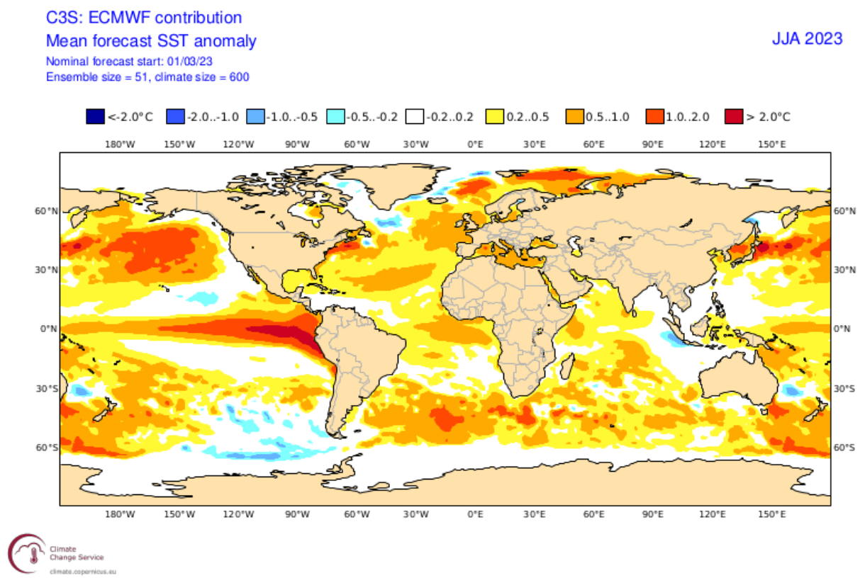
Below we have the ECMWF long-range ocean forecast, showing the temperature anomalies during Summer. You can see a strong belt of warm anomalies extending across the tropical Pacific. If this verifies, we could look at a proper El Nino starting this Summer.
But it’s time to look at the early weather trends for Summer 2023 across Europe, Canada, and the United States.
SUMMER 2023 FIRST LOOK FORECAST
We will examine the early trends from the two most used seasonal forecasting systems. The ECMWF from Europe and the CFSv2 from NOAA in the United States. We like using two very different forecasting systems, which helps us see more potential scenarios. It also helps to see how well the model agrees on a certain trend.
ECMWF is statistically a better long-range model, so we usually start with its forecasts.
ECMWF SUMMER SEASON FIRST FORECAST
Generally, the ECMWF model is at the top as far as “reliability” goes. But no long-range/seasonal forecasting system can be called “reliable“. This is because we only look at trends and how the weather patterns are evolving on a large scale and over longer periods.
The forecast period we will focus on in all models is June-July-August (JJA 2023). This period covers the meteorological Summer and is the peak of the warm season.
The pressure pattern forecast from ECMWF below shows a low-pressure area over eastern Canada and Greenland. A possible extension is indicated into the western United States. In addition, a ridging pattern is shown for the eastern United States and western Canada.
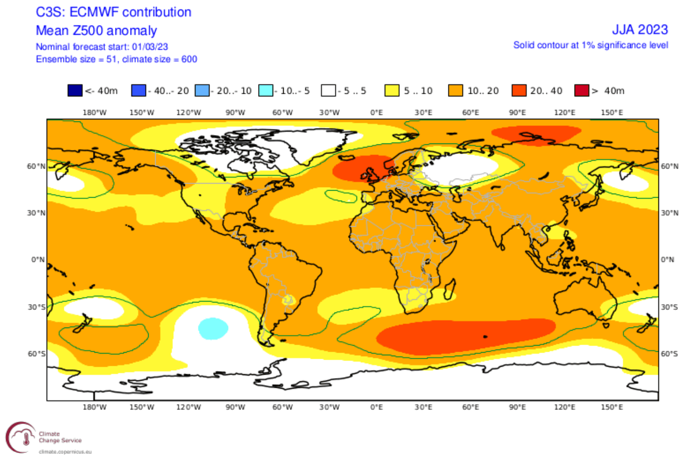
A stronger high-pressure area is found over northwestern Europe, specifically the United Kingdom and Ireland. Such a strong system can have a widespread influence on the Summer weather patterns in Europe.
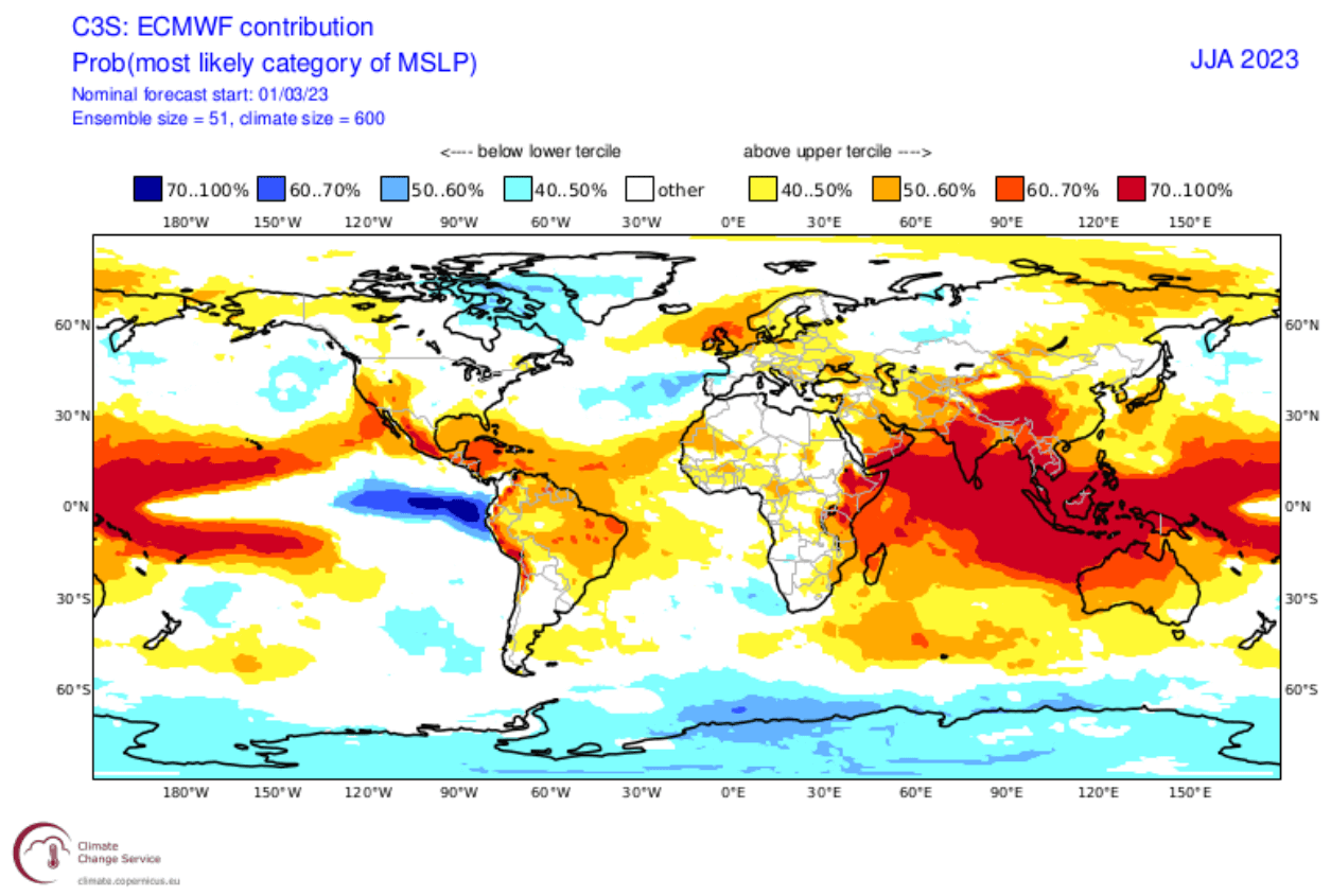
The surface pressure anomaly also shows an interesting pattern over the tropical Pacific. Low pressure is emerging in the eastern Pacific tropics, indicating an emerging El Nino. A low-pressure area is seen over eastern Canada and Greenland, and a blocking high over northwestern Europe.
Looking closer at the temperature pattern over Europe, we see warmer-than-normal weather over most of the continent. But the exception is found towards the northeast, forecast to be under the influence of a northerly flow. That is created by the clockwise rotation of the high-pressure system over northwestern Europe.
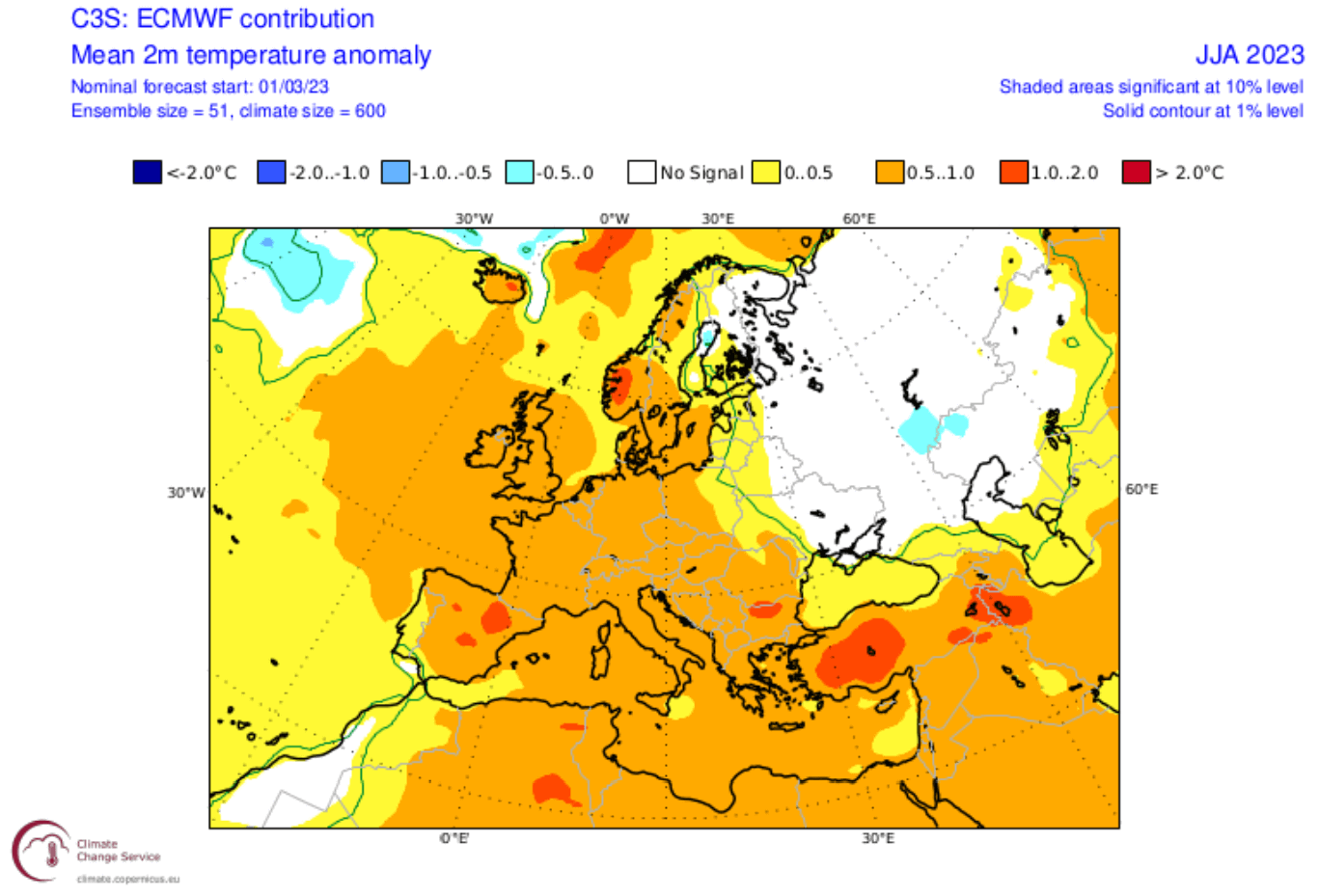
Over North America, we can now see mostly warm anomalies over much of the central and eastern United States and western Canada. Some exceptions are over the western United States. A low-pressure system indicated over the west can limit the intense heatwaves over the western United States but amplify them in the east.

Going to precipitation, we can see mostly drier conditions forecast over central and northern Europe under the high-pressure zone. However, wetter conditions are forecast over the south-central parts of the continent, also indicating a more active storm season.

The precipitation forecast over North America does not show many anomalies at the present time. But it does show wetter conditions over the Great Lakes and the northeastern United States. Eastern Canada is also forecast to see more precipitation.
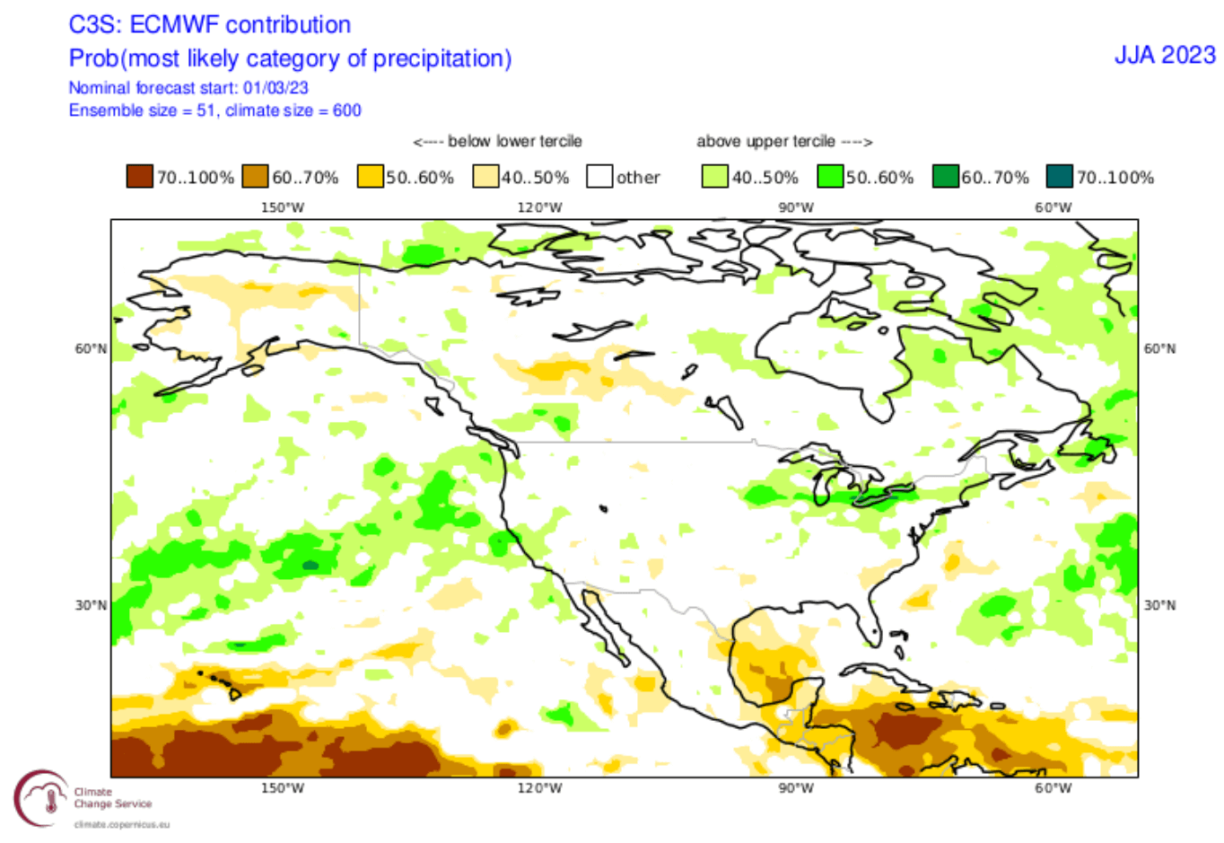
We are, however, looking at the early trends for Summer, so the precipitation picture will get more defined with new runs. But currently, the ECMWF is not forecasting strong drought conditions across the United States.
CFS SUMMER 2023 EARLY FORECAST
In contrast to the European models, we like to use the main North American long-range model, the CFS version 2 from the NOAA/NCEP in the United States.
The CFS model differs from the ECMWF, with a high-pressure system over eastern Canada and Greenland. But overall, it shows too many high-pressure zones across the Northern Hemisphere.

Looking closer at Europe, the surface temperatures are warmer than normal over most of the continent. A stronger warm anomaly is forecast towards the northern parts, under the influence of a regional high-pressure zone.
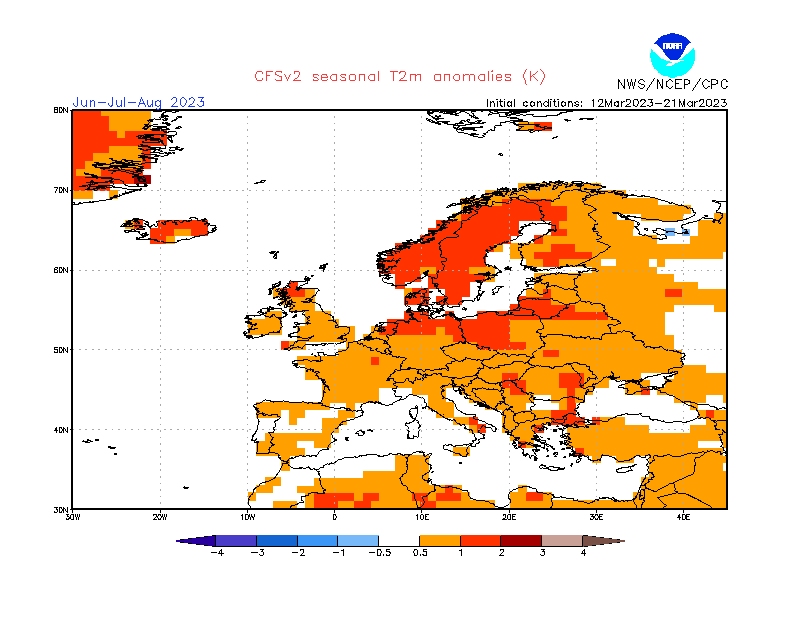
The North American temperature forecast below shows a similar picture to the ECMWF. Warmer over the eastern United States, and a gap over parts of the western United States. However, warm anomalies are still forecast over the Pacific Northwest.

What is different from the ECMWF is a strong warm anomaly over much of Canada, especially towards the northern parts, under the influence of a broad high-pressure zone.
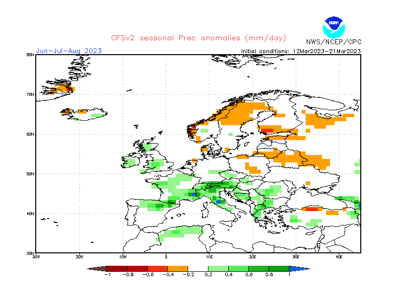
Looking at precipitation over Europe, we see mostly wetter Summer conditions across the continent. This is also a sign of a potentially stronger storm season if this forecast would verify. Drier conditions are forecast towards the north, courtesy of the high-pressure influence.
Over North America, you can see a mostly drier Summer over central Canada, Alaska, and far southern United States. But wetter conditions are forecast over much of the rest of the United States, with more precipitation over the northeastern United States.
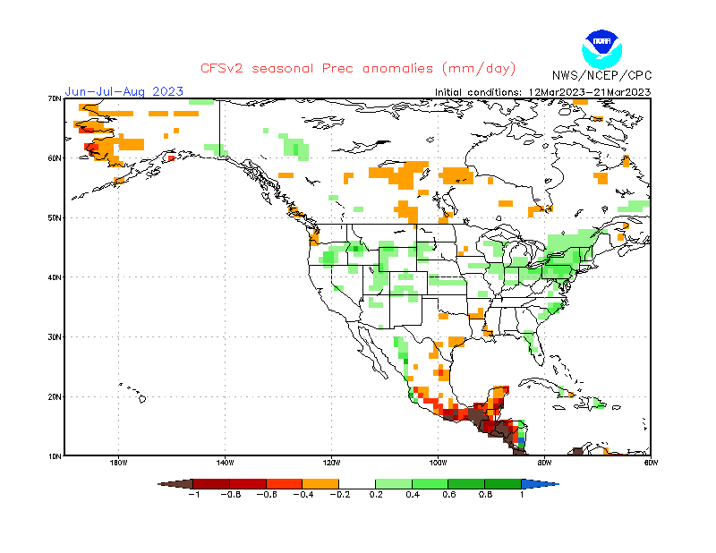
Like the ECMWF, this model also doesn’t show strong drought conditions in the United States. However, this is unlike last year, as models showed strong drought conditions across the central United States.
SUMMER 2023 NOAA EARLY OUTLOOK FORECAST
The NOAA official Summer temperature outlook shows that most of the United States is expected to be warmer than normal. The core warm anomalies are so far focused on the southwestern parts of the United States and the far east.
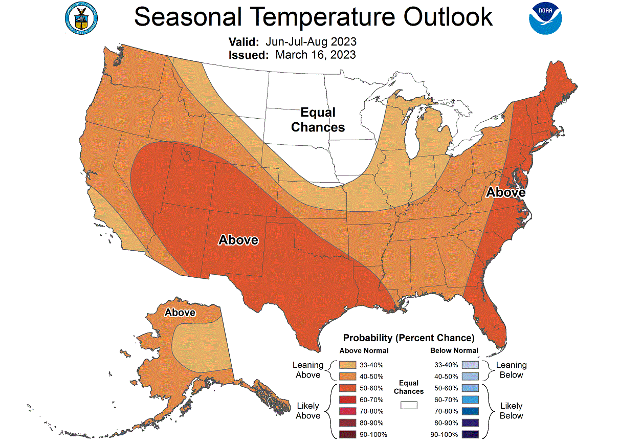
You can see that an area of normal temperatures covers the upper Midwest, creating a gap down to the southeast. The models we looked at show a gap over the western United States, but the interesting thing is that it also exists in the official outlook.
But this is a first-look forecast, so, normally, we see somewhat of a divide between various forecasts.
But the official Summer precipitation forecast is quite similar to the model forecast. We see an equal-to-higher probability for more precipitation over the eastern United States. The models were focused more on the northeast, but the idea is there.
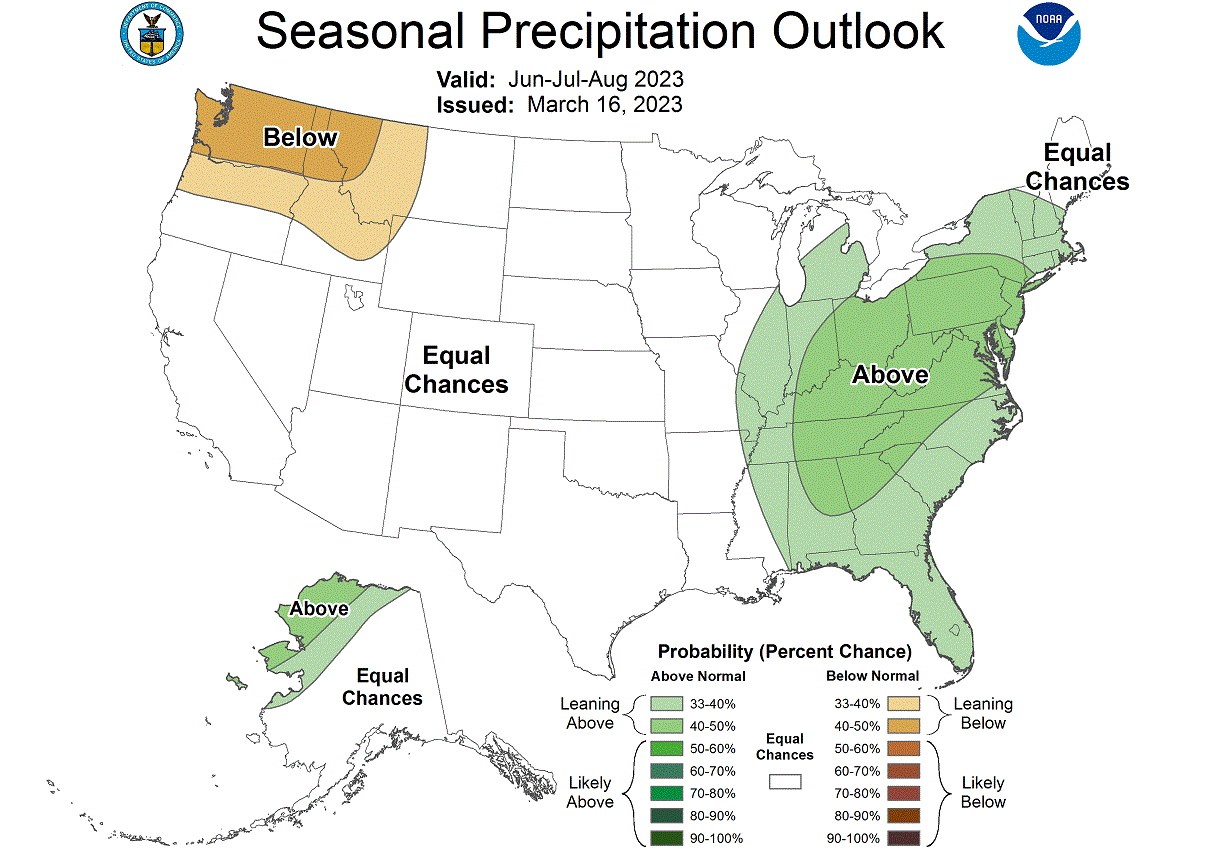
Both models also had a slight tendency for drier conditions over the Pacific Northwest, so this is also a similar idea. But the agreement is smaller than for the high precipitation over the northeast, which is a more high-confidence scenario at present.
We will release regular updates as fresh forecasts and data are available. So make sure to bookmark our page. Also, if you have seen this article in the Google App (Discover) feed, click the like button (♥) there to see more of our forecasts and our latest articles on weather and nature in general.
SEE ALSO: