The meteorological winter is nearly over. A new season, spring, is starting. Just like we did for winter, we will also take a final look at the spring 2020 model forecasts and the expected weather patterns. For good measure, and because people seem to like these simplified overview articles, we will add a sneak peek at the summer 2020 first look trends.
If you are interested in the theory behind long-range forecasts, check out our first post from September 2019, where we had a look at early forecasts for this winter and we also briefly explain the theory behind the long-range forecasts.
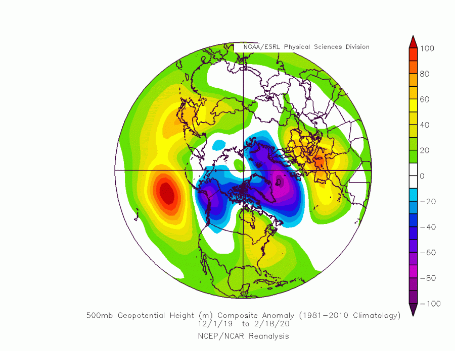
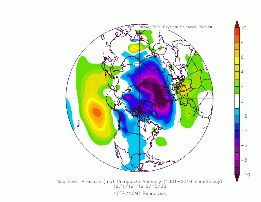
First, let’s take a look at the winter season since it is nearing its end. Looking at the pressure anomalies, it is quite similar to what the long-range forecasts indicated. The North Atlantic was dominated by lower pressure, while Europe, parts of Asia and parts of the United States were under higher geopotential heights. The same goes for Canada, where we see higher pressure in the eastern parts and lower in the western parts. This higher pressure over the east Canadian sector, kinda shows how the main bulk of the lower pressure dominance in the North Atlantic was slightly more eastward based, as we can also see by the lower pressure extending eastward into Scandinavia. The graphics show the winter period from December 1st to February 18th. The last days of February were a continuation of this pattern, especially in the North Atlantic, so the picture will not change much or at all by the end of February when it updates.
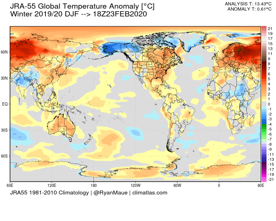
Temperature wise, the winter period was warmer than normal across the hemisphere. We see the whole Eurasian sector being well above average, also most of the continental United States. What stands out is Alaska and the western Canadian sector, recording the most below normal temperatures this winter. And the temperatures there really were substantially below the norm, enough to leave a well defined strong negative signal in the analysis. We have to add that there were a few cold air outbreaks into central and eastern United States, but it was not enough to alter the seasonal average since these outbreaks do not last more than a day or two in one spot. Looking more globally, Australia also stands out as a hotspot, where they were struggling with severe heat, drought, and wildfires during summer on the Southern Hemisphere.
SPRING 2020
For the spring outlooks, we decided to focus on 4 international models, from Europe, the USA, and Japan. Graphics are from the Copernicus Climate EU project. All these forecasts are an average picture over the 3 spring months (March-April-May) and show the general prevailing weather pattern. Even if the models would be completely accurate, it does not mean that such weather conditions would last for 3 months straight. So the models don’t suggest what the weather will be like for the entire 3-month period, but just how it might look 40-60% of the time. Spring is a transitional season when we go from winter circulation to summer circulation. This means that there can be a lot of variance inside the 3-month average, as the season connects the cold and warm ends of the year, and is generally harder to interpret from model maps than winter, as a lot can be hidden or washed out in the average.
ECMWF
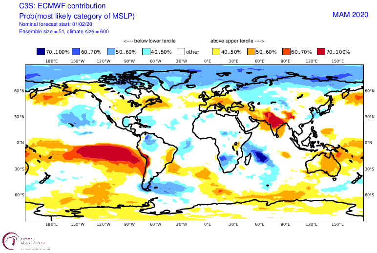
In long-range forecasting, a lot of emphasis is always put on the pressure forecast. That is very important since that tells us a lot about the overall global circulation and weather patterns.
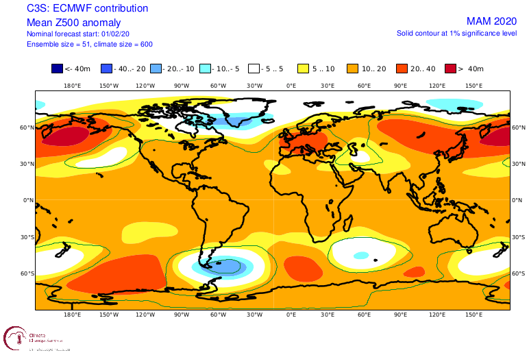
ECMWF is forecasting a similar weather pattern as we have seen this winter. We generally see lower pressure over the pole and in the North Atlantic, corresponding to a positive AO (Arctic Oscillation) and NAO (North Atlantic Oscillation) pattern. We see prevailing high pressure over the North Pacific, central North Atlantic, and Europe. Considering the ridging over North Pacific, that looks like a negative EPO pattern. On the chart, we see a neutral geopotential height zone below the ridging in the North Pacific, perhaps a hint on a Rex-block type pattern. That is indicative of a low-pressure system in the eastern Pacific, north of Hawaii. If this were the case, it could support ridge building over the west USA, meaning that the western United States will be warmer, while the central United States could see more normal to below normal temperatures on average. It is perhaps an important indication for the tornado season, but more about that in a future monthly update. Also, a notable feature is the ridging and high pressure over Europe, which does seem to reach further north. That north expansion is somewhat normal, since the polar front and the jet stream usually slowly retreat back up towards north during spring.
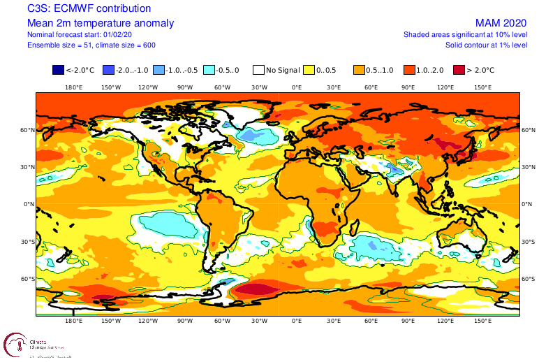
The temperature forecast is reflective of the pressure patterns, with mainly North Atlantic being below normal, due to fairly constant cyclonic activity, that is mixing the ocean surface, allowing the cooler deeper water to mix to the surface. There are also other, more large-scale factors in play, that cool the North Atlantic ocean, but more on that in a future article. Most of Eurasia is projected above normal, while North America is a bit more mixed. Western parts are featuring above normal temperatures, due to the indication of ridging there, plus a lower pressure zone in the eastern Pacific. As a result, we see the neutral temperature zone in the central USA, which would correspond to west USA ridging, as that supports cooler northerly flow. In east/southeast USA, that would mean a warmer response, as we can see. East Canada is indicated as normal since there is a chance of some northerly flow from the cyclogenesis over the Greenland sector. In the South Hemisphere, we have north Australia and South Africa standing out with quite above normal temperatures. While there is spring in the Northern hemisphere, there is autumn/fall on the Southern Hemisphere.
Looking at rainfall, we see south and southeast parts of the USA to be under higher than average precipitation, which would mean lower pressure over the central parts of the continent since that would promote more humid and warmer southerly flow from the Gulf of Mexico.
In Europe, we have some drier weather indication over the southern and western parts, which corresponds to higher than usual pressure. Mainland Europe is seen to be around average to drier precipitation values, so no serious drought conditions are expected, but that remains a possibility if the high-pressure area would be persistent, as 10-20 day dry episodes can be masked in 3-month averages. Lower pressure in the Atlantic does bring humidity into northern Europe, with the prevailing westerly winds from the Atlantic. UK and also Ireland are likely getting some relief from heavy rain and flooding, as the main “storm train” retreats north with the jet stream, as can be seen on the precipitation forecast.
UKMO
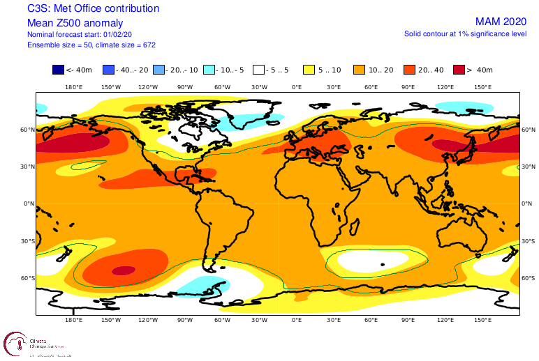
GLOSEA-5 is a model from the United Kingdom Met Office (UKMO). It continues in a very similar way as the ECMWF. It also has a very similarly defined positive AO/NAO pattern, with lower pressure over the North Atlantic and the polar regions. It also has a strong North Pacific blocking pattern but is not very well defined with lower pressure in the eastern Pacific like the ECMWF. It shows the same high ridging over Europe like the ECMWF. The difference with ECMWF is perhaps over North America, as the UKMO tends to extend the lower geopotential heights further west and south a bit into east/southeast Canada. We will see how this influences the weather, on the temperature anomaly forecast.
We still have high positive anomalies over Eurasia, as a natural response to positive AO/NAO, due to lower pressure over the pole. But we do see neutral (or none) temperature anomaly suggested over the eastern United States and southeast Canada, which is likely linked to the low pressure from the North Atlantic/Greenland area extending into eastern Canada. This neutral area means normal temperatures. But we all know that the spring “norm” is also made out of cold air, as winter takes time to slowly filters out of the everyday weather. In this case, it means that in UKMO, cold air intrusions are likely into Canada and the north/east USA, Lower pressure over east Canada promotes occasional northerly flow into these regions, which is nicely reflected on the temperature forecast.
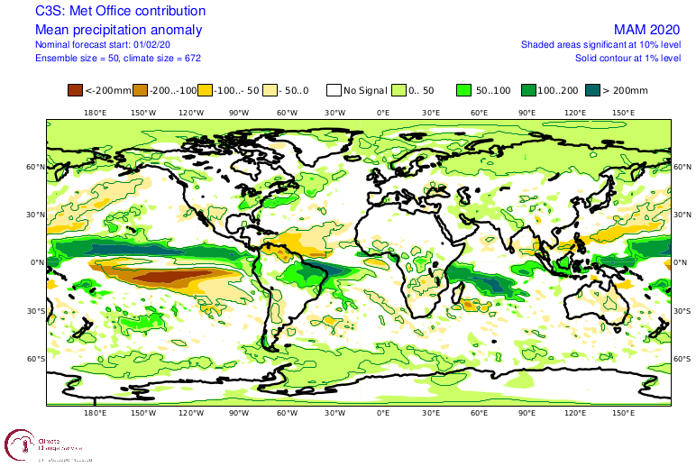
Looking at rainfall, we also see that UKMO does not show drier than normal conditions over Europe, except for the southeast parts. It stays mainly around average, hinting at some local positive anomalies. Just like in the ECMWF, we see precipitation anomalies further north, as the jet stream retreats back north, during its winter-summer transition. In the USA, we have above-normal precipitation in eastern parts, and also in southeast Canada, corresponding to the low-pressure Extention into eastern Canada and parts of north/central USA. Southwest parts are under drier than normal conditions, being dominated by ridging.
NCEP
NCEP is the National Center for Environmental Prediction. They use the CFSv2 model for their long-range forecasts. CFS has a dominant low-pressure area over North Atlantic, focused on the Iceland and south Greenland area. It keeps the jet stream quite more to the south than ECMWF for example. This is a pretty well defined positive NAO pattern.
With such pressure anomalies, its not a surprise that the CFS has likely the warmest spring forecast for the Northern Hemisphere. There is not much to add, except that this forecast seems less realistic, especially when we look at the temperature anomaly distribution, or lack thereof.
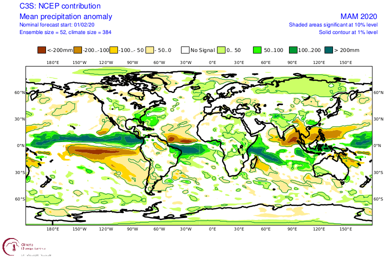
Percipitation forecast from NCEP is a more typical strong positive NAO-ish, with hints of slightly drier conditions over parts of eastern Europe and wetter over northwest Europe and the east/southeast USA.
JAMSTEC – Japan
JAMSTEC is the Japan Agency for Marine-Earth Science and Technology. They use their Sintex-F model to produce long-range forecasts. They do not provide any pressure graphics, so we will be looking at temperature and precipitation only.
We see Eurasia as a whole is again under above-average temperatures. But we have colder than normal conditions in western Canada and central USA. This is indicative of high pressure in North Pacific like we have seen in ECMWF and UKMO.
The precipitation forecast also shows wetter north Europe and the eastern USA, and drier south Europe and the western USA. From this, we can interpret that Jamstec has a pretty well defined positive NAO pattern, perhaps more similar to the CFS than to ECMWF.
SUMMARY
Most forecasts are yet again showing certain lower pressure in the North Atlantic, and higher pressure over the North Pacific and Europe, extending further east. There seems to be a general consensus for above-normal warmth in spring over Europe, with neutral to drier precipitation conditions, more likely in the southern parts, and normal rainfall conditions over NW. In a typical positive NAO pattern in spring, more precipitation is expected in Scandinavia, as the storm systems are tracking further north.
Every year, spring cold air intrusions are always likely into continental Europe, but such forecasts as we see above, do reduce the chance of prolonged cold air outbreaks, as the general circulation pattern is not supportive. During pattern re-adjustments, there are possible windows that colder air can move over the continent, but longer colder episodes of frost are not expected for now. As we go further into spring, the surface temperatures over Europe will slowly become warmer than the Atlantic ocean, where disturbances are mostly coming from. This can create favorable conditions for severe storms over central Europe, mainly in mid to late spring when the temperature differences increase. Despite the jet stream backing up towards north during spring, there are usually still low-pressure systems moving into northwest and west Europe, as the transition from winter to summer during spring is not instant.
North America is a bit more complicated, as it is perhaps a bit more sensitive to the strength/positioning of the low-pressure area in the north/west Atlantic and the East Pacific configuration. The general consensus does seem to be that neutral to perhaps colder than average conditions are possible for parts of eastern Canada, while the weather in the central and eastern United States seems to be more dynamic, with a higher chance of colder spring air intrusions than in Europe, at least in the early spring. This means that there is a possibility for more intense individual severe weather outbreaks during the April-May tornado season, as cold air coming into the central USA meets the volatile warm moist air from the Gulf of Mexico. The main axis of most severe weather greatly depends on the positioning and strength of the high-pressure area in the western USA. If the high pressure is stronger, it can push colder air further east, along with the jet stream, reducing the severe potential as the jet stream support is limited. If the ridge in the west is weak, cold air can drop further west, developing a southerly flow across central and east/central USA, creating favorable severe weather conditions. It is currently impossible to forecast where the severe weather axis will be, based on these 3-month averages. We will issue monthly outlooks along the way, looking at each month in more detail.
As we head deeper into spring, the polar regions start to warm up, which reduces the temperature gradients, and effectively ends the “reign” of the stratospheric polar vortex. This occurs every year. It can happen gradually, or it can happen as a sudden warming event. It is called Final Warming (FW). When we have warming events during winter, the polar vortex usually goes into spring in a weaker state. That means the FW is more gradual and it also does not have any major impact on our weather. But, when the polar vortex is strong, especially like this year, the FW can be rather abrupt or sudden, as it builds up to a certain point to overcome a strong vortex. That means that there is a higher chance for the dynamics to reach down into the troposphere, infiltrating into the general circulation. Since the polar vortex is so strong this year and is forecast to continue on a high note, this will add some uncertainty for the upcoming spring, as the final warming could have an unpredictable influence, affecting the weather patterns even into late spring and even early summer. A lot depends on the timing if it happens early or late in spring. If it happens rather late when the vortex will be already weakened, there is a much lower chance of any meaningful influence. The graphic below shows the stratospheric polar jet stream strength, which is also used as a proxy for estimating the strength and stability of the polar vortex. We can see the polar vortex will stay at above-normal strength, which increases the chances of an influential FW. But its strength will vain over time, and the window for a potential influence from the FW will close eventually.
All the long-range model forecasts above, are model outputs. They should never be taken literally, but only as a guide for the possible development. We look at large scale areas of above-normal/below normal conditions, trying to understand the prevailing circulation and the trending development. We also have to consider, that even if the forecast shows a high-pressure area in this 3-month average, there can still be a few low-pressure systems in the region or a cold front with frost can pass over an area which models forecast as being above normal in temperature. The models are trying to filter out the prevailing weather patterns, but it is our job when interpreting these maps, to also take the normal variance into consideration.
SUMMER 2020
We have received a lot of positive feedback on these long-range model forecast articles, with people mainly praising the explanation simplicity and the “educational/knowledge sharing” approach. So as a token of gratitude for your positive feedback, we decided to add a little sneak peek at first model trends for Summer 2020. We will add only temperature and precipitation maps, as that is the main focus at this range.
Temperature
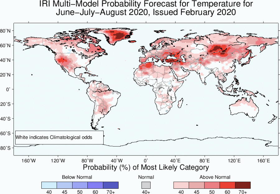
We will not do a model-by-model breakdown as this is very long-range, so we will look at the temperature trends in total. Apart from Jamstec, the other two forecasts are not usually featured in our articles, but they might make a more regular appearance in the future.
At first glance, there is not much similarity between the forecasts, as is to be expected, since this is quite far out, and the predictability skill is low. But we have some common points, namely a “hotspot” in central and east Asia, and an agreement on the above-normal temperatures over the western United States. Interestingly, both the NMME and IRI show near-normal temperatures over the eastern half of the United States and south/central Canada, which might indicate that there is a lower chance of prolonged severe heat waves in these parts. They all agree on the above normal temperature over Europe, but with different distributions. Jamstec even has colder than normal summer over Scandinavia and northeast Europe, which is likely a result from a high-pressure system/blocking over mainland Europe, circulating cooler polar air into Scandinavia from the northwest.
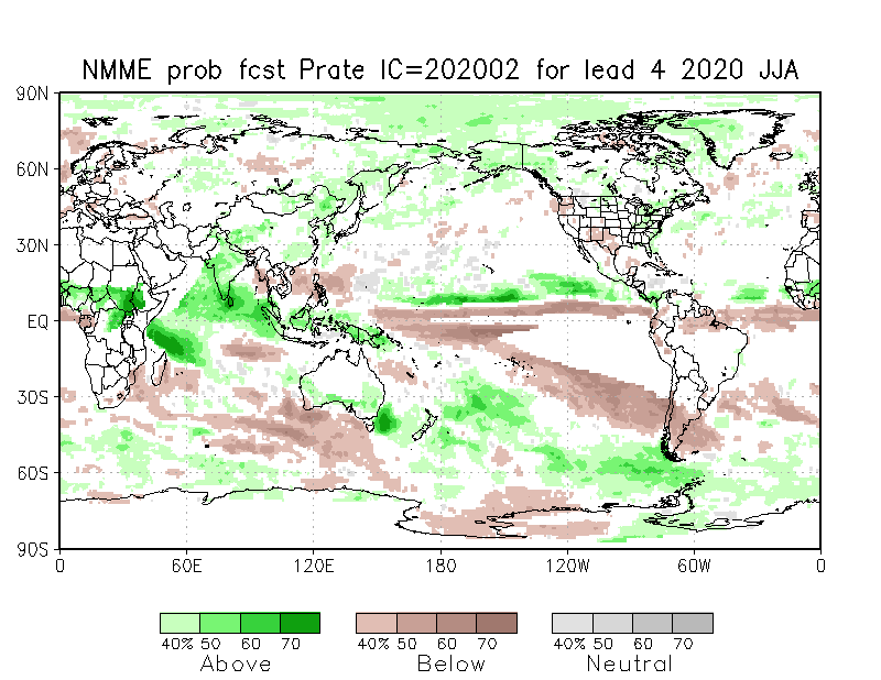
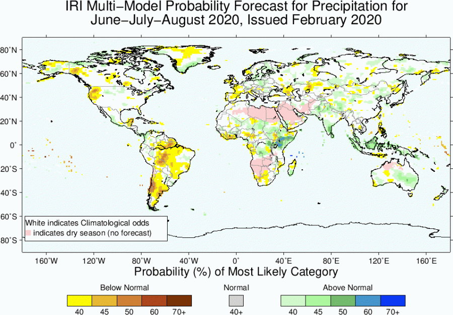
Precipitation
Looking at precipitation, we perhaps have a little bit more agreement, as there is a tendency for drier summer over the western United States, where we observed a warmer summer trend. We can also see the tendency for drier mainland Europe, especially in Jamstec, which is really dry, which further proves the presence of a high-pressure blocking system in the model. Parts of central and eastern United States are indicated as having above-normal precipitation, which explains the lower probability for extreme and long heatwaves, as the models go for a more dynamical pattern in this region.
We will keep you updated on any important further development via individual monthly forecast articles, looking at each month in more detail at its beginning. In the meantime, don’t miss our article on the unusually strong polar vortex, and how it went cold enough to start destroying the ozone layer over the North Pole:
