Meteorological Fall begins in September. But large scale factors are already at work in mid to late Summer that have an impact on the coming seasons. Looking ahead, we can already see La Nina’s influence building for the Fall weather patterns over the Northern Hemisphere, especially North America, which will continue into the Winter 2022/2023.
The meteorological Fall covers three months, from September to November. This is the transition season from the warmest part of the year to the coldest part of the year. So, for this reason, it can be quite dynamic.
Again, an important player for Fall weather this year will be the La Nina, with a known history of its Autumn impacts. So before going into the forecast, we will quickly look at how La Nina works and what its history of impacts can show us for the future.
OCEANS AND THE ATMOSPHERE
La Nina is a cold phase of the large and powerful oceanic ENSO oscillation. If you have never heard of this ENSO before, don’t worry. In just a minute, you will learn all the information you need.
To keep it simple, ENSO is short for “El Niño Southern Oscillation.” This is a region of the tropical Pacific Ocean, which shifts between cold and warm phases. The tropical trade winds (winds that circle the Earth near the equator) usually initiate or stop a certain phase, as they mix the ocean surface and can change the ocean currents.
The image below from NOAA Climate shows the typical circulation during a negative ENSO event (La Nina). Air is descending in the eastern Pacific, creating stable and dry weather conditions, while rising air in the western Pacific causes frequent thunderstorms and plenty of rainfall.
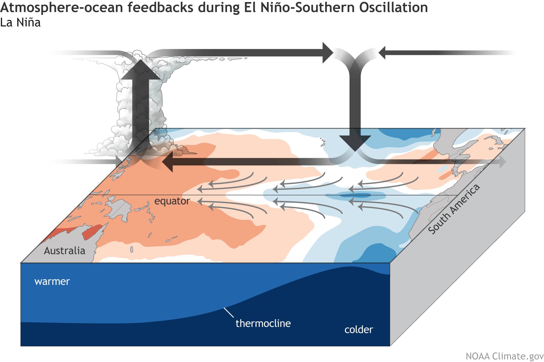
This way, ENSO has a major impact on the tropical rainfall and pressure patterns, impacting the very delicate ocean-atmosphere weather system. This ocean-atmosphere interaction system distributes the ENSO influence globally over our weather seasons.
We usually observe a global change in pressure patterns during the emergence and duration of an ENSO phase. Each phase has a unique impact on the tropics and, with some delay, also on our weather.
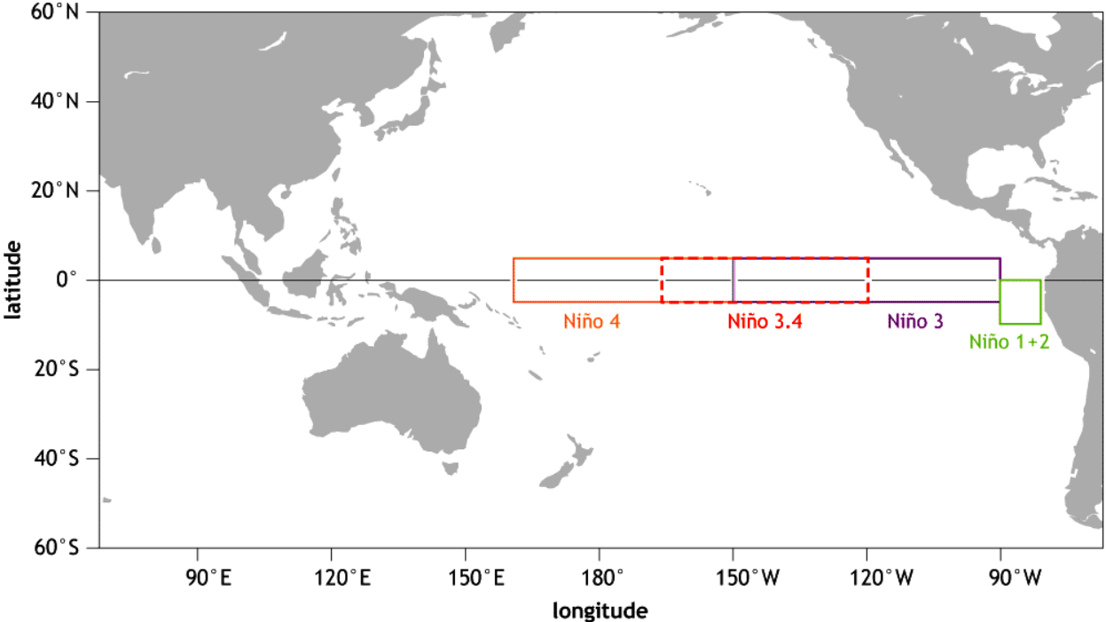
The image below shows all the ENSO regions. The main regions are 3 and 4, and together they cover a large part of the equatorial Pacific. However, most analysis and forecast is based in region 3.4, which is a more central area.
Each ENSO phase has a different influence on the tropical weather and thus has a different impact on the weather worldwide. A specific phase (warm/cold) usually develops around late summer and Autumn and can last until next summer, or even up to two years in some cases.
The cold ENSO phase is called La Nina, and the warm phase is called El Nino. The ENSO phase is determined by the temperature anomalies (warmer/colder) in the ENSO 3.4 region that you saw in the image above.
The image below shows the latest global ocean temperature anomaly analysis. It reveals colder than normal surface waters in the central and western ENSO regions. This basically shows a healthy west-based La Nina, one of the strongest at this time in the past decades.
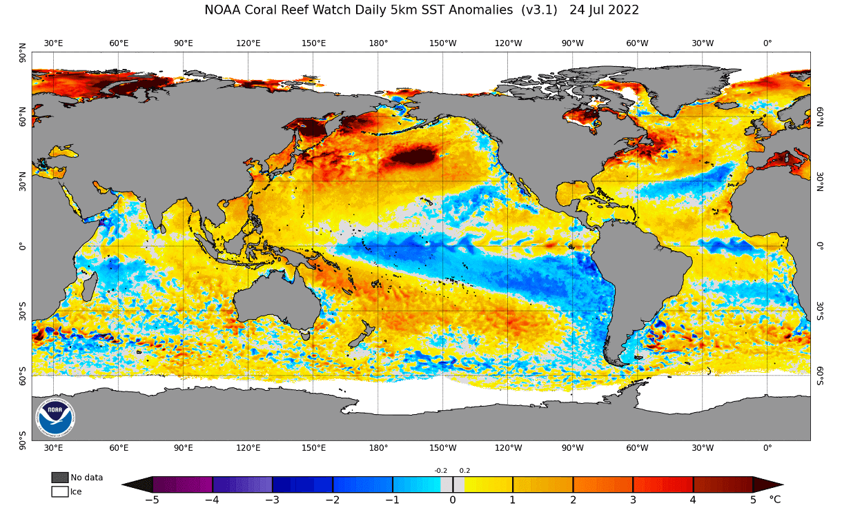
We can also see an unusually strong warm anomaly in the north central Pacific and generally warmer than normal waters in the North Atlantic ocean.
Below we have a zoom-in on the ENSO regions. You can see the cold anomalies having a “wave-like” shape. This is because of the strong easterly trade winds that push the waters towards the west, creating swirls on the ocean surface.

Some of the cold anomalies in the tropical Pacific are continuing from the strong La Nina from last year. It was growing over last Autumn and into Winter, continuing into Spring. The image below shows the temperature progression in the ENSO regions, where you can see the first La Nina phase in 2020/2021 and the new one starting last Autumn.
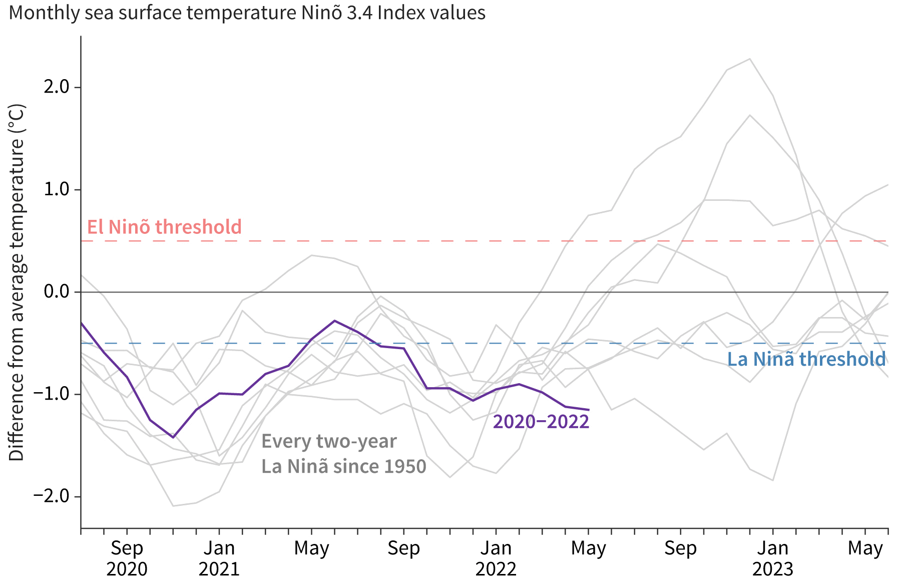
We produced a high-resolution animation showing the ocean temperature anomaly development across the ENSO regions in the Pacific from Winter to Spring 2022. The cold anomalies remained stable, carrying the cold phase into the North Hemispheric warm season.
Since then, we can look at the graph below to see the temperature progression in the western ENSO 4 region. It currently shows some of the strongest cold anomalies for this time of the year in recent history.
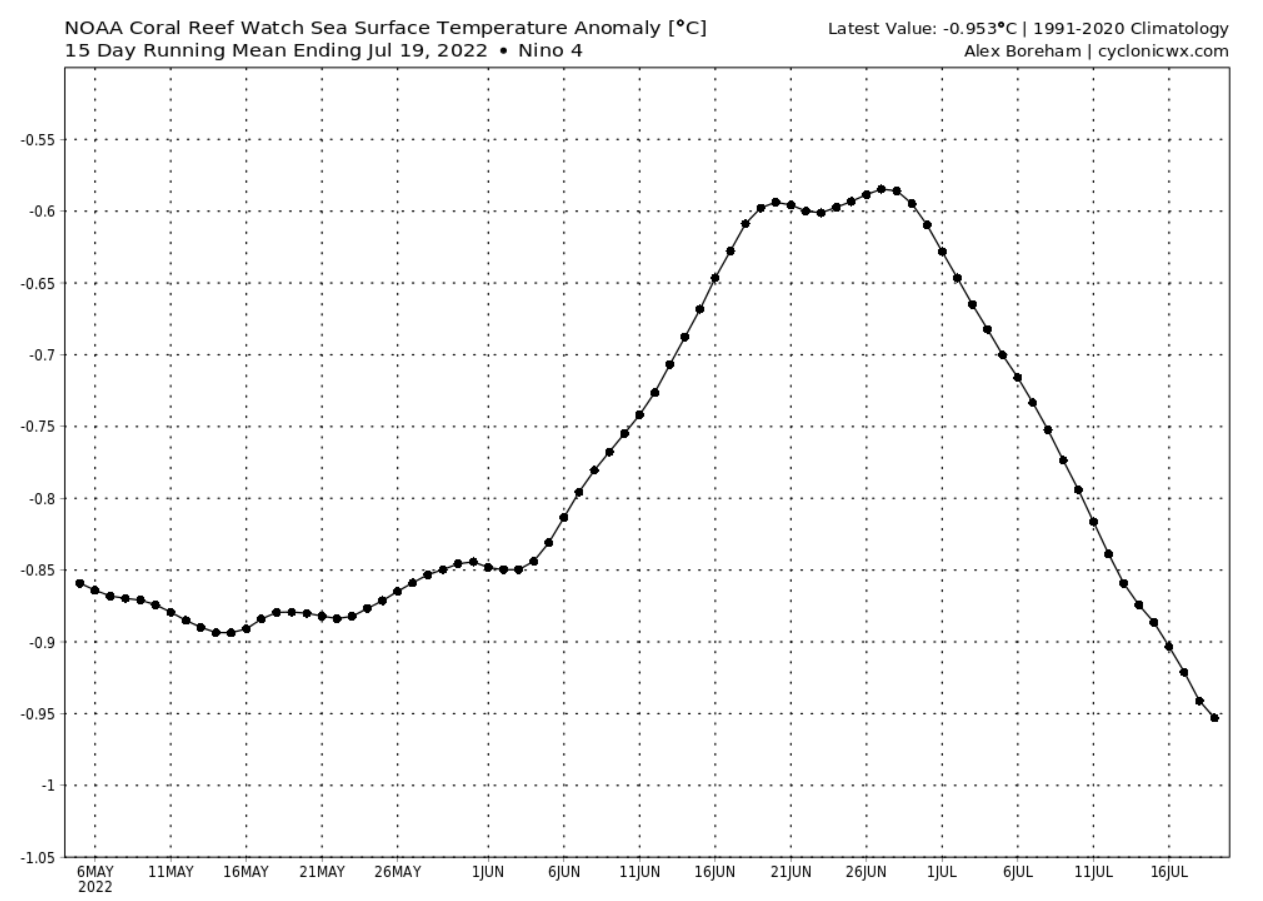
You can see that there was a temporary cooling reduction in early Summer. But we are now in a decent cooling episode again, mainly due to stronger easterly trade winds in this region.
ENSO FALL/WINTER OUTLOOK
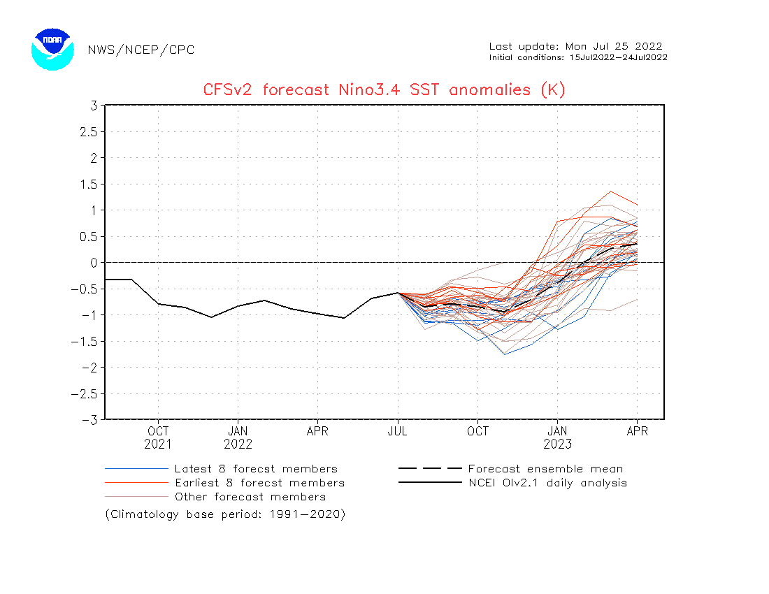
Below we have an analysis/forecast graphic by ECMWF, which shows the forecast of the main ENSO 3.4 region. We can see the continued negative anomalies and cooling into Fall and also Winter 2022/2023. The forecast average is staying within the La Nina phase threshold (-0.5 or colder).
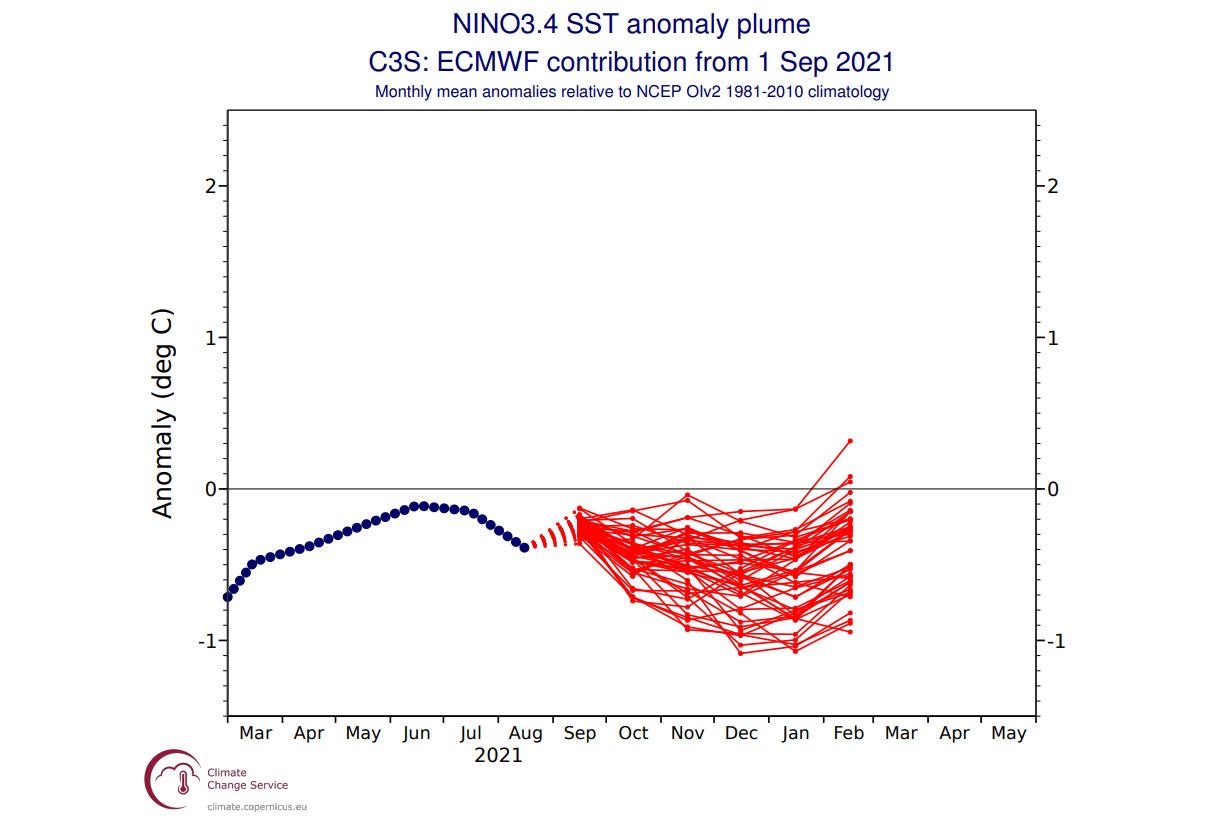
The actual ocean temperature forecast for Fall from ECMWF shows that La Nina is present across the entire equatorial Pacific Ocean. It is not as strong as last year but has a strong presence in the ocean and also in the atmosphere, as we will see in the forecast part of the article.
Another respected ENSO forecast comes from the Australian BOM office. They produced a graph that contains the forecast from several global long-range models. Australian BOM uses a different threshold (+/- 0.8) for the ENSO phases than NOAA (+/- 0.5).
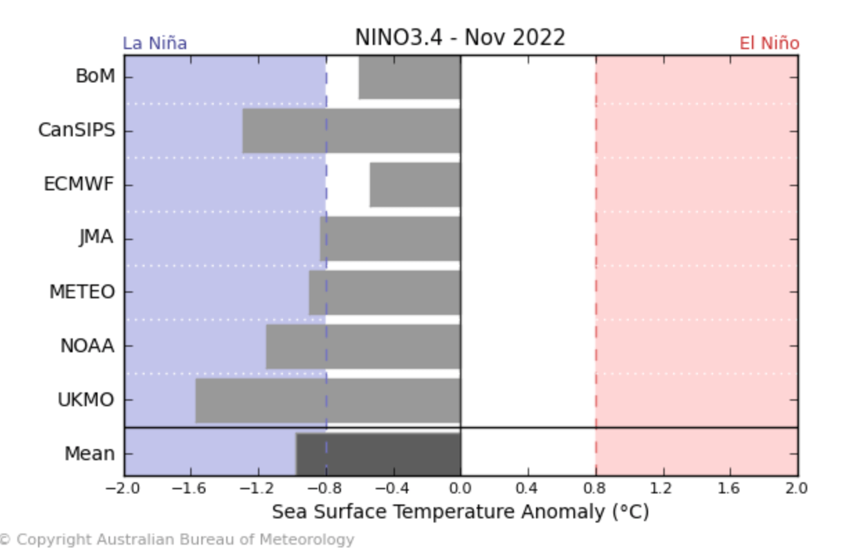
The forecast is centered on November 2022 and shows all models and forecast centers agreeing on the negative phase of the ENSO being active. There are differences in the strength of the La Nina at this period, but the average forecast from all models agrees on an active moderate event.
PAST LA NINA AUTUMN WEATHER PATTERN
There have been several Fall/Winter seasons with an active La Nina phase. Counting last year, there were a total of 10 such seasons in the past 25 years.
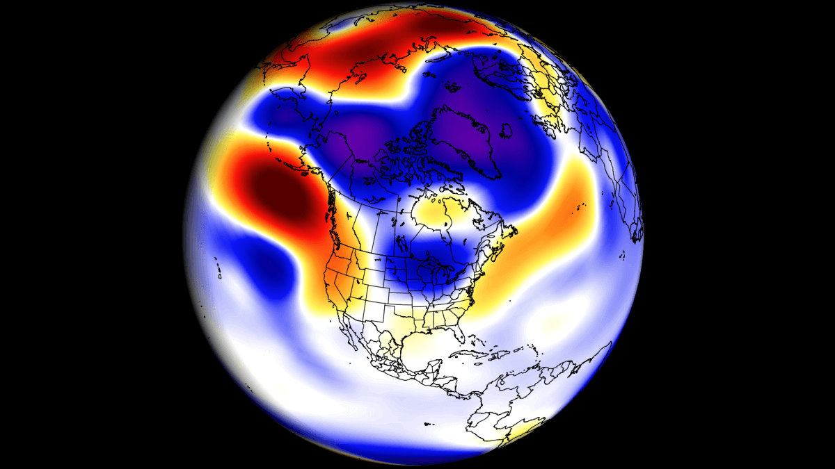
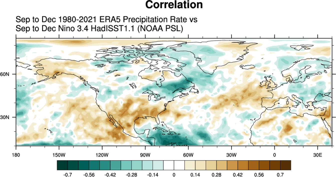
We produced special graphics that show the correlation between the ENSO and global geopotential height in the September-December period. Simplified, it shows the prevailing signal during an active ENSO phase. In this case, the colors represent a La Nina signal.
First, we have the pressure pattern, covering the Autumn and early Winter period. The two features that stand out are the North American pattern and the North Atlantic pressure pattern.
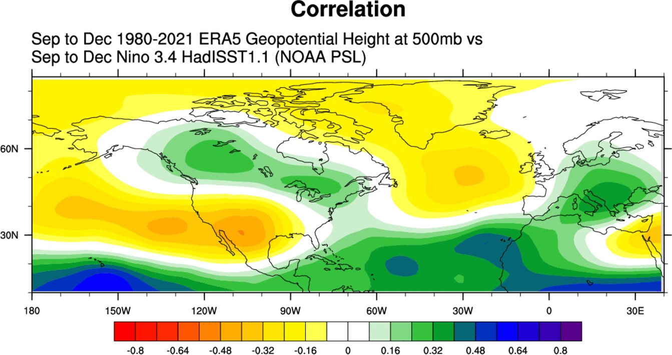
In the North Atlantic, we see a high-pressure system extending from the ocean up north into Greenland. West of it, we have a lower pressure area over Canada and the northeastern United States and a high-pressure system extending from the North Pacific into the southern United States.
Next, we have the temperature patterns. There is no real surprise about the below-normal temperatures over Alaska and parts of Canada. The western United States is warmer, with cooler anomalies over the northeastern and the far northwestern parts of the United States.
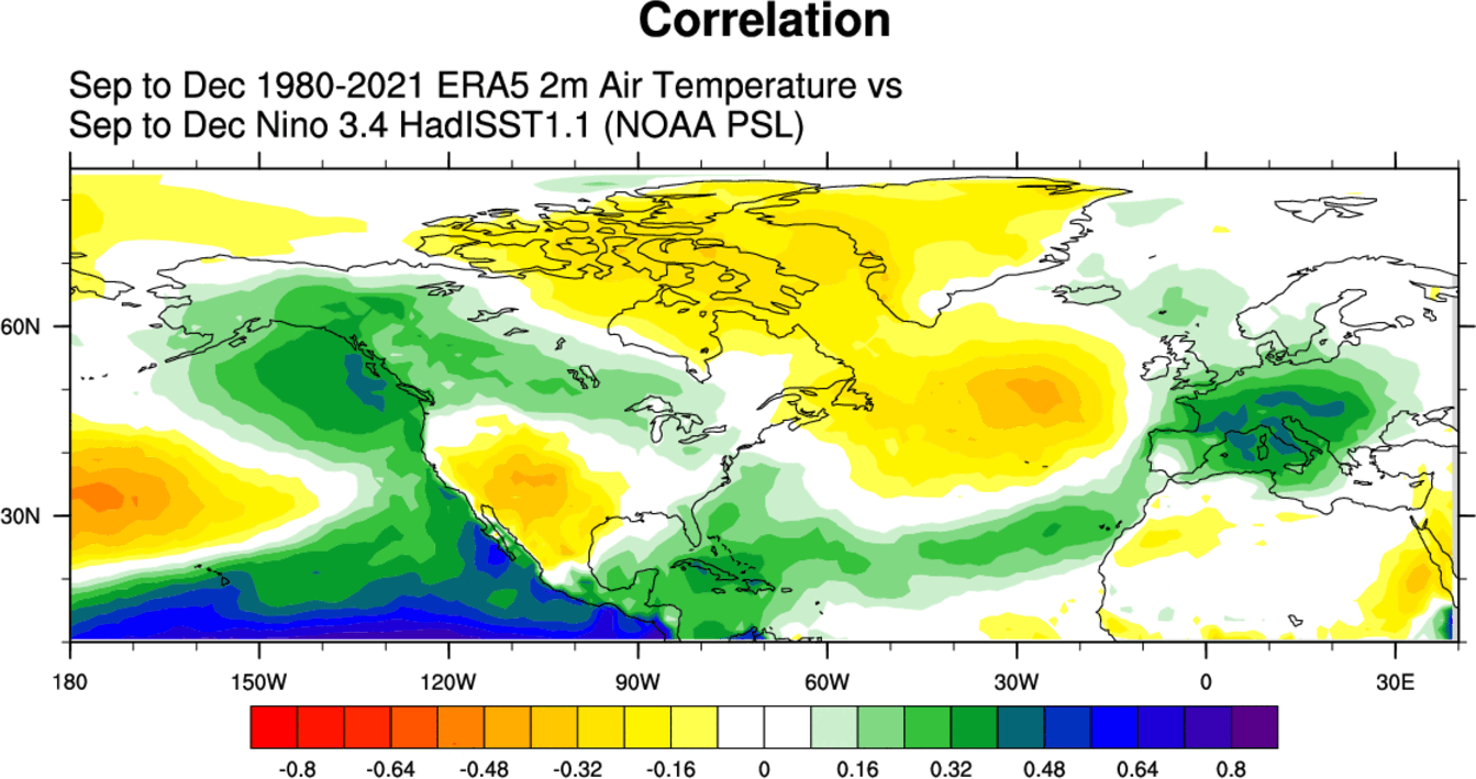
There is a cool signal over most of Europe due to the prevailing northerly flow from the high pressure in the North Atlantic. But we have to add that the weather pattern in this region is not as directly related to the ENSO phases as in the United States and Canada.
Precipitation patterns in a La Nina Fall season are more “dipole” like. We can see a drier than normal pattern over most of the central and southern United States and wetter conditions over the northwestern and far northeastern United States and Canada.
NORTH AMERICA ECMWF REANALYSIS
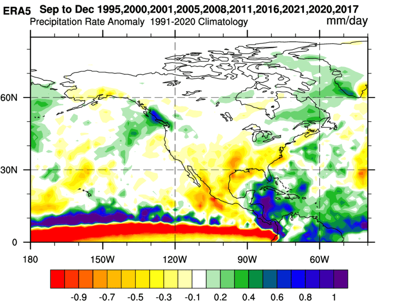
But a more direct ENSO influence can be found in North America. For this reason, we produced special graphics that combine 10 of the last La Nina Fall seasons, showing the average weather patterns during a La Nina Fall season based on actual patterns.
First, we have the pressure anomaly pattern, covering the September-December period. We see three areas of high-pressure anomalies and a low-pressure zone over Alaska and western Canada.
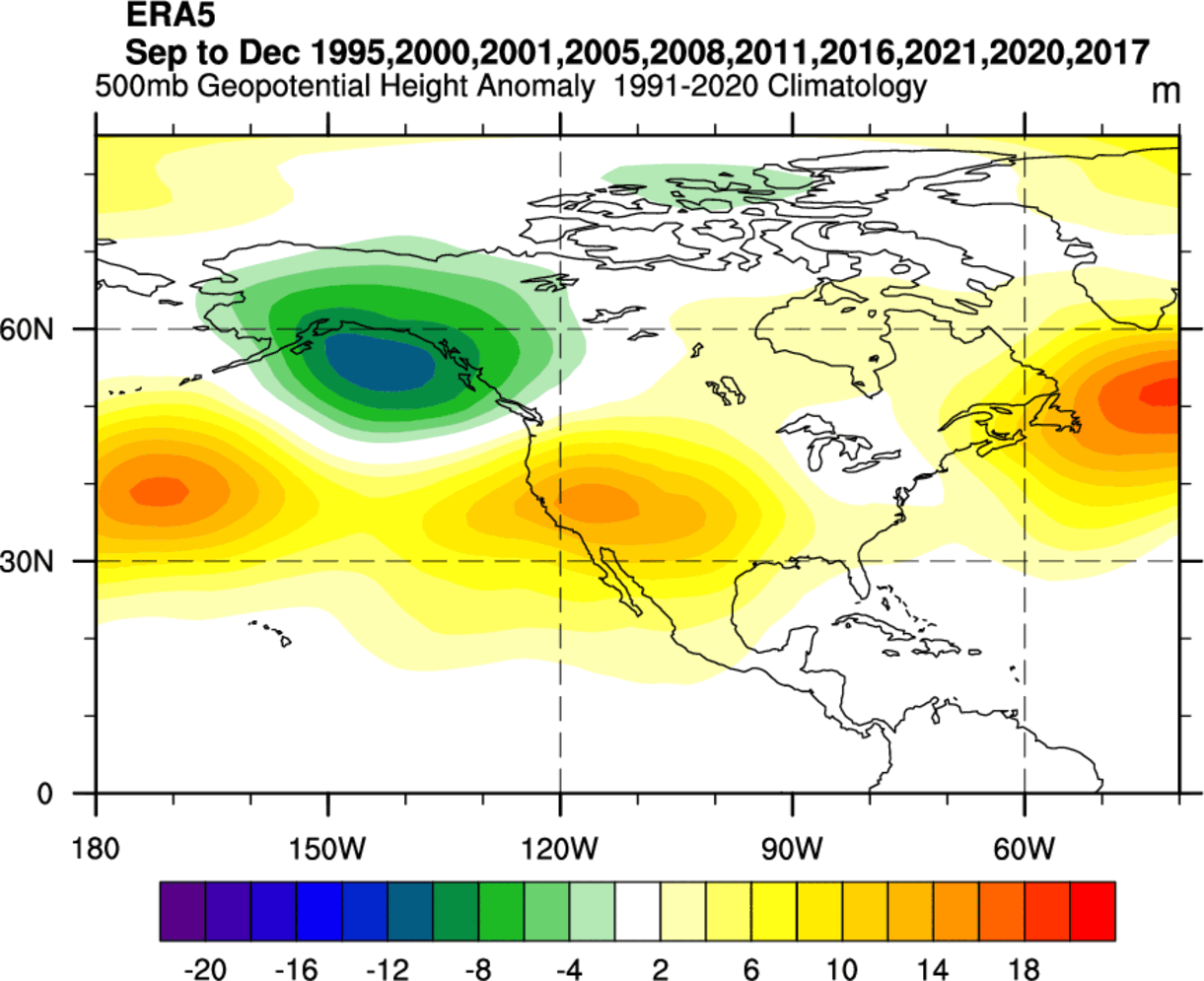
High-pressure anomaly in the North Pacific is more of a classical La Nina signature in all seasons. But in the autumn period, the high-pressure area over the western United States is also seen often. There is also a high-pressure anomaly in the North Atlantic.
Looking at the temperature patterns, we see a negative anomaly present over Alaska and the Pacific Northwest, under the influence of the low-pressure zone. Warmer than normal temperatures are prevalent over western and southern United States and parts of Canada.
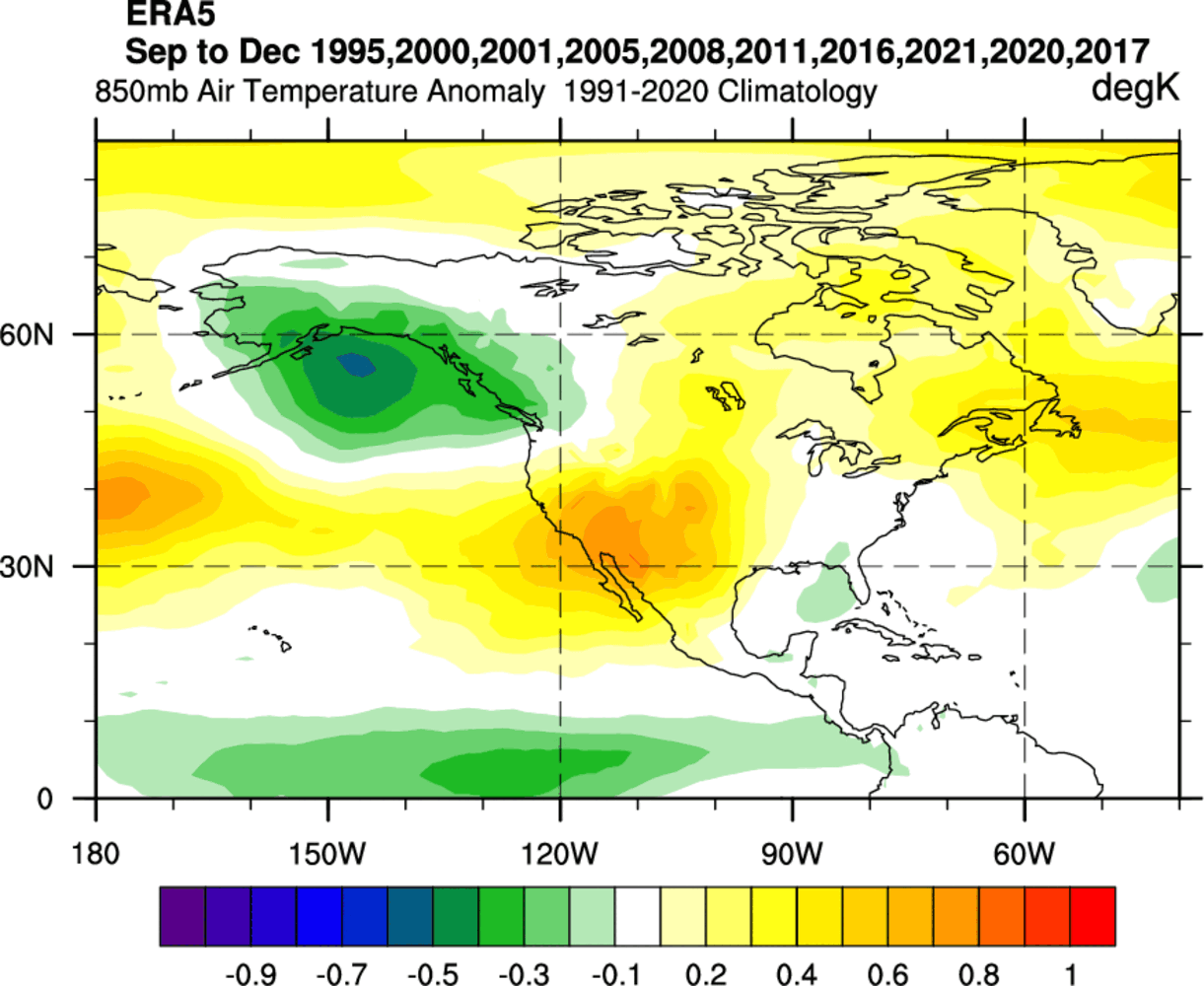
There is a neutral to cooler anomaly present over the southeastern United States. There are indications that some La Nina seasons favor lower than normal temperatures over this part of the country.
In the precipitation patterns, we can see a quite drier than normal situation over most of the southern and central United States. We see more precipitation over the Pacific Northwest and parts of the northeastern United States and eastern Canada.
Knowing what La Nina is and how it can change our weather, we will now look at the actual forecasts to see if we can find its influence in the coming Fall 2022 weather season.
FALL 2022 LONG-RANGE FORECAST
For the Fall 2022 early forecast, we decided to focus on the two main (or most used) seasonal models. The ECMWF model from Europe and the CFSv2 from NOAA/NCEP in the United States. Graphics are from the Copernicus Climate EU project and the CPC/NCEP.
All these forecasts are an average picture over the course of 3 months (September-October-November) and show the general prevailing weather pattern forecast for the meteorological Fall. This only shows/implies how the weather patterns might look 40-60% of the time during the weather season.
ECMWF FALL 2022 FORECAST
The ECMWF model is regarded as one of the most reliable long-range forecast models. Generally, the ECMWF model is at the top of the chart as far as reliability goes. But no long-range/seasonal forecast can ever be deemed “reliable.” We are only looking at trends and how the weather patterns might evolve on a large scale.
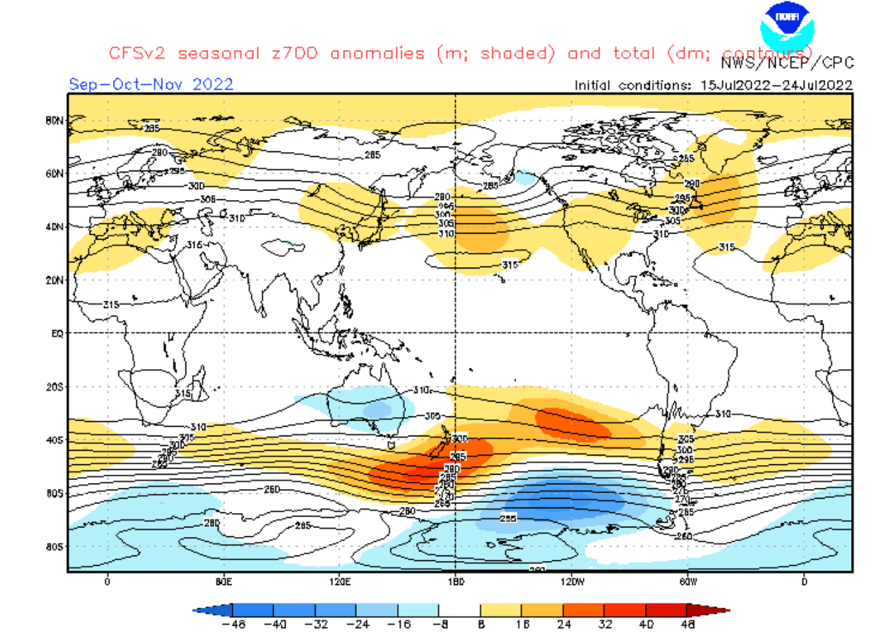
The pressure pattern forecast shows the typical La Nina high-pressure system in the North Pacific, with another high over the western United States and in the North Atlantic. This is almost an identical pattern to the historical analysis we have done above. It also has a low-pressure zone hinted over Alaska and western Canada.
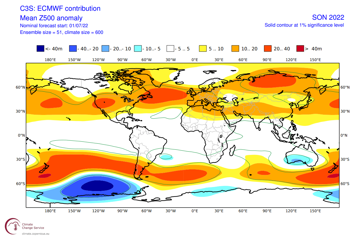
Looking at the European sector, we have a high-pressure zone extending from the Atlantic into Europe. As a response, the low-pressure zone is moved further up to the north.
When we look at the global air temperature anomaly distribution, we can see the warmer western United States and Europe. Northwestern Canada and Alaska are in a neutral zone, which will likely turn cooler in the next updates.
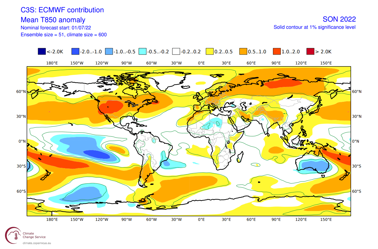
Weaker warm anomalies are hinted across the southeastern United States, as seen in the historical analysis as well. Overall, this seems to be quite a typical La Nina pattern overall, confirming its presence in the circulation.
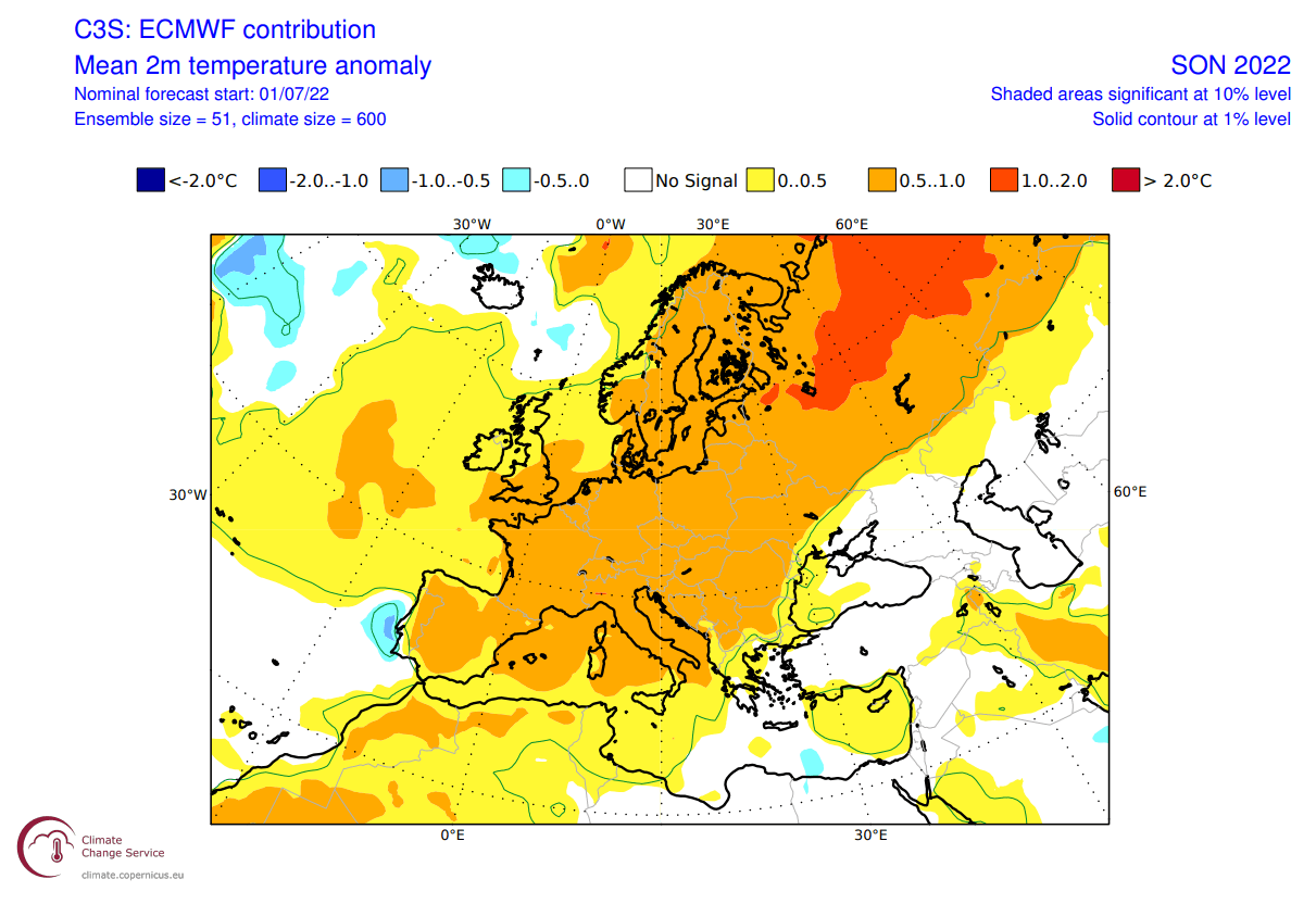
Looking closer at Europe, we can see warmer than normal surface temperatures over much of the continent. This is due to a high-pressure area over the North Atlantic and extending into Europe.
Over North America, we see much warmer temperatures in the western United States under a high-pressure system. Warm anomalies extend into the northeastern United States and eastern Canada. But Alaska and northwestern Canada remain neutral to cool under the influence of the returning polar jet stream.

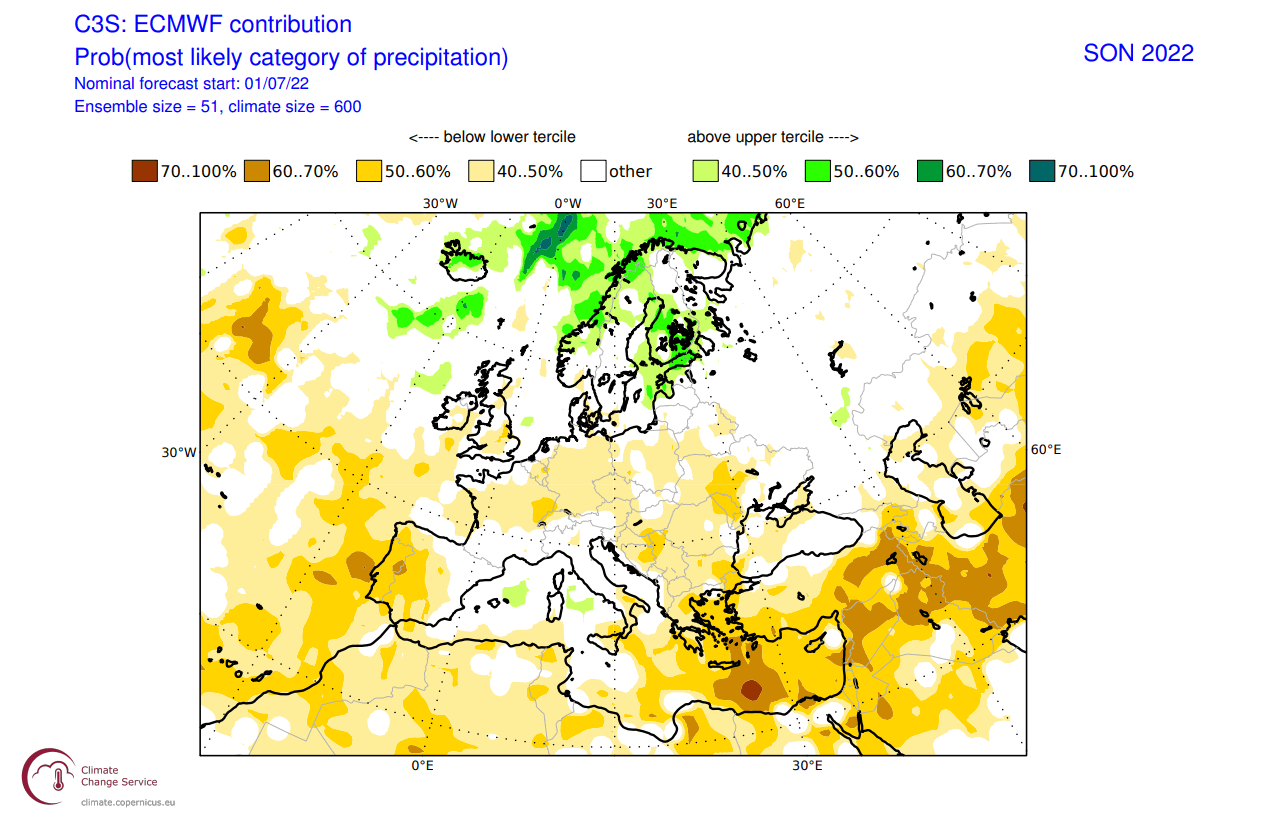
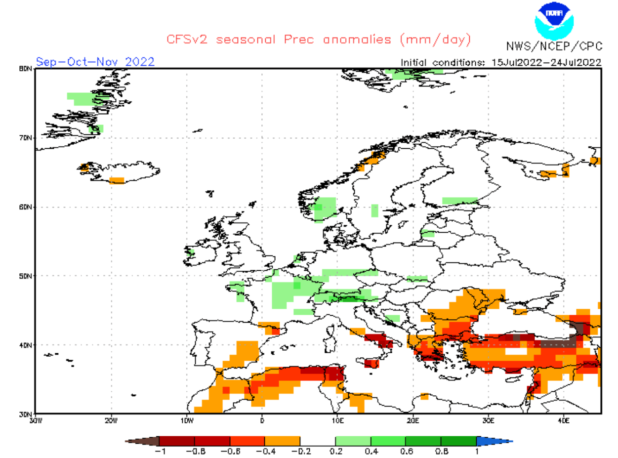
Precipitation-wise, we can see mostly drier conditions over Europe. More precipitation is forecast over northern Europe, under the influence of a low-pressure zone.
Over North America, we have wetter conditions over the northwestern United States, expanding into most of Canada. The Midwest and the southern United States show a dry signal, while we also see more precipitation over the southeast.
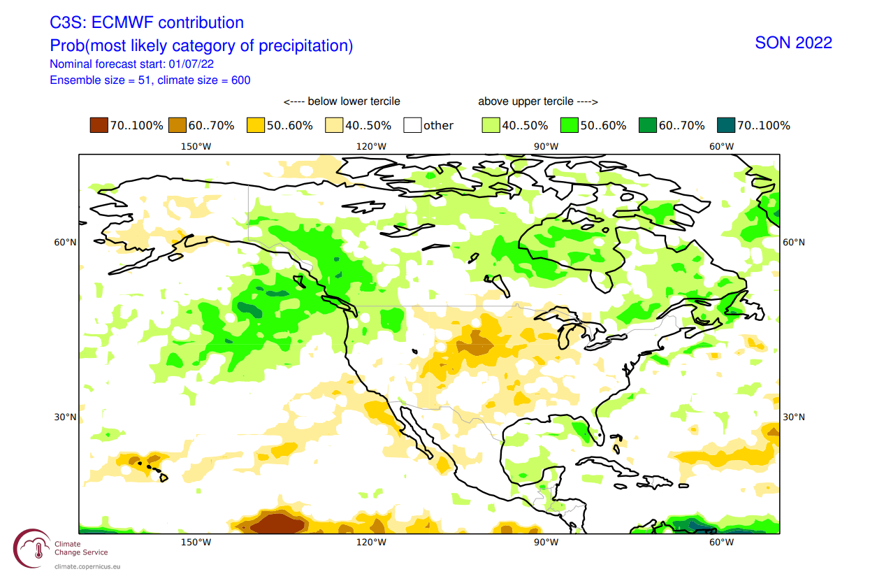
It is interesting to see more precipitation in the Gulf of Mexico and in the western Caribbean. This is part of the tropical systems development region. We can interpret this as a potential signal for more tropical activity in the later part of the Hurricane season.
CFS FALL 2022 FORECAST
As a counter-weight to the ECMWF, we always tend to use the main North American long-range model, the CFS version 2 from the NOAA/NCEP in the United States. We will use the latest forecast update from late July.
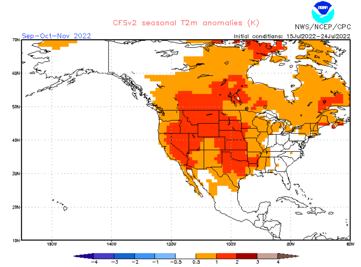
The CFS also has a proper La Nina developing over Autumn and into early Winter. The intensity is similar to the ECMWF forecast, showing a moderate negative ENSO event.
The global pressure pattern has similar features to the ECMWF. High pressure is present over the central North Pacific, North Atlantic, and the western United States. Interestingly, we also have a low-pressure area over western Canada, as in the historical pattern.
Temperature-wise, we have a clear warm signal over much of the western United States. Most of far western Canada and Alaska are forecast as neutral to colder than normal, also hinted by the ECMWF. Warmer anomalies are present over western and southern Europe but not as strong as in the ECMWF forecast.
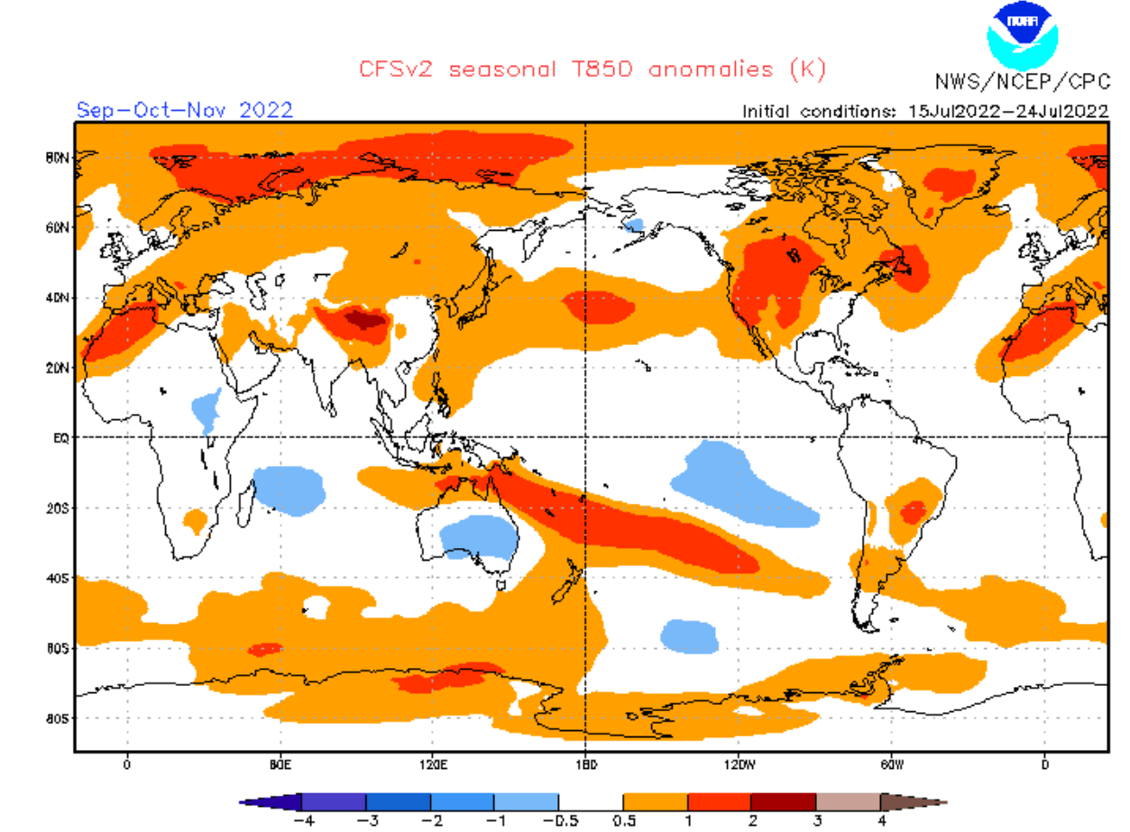
Looking closer at Europe, we see warmer temperatures over much of the continent. Despite a slightly different pressure anomaly over the continent, it still forecasts the same temperature pattern as the ECMWF.

But the pressure difference is more impactful in the precipitation forecast. We see normal to wetter conditions over central, western, and northern Europe. At the same time, we have drier conditions over far southwestern and southeastern Europe.
Temperature anomalies over North America look like a more typical La Nina fall season. Warmth over western and central United States, and a normal zone over the eastern and southeastern United States. We also see most of Alaska and northwestern Canada with normal temperatures under a low-pressure area.
The more westerly flow also means wetter conditions for the Pacific Northwest, thanks to the low-pressure area. Drier conditions prevail over much of the central and eastern half of the United States, influenced by the stable conditions of a high-pressure system.
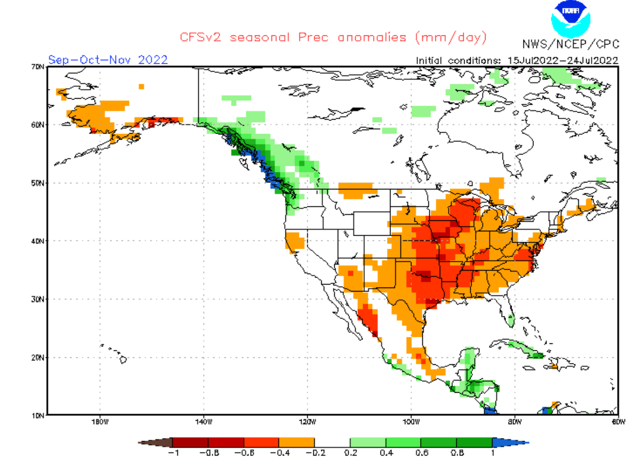
We also see more precipitation around the Gulf of Mexico and in the Caribbean in the CFS forecast. This also hints at potential tropical system development in the second half of the Hurricane season.
FALL 2021 FORECAST SUMMARY
Reading images and descriptions can be confusing sometimes. So to summarize, here is what the model forecasts suggest for the Fall 2022 season:
Europe is expected to have warmer than average temperatures over most of the continent. A high-pressure system is set to prevail in Autumn over much of the continent.
Northern Europe will likely be under the influence of a low-pressure system, while weather over the British Isles will depend on the high pressure in the North Atlantic.
No big precipitation anomalies are expected over the mainland, with the exception of likely drought conditions continuing in Autumn over southern Europe and the Mediterranean. Scandinavia could see more precipitation in the Autumn season.
North America Fall forecast shows a high-pressure area is favored over the western United States and the far northeastern United States. A low-pressure is set to develop over western Canada and Alaska.
Most of the western and southwestern United States can expect to see warmer than normal and drier conditions. But the southeastern United States is expected to see normal with a chance of more precipitation than normal over Florida.
Northern states will likely see warmer temperatures and drier conditions over the Midwest.
Above normal temperatures are also expected over eastern Canada, while western Canada and Alaska should see normal to colder conditions and a higher chance of an earlier winter season.
The La Nina influence is expected to grow later in the season, which means a low-pressure area will be further established over western Canada. This could mean early snowfall is likely for parts of the northwest and the northern United States.
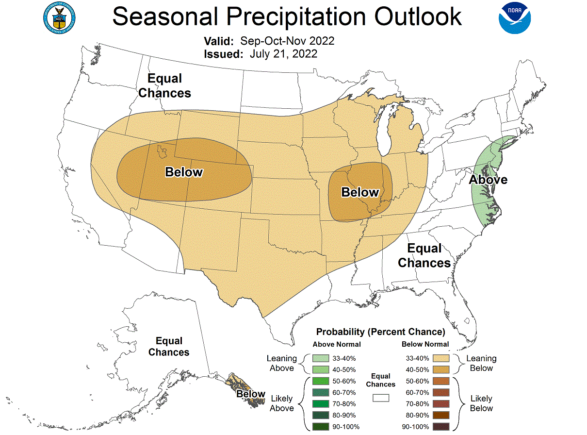
Below is the official Fall 2022 outlook from NOAA/CPC for the United States. Temperature-wise, we see the warm west and far northeast standing out.

We can also see a neutral temperature zone in the Midwest. That does indicate a chance of more cold fronts coming down from the northwestern United States and western Canada towards the central regions. It could mean earlier snowfall than normal in the northern United States.
Precipitation-wise, the NOAA Fall 2022 outlook shows drier conditions in the western and central United States. Wetter conditions are expected mostly on the east coast of the United States.
THE POLAR VORTEX RETURNS
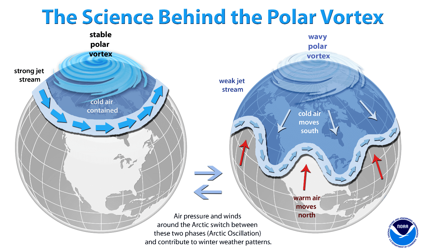
We cannot talk about Fall without also mentioning the Polar Vortex. The Polar Vortex re-emerges every Fall and plays a key role in weather development in late Fall, over the Winter, and into Spring.
The Polar Vortex is a large cyclonic area that is spinning over the entire Northern Hemisphere, from the ground up to the top of the stratosphere, reaching over 50km/31miles in altitude.
We produced a 3-dimensional model of the Polar Vortex, extending from the lower levels up into the stratosphere. The vertical axis is greatly enhanced for better visual purposes. You can see in the image below what the actual structure of the Polar Vortex looks like.
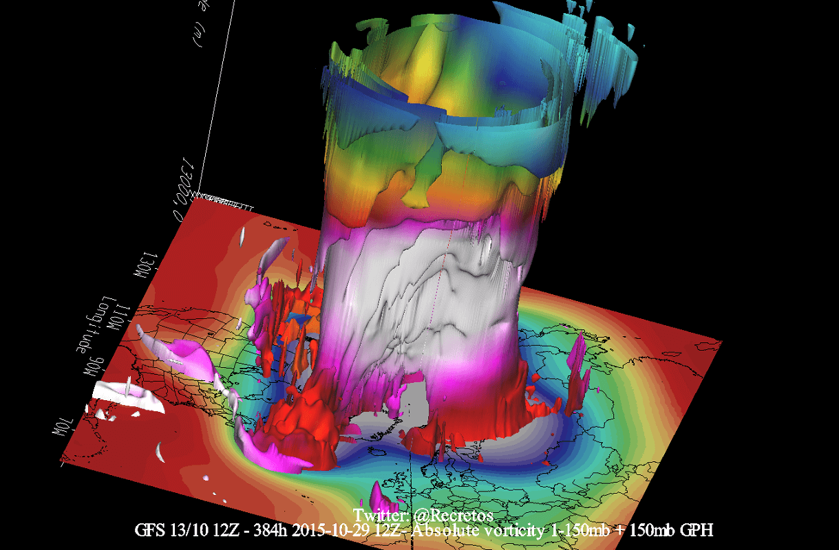
In the example above, the Polar Vortex was undergoing a temporary warming event. These events can disrupt the Polar Vortex, weakening its circulation and changing the weather patterns below.
A strong Polar Vortex usually means strong polar circulation. This usually locks the colder air into the Polar regions, resulting in milder seasonal conditions for most of the United States and Europe.
In contrast, a weak Polar Vortex can create a disrupted jet stream pattern. As a result, it has a harder time containing the cold air, which can now escape from the polar regions into the United States or Europe.
The most recent stratospheric warming event actually occurred a few months ago, in late March. It was strong enough to influence the early Spring pressure patterns over the Northern Hemisphere.
Taking a look at the temperature profile at the 10mb level (30km/18.5mi), we can see a warming wave developing over eastern Siberia in late March. Here we can also see the separation of the core into two separate entities, as a stratospheric high-pressure system was pushing in from the North Pacific.

The image below shows the vertical pressure anomaly from the surface up into the upper stratosphere over the North Pole. It gives us a better idea of the pressure anomalies changing with time and altitude. The red square marks the polar vortex collapse event.
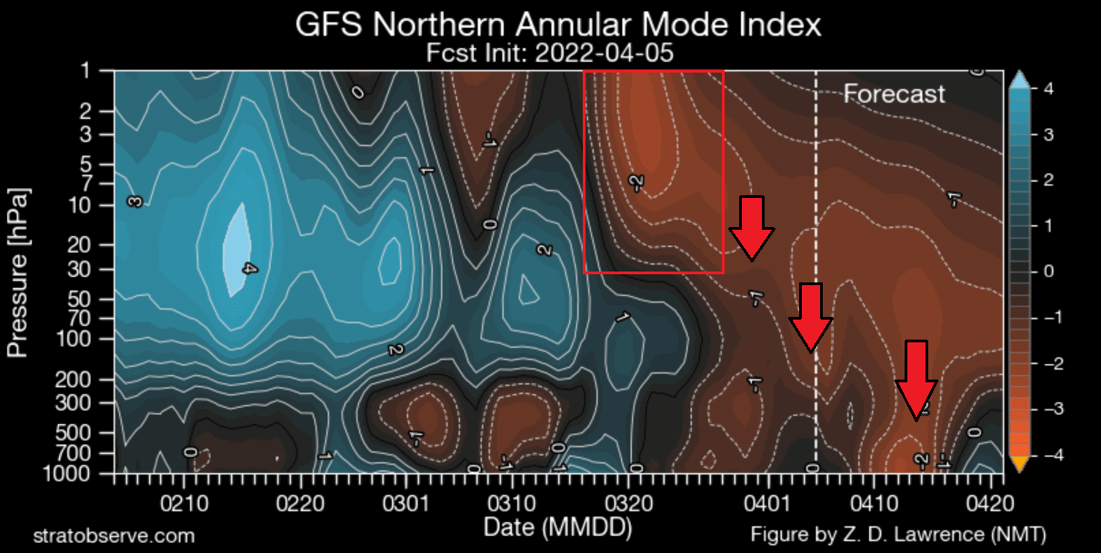
We can see by the arrows that the high-pressure anomaly resulting from the warming event was propagating down. It then connected down to the weather patterns, most strongly in late March and early April.
Looking now finally at the forecast for the upcoming seasons, we have an interesting picture. The ECMWF forecast for the 10mb stratospheric zonal winds shows a reduction in the power of the stratospheric winds in late Fall and early Winter.
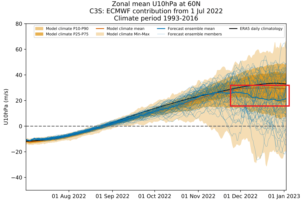
As winds are directly related to the strength of the Polar Vortex, we can see this as a signal for a weakening of the Polar Vortex. This would imply a more disrupted pattern and a chance of high-latitude blocking, thus more cold air in the United States and Europe.
It gives us a signal to keep an eye on, as these dynamics can have a large-scale and long-lasting impact on the weather pattern during Winter.
We will keep you updated on the global weather pattern development for the coming seasons, so make sure to bookmark our page. Also, if you have seen this article in the Google App (Discover) feed, click the like button (♥) there to see more of our forecasts and our latest articles on weather and nature in general.
SEE ALSO:
A record-large wildfire in Slovenia spreads fast under a new Heatwave event over Europe