The El Niño is growing in the Pacific Ocean and is expected to have a noticeable influence on the Fall weather season across North America and partially Europe. The El Niño influence is expected to continue into Winter 2023/24, changing the jet stream patterns over the Northern Hemisphere.
When looking at weather seasons and long-range forecasts, we must understand that large and small-scale drivers are behind their evolution.
Seasonal forecasting focuses on large-scale pressure systems and jet stream positioning. Over the Northern Hemisphere, this upcoming Fall season will be under the El Niño influence, with a different jet stream positioning than the previous years and a different weather development across the United States, Canada, and Europe.
HOW THE OCEAN MEETS THE ATMOSPHERE
El Niño is a phase of the ENSO, which stands for “El Niño Southern Oscillation.” This region of the equatorial Pacific Ocean experiences regular shifts between warm and cold phases. Typically there is a phase change around every 1-3 years.
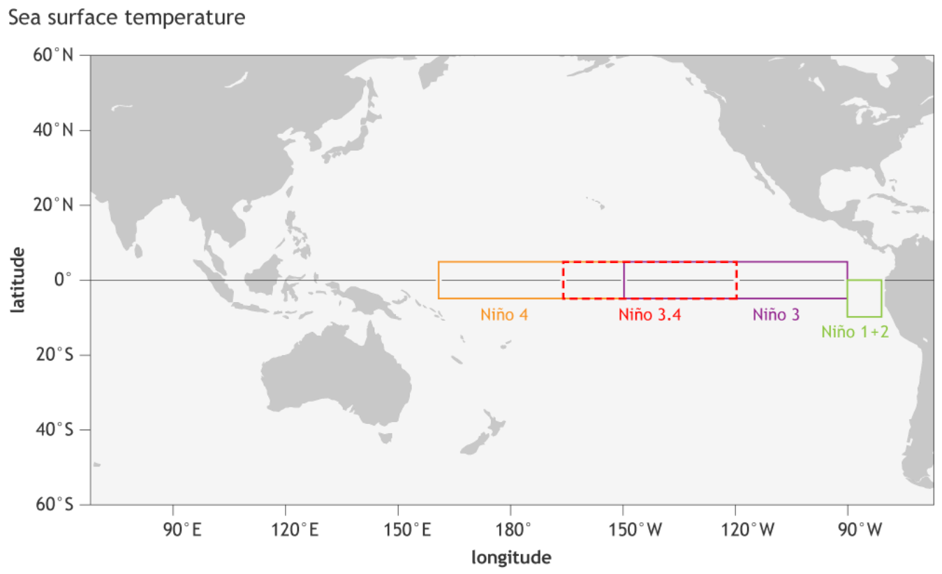
The image below shows the ENSO regions across the tropical Pacific. Regions 3 and 4 expand over the east and west tropical Pacific. The main area that defines the ENSO phase combines regions 3 and 4, seen in the image as the Nino 3.4 region.
Each ENSO phase influences the pressure and weather in the tropics differently. This affects the overall global circulation over time, changing the weather patterns worldwide. The cold ENSO phase is called La Niña, and the warm phase is called El Niño.
A (cold/warm) phase usually develops between late Summer and early Fall. It then lasts until Spring, but some events can last up to two or three years. The last phase was a cold La Niña that lasted for three years.
The following image below from NOAA Climate shows the typical circulation during an El Niño event, which will be the dominant phase for Fall and Winter 2023/2024.
Rising air in the eastern Pacific causes more storms and precipitation and lowers the pressure over that region. At the same time, the air is descending in the western Pacific, causing stable weather and high-pressure conditions. Image by NOAA-Climate.
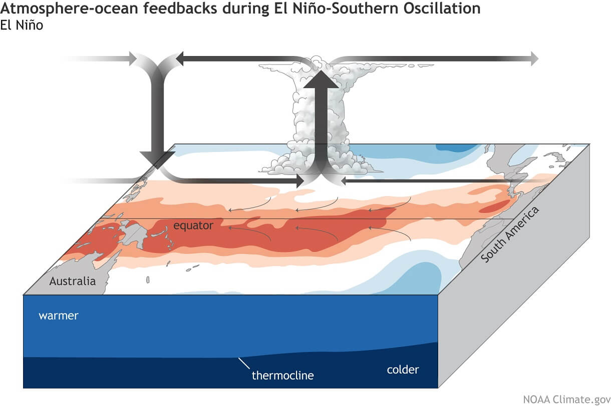
This way, ENSO strongly impacts the tropical rainfall and pressure patterns, affecting the ocean-atmosphere feedback system. Through this ocean-atmosphere system, the ENSO influences the weather globally.
These pressure changes translate into global circulation over time, affecting seasonal weather over both Hemispheres with some delay.
We can observe a global shift in pressure patterns during the emergence of an ENSO phase. But it is usually more influential during the peak of its phase in late Fall and Winter.
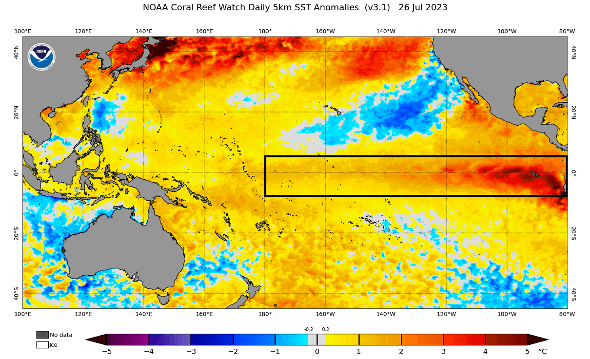
Looking closer at the latest analysis of the ENSO regions below, you can see a strong warm belt spanning across the Equator. And not only that, you can see strong warm anomalies are now entering the eastern parts of the ENSO regions, exceeding 4 degrees Celsius above normal.
Below is the latest 45-day ocean temperature anomaly across the main ENSO regions. You can see a steady warming trend across the region, showing a stable and strong growth of the El Niño event.
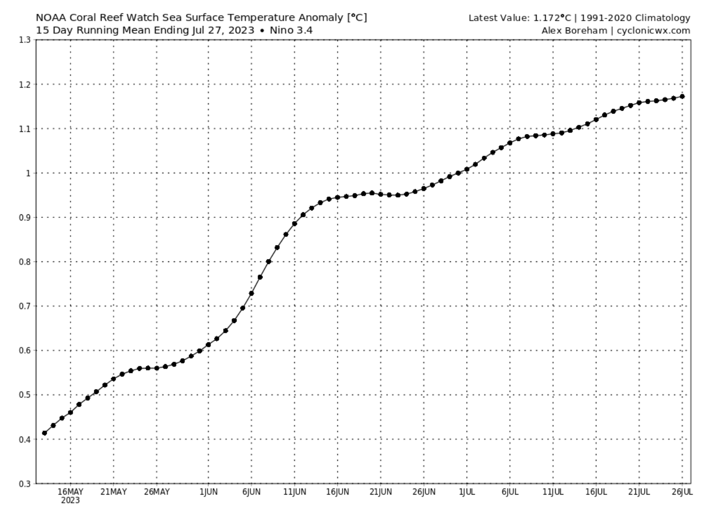
This is expected to continue and peak by the end of the year, with the influence extending into Spring 2024.
You can see the evolution of the ENSO regions in the video animation below. It shows the ocean temperature anomalies from Winter to Spring 2023.
The cold La Niña anomalies quickly broke down over the Winter, with warm anomalies emerging in early Spring. Notice the motion of the anomalies, being driven by the trade winds.
EL NINO FORECAST 2023/2024 WEATHER SEASONS
Below is the latest seasonal forecast for the main ENSO region. The ECMWF forecast takes it over 2 degrees above the average by the end of Fall, considered a strong El Niño event. The stronger the event is, the stronger its seasonal weather impact usually is.
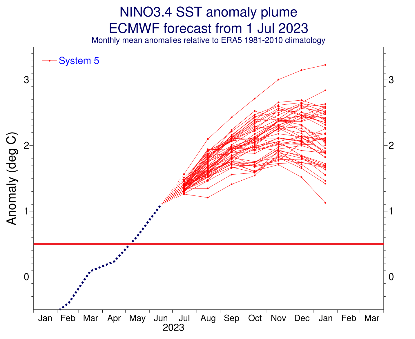
Looking at the extended seasonal ENSO forecast from ECMWF, you can see the ensemble consensus for a strong El Niño event. The green line is the El Niño threshold (+0.5 degrees). The anomalies are forecast to peak into the strong territory, lasting at least into early Spring of 2024.
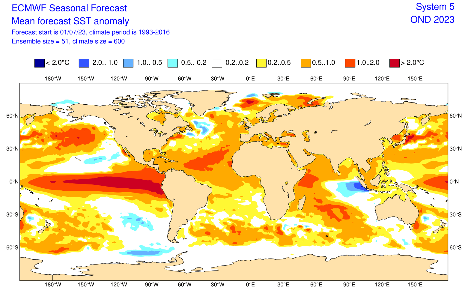
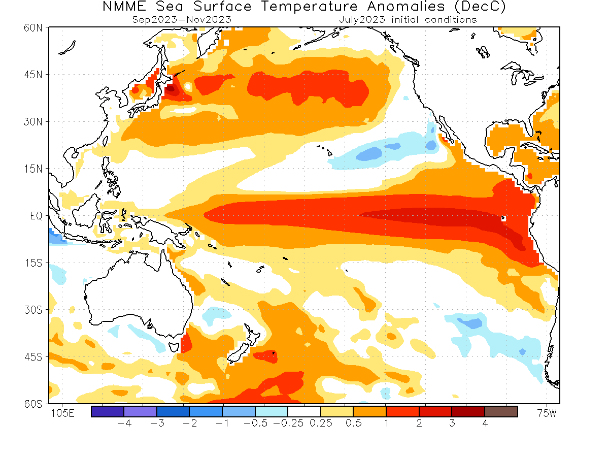
Looking at the Fall (Autumn) ocean forecast by the ECMWF, you can see a strong El Niño event expanding across the entire tropical Pacific. Another area of interest is the unusually warm ocean area in the North Atlantic, which will also play its role in the grand weather picture.
So knowing that we will have an active El Niño event over the Fall, what did its seasonal influence look like in the past?
PAST EL NINO AUTUMN WEATHER PATTERNS
Several Fall/Winter seasons have had an active El Niño phase. Looking back to 1980, there have been 11 such seasons so far.
We produced special graphics showing the combined/average El Niño fall season in the September-November period. Simplified, it shows the prevailing Fall signal during an active El Niño phase.
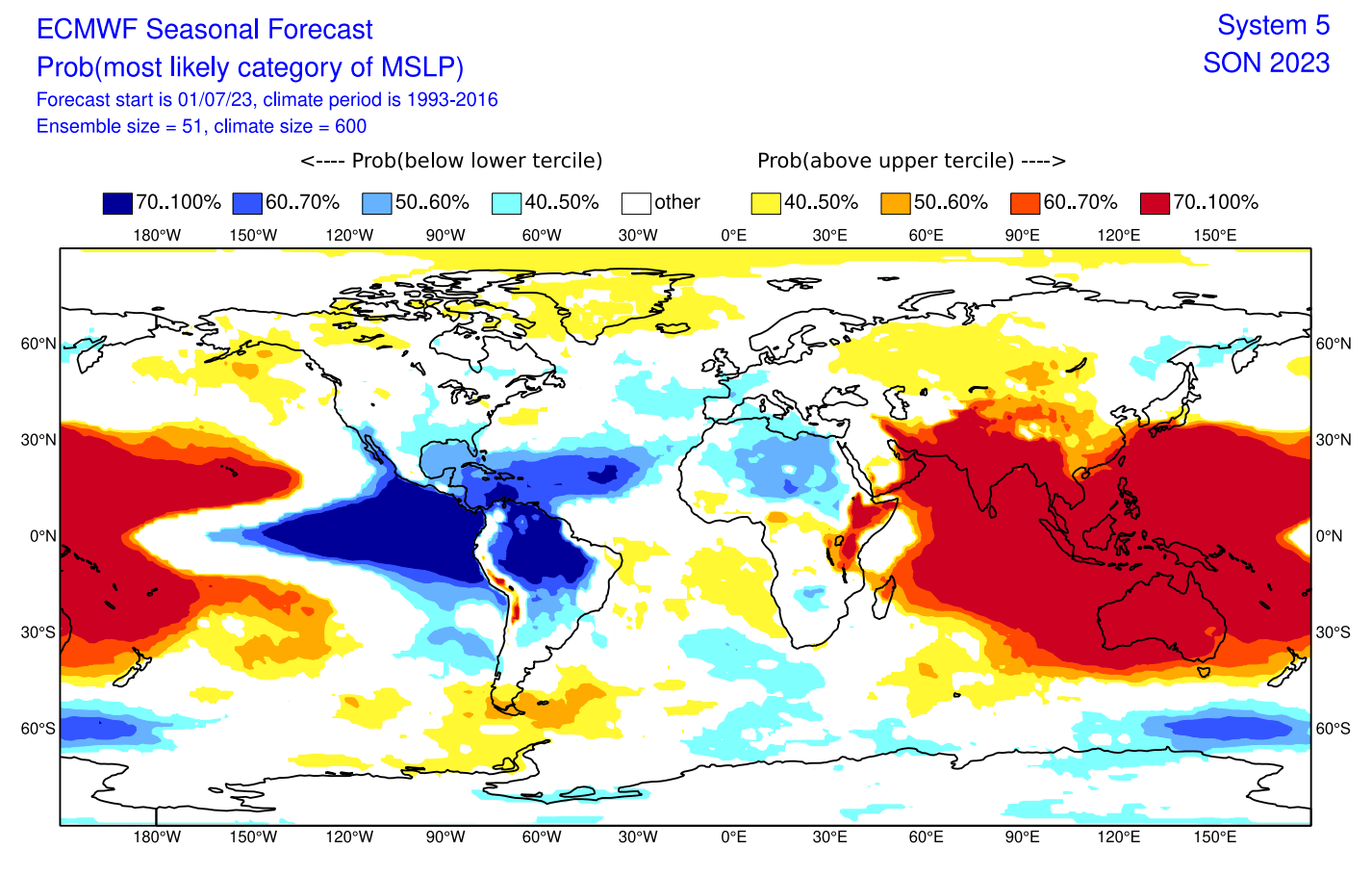
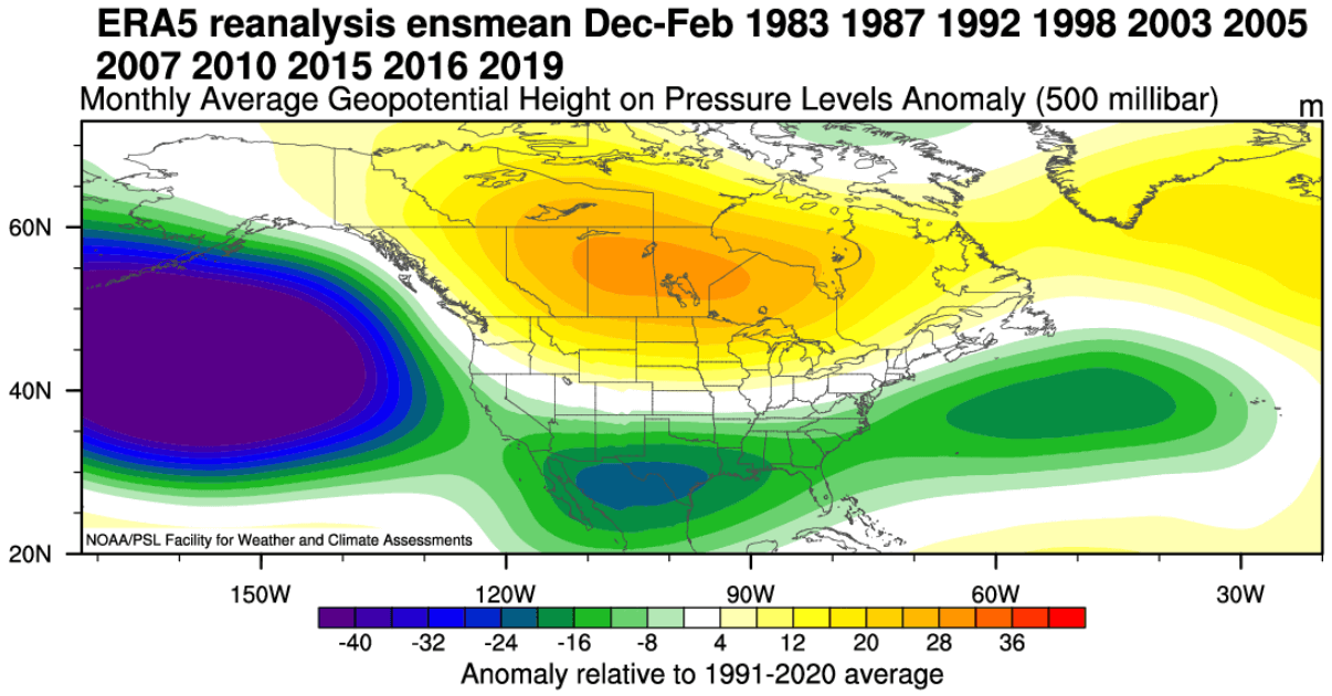
First, we have the pressure pattern, covering the Autumn season. We can see low-pressure zones over Canada and the western United States and a large low-pressure zone over the North Atlantic. This is a positive NAO signal.
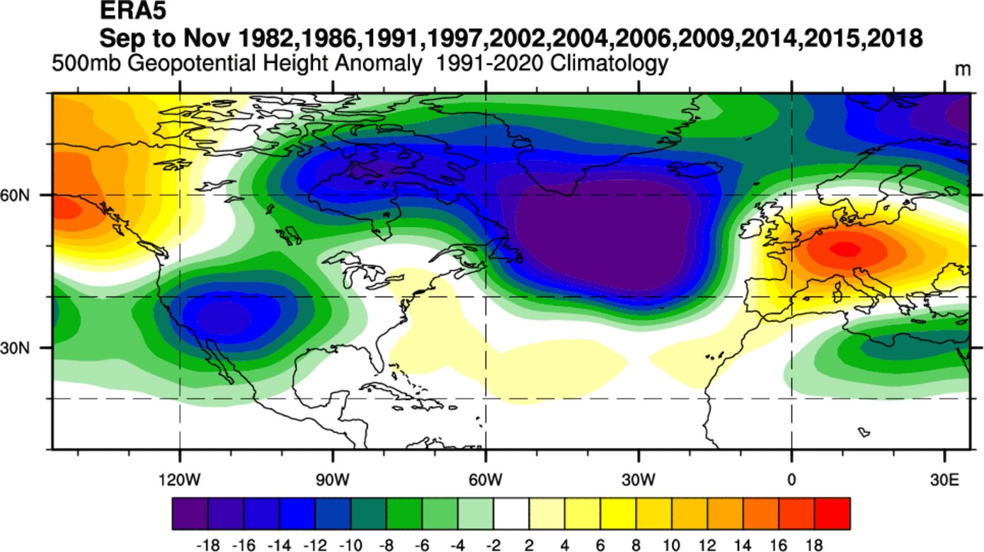
You can also see a high-pressure system over Alaska and Europe. The European high is a response to the positive NAO signal and the strong low-pressure zone in the North Atlantic. Similar goes for the ridging over Alaska and a low-pressure response over the United States.
Next, we have the temperature patterns. You can see a broad negative anomaly over Canada due to the strong positive NAO signal. You can also see a cold signal over the United States and mostly warm weather over Europe under the high-pressure zone.
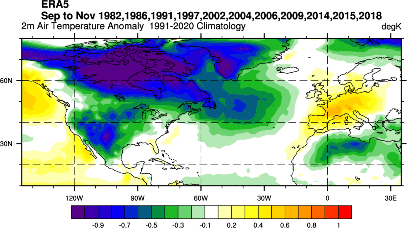
But here, we must add that some of the years in this composite image are from the 80s and early 90s, which generally had lower temperatures overall. That also meant the cold source regions up to the north were colder and could create stronger Fall season cold outbreaks.
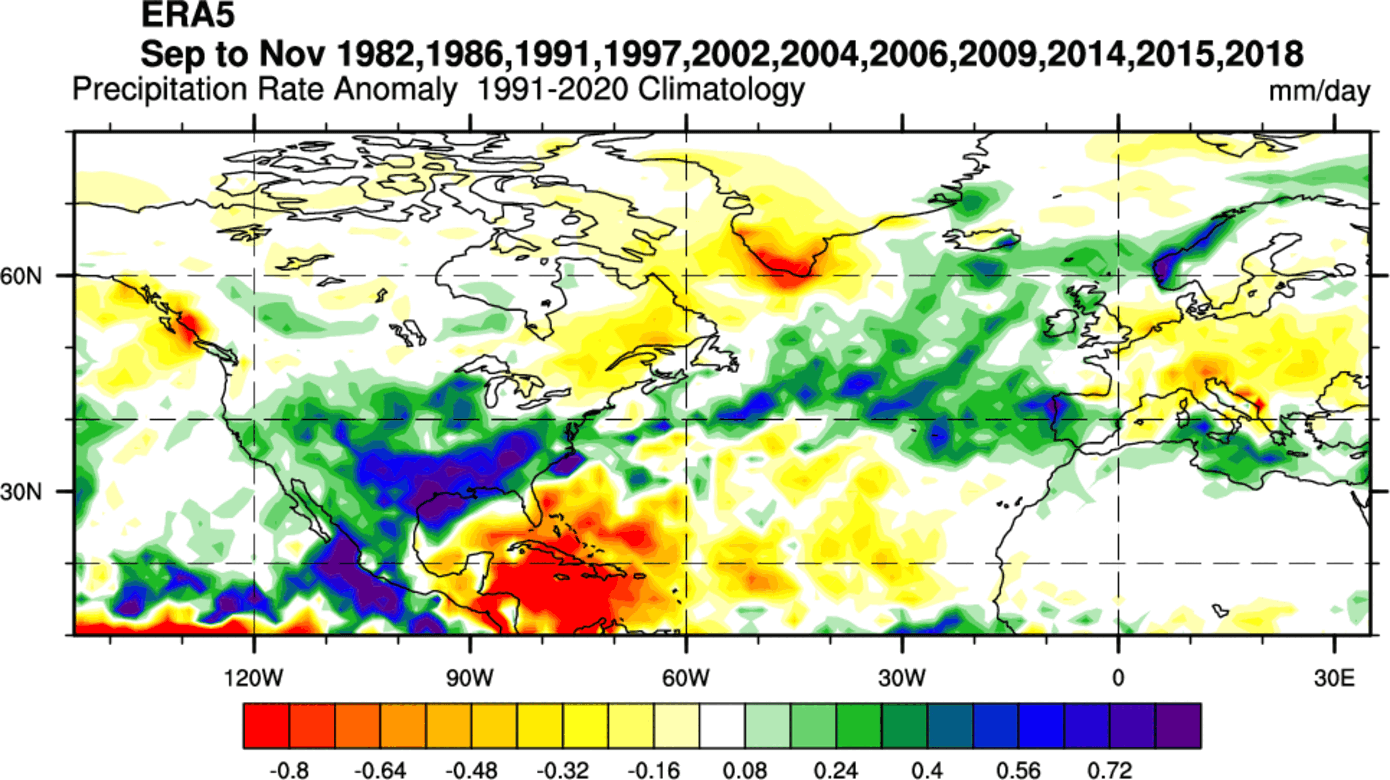
Precipitation patterns in an El Niño Fall season show a strong wet signal over the southern and southeastern United States. Europe is seen mostly drier than normal due to the high-pressure system, apart from the far western and northwestern Europe and Scandinavia, courtesy of the strong low-pressure system in the North Atlantic.
So these are the weather patterns from the actual historical data. But what is the actual long-range forecast showing for the upcoming Fall of 2023?
SUMMER 2023 SEASONAL FORECAST
We will examine the early trends from two seasonal forecasting systems. The ECMWF from Europe and the NMME, which is a combined forecast from several different North American models. We like using two very different forecasting systems because it helps us to see more potential scenarios. It also helps to see how well the model agrees on a certain trend.
ECMWF SUMMER SEASON FORECAST
We often use the ECMWF model, which is generally considered the most reliable. But no long-range/seasonal forecasting system can ever be called “reliable“. This is because we only look at trends and how the weather patterns are evolving on a large scale and over longer periods.
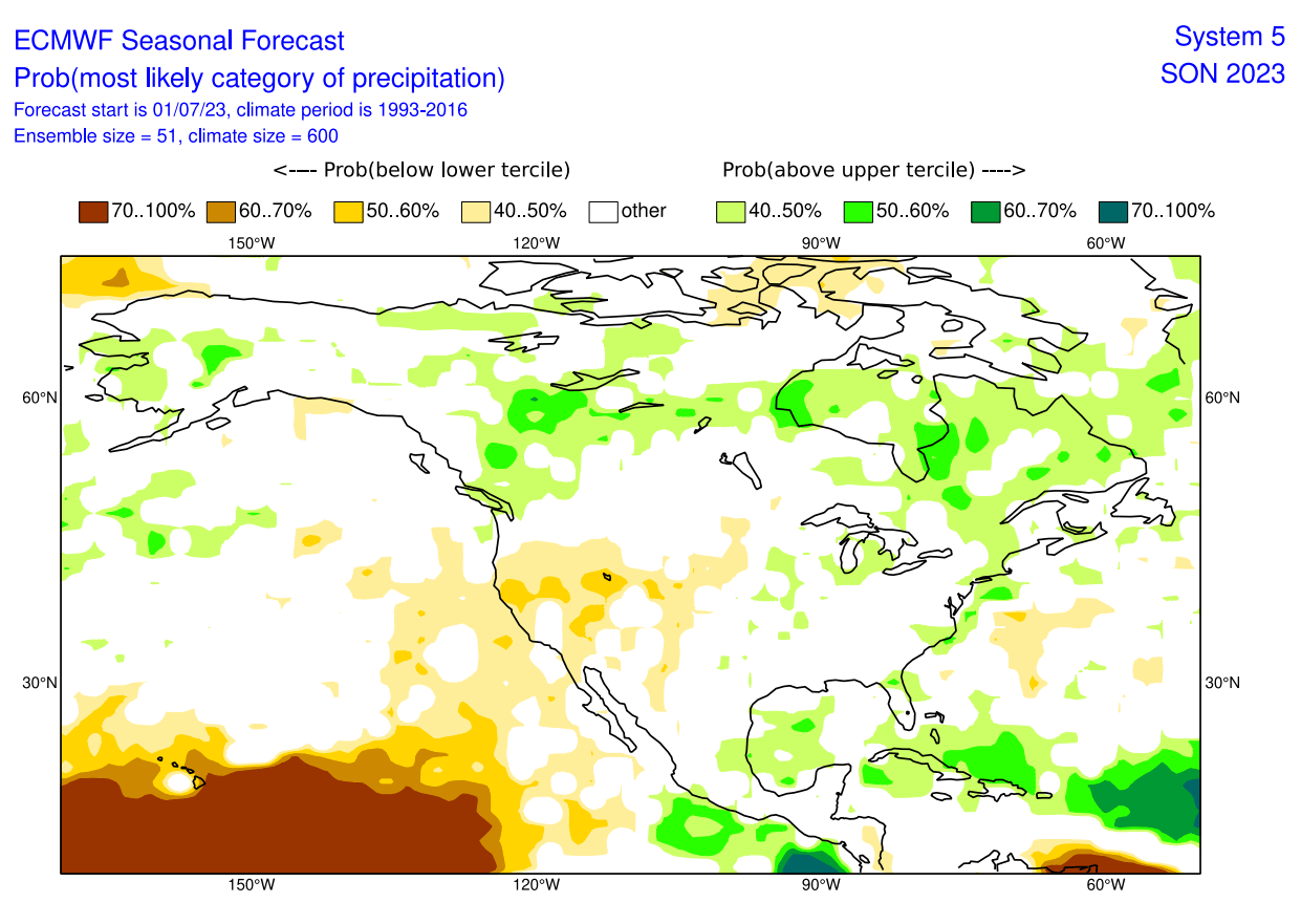
The forecast period we will focus on in all models is September-October-November (SON 2023). This period covers the meteorological Fall. Images are from ECMWF.
The pressure pattern forecast from ECMWF below shows a high-pressure area over the North Pacific and Alaska, similar to the past El Niño seasons. Also, we can see a low-pressure zone indicated over western Canada and the North Atlantic.
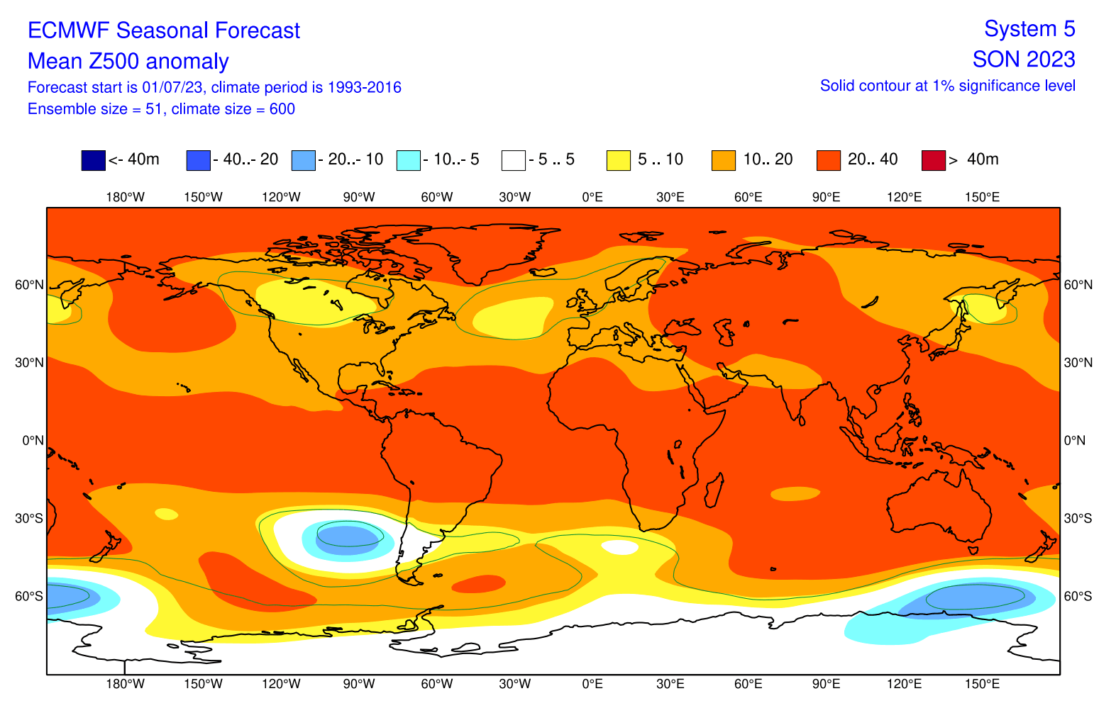
The low-pressure zones are not as profound as in the historical data analysis, but this is just a forecast with a longer lead time. So further updates can show a better picture and more intense systems.
The surface pressure anomaly also shows an interesting pattern over the tropical Pacific. A broad low-pressure zone is forecast to cover the eastern Pacific tropics and the Caribbean. That indicates a typical El Niño pattern. This way, we can look for the El Niño influence on the tropical surface level circulation.
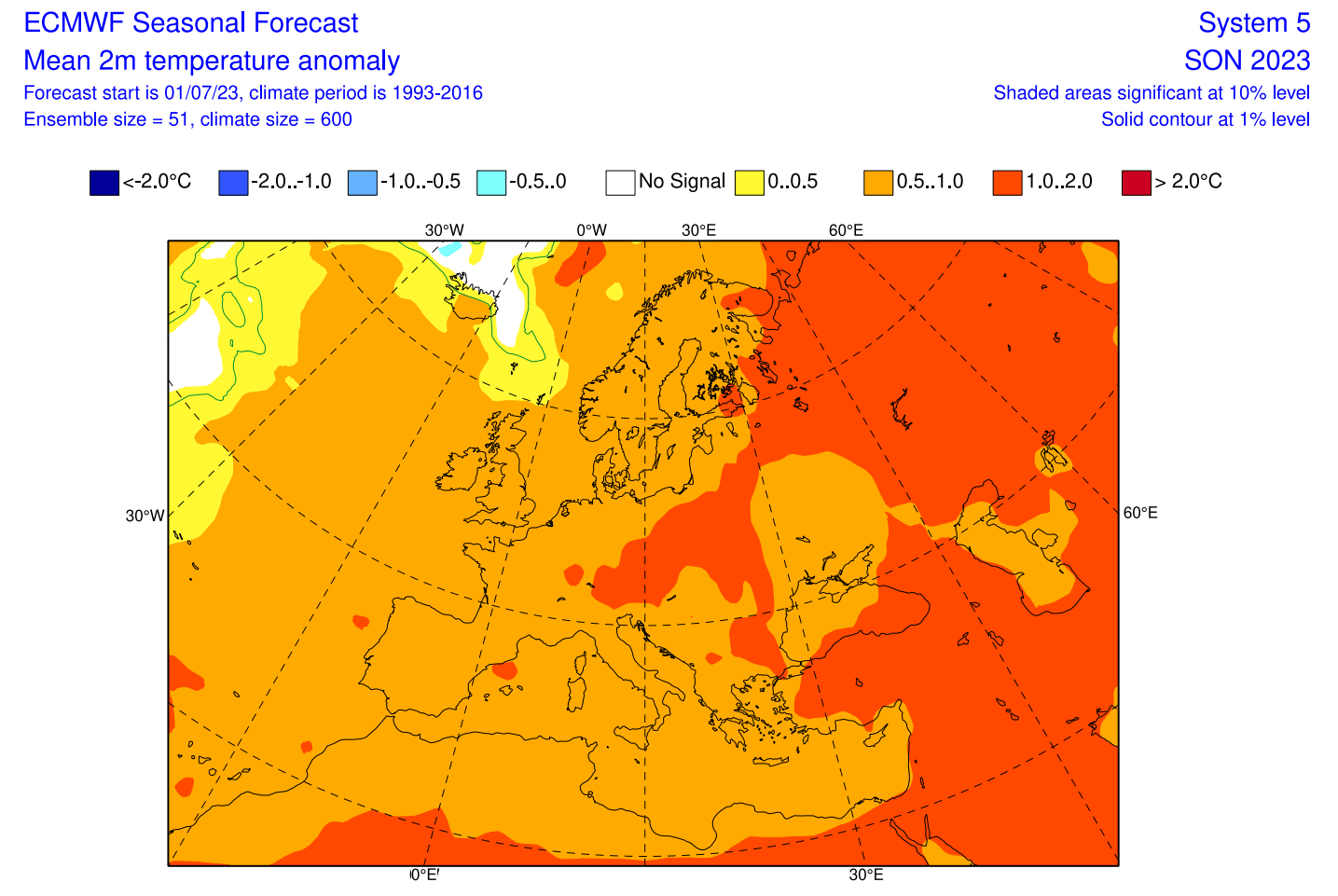
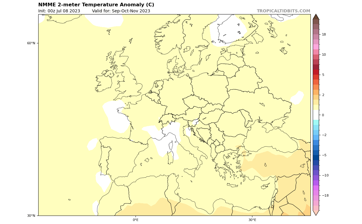
Looking closer at the temperature pattern over Europe, we see warmer-than-normal weather over most of the continent, with a peak over central Europe. This is expected with the low-pressure area signaled in the North Atlantic, producing a more westerly to southerly flow over mainland Europe.
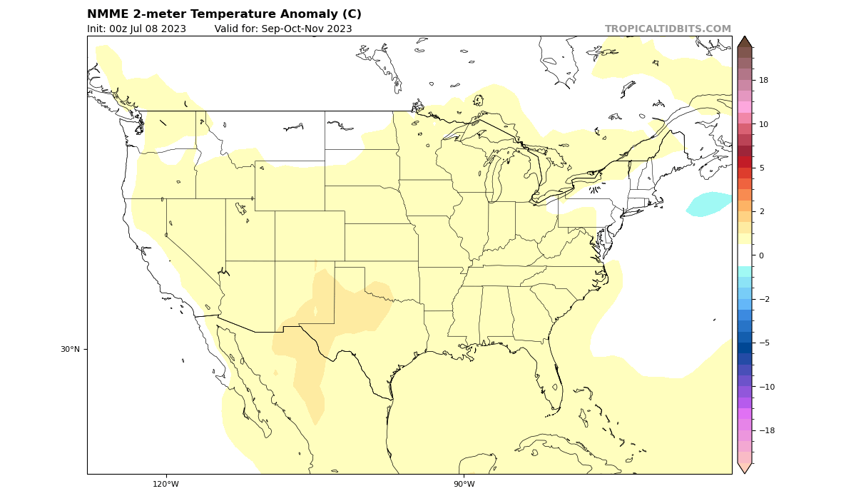
Over North America, we can now see mostly warm anomalies over much of the southern parts of the United States. But we see a neutral zone over central Canada, extending down across the midwest into parts of the central United States.
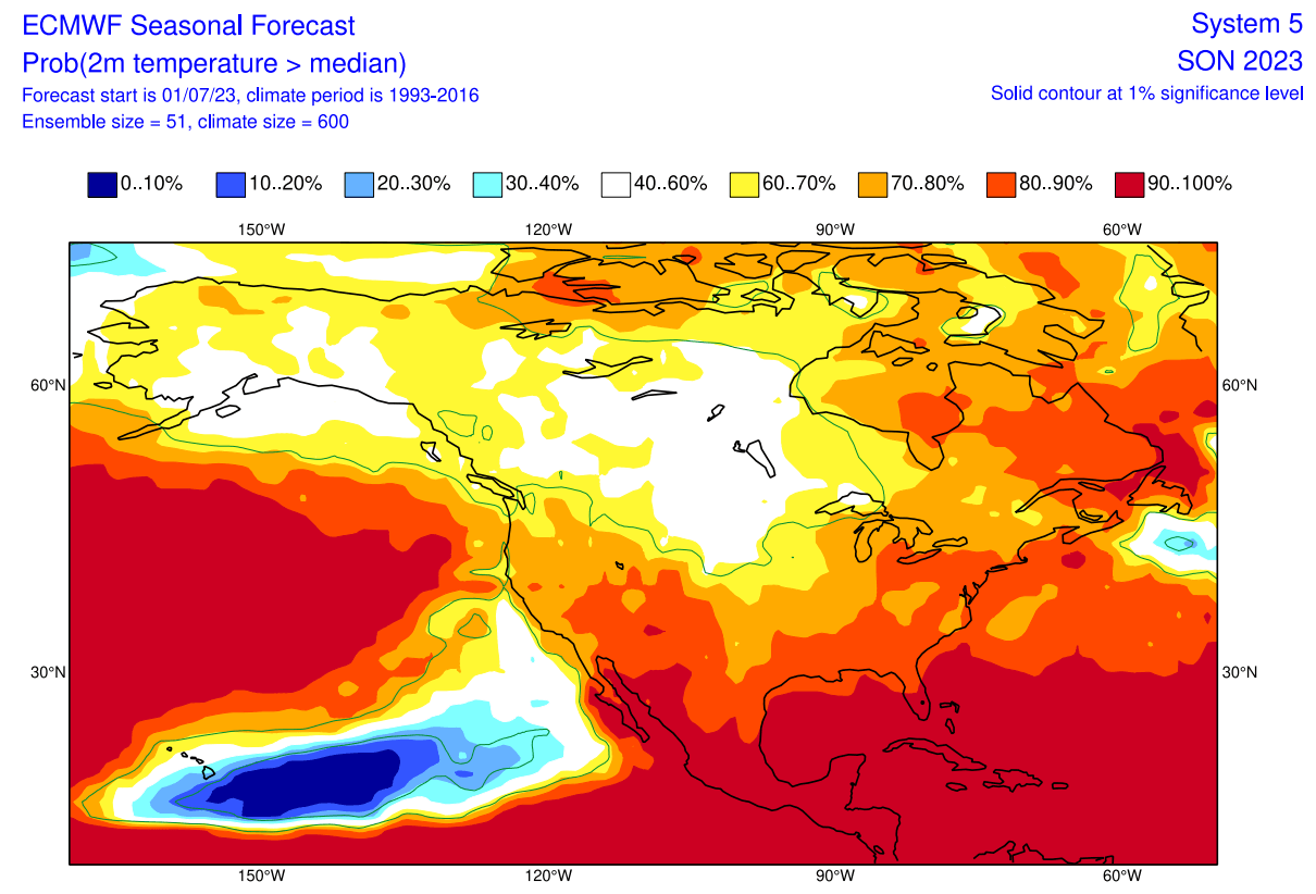
We don’t see any strong cold anomaly signal over the United States, as there is a lack of a low-pressure zone over CONUS. But this is an early forecast, and we see a trend of colder air passing down from Canada over the Midwest into the central parts.
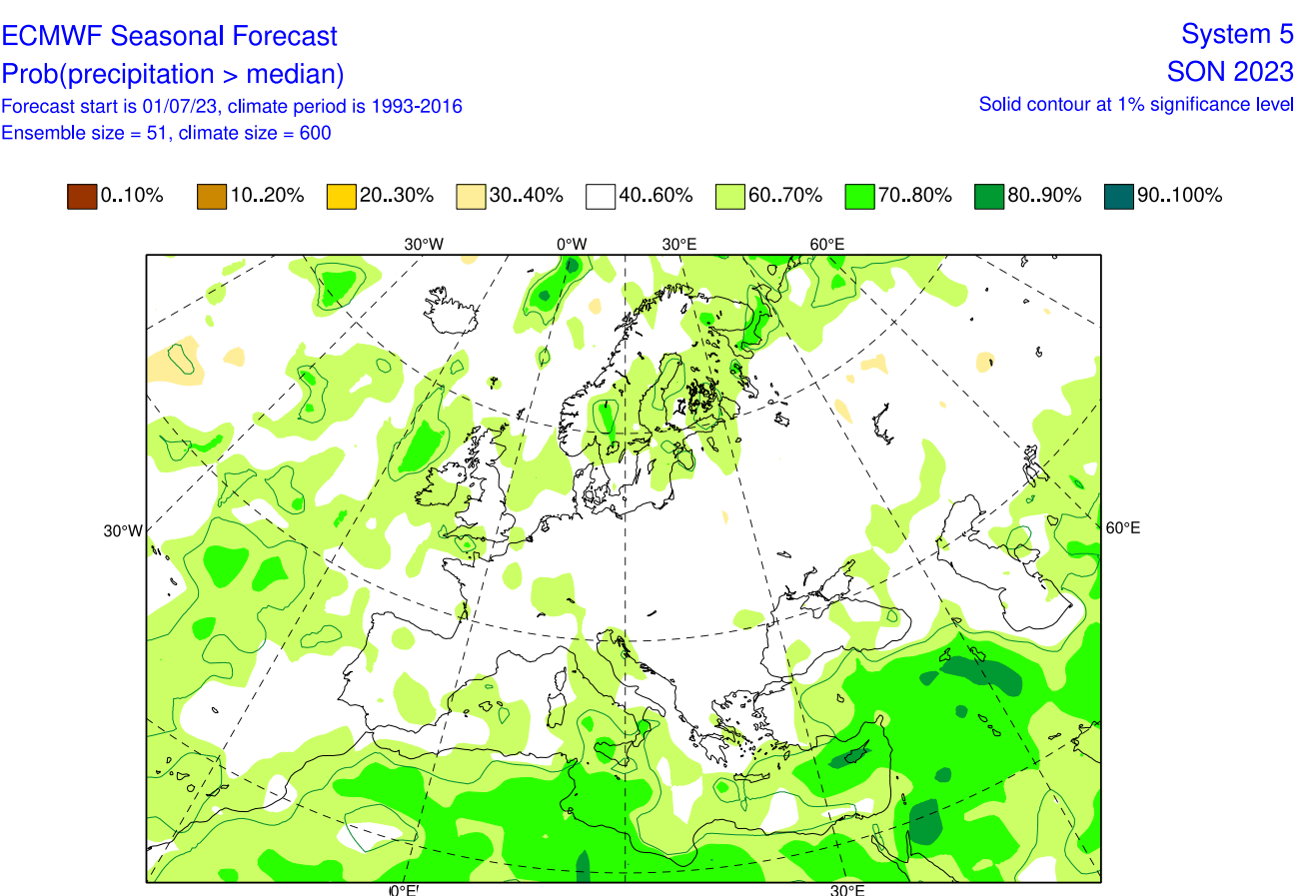
Going to precipitation, we can see mostly normal to wetter conditions over mainland Europe. More precipitation is forecast over northern parts of Europe and the Mediterranean. This is mainly due to the lack of any real high-pressure zone to create stable and dry conditions over Europe.
The precipitation forecast over North America shows drier conditions over the western half of the United States, with more precipitation over southeastern parts and The Great Lakes. More precipitation is also forecast over much of Canada.
 This is only a single model forecast, two to five months in the future, so it is expected to clear out in the next update. But we will now look at a multi-model forecast from many different North American seasonal forecasting systems.
NMME FALL 2023 SEASONAL FORECAST
In contrast to the European models, we tend to use the NMME model system. It stands for North American Multi-Model Ensemble (NMME). It combines several individual models to show an average picture from different solutions.
This system can have high confidence as it covers more scenarios, but the drawback is that the forecast image can get heavily diluted at longer ranges. That is due to the strong variations in the forecast from very different models in the mix.
Looking at the NMME ENSO forecast, you can see it also shows a moderate to strong El Niño event over the Fall weather season. It is forecast to peak during late Fall and early Winter, lasting into the first months of 2024.
Looking closer at Europe, the surface temperatures are warmer than normal over most of the continent. The NMME also has no strong high-pressure system over Europe, so the warm anomalies are not particularly strong.
The North American temperature forecast below shows a warmer Fall over the southern and southwestern parts of the United States. Generally, this shows a warm anomaly across the United States, but this is due to the forecast dilution from very different scenarios in the mix.
However, we see a similar signal to ECMWF, with Canada at neutral temperatures and a slight extension into the northern United States. This is why we can use this NMME system, as we can look for signals that support the main idea or a trend.
Looking at precipitation over Europe, we see mostly wetter Summer conditions across the western and central parts of the continent. This shows a likely positive NAO pattern, with a low-pressure system in the North Atlantic, similar to the ECMWF.
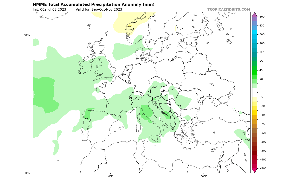
Over North America, we have a very averaged-out forecast due to many models in the mix. But the same trends remain, with drier conditions over the western United States and the Pacific Northwest and wetter signals over the central and eastern United States.
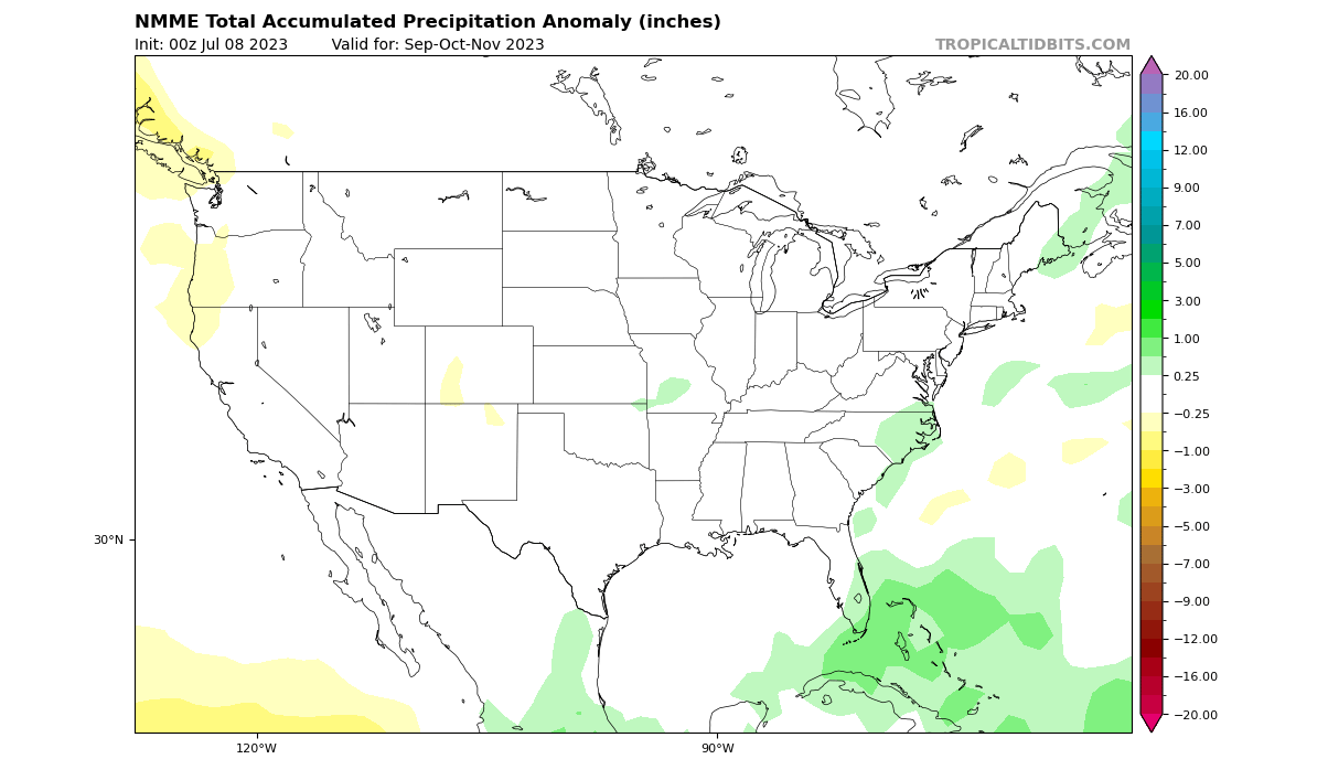
This again shows slight support for the ECMWF forecast, which does trend toward a visible El Niño influence in the overall Fall 2023 weather circulation.
FALL 2023 NOAA UNITED STATES FORECAST
The latest NOAA official Fall temperature outlook shows that western, southern, and far eastern parts of the United States are expected to be warmer than normal. But, just like in the ECMWF forecast, you can see the same trough of normal temperatures, extending from southern Canada down over the Midwest into the central parts.
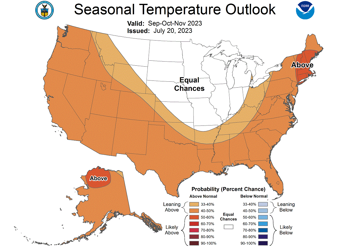
This is the connection to the low-pressure zone over Canada, which will likely send cooler air down into the northern and central United States. Such situations can bring snowfall in the second half of Fall if the cold air source region is cold enough.
The official Fall precipitation outlook is quite similar to the model forecast. We see an equal-to-higher probability for more precipitation over the eastern parts of the United States. NOAA expects drier conditions over the southwestern and northwestern United States.
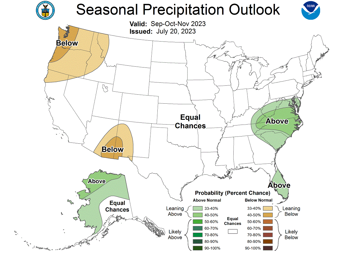
Both models also had a slight tendency for drier conditions over the Pacific Northwest, so this is also a similar idea. But the agreement is smaller than for the high precipitation over the northeast, which is a more high-confidence scenario.
So we can see the signature of the El Niño event in the atmospheric circulation. But how does the El Niño influence then translate into the Winter season?
EL NINO IMPACTS ON WINTER 2023/2024
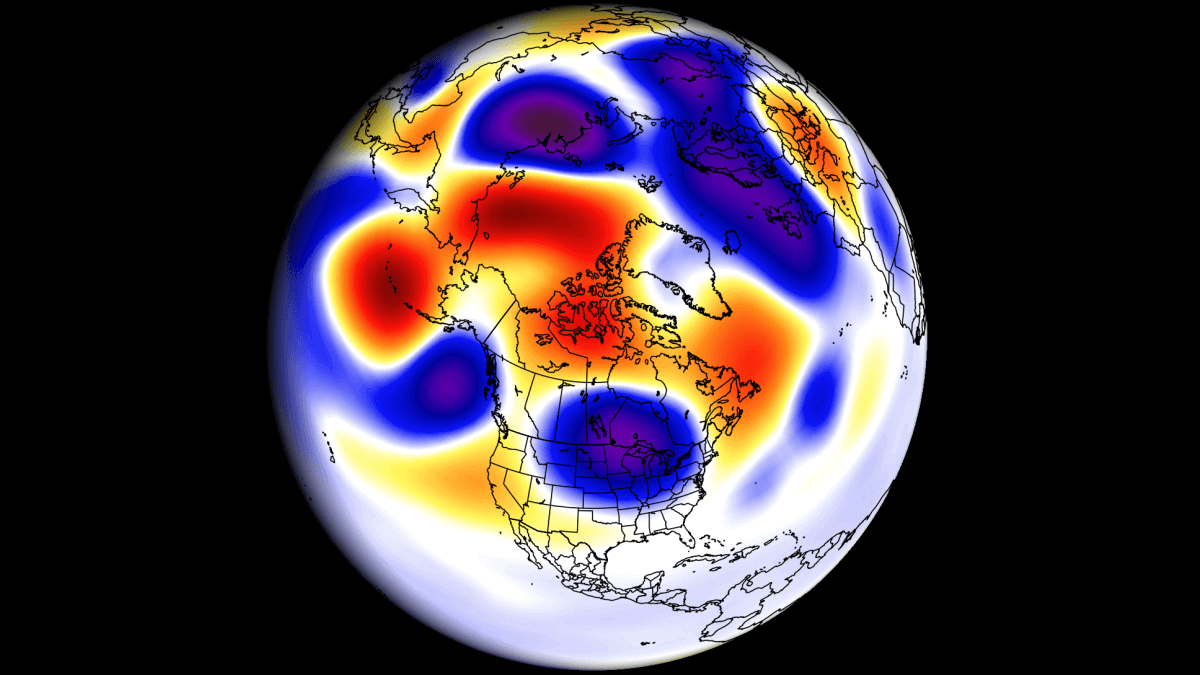
During the El Niño winter season, we usually have a strong and persistent low-pressure area in the North Pacific. That pushes the polar jet stream further north, bringing warmer-than-normal temperatures to the northern United States and western Canada.
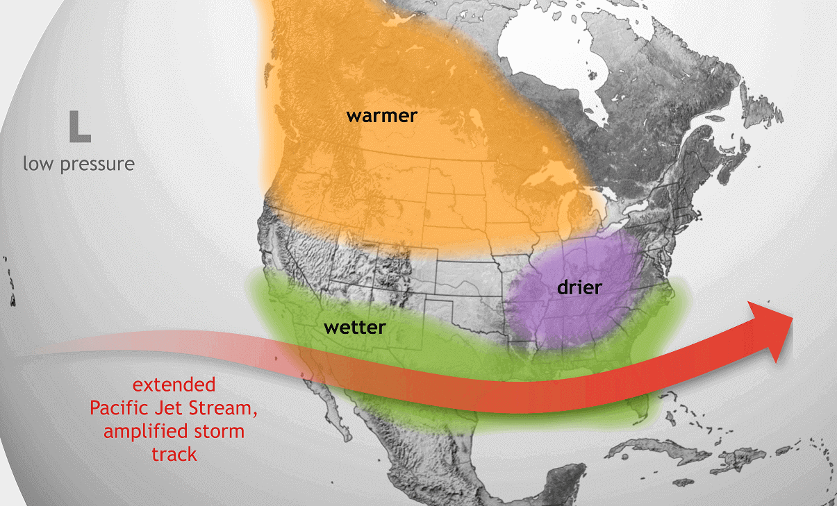
The southerly Pacific jet stream is amplified, bringing storms with lots of precipitation and cooler weather to the southern United States. Depending on the intensity of the cold air, this can bring more snowfall to the central and eastern parts of the United States and the Northeastern United States.
The image below shows the average winter pressure pattern for the past few El Niño winters. You can see a strong low-pressure area in the North Pacific, a high-pressure zone over Canada, and a low-pressure storm track across the southern United States.
The preliminary outlook from the ECMWF for the November-January period shows a very similar pattern. A high-pressure region over Canada and Greenland, with a low-pressure response over the United States and into the North Atlantic.
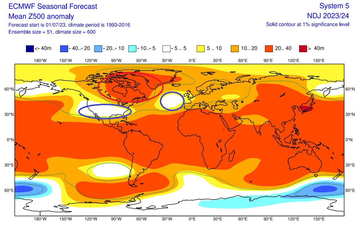
This confirms a strong presence of El Niño in the atmospheric winter circulation.
Below we also have the jet stream anomaly forecast from the Copernicus system. It shows the typical strong subtropical jet stream over the southern United States. Image by meteorologist Ben Noll.
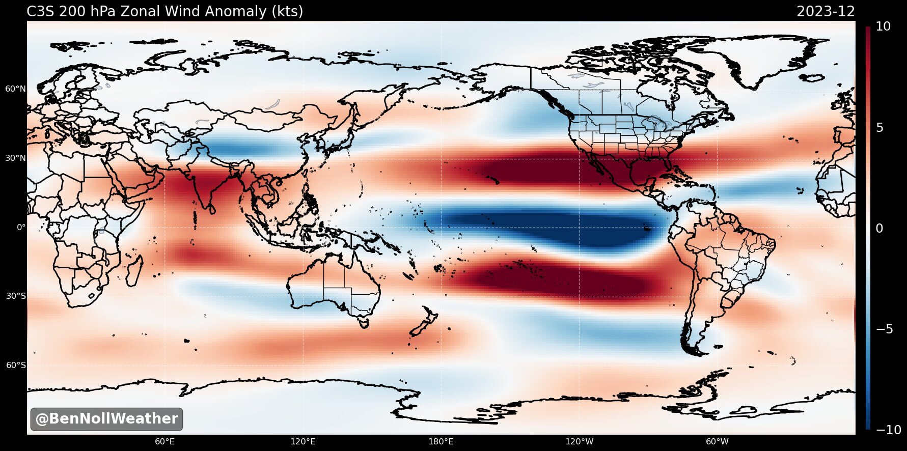
A stronger subtropical jet supports moisture transport into the southern United States and thus increasing the odds for snow events in the southern states and across the Mid-Atlantic. Of course, if there is enough cold air available.
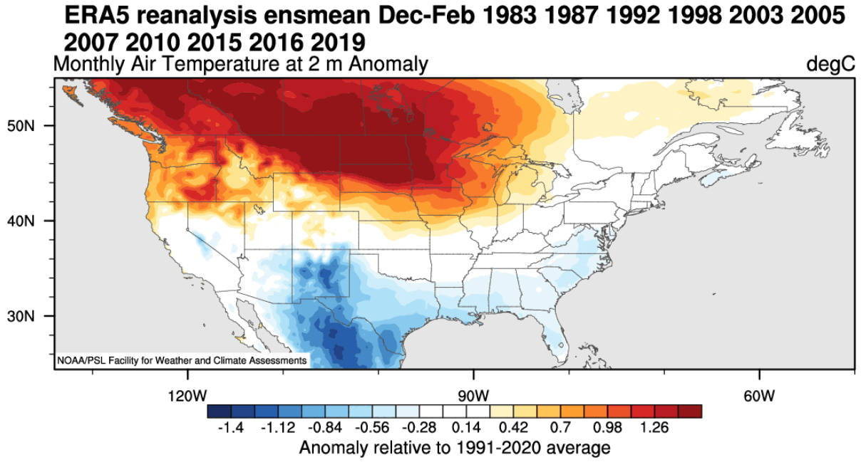
Looking at the temperature anomalies in an El Niño winter, you can see colder temperatures in the southern half of the United States and parts of the eastern United States. The country’s northern half is warmer than usual, as is southern Canada.
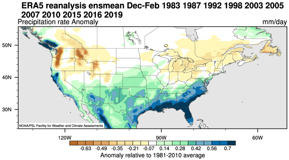
Precipitation-wise, an average El Niño winter brings more precipitation to the southern half of the United States, especially in the Southeast. However, drier winter conditions prevail in the northwestern United States and around the Great Lakes, opposite a La Niña’s influence.
Of course, an El Niño also changes the snowfall patterns, as seen in the image below. There is less snowfall in the northern United States during the El Niño winter seasons, as there is less precipitation. But more snow than normal is seen in the central and southern United States during an El Niño. And also over parts of the northeastern United States.
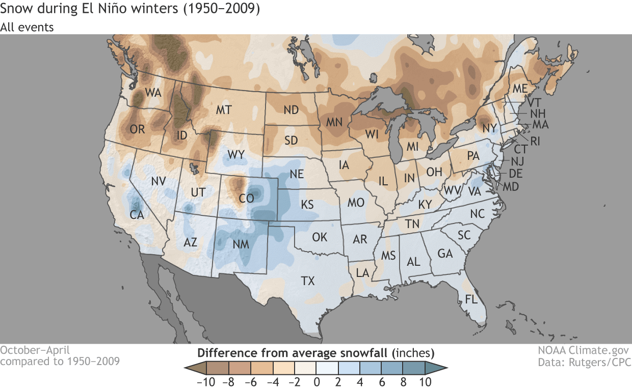
That is mainly due to low-pressure systems trailing across the southern United States. With cooler air available, more moisture increases the chances of snowfall in the southern half. But a lot depends on the availability of the cold air to the north.
We will release regular updates as fresh forecasts and data are available. So make sure to bookmark our page. Also, if you have seen this article in the Google App (Discover) feed, click the like button (♥) there to see more of our forecasts and our latest articles on weather and nature in general.
SEE ALSO: