A few days after a new record high in the Mediterranean Sea, the North Atlantic reached its hottest-ever temperature levels this week. Although we have a strong El Nino underway this year, which statistically results in less tropical activity in the Atlantic, the approaching peak of Hurricane Season 2023 may take advantage of these record-high water temperatures. These conditions could lead to cyclones strengthening faster than usual. And become more intense.
The record-high average sea surface temperature in the North Atlantic is 24.9 degrees Celsius (or 76.8° Fahrenheit), observed on Wednesday, July 26th. It comes after months of unusually high water temperatures observed in the region. The record ocean temperature of the Atlantic happens several weeks earlier than its usual annual peak, according to preliminary data released by the US NOAA last Friday.
To add another cherry on the pie, National Weather Service reported an astonishing water temperature of 38.4 °C (101.1 °F) at Manatee Bay buoy, Florida. This will be the highest sea temperature ever observed on Earth once confirmed.
Note that warmer sea waters lead to the highest potential for more tropical systems, including hurricanes, during the Atlantic Hurricane Season, which lasts from June through November. Additionally, given the so warm waters, the chances for tropical storms reaching the European continent are also higher than usual this year.
While the oceanic waters over the Northern Hemisphere have been on significant anomalies since spring 2023, the Mediterranean Sea was the first to strike out. Let’s see how this evolved before the Atlantic record warmth was set.
MEDITERRANEAN WARMS MORE THAN EVER BEFORE. HEATWAVE SETS ALL-TIME HEAT RECORDS IN THE REGION
On July 26th, the Mediterranean Sea’s average Sea Surface Temperature (SST) reached 28.71 °C (83.7 °F). This is the highest ever temperature observed in recorded history! This beats the previous 28.25 ºC (82.8 °F) set during the European heatwave of August 2003.
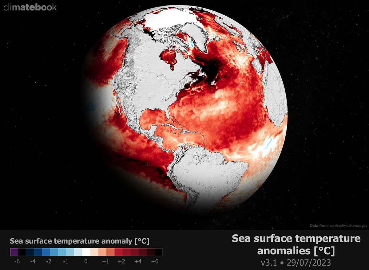
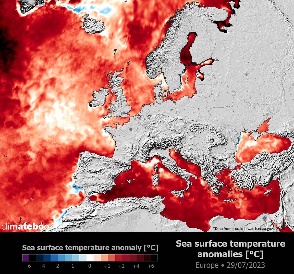
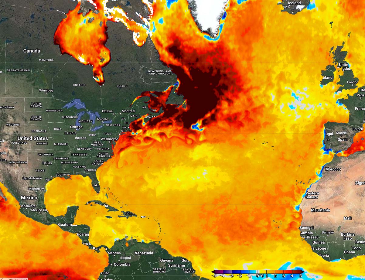
The Mediterranean Sea is 4 to 6 °C above normal at the end of July 2023, while we can see also the other parts of sea waters are significantly anomalous compared to normal.
So, very similar to the historic heat in 2003, the heatwave had the same effect twenty years later. The marine heatwave over the Mediterranean occurred.
The reason behind the marine heatwave and extreme heat over the southern part of Europe was the long-lasting heat dome this summer. Not only did it lead to the record-breaking warmth of the average Mediterranean Sea temperature, but it also contributed to a new July all-time high in Europe.
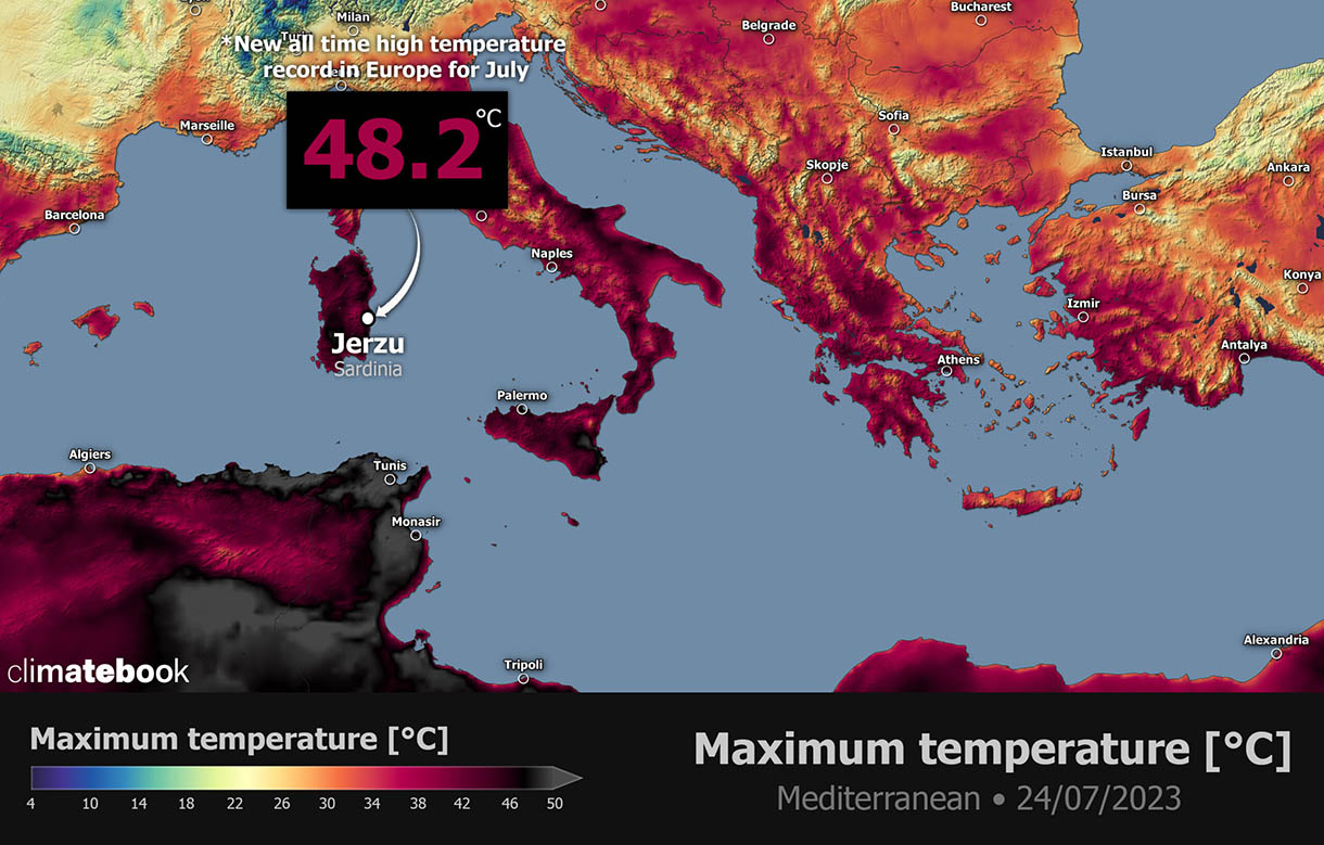
The weather stations in Jerzu and Lotzorai in Sardinia Island, Italy, have reported a maximum temperature of 48.2 degrees Celsius (118.8 °F) on July 24th. This is also the highest temperature in Europe this year, just shy below the all-time high European record. Extreme heat was spread from North Africa, where nearly 50 °C (122 °F) was observed in Algeria and Tunisia.
This marine heatwave sweeping across the Mediterranean Sea region is hitting record-high temperatures, particularly in the central basin. The sea temperature anomalies have spiked to +5.9 °C along the coasts of Italy, Greece, and North Africa.

As said, the Mediterranean Sea reached its highest temperature on record Monday amid an exceptional heat wave lasting for weeks across southern Europe. The record value was announced by Spain’s Institute of Marine Sciences, which analyzed data from satellite observations used by the program Copernicus.
Just a few days later, another breaking news weather event came from the North Atlantic – the highest temperature in the history of measurements was measured.
THE HOTTEST-THAN-EVER AVERAGE TEMPERATURE MEASURED OVER THE NORTH ATLANTIC BASIN
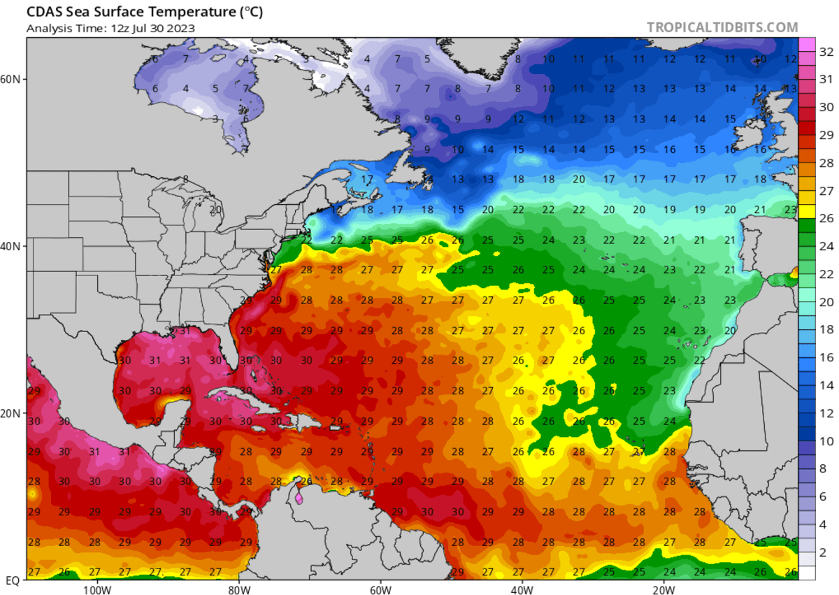
Temperatures at the North Atlantic Ocean surface temperature reached the highest-ever levels in the history of measurements. On Wednesday, July 26th, the daily average temperature of the whole Atlantic Basin was an astonishing 24.9 degrees Celsius (76.8 °F).
What was more shocking than the record value was that the North Atlantic usually reaches its highest temperatures in early September. This means the Basin has a high chance that the record will likely be broken again soon. Possibly even multiple times since we are nearly six weeks away from the statistical peak of the highest Atlantic Basin temperatures.
According to scientists from the US National Oceanic and Atmospheric Administration (NOAA), which has been monitoring sea temperatures since the early 1980s, these preliminary measurements will officially be confirmed in about two weeks.
With the statistical data, the sea surface temperature in the Atlantic Ocean is expected to continue to rise in August towards its usual highest values observed in mid-September every year. The previous record was set last year, in September 2022.
These so-called marine heat waves are becoming more frequent and intense in recent years. This year, they are more persistent and spread over large areas. It is hard work to find near-normal or colder spots of the Atlantic now.
The 24.9 °C mark is more than one degree warmer than a 30-year climatological normal, calculated from 1982 to 2011.
The tropical central and western Atlantic regions remain well-above normal as we head into the final month of meteorological summer 2023. This correlates well with what is typically seen before active Atlantic hurricane season. The near-term SST anomaly forecast also hints temperatures will continue to rise.
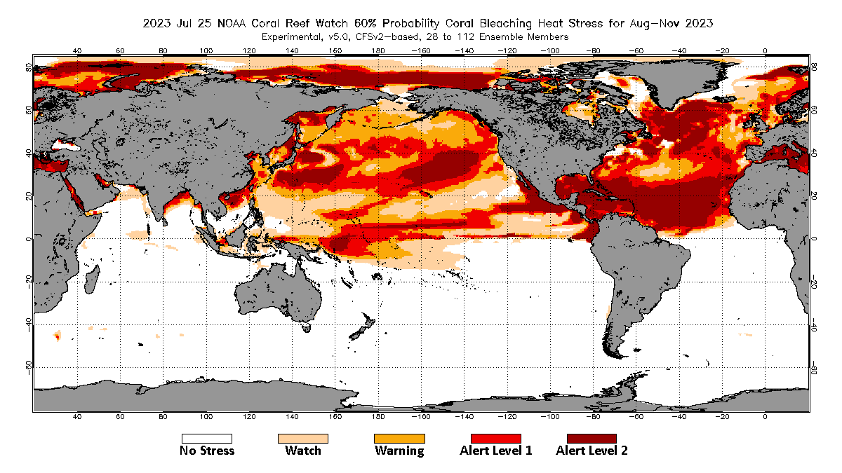
We expect that these sea waters of the North Atlantic will be sufficiently warm enough to support significant tropical development during the peak of the hurricane season from mid/late August into September this year.
During the summer months, we closely monitor Western Africa’s weather conditions. This is where the tropical waves emerge into the eastern Atlantic Ocean. Data shows that nearly 85% of these waves lead to organized deep convection over the warmer oceans and become tropical depressions or storms.
ATLANTIC HURRICANE SEASON 2023 FORECAST
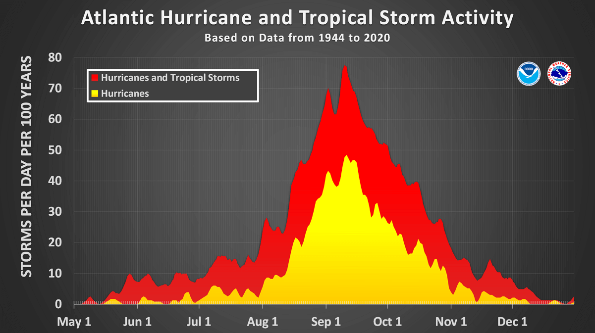
The 2023 Atlantic hurricane season officially started on June 1st. After mid-August, the activity normally starts increasing, toward the peak in September and October.
There was already one Hurricane (Don) and four tropical storms in 2023. This year, the ongoing strong El Nino effect is forecast to bring lesser activity due to stronger wind shear in the tropical region.
However, the unusually warm and hottest-than-ever sea waters of the North Atlantic could increase activity, mainly in terms of the more rapid strengthening of the tropical cyclones and their peak intensity. Research studies have found that the warmer the waters are, the higher the potential for more intense hurricanes.
The seasonal forecasts from the Colorado State University (CSU), led by Dr. Phil Klotzbach, hint at 18 named tropical systems, with nine hurricanes and four major storms forecast for hurricane season 2023. That’s well above the 30-year average. Based on the long-term average, a hurricane season normally brings 14 named storms, seven hurricanes where three reach a major intensity (Category 3 or greater).
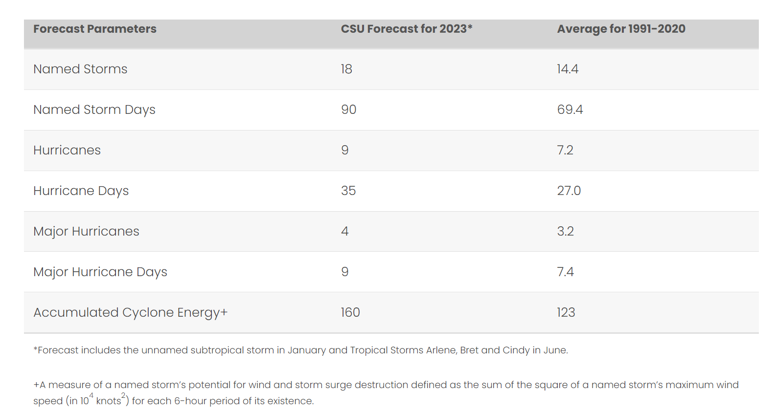
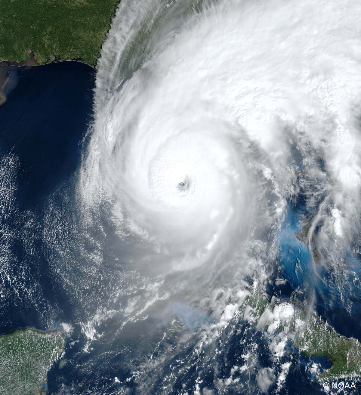
Judging by these pre-peak outlooks, the Atlantic hurricane season 2023 could be stronger than the one we had last year. To keep things on track, the 2022 hurricane season produced 16 total systems, where 14 of those were storms, 8 were hurricanes, and 2 were major hurricanes. Those major hurricanes were Fiona (Category 4) and Ian (Category 5), both occurred in September 2022.
This is a NOAA visible satellite view of Category 5 Hurricane Ian in the final days of September when it was nearing the southwest Florida peninsula.
The Atlantic hurricane season runs from June 1st through November 30th. The region we monitor these storms is known as the Atlantic basin, which covers the tropical area, including the entire Atlantic Ocean, the Gulf of Mexico, and the Caribbean region.
The long-term average of tropical systems in the Atlantic Basin (taken over the last 70 years – between 1951 and 2020) holds 11 named storms in one full hurricane season. However, the short-term average (taken over the last 15 years – between 1995 and 2020) is higher, with around 14 named storms. We can notice a gradual increase in the number of storms.

While a La Nina global weather pattern influenced the last three seasons, the 2023 hurricane season will have an El Nino effect. Which NOAA forecasts to peak in the fall months. El Nino is known to lead to lesser tropical activity due to stronger wind shear in the Atlantic Basin.
However, despite El Nino throughout the year, and this year’s well-above-average Atlantic seawater temperatures, the upcoming hurricane season is again expected to be busy. These warmer-than-normal sea temperatures are also observed across the Caribbean and the Gulf of Mexico.
The video animation above represents the global and tropical region sea temperature anomaly; temperatures are well-above normal. We can see how warmer the Pacific waters are developing, meaning El Nino is underway. At the same time, the Atlantic, the Caribbean, and the Gulf are warmer than normal, including across the region known as MDR (the Main Development Region – between Africa and the Caribbean Sea).
This indicates that upcoming tropical cyclone formation will fuel from the very warm and hottest-than-ever ocean waters when hurricane season activity ramps up.
A tropical storm or a hurricane organizes and gains its strength when specific weather conditions are met. Normally, hurricanes need a low-shear environment with very warm sea waters. The latter results in plenty of very moist air mass above the sea.
COULD ATLANTIC HURRICANE SEASON 2023 TAKE ADVANTAGE OF THESE RECORD-BREAKING WARM WATERS, DESPITE STRONG EL NINO INFLUENCE?
Historical and statistical data over the recent decades have shown that during the El Niño event, the global circulation in the tropical region in the Atlantic reduces the number of hurricanes and tropical storms.
This is mainly because a positive ENSO phase results in stronger wind shear, thus preventing the tropical storms from organizing into powerful and large systems. Contrary, wind shear is lower when we have a La Nina or negative ENSO phase, and support of tropical developments is better.

Our re-analysis and early update on El Nino of pressure trends during an El Niño event have shown that there is mostly higher pressure across the tropical Atlantic, right when there is the main development region of tropical systems.
This generally leads to a tendency to have less or weaker low-pressure systems in the Main Development Region (this region, in short, is known as MDR) during the Hurricane season due to the El Niño influence.
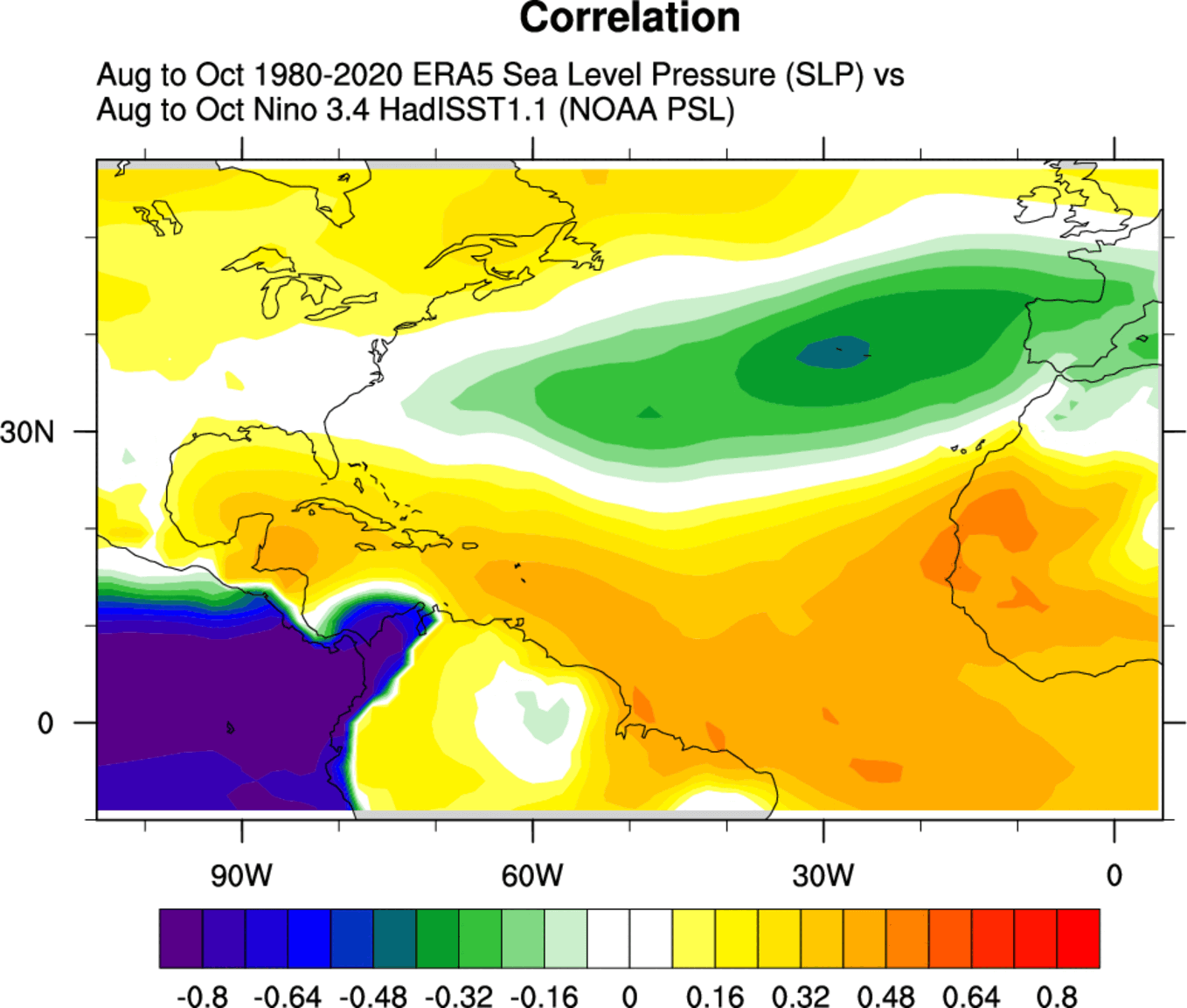
Historical data also showed that during an El Niño hurricane season, the Gulf of Mexico, the Caribbean, and most of the tropical Atlantic are drier than average. This is well correlated with the higher pressure and more stable conditions across the MDR region.
So fewer tropical storms and weaker systems in short. But in 2023, the El Niño event comes out with something different. While we normally observe warming Atlantic Ocean temperatures from April through September, the recent observation of record-breaking waters has come to our attention; here is why.
RECORD-WARM ATLANTIC COULD BOOST TROPICAL STORMS AND HURRICANE INTENSITY
As we discussed earlier above, the extremely high water temperatures across the Atlantic, including the Main Development Region, have something that has never been observed before. This means that one of the main conditions that fuel tropical cyclones is particularly anomalous – the heat content.

For a tropical storm and a hurricane to form, two meteorological features must be present:
- A weather disturbance, such as a cluster or thunderstorm that pulls in warm surface air (dewpoints) from all directions
- The water at the ocean’s surface has to be at least 79° Fahrenheit (26° Celsius)
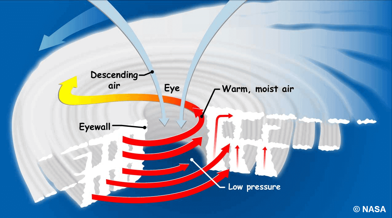
Because we interact with warm air and seawater that spawns these storms, tropical cyclones form over the oceans between about 5 and 20 degrees of latitude. At these latitudes, seawater is warm enough to give the storms strength and the rotation of the Earth, which makes them spin.

So, in general, hurricanes start with the evaporation of warm seawater, which pumps water into the lower atmosphere. This significantly humid air mass is dragged aloft when converging winds collide and turn upwards.
As air rises into higher altitudes, water vapor condenses into clouds and rain, releasing heat that warms the surrounding air, causing it to rise. With the air far above the sea moving upward, even more, warm moist air spirals in from along the surface to replace it.
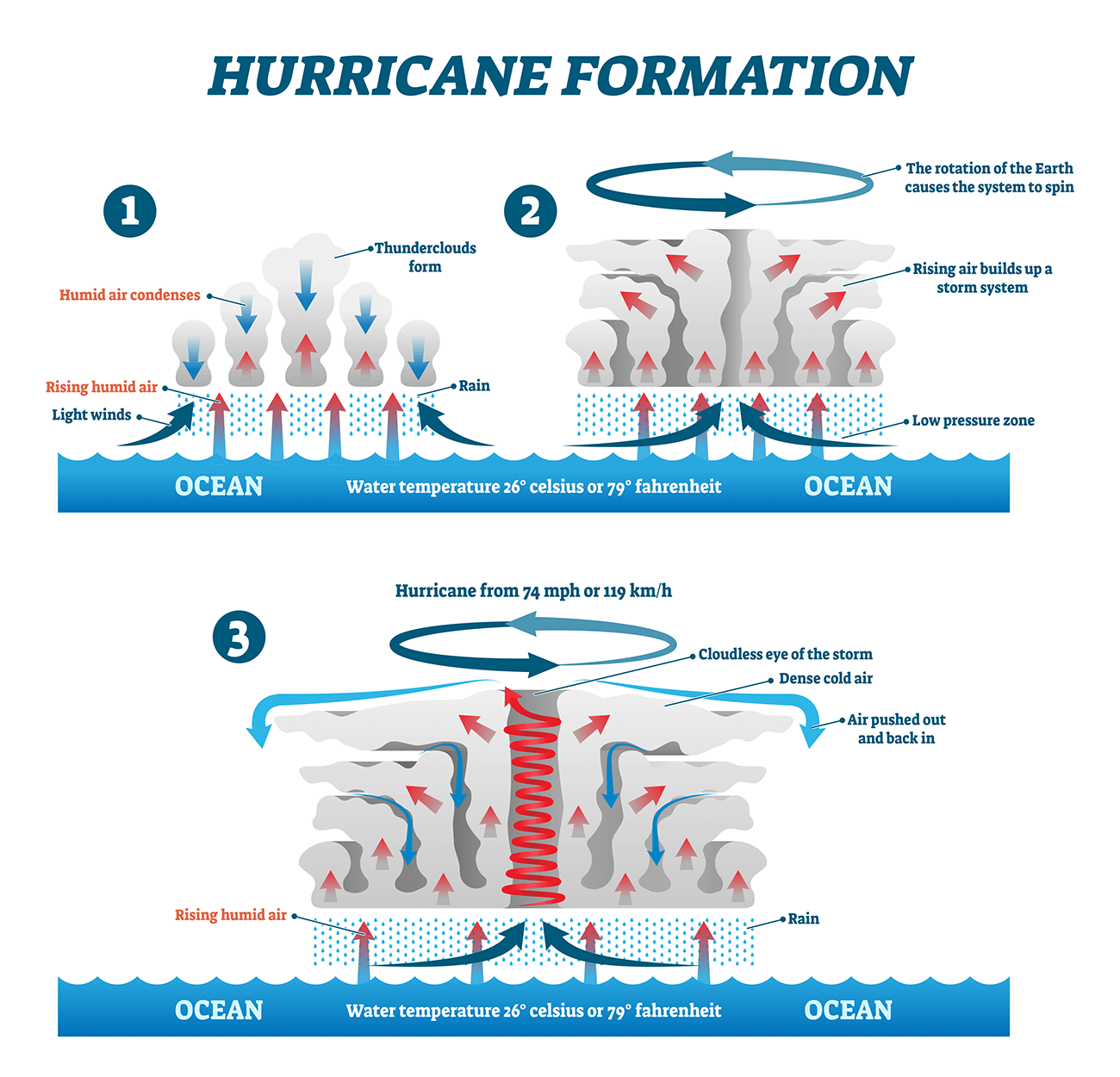
Therefore, as long as the base of this weather system remains over warm water and high-altitude winds do not shear apart its top, the tropical cyclone will be strengthening and growing. More and more heat and water will be pumped into the air.
The surface central pressure at its core will drop further, sucking in the wind at ever-increasing speeds. Over several hours to days, the tropical storm (cyclone) will intensify, finally reaching hurricane strength. A tropical system in the Atlantic officially gets a Hurricane status when the winds that swirl around it reach sustained speeds of 74 miles per hour (64 knots or 119 km/h) or more.
Warmer oceans provide more potential energy for the tropical systems, leading to stronger storms or even more rapid intensification when they grow. Recent studies have shown a link between ocean surface temperatures and tropical storm intensity – The warmer waters lead to more intense storms.
So, as we learned, the two main ingredients tropical systems need for their formation and strengthening are (1) a weather disturbance and (2) warm ocean waters. The latter has been in the record values for the whole North Atlantic.
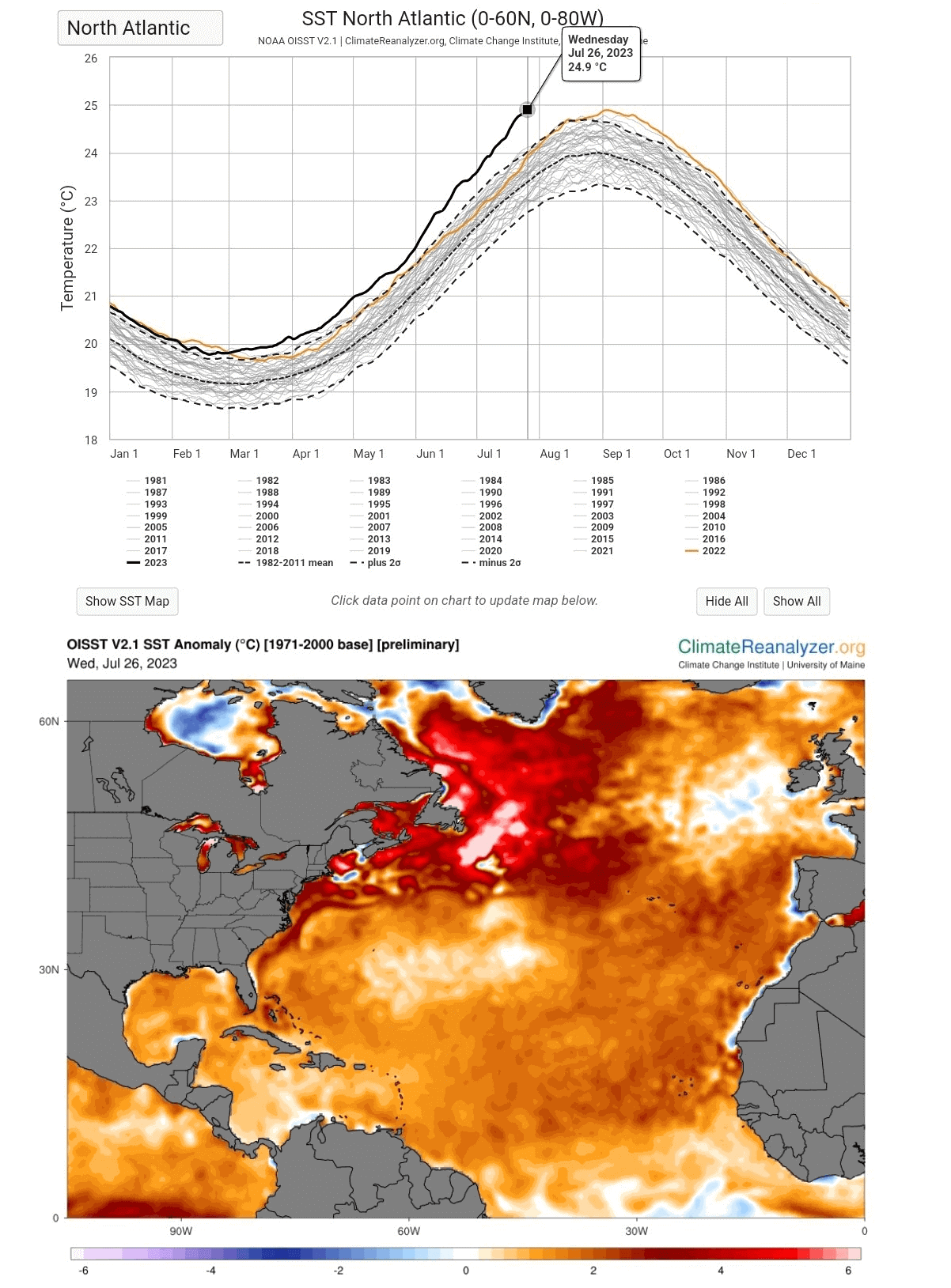
The above chart represents the Atlantic Ocean’s average temperature over the years, with the 2023 curve running significantly out of the normal standard deviation. This has been so anomalous since early spring. It is hard to find near or below-normal temperatures right now; the Atlantic Ocean is overheating.
And this happened weeks before the seasonal peak, which generally occurs in September, right at the peak of the Atlantic Hurricane Season.
To conclude, within the next several weeks, North Atlantic average sea temperatures will likely be broken again. This leads to an enhanced chance that the upcoming tropical systems and hurricanes will take advantage of these conditions and support explosive and rapidly developing storms.
HURRICANE SEASON 2023 ALREADY HAD FIVE STORMS SO FAR
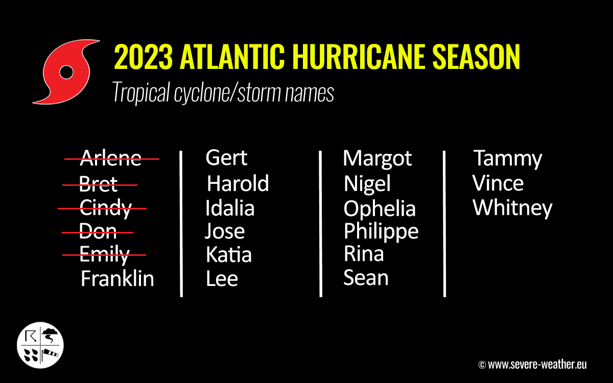
The WMO’s international committee (the World Meteorological Organization) has designated 21 storm names for the Atlantic hurricane season 2023. The list with all the storm names can be seen below, starting with Arlene and ending with Whitney.
So far, five tropical systems have formed in the first two months of this Hurricane Season. Four tropical storms, while Dom was also upgraded into a Category 1 Hurricane in the central North Atlantic last week.
We use tropical cyclones’ names for one main reason – to help quickly identify storms in warning messages.
Names simplify user communication, with Alphabetical order of storms
Systems with a certain name are presumed to be much easier for the public and meteorologists to remember. Therefore, it is made easier like this, compared to numbers and other more technical terms that could be used for their identification among meteorological offices and the public at the end.

Above; Hurricane Don in mid-July 2023
Besides simple storm names, it is also easier for the general media to report on tropical systems forming, so the warning messages with storm names are straightforward information for anyone involved in their path.
Ultimately, these simple messages increase public awareness, which is the most important regarding particularly dangerous weather events.
Furthermore, the advantages of the storm names are quite important in exchanging detailed information about the ongoing systems between various users, including coastal bases and ships traveling at sea, and indeed also between the various meteorological offices (e.g., Storm Prediction Center, which focuses on convective outlooks across the U.S. and the National Hurricane Center).
To have the most valuable information from a storm naming system, NOAA meteorologists alphabetically arranged a list of names.
Therefore, this year, a storm with a name that begins with the letter ‘A,’ Tropical Storm Arlene, was the first storm to occur. The last letter is ‘W.’ Therefore, Whitney, it will be for the hurricane season 2023.
SAFETY PREPAREDNESS DURING A HURRICANE SEASON

Have a plan
The official hurricane season in the North Atlantic and the Caribbean starts on June 1st and ends on November 30th. This is when you and your family must be prepared by planning.
- Make sure to write down emergency phone numbers and keep them on the refrigerator or near every phone in your house. Program them into your cell phone as well.
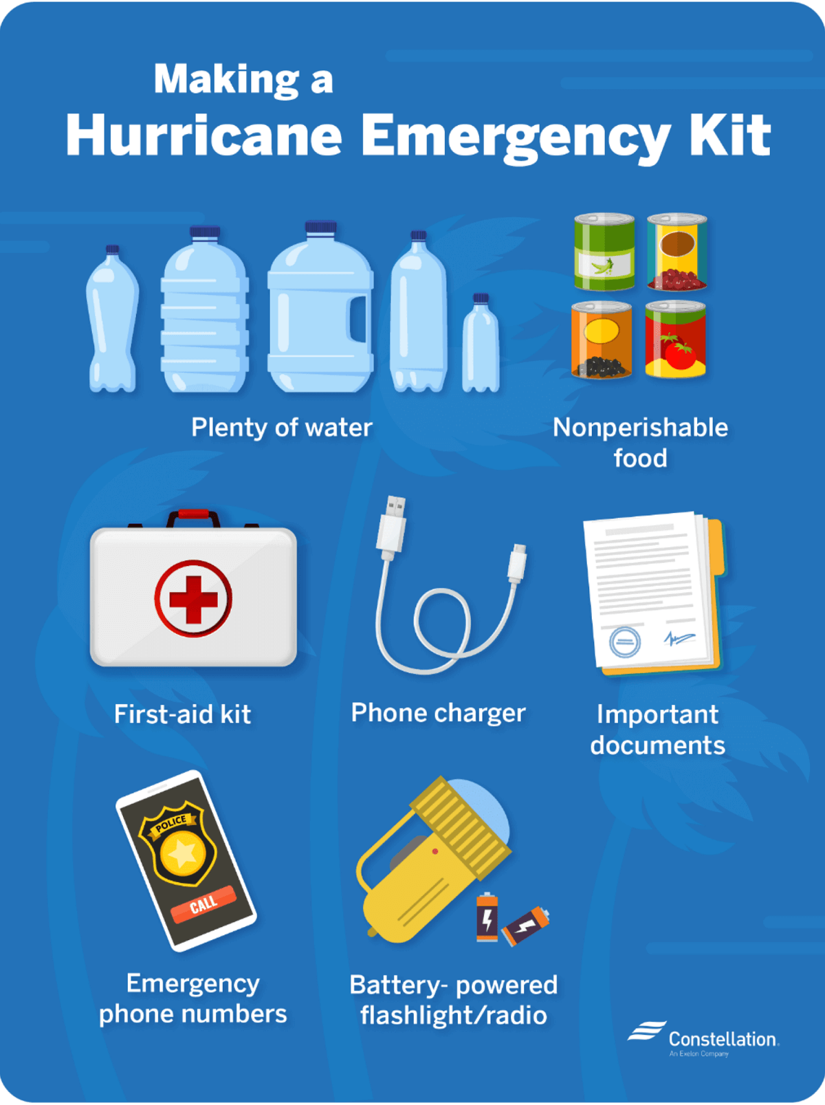
- Prepare an emergency supply kit.
- Locate the nearest shelter in your area and different routes from your home in an emergency. If shelter locations in your area have yet to be identified, learn how to find them before the event of a storm.
- Pet owners: Take care of your pets at pre-identify shelters, a pet-friendly hotel, or an out-of-town friend or relative where you can take your pets in case of an evacuation. Local animal shelters can offer advice on what to do with your pets if you are asked to evacuate your home during a hurricane.
LEARN THE DIFFERENCE BETWEEN A HURRICANE “WATCH” AND “WARNING”
When you listen to the National Weather Service alerts on TV or radio or check for them online, there are two kinds of alerts:
- A hurricane watch means hurricane conditions (sustained winds of 74 miles per hour [mph] or higher) are possible in a stated area. The National Hurricane Center (NHC) will announce hurricane watches 48 hours before they expect tropical storm-force winds (sustained winds of 39 to 73 mph) to start.
- A hurricane warning is a more serious threat to deal with. It means hurricane-force winds are expected in a stated area. NHC issued these warnings 36 hours before tropical-storm-force winds were expected in the area to give people enough time to prepare for the storm.
Check out the National Weather Service’s Hurricane Center for more information about hurricane watches and warnings. If you hear a hurricane watch or warning in your area, you can take steps to get ready.
GET YOUR CAR READY TO LEAVE HOME IF NEEDED
Make sure your car is ready before the tropical storm or hurricane hits.
- Fill the gas in your car’s tank.
- Move cars and trucks into your garage or under cover.
- Always keep an emergency kit in your car.
If you don’t own a car, consider making plans with friends and family or call authorities to get a ride if you need to evacuate.
GET YOUR FAMILY AND PETS READY
- Go over your emergency plan with your family; understand everything.
- Keep checking for weather updates about the storm. Watch TV, listen to the radio, or check the NHC website online.
- Call the hospital, public health department, or the police about special needs. If you or a loved one is older or disabled and won’t be able to leave quickly, get their advice on what to do.
- Put pets and farm animals in a safe place.
GET YOUR HOME READY
- Clear your yard to ensure nothing could blow around during the storm and damage your home. Move bikes, lawn furniture, grills, propane tanks, and building material inside or under the shelter.
- Cover up house windows and doors. Use storm shutters or nail pieces of plywood to the outside window frames to protect your windows. This can help keep you safe from flying debris, pieces of shattered glass.
- Be ready to turn off your power if you see flooding, downed power lines, or you have to leave your home. Switch your power off completely.
- Fill clean water containers with drinking water if you lose your water supply during the storm. You can also fill up your sinks and bathtubs with water for washing.
- Double-check your carbon monoxide (CO) detector’s battery to prevent CO poisoning.
BE READY TO EVACUATE OR STAY AT HOME
During a hurricane warning, always listen to authorities regarding whether you should evacuate or stay home.

If a hurricane is coming, you may hear an order from authorities to evacuate (leave your home). Never ignore an order to evacuate. Sturdy, well-built houses may not hold up against a hurricane’s power. Staying home to protect your property is not worth risking your family’s health and safety.
There are occasions when you may hear an order to stay at home. If driving conditions are too dangerous, staying home might be safer than leaving. Respect the authorities’ decisions.
If you need to evacuate:
- Grab your emergency supply kit and only take what you need (cell phone, chargers, medicines, identification like a passport or license, and cash).
- Unplug your appliances. If you have enough time, turn off the gas, electricity, and water.
- Follow the roads that emergency workers recommend even if there’s dense traffic expected. Other routes might be blocked or already flooded. Never drive through flooded areas, as cars and other vehicles can be swept away or may stall in just 6 inches of moving water.
- Contact your local emergency management office and ask if they offer accommodations for owners and pets.
If you need to stay home:
- Keep your emergency supply kit anywhere where you can easily access it anytime.
- Follow weather updates online from NHC, and listen to the radio or TV for updates on the hurricane.
- Stay inside. Even if it looks calm, don’t go outside. Wait until you hear an official message that the hurricane is over. Sometimes, the weather gets calm in the middle of a storm but then quickly worsens again.
- Stay away from windows — you could get hurt by flying debris, such as pieces of broken glass or other objects winds pick up around the neighborhood during the storm. Stay in a room with no windows, or go inside a closet.
- Be ready to leave home. If emergency authorities order you to leave or your home is severely damaged, you may need to go to a shelter or a neighbor’s house.
Our expert forecaster team will actively follow the tropical region activity worldwide, including Atlantic Basin systems and tropical cyclones likely to affect the United States, the Caribbean, and Europe again in the following months.
Stay tuned for further follow-up posts, in-depth forecast discussions, and nowcasting during the coming weeks and throughout the upcoming Atlantic hurricane season 2023 peak months. We will make you prepared.
Remember to bookmark our page to have all the new info ready anytime. Or click ‘show more’ if you read this article from the Google Discover feed.
Copernicus, Climate Reanalyzer, NOAA, NHC, Colorado State University, Tropical Tidbits, and WHO provided images used in this article.
We thank our partner ClimateBook for providing high-quality graphics in this article.
See also: