A large-scale atmospheric phenomenon is currently changing its phase high in the atmosphere. Called “the heartbeat of the atmosphere,” it has a known effect on the Winter weather and will combine its influence with the El Nino event to impact the weather patterns in the 2023/2024 Winter season.
This atmospheric phenomenon is called Quasi-Biennial Oscillation (QBO short), a changing wind anomaly in the tropical stratosphere. Its presence has been well known for many decades, and it plays its role in the Winter season pattern development.
But the global weather system is complex, and there is never one factor to rule them all. So we are first going to look at the large-scale winter circulation and the seasonal anomalies that will play a major role in the upcoming cold weather season of 2023/2024, which we can already see and analyze.
ATMOSPHERIC WINTER CIRCULATION
The large-scale weather drivers can be found in different parts of the atmosphere and, of course, in the ocean. There are many layers to the atmosphere, but our weather unfolds in the lowest layer of the atmosphere, called the Troposphere.
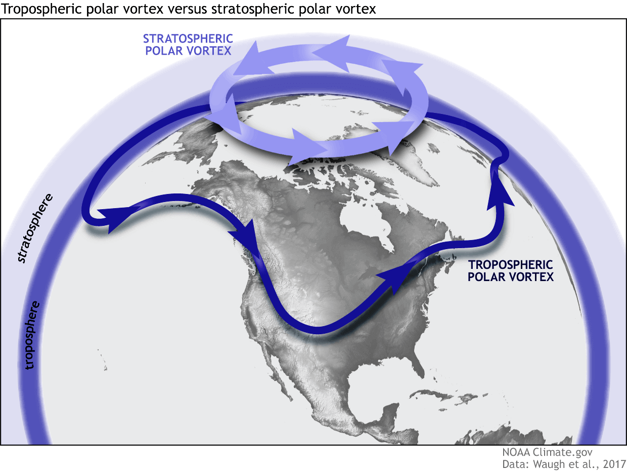
But above that, we have the Stratosphere, also the home of the ozone layer. Both layers have their circulation and are connected in many different ways. The overall winter circulation of the entire atmosphere is called the Polar Vortex.
That is why we separate the entire winter circulation (Polar Vortex) into an upper (stratospheric) and a lower (tropospheric) part. Both parts play their role differently, so we monitor them separately. But how they are connected is also very important—image by NOAA-Climate.
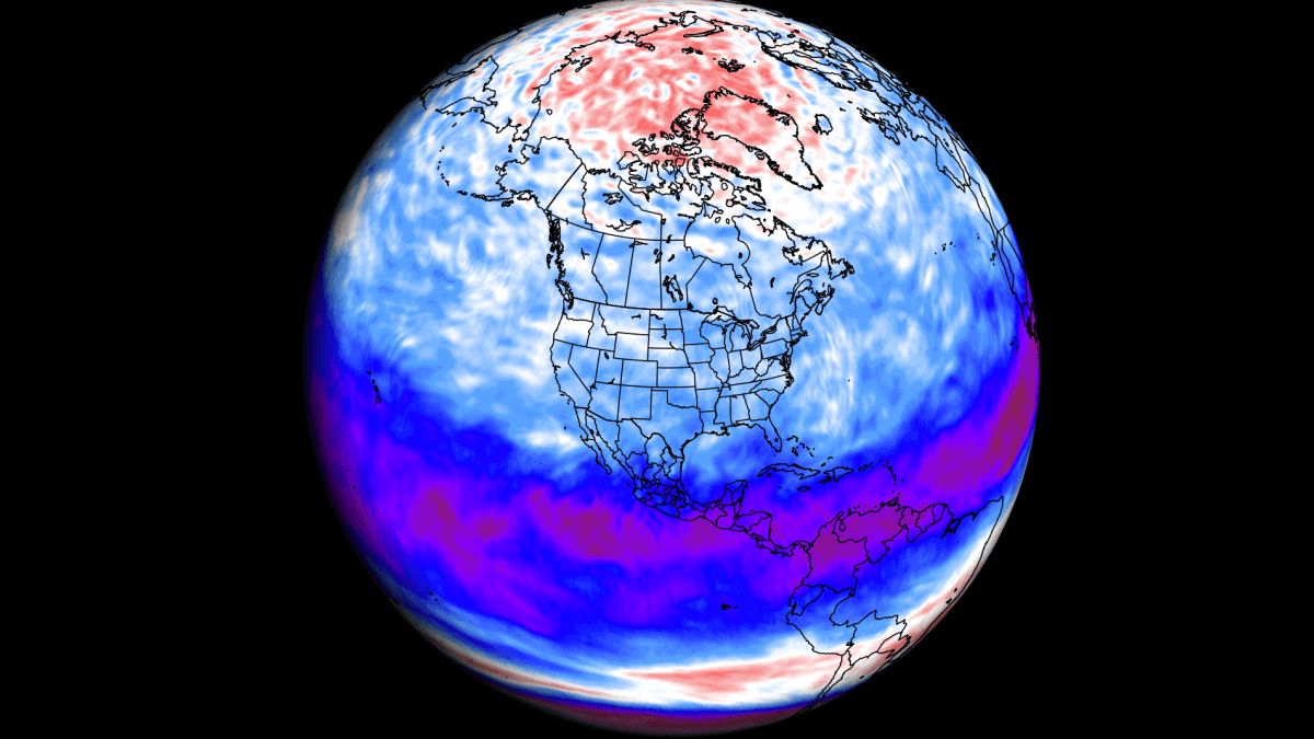
The polar circulation behaves like a very large cyclone, covering the whole north pole and expanding to the south into the mid-latitudes. This Polar Vortex shapes our weather daily, as it is the whole hemispheric circulation.
The image below shows a typical example of the stratospheric Polar Vortex at around 30km/18.5miles altitude (10Mb level) around the middle stratosphere during the winter season.
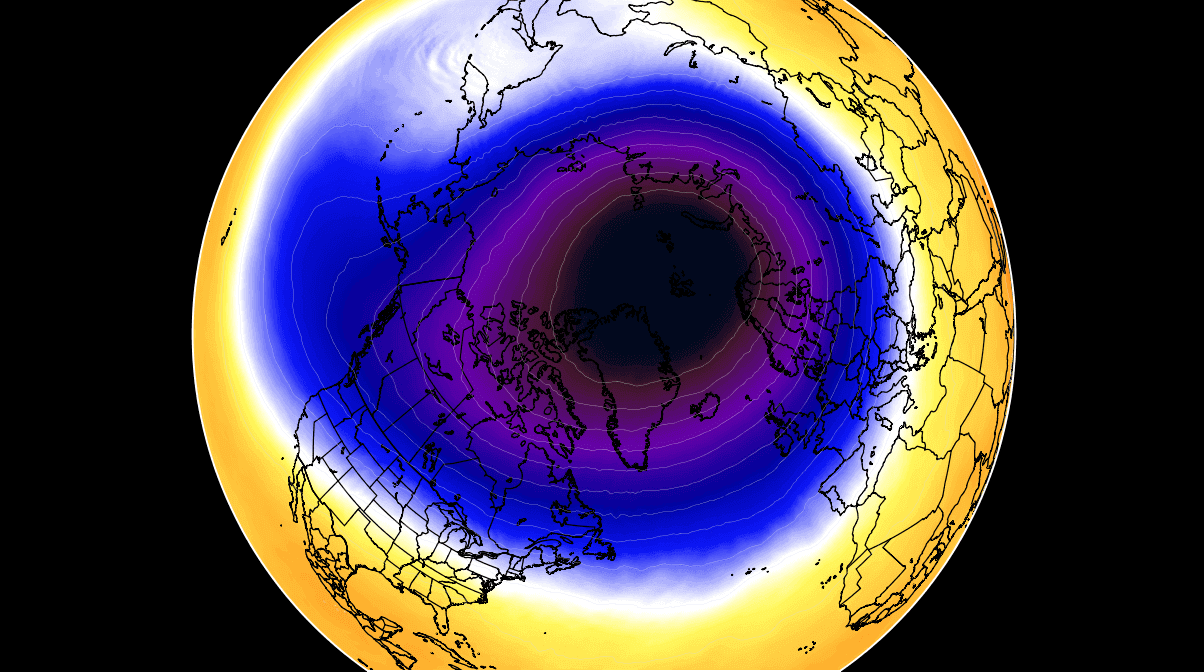
The system in the image is just the stratospheric part of the Polar Vortex, but it is connected down, and any changes in the stratosphere usually reflect in the lower parts and our weather.
We monitor any Polar Vortex activity because it can affect weather across the entire Northern Hemisphere. And it can impact the weather differently, depending if it is weak or strong.
A strong Polar Vortex usually means strong polar circulation. This locks the colder air into the Arctic Circle, creating milder conditions for most of the United States and Europe.
In contrast, a weak Polar Vortex creates a weak jet stream pattern. As a result, it has a harder time containing the cold air, which can now escape from the polar regions into the United States and Europe—Image by NOAA.
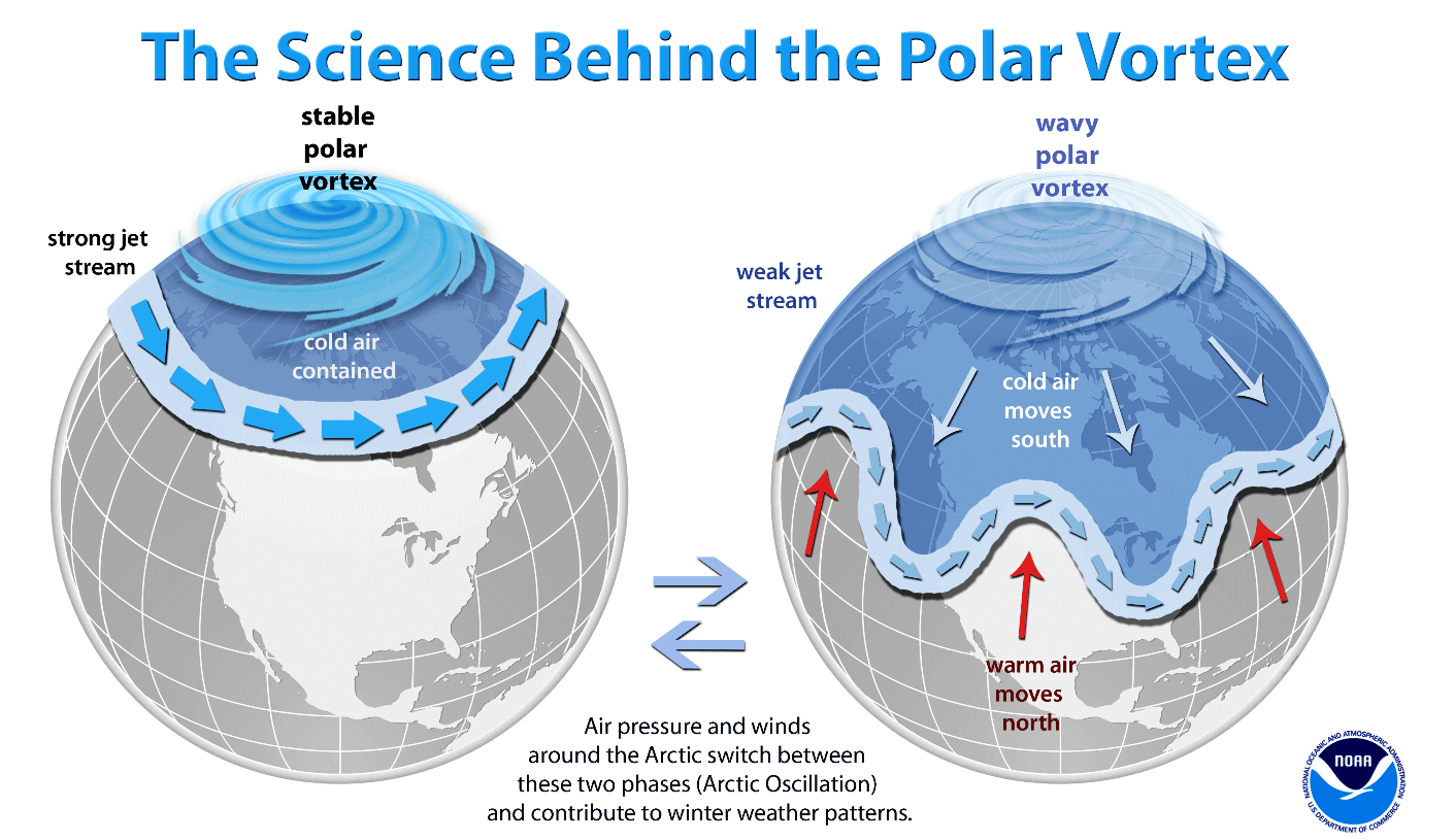
This is the reason why we monitor large-scale atmospheric and oceanic phenomena, as they can have a strong influence on winter circulation. And by changing the winter circulation, they affect the amount of cold air and snow you can see across the United States, Canada, and Europe.
To put the Polar Circulation into perspective, we produced a high-resolution video below, showing the Vortex spinning over the Northern Hemisphere in the Stratosphere at the 30mb level, around 23km/14miles altitude.
The video mainly shows that the Polar Vortex is a large cyclonic area spinning throughout the Northern Hemisphere. It extends from the ground up to the top of the Stratosphere and beyond, reaching over 50km/31miles in altitude.
IT STARTS IN THE OCEAN
Starting at the lowest point, we go to the surface of the Ocean. In the tropical Pacific, we can find a large anomaly that is well known to many and also has a strong weather influence all year round.
That is the ENSO region, which we have mentioned many times now. The image below shows the ENSO regions across the tropical Pacific, with the central (3.4) region being the main one. In these regions, we monitor the ocean surface temperatures and their departure from the average.
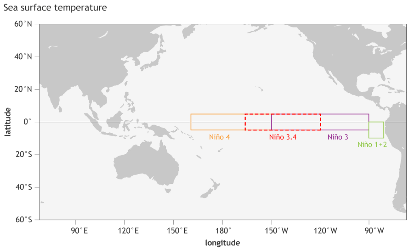
The warm ENSO phase is called El Nino, and the cold phase is called La Nina. A new (cold/warm) phase usually develops between late Summer and early Fall. The cold and warm phases mean that the ocean temperature in the ENSO regions is significantly warmer or colder for a prolonged time.
Each ENSO phase influences the pressure and weather in the tropics differently. This affects the overall global circulation over time, changing the weather patterns worldwide.
A typical phase lasts from late Summer till next Spring, but some events can last up to two or three years. The last phase was a cold La Niña, and it spanned three years, with an El Nino now being forecast for 2023/24.
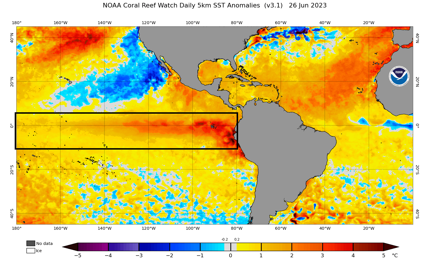
Looking at the latest analysis, we can see the ENSO regions being warmer than normal. This is the rapidly developing El Nino (warm phase), forecast to have a seasonal weather influence on the Fall and Winter weather patterns in the 2023/24 season.
The image below from NOAA Climate shows the typical circulation during an El Niño event, which will be the dominant phase for at least the next ten months.
Rising air in the eastern Pacific causes more storms and precipitation and lowers the pressure over that region. At the same time, the air is descending in the western Pacific, causing stable weather and high-pressure conditions.
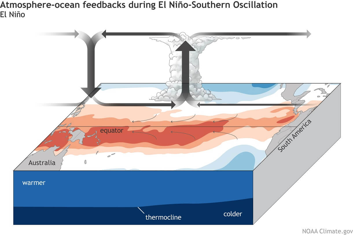
This way, ENSO strongly impacts the tropical rainfall and pressure patterns, affecting the ocean-atmosphere feedback system. Through this ocean-atmosphere system, the ENSO influences the weather globally.
But El Nino is just one large factor that will play its role. As mentioned in the intro, there is large-scale seasonal driver, this time high in the atmosphere but still very much connected to the oceanic El Nino.
…AND ENDS IN THE ATMOSPHERE
This large-scale factor that we mentioned is a strong wind anomaly high over the tropics. That anomaly is called the Quasi-Biennial Oscillation (QBO), also known as the “heartbeat of the Atmosphere,” as it is so regular.
The Quasi-Biennial Oscillation (QBO) is a regular variation of the winds high above the Equator. Strong winds in the stratosphere travel in a belt around the planet, and around every 14 months, these winds completely change direction.
This means that winds high above the equator change from west to east every year or so. We must look at the winds over the entire planet to see it, from the south to the north pole.
We produced a unique image below from the latest analysis data. It shows the analysis of west-to-east (zonal) winds over the entire earth, from the south pole (left side), over the Equator to the north pole (right side). Basically, it is like looking through the entire atmosphere.
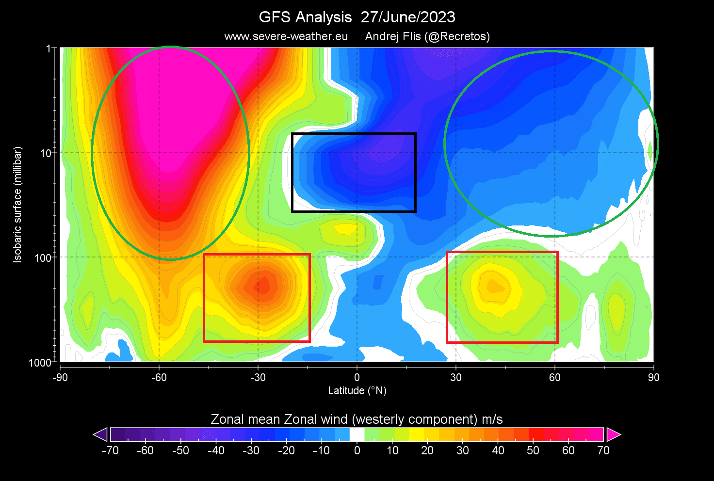
Positive values indicate westerly winds, while negative values indicate easterly winds. The graphic shows the winds from the surface up to around 48km/30miles altitude. We have marked a few areas of interest that really stand out.
- Green circles: This shows the very strong stratospheric winter circulation over the southern hemisphere. This is associated with a strong stratospheric polar vortex over the South Pole. In the Northern Hemisphere, the stratospheric circulation is reversed as it is in the summer mode.
- Red boxes: This is the normal jet stream as we know it. You can see that the jet stream is currently stronger over the Southern Hemisphere as it is in Winter mode. You can also see how it connects with the much stronger stratospheric circulation above, typical for Winter.
- Black box: This is a strong area of negative values (easterly winds). It is more important than it might look at first. This shows the Quasi-Biennial Oscillation (QBO) above the Equator, a regular shift in wind direction from west to east, currently starting in the east (negative) mode.
THE HEARTBEAT OF THE ATMOSPHERE
Now that you know what QBO is and where it is, we can look at some analysis and forecast maps to understand how it works.
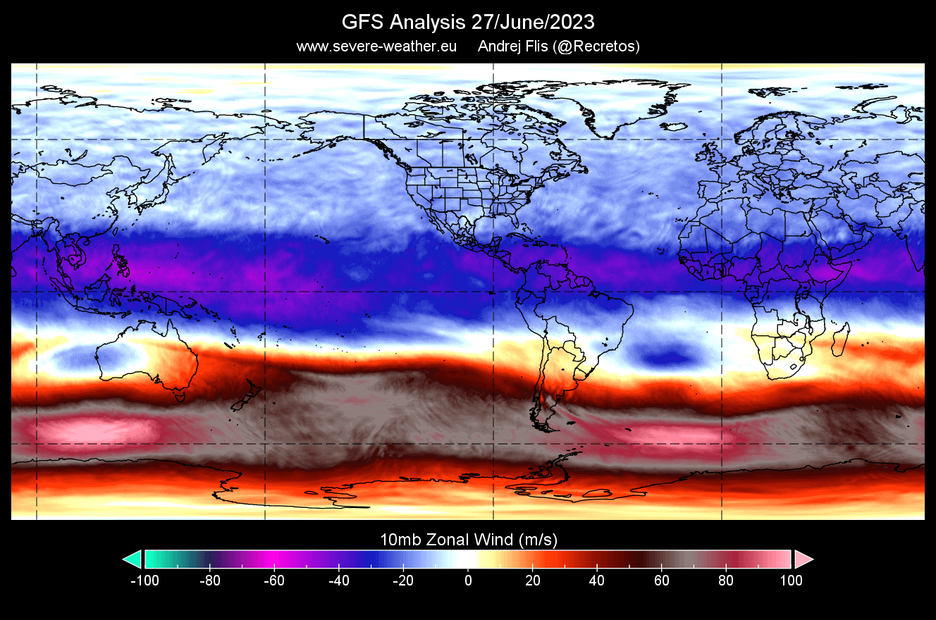
A wind analysis below for the 10mb level (30km/18.5miles) shows this easterly wind stream above the tropical regions. It is currently in negative values, which reveals that easterly winds are prevalent. This means that the QBO is in the east (negative) mode.
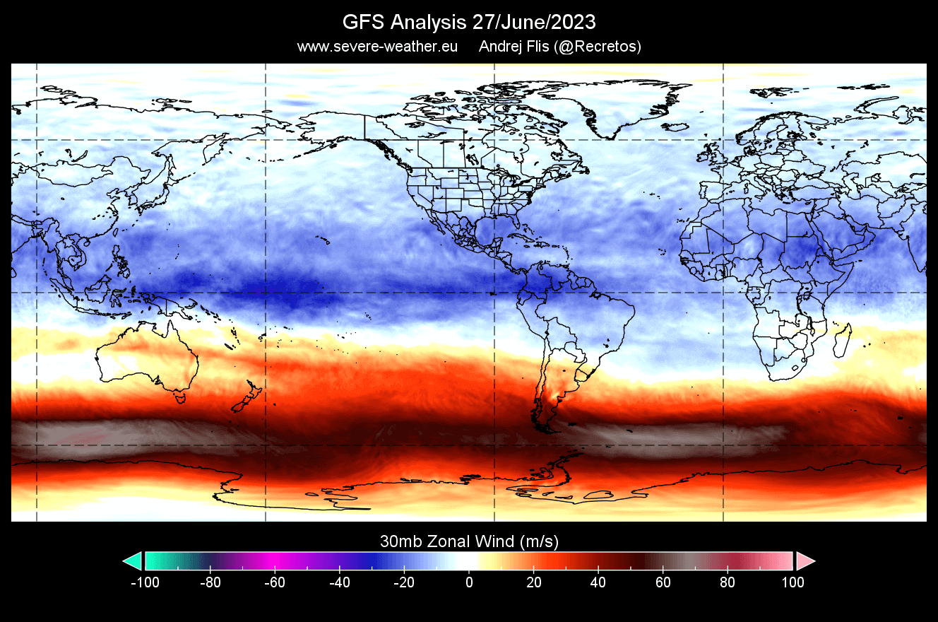
A wind analysis below for the 30mb level (24km/15miles) shows weaker easterly winds over the Equator. This is because the QBO is descending over time. So going into late summer, the easterly winds at this level will strengthen as they descend down from the higher levels.
Looking more closely at the past three years, we can see how each phase descends over time. A west QBO phase was active for the 20/21 winter season, a negative phase in 21/22, followed by a positive last winter, and the new negative starting to descend down for Winter 23/24. The image below is a NASA analysis.
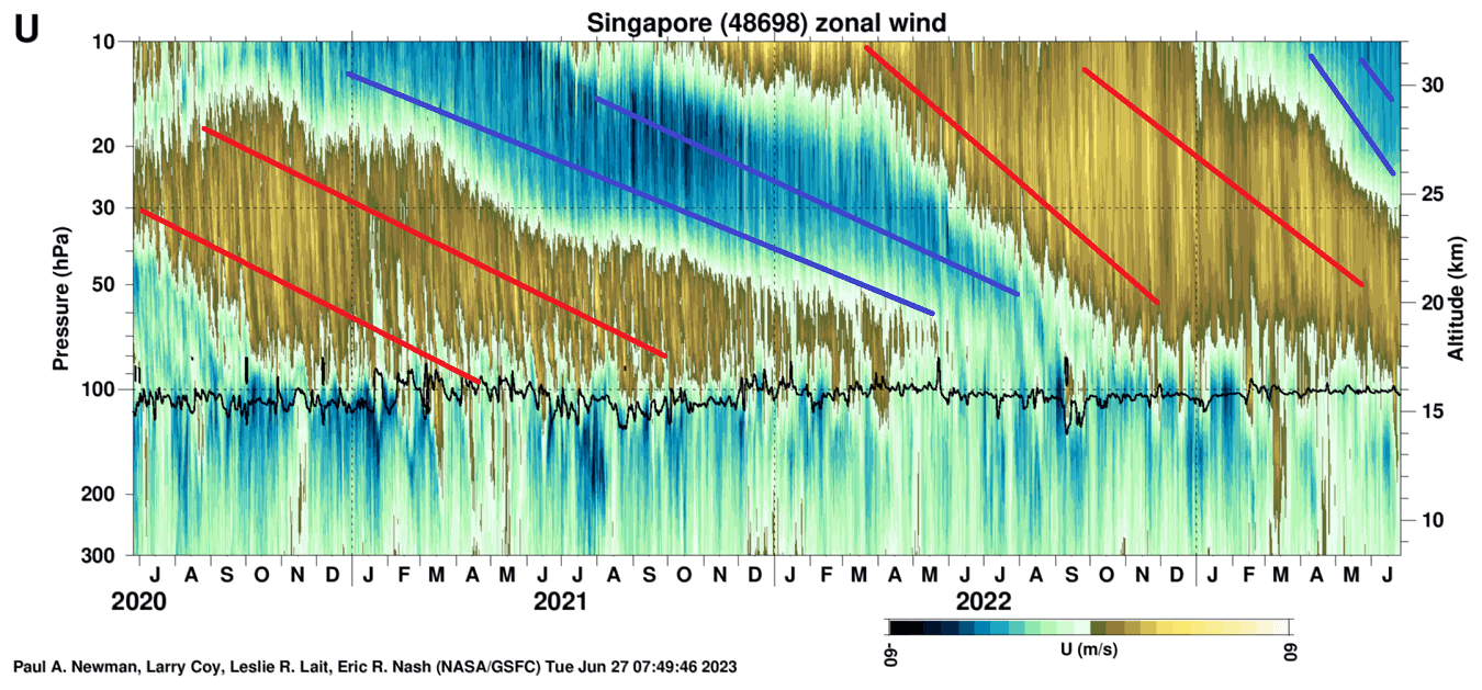
If we look specifically at 2023 so far, there is a very obvious fast descent of the easterly winds. It accelerated in early Spring and continues to this day. It will continue to descend all the way towards Winter 2021/2022, being replaced by a westerly phase in 2024.

A radiosonde analysis from Singapore also shows the wind direction above the tropics. It reveals the easterly winds around the 10-30mb level, confirming the east QBO phase is descending and will be dominant this Winter.
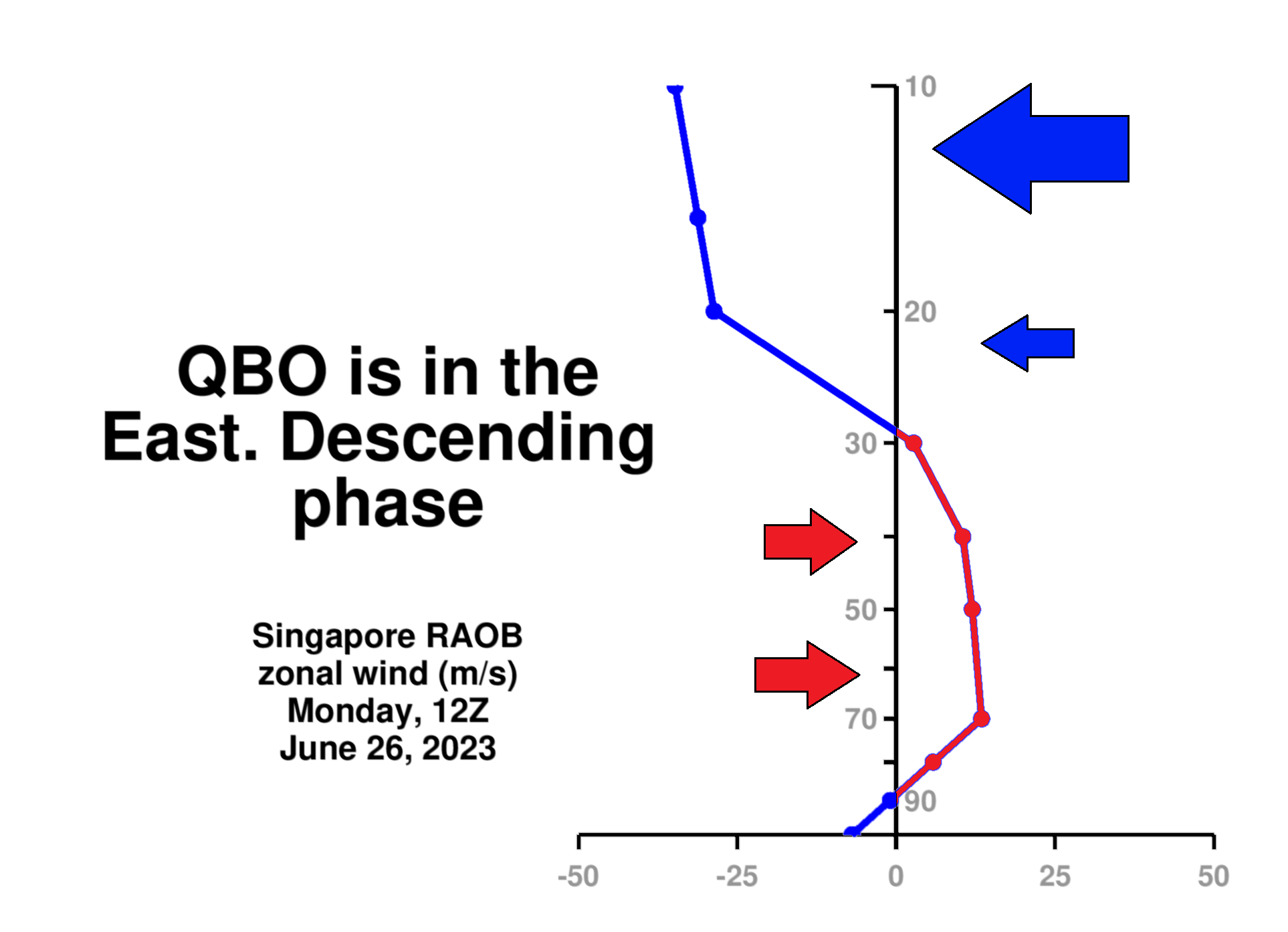
This shift from west to east winds is so regular that it gave QBO the nickname “heartbeat of the atmosphere“. Each phase slowly descends over time, from the middle stratosphere around 10mb (~30km/18.5miles) down to the top of the troposphere around 100mb (~17-18km/11miles).
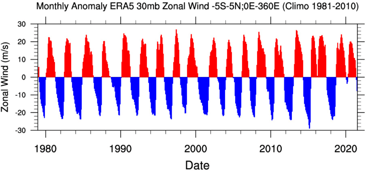
Below we have a special graph that shows the zonal wind anomalies for the past 40 years at around 24km/15mi altitude. It nicely shows just regularly this wind shift really is, like watching a heart pulse, shifting from one phase to another.
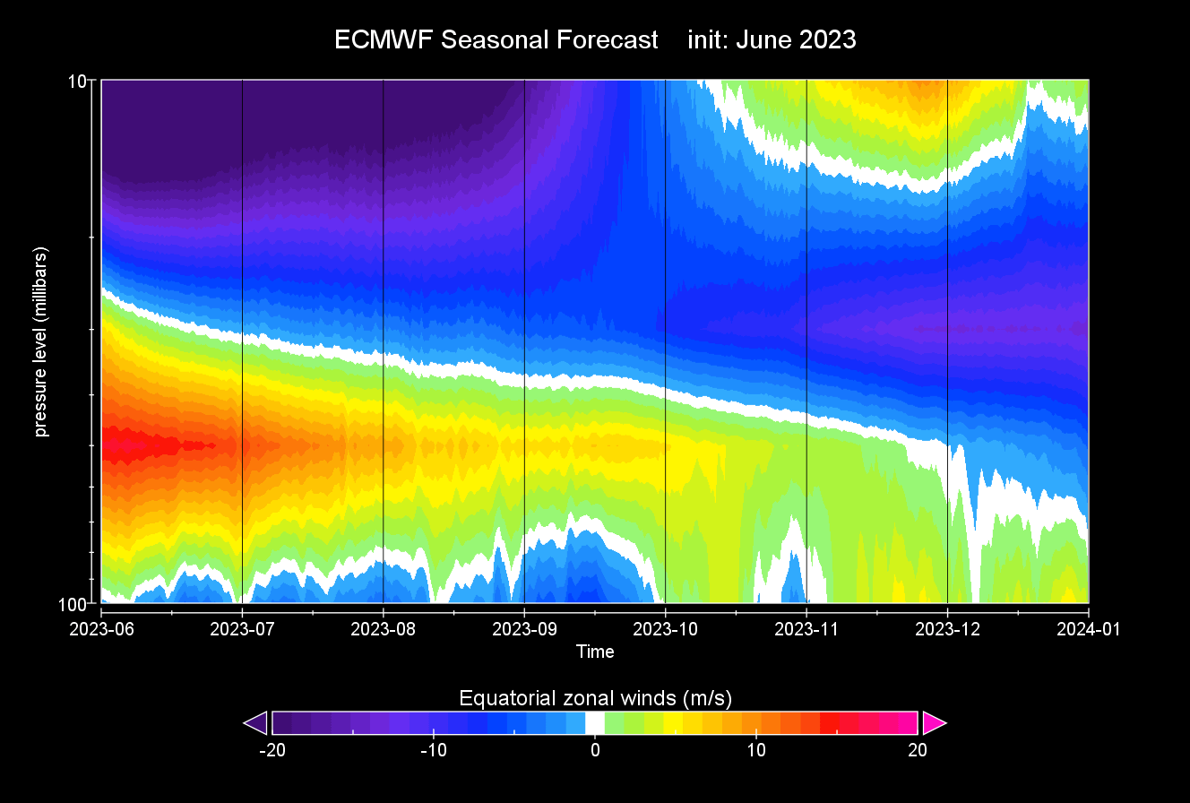
We produced an image from the latest ECMWF seasonal forecast data. Below is the forecast for the QBO, showing global zonal winds over the Equator. Notice the east QBO descending further down as we go into Fall and Winter. This forecast confirms that a mature negative QBO phase will be in place for the 2023/24 Winter season.
So to summarize, the QBO is the wind phase in the tropical stratosphere, pulsing between the easterly and westerly phases. That is all well and good, but how do these phases actually influence the winter weather?
QBO AND WINTER WEATHER
The QBO is an important part of weather development in Winter, as it can affect the polar jet stream. The power and direction of the winds in the polar jet stream can change with the QBO. The jet stream is an important atmospheric feature that shapes our weather.
Depending on the QBO, the risk of winter conditions across the Northern Hemisphere can differ by each of the phases:
- When the QBO is negative (easterly), there is an increased chance of a weaker jet stream, sudden stratospheric warming events, and colder winters in the United States, Canada, and Europe.
- When the QBO is positive (westerly), the chance increases for a stronger jet stream and polar circulation. That means a milder winter, as the colder air is locked in the polar regions, having a harder time punching out of the strong circulation.
There is more than one reason why QBO can influence our Winter weather. One very important aspect is, of course, the Polar Vortex. That is what we first discussed in this article, talking about winter circulation. The image below shows the connection between the east QBO and the Polar Vortex in the December-January winter period.
It might seem complicated, but the main takeaway is that the QBO helps with the overall tropical forcing, including the ENSO. That is why a QBO does not mean a fixed weather situation, as an east QBO response can be different during a La Nina or an El Nino.
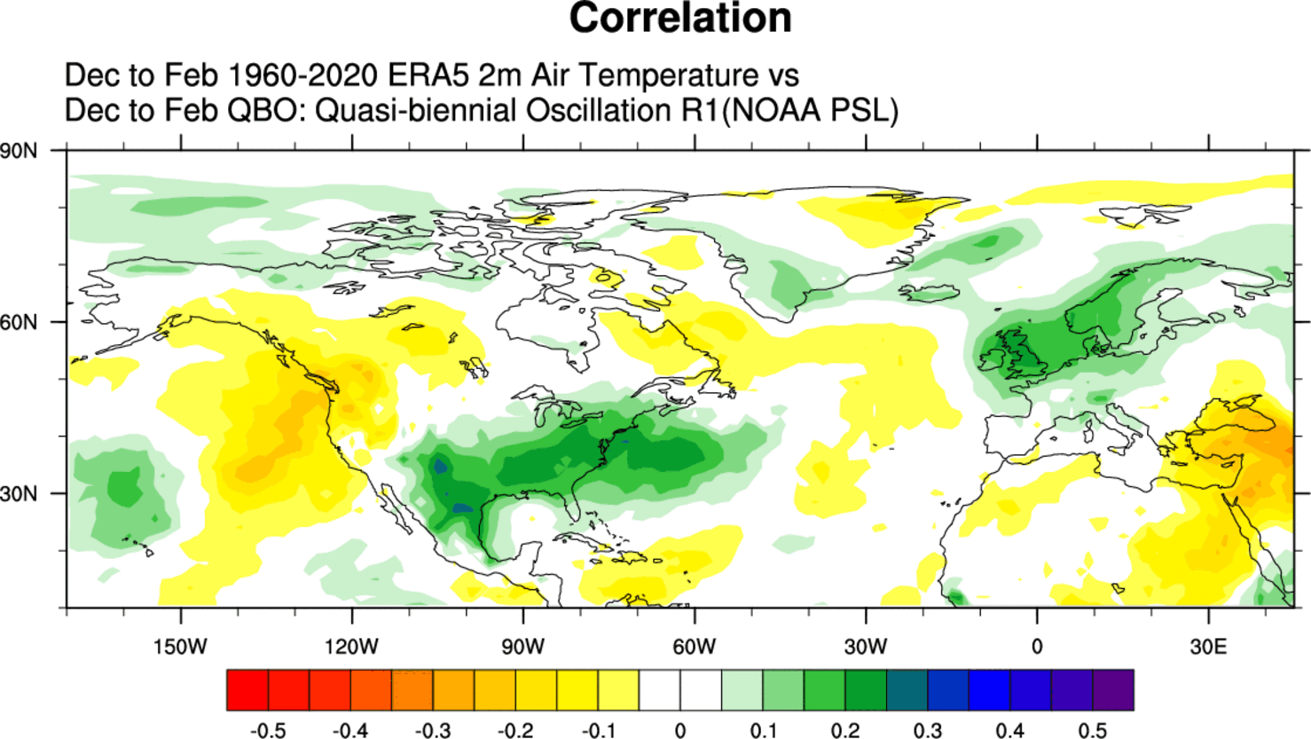
The images below show the correlation between the QBO and surface temperatures in the Winter season. More specifically, this shows the signal for the Easterly QBO, which we will have this Winter.
Correlations do not show the actual end result but are more of a guidance when searching for signals. There are many influences on top of El Nino or QBO, so the signal is never perfect but only serves as guidance.
Looking at winter pressure anomalies first, you can see a tendency for lower pressure in the southern and eastern United States and over Europe in a negative QBO phase. Higher pressure is present over Canada and the Pacific Northwest.
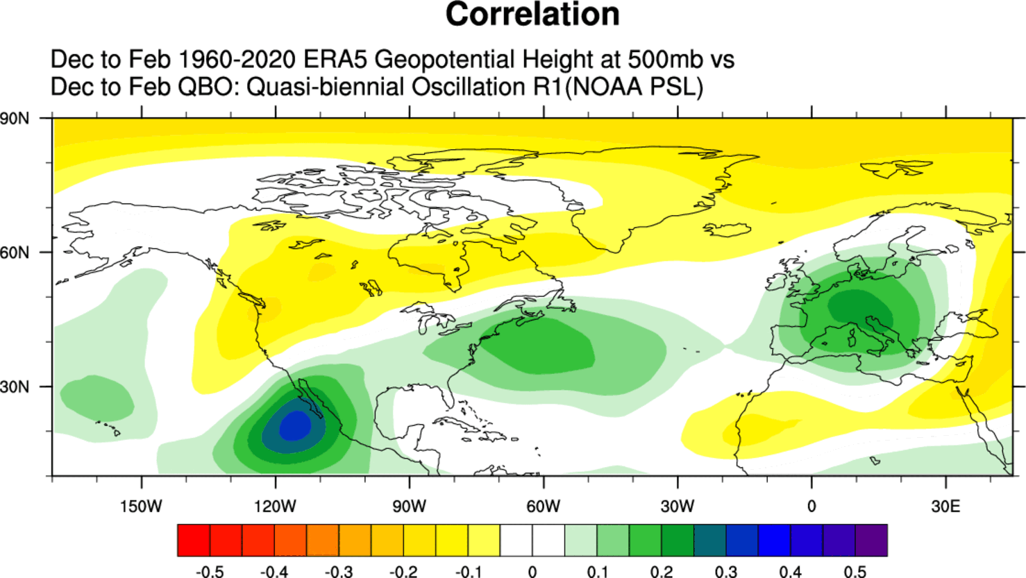
This shows a tendency for a negative NAO pattern in the Atlantic and a more disrupted (wavey) jet stream. A disrupted jet stream means an easier way for the colder air to escape the polar regions.
Below you can see a tendency for colder temperatures over the southern and eastern United States and Europe. The signal is not overly strong, as there are a lot of other “winter influencers” out there.
There is more than one reason why QBO can influence our Winter weather. One very important aspect is the stratospheric Polar Vortex, which we discussed in the first segment. The image below shows the connection between the east QBO and the stratospheric Polar Vortex in the December-January winter period.
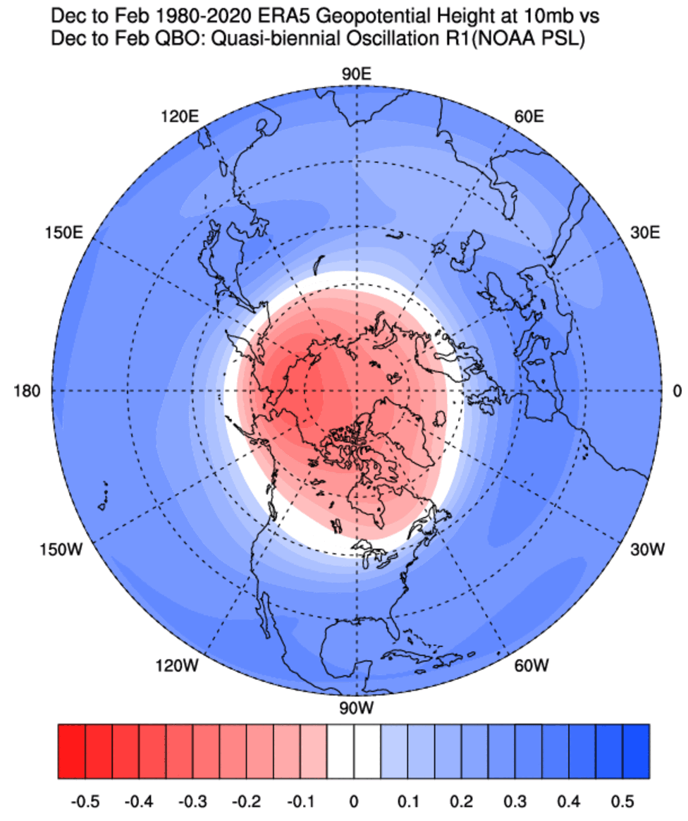
We can see a signal for a higher pressure over the polar stratosphere, which indicates a weaker Polar Vortex and a weaker stratospheric winter circulation.
That is usually associated with Sudden Stratospheric Warming (SSW) events. These powerful weather events occur high up in the Polar stratosphere but usually come crashing down, impacting the weather across the entire Northern Hemisphere.
That can also be seen in the stratospheric temperature correlation. It indicates warmer stratospheric temperatures in an easterly (negative) QBO phase over the polar regions.
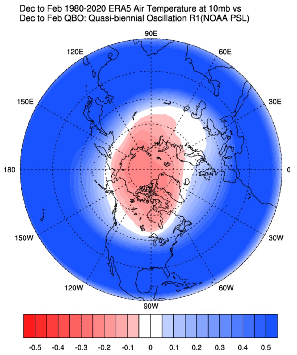
A proper Polar Vortex collapse event (Sudden Stratospheric Warming) basically means a strong temperature and pressure rise in the Stratosphere and a resulting collapse of the Polar Vortex circulation.
There is one major condition for a disruption event to be classified as a Sudden Stratospheric Warming event or a full collapse. The stratospheric winds, which are mostly westerly in Winter, must be reversed to easterly.
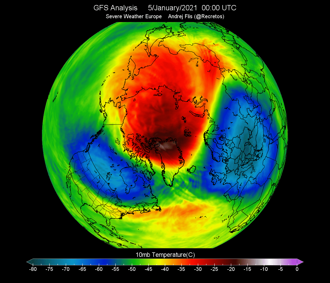
One such major event was recorded in early January of 2021. Below you can see the temperature in the mid-stratosphere as the Sudden Stratospheric Warming event was in progress. The temperature wave fully spread over the North Pole, splitting the Polar Vortex and breaking its circulation.
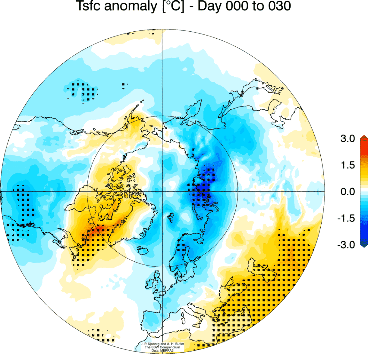
But what does such an event mean for our everyday weather at the surface? Well, you have to understand that it takes some time for the effects from the Stratosphere to reach the lower levels. That is why we usually look at the 0-30 day periods after such an event to identify the weather changes.
The average temperature of 0-30 days after a Polar Vortex collapse event shows that most of the United States is typically colder than normal, along with Europe. Note: this is an average picture of many SSW events. Each stratospheric warming event is different and does not automatically mean a strong winter pattern.
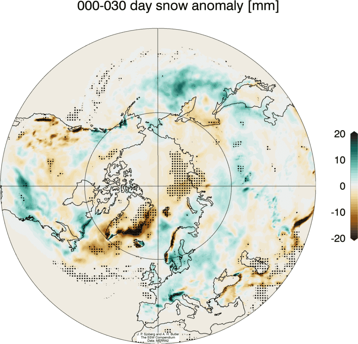
Looking at the snowfall below, we can see above-average snowfall over much of the eastern United States and Europe. Again, this is an expected response, as typically, after major stratospheric warming, the colder air has an easier path towards the south and into these regions.
So as you can see, having a strong or weak Polar Vortex can significantly change Winter weather in the United States, Canada, and Europe. For this reason, we closely monitor the weather patterns and all activity surrounding the Polar Vortex.
So if we summarize, we can see that the QBO is a stratospheric phenomenon and impacts the Winter stratospheric Polar Vortex. Influencing the stratospheric Polar Vortex can indirectly affect the surface winter weather, as it changes the winter circulation and the jet stream.
But, as we mentioned, the QBO has to compete with El Nino and other global factors, so it has a weaker signal when looking at the large-scale data.
So let’s quickly look at how El Nino will influence the Winter 2023/24.
EL NINO SEASON 2023/2024
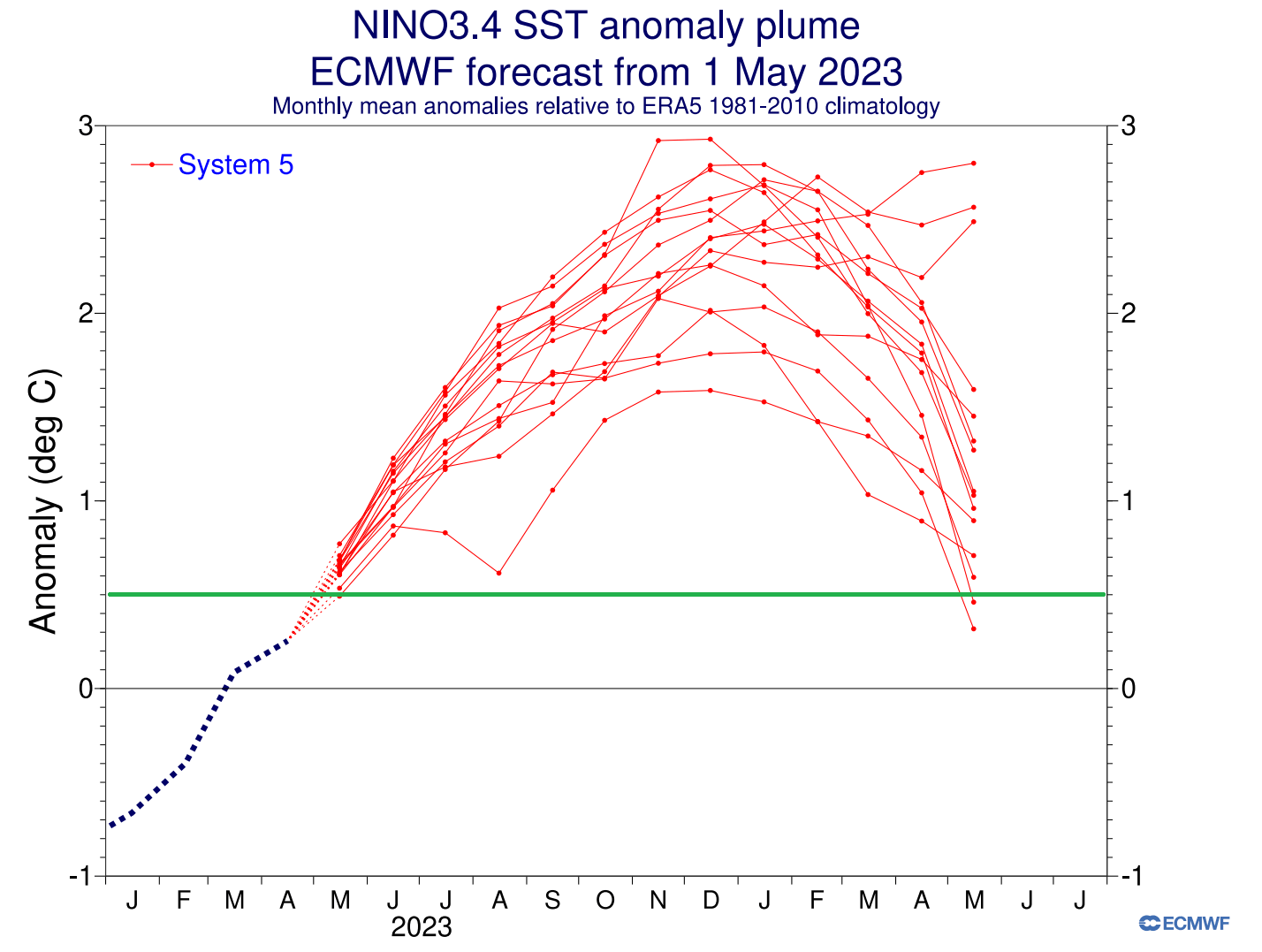
Looking first at the extended seasonal ENSO forecast from ECMWF, you can see the ensemble consensus for a rather strong El Niño event. The green line is the El Niño threshold (+0.5 degrees). The anomalies are forecast to peak into the strong territory, lasting into early Spring of 2024.
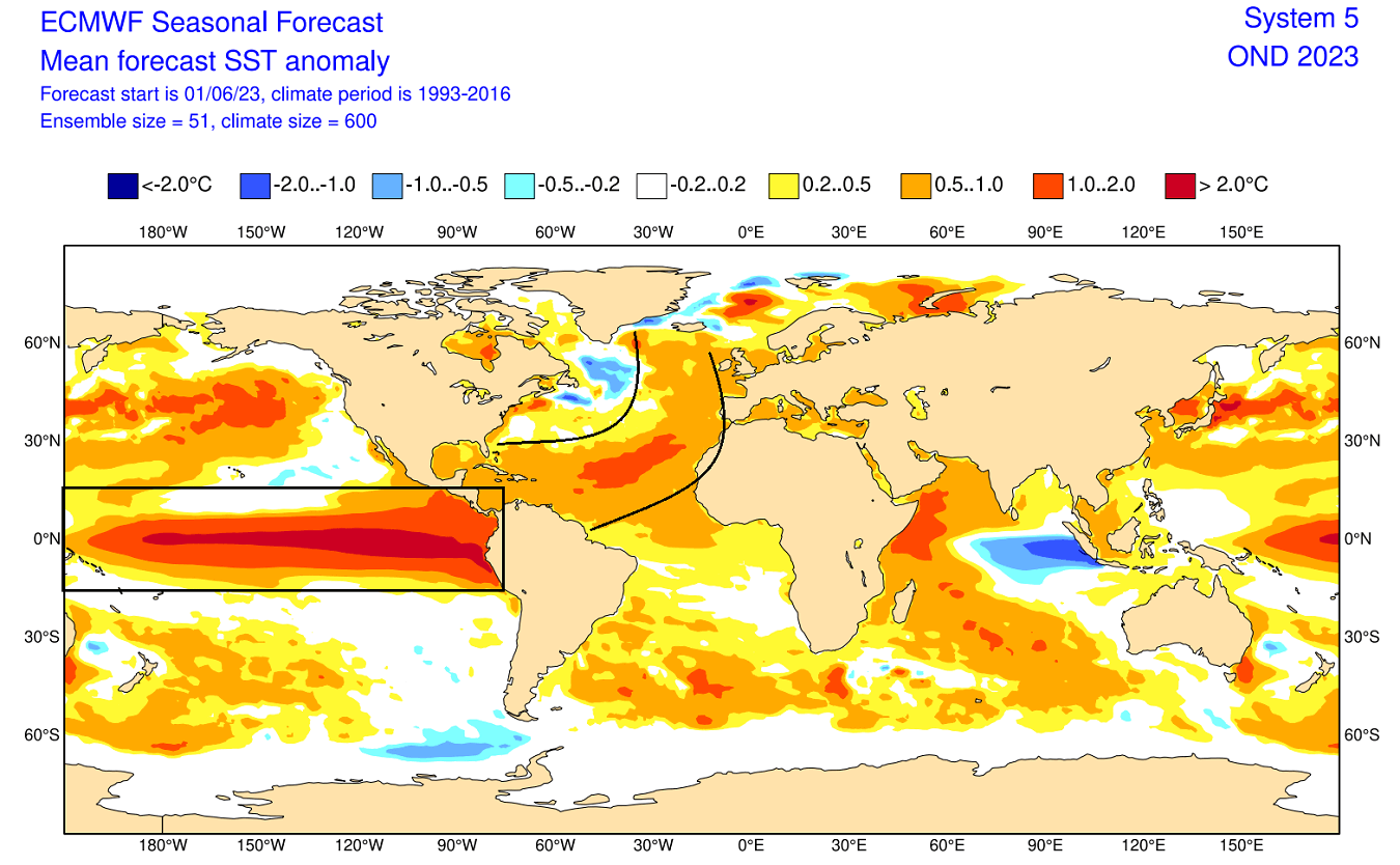
The ocean anomaly forecast for October-December shows a strong El Niño event expanding across the entire tropical Pacific. Another area of interest is the unusually warm ocean area in the North Atlantic, which can also play its role in the grand weather picture.
During the El Niño winter season, there is typically a strong and persistent low-pressure area in the North Pacific. That pushes the polar jet stream further north, bringing warmer-than-normal temperatures to the northern United States and western Canada.
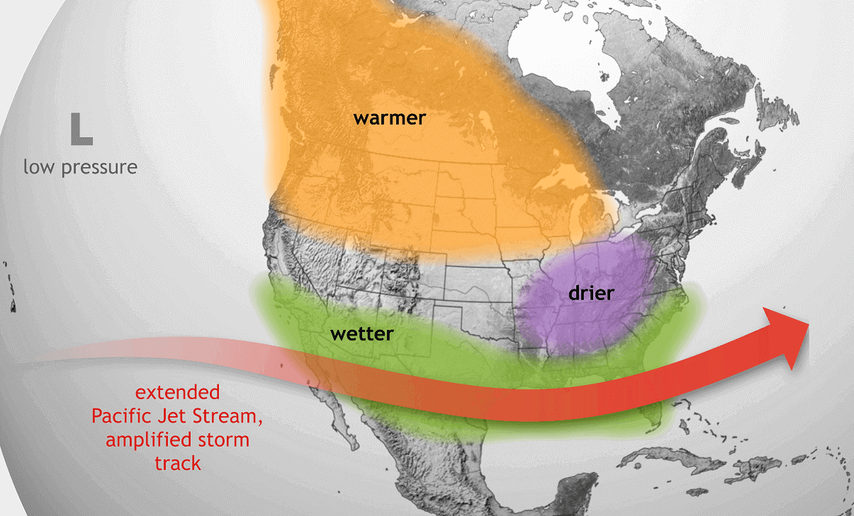
But the southerly Pacific jet stream is amplified during an El Niño, bringing storms with lots of precipitation and cooler weather to the southern United States.
EL NINO AND QBO
As mentioned before, the QBO and El Nino can work together to create a specific winter pattern. But not through the same path. There is even a difference between a west or east QBO during an El Nino event.
For this reason, we combined the data of all the El Nino events in the past 45 years and sorted them by QBO phases. We subtracted the El Nino years with west QBO phases from the east QBO years.
Below are images of how the east QBO can amplify or change the original El Nino pattern across the United States, Canada, and Europe.
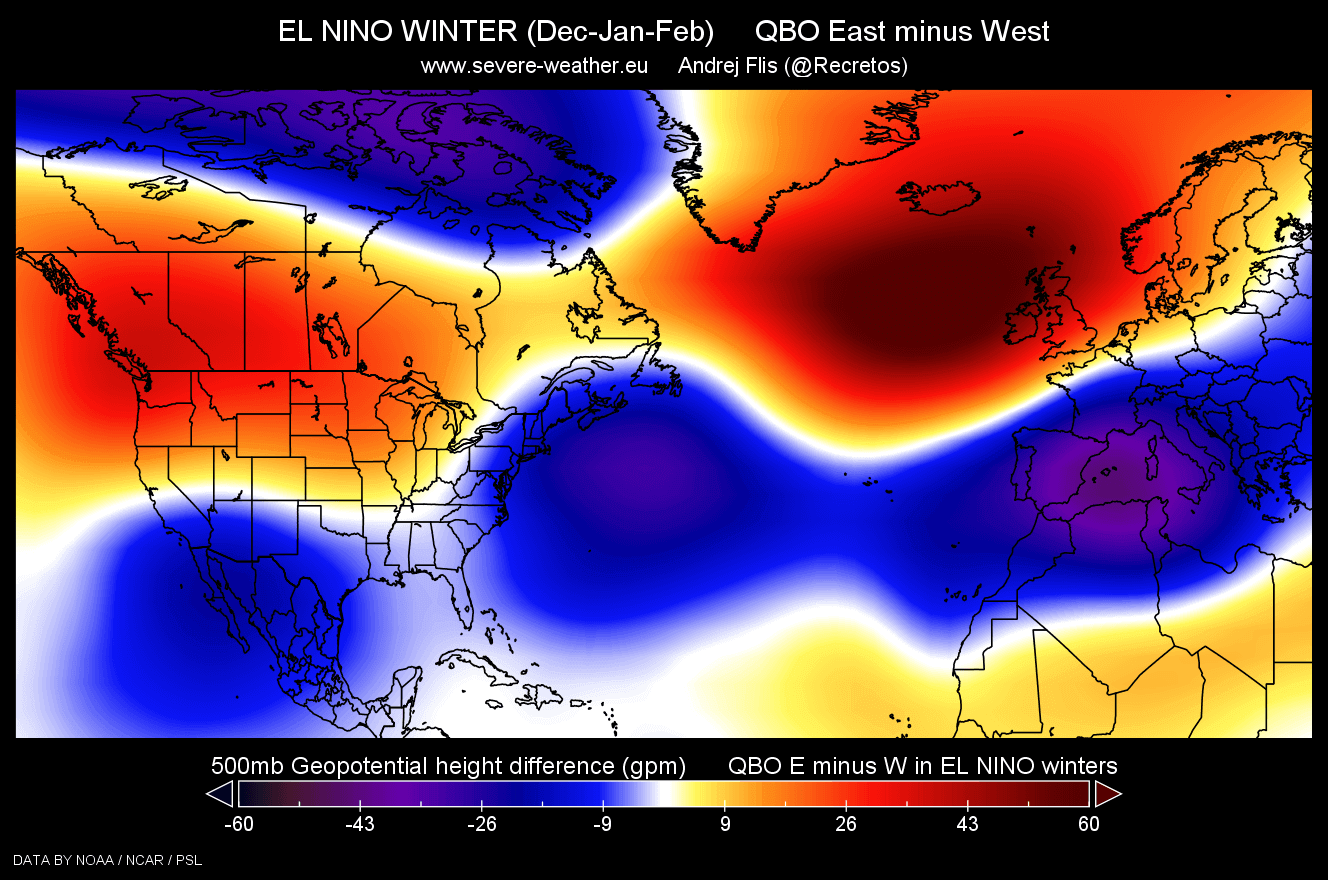
Looking at pressure anomalies first, we can see that an east QBO in an El Nino winter has a stronger high-pressure signal in the North Atlantic, western Canada, and the northern United States. As a response, you can see lower pressure over the southern and northeastern United States and Europe.
The temperature response is similar. We see colder air over the southern United States and also over the northeastern United States during an El Nino with an east QBO, compared to an El Nino with a west QBO. Colder air tendency is also seen over much of Europe.
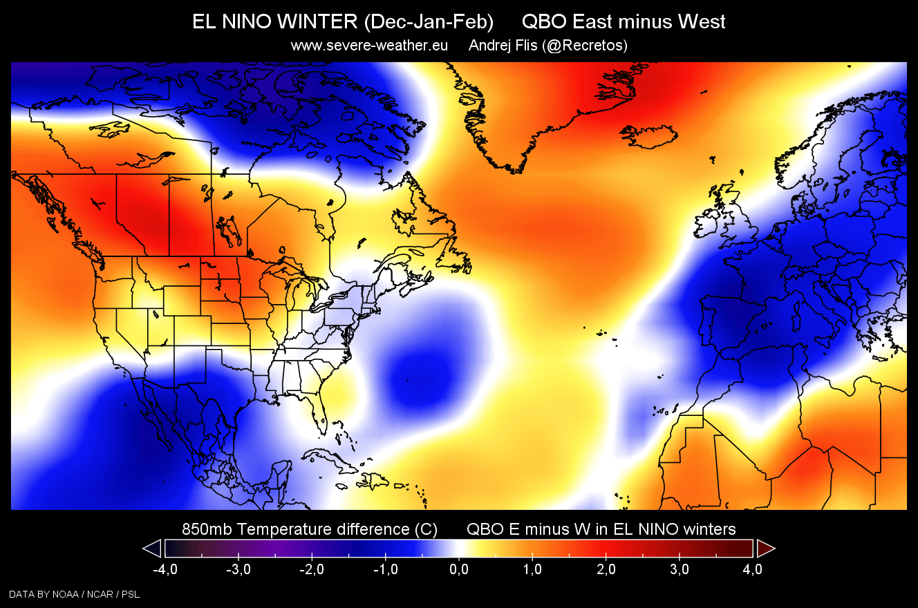
This likely links back to the increased tendency of a Sudden Stratospheric Warming event during an east (negative) QBO Winter.
The Canadian CANSIPS model already has the Winter 2023/24 season in its forecast range. This is not an official forecast or anything of great importance because, at this range, it is only used as an idea or a developing trend. It is useful to see how the models are calculating all the factors combined.
Below you can see the Winter 23/24 pressure pattern forecast, which shows the expected pattern of a high-pressure system over Canada and the polar regions. Around it are low-pressure systems, similar to what we are seeing in the historical data for El Nino, combined with a negative QBO phase.
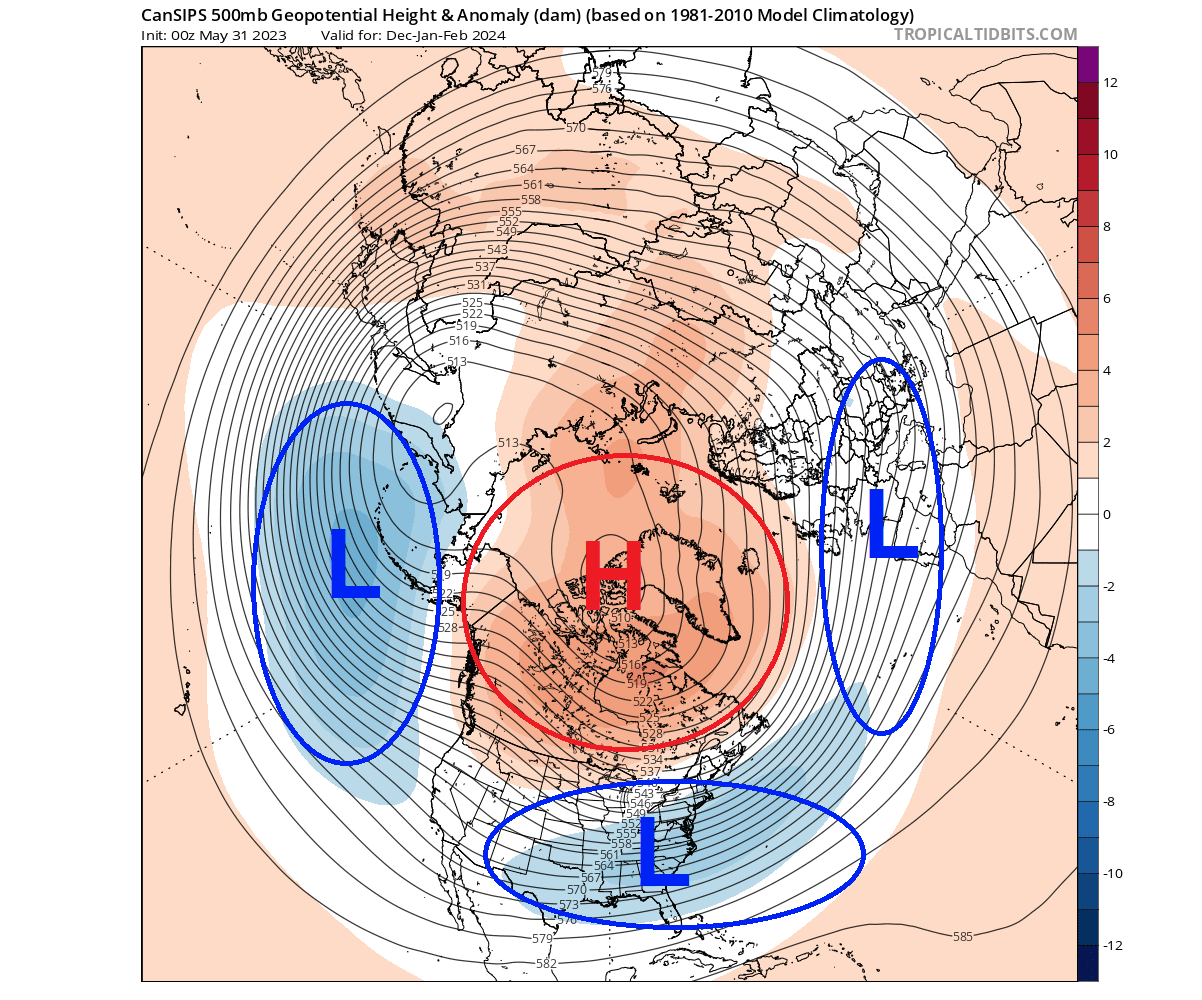
This is also a typical pattern following Sudden Stratospheric Warming events. So there does seem to be some linkage already detected in the modeling solutions, combining all the currently known effects to produce a weaker polar Winter circulation.
SUMMARY
We now know what the Polar Vortex is, what the QBO is, and what an El Nino is. But how is it all related? The QBO is a wind anomaly in the stratosphere above the Equator and is connected to the large-scale global circulation.
The west (positive) or east (negative) phase of the QBO can have a different effect on the polar vortex and the development of a Stratospheric Warming event. In most cases, the east phase of the QBO is more favorable for a better winter pattern.
It supports a Stratospheric Warming event, which can significantly change the overall polar circulation. Combined with an El Nino, this increases a tendency for colder temperatures over the south-central United States and potentially more snow over the northeastern United States.
A colder signal is also emerging from historical data for Europe. But as mentioned, an east phase of the QBO and an El Nino does not automatically guarantee a colder winter in the mentioned regions. But as history shows, it increases the potential for a better winter season overall.
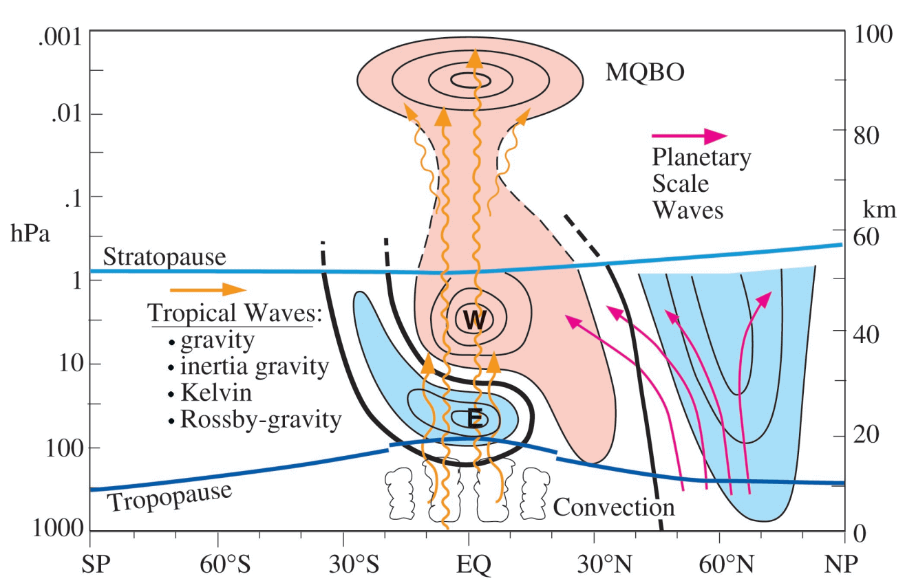
The image below from a QBO study shows a combination of El Nino, east QBO, and low sea ice extent. Marked in the yellow box is the Polar winter circulation in the stratosphere over the Northern Hemisphere. You can see that the combination of an El Nino, negative (east) QBO, and low sea ice produces a weaker winter polar circulation.
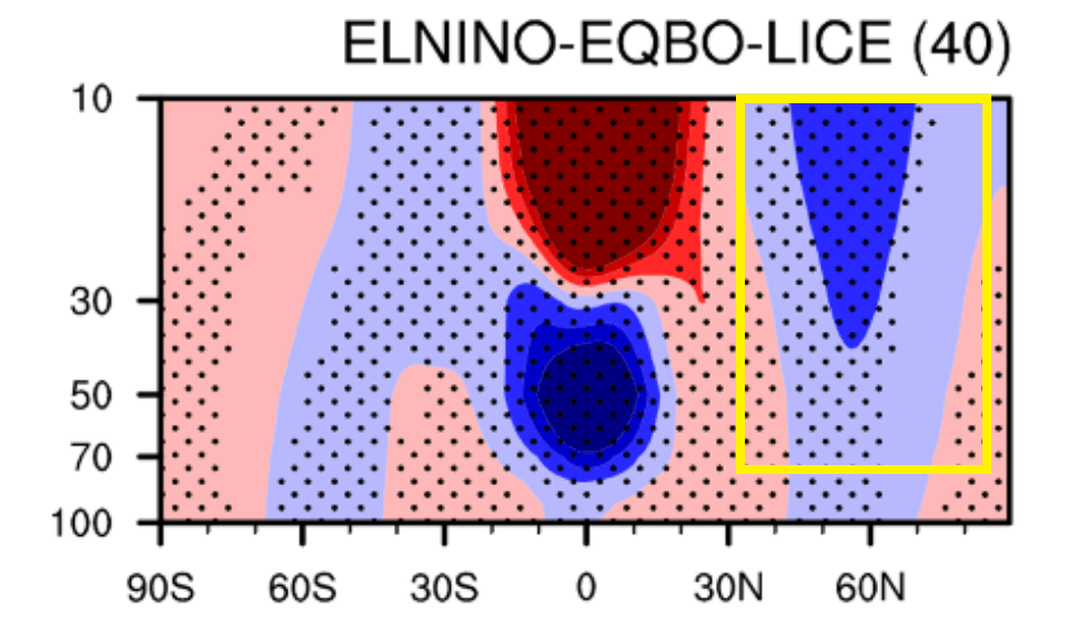
A weaker polar circulation means that the chance of Sudden Atmospheric Warming increases, and with it, a chance for circulation collapse and cold air release into the regions of the United States and Europe.
The next image below is from an SSW Study, showing the number of events for the QBO phase, ENSO phase, etc.
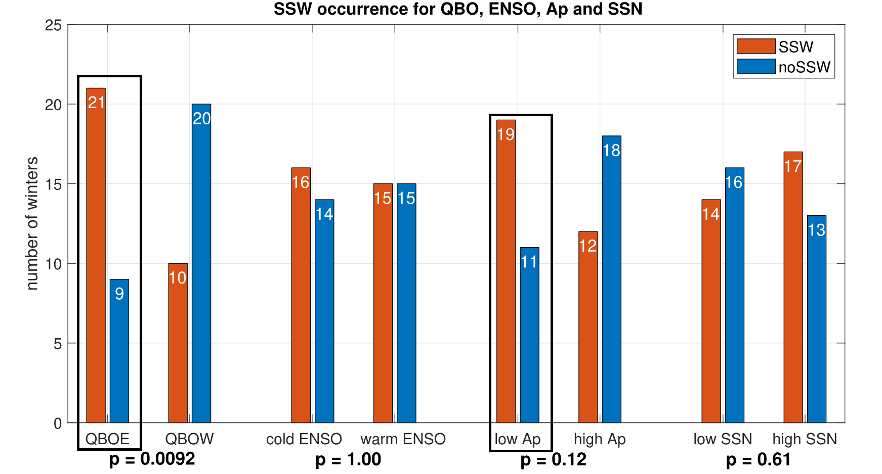
You can notice that the east (negative) QBO has a far higher frequency of SSW events than the west (positive) QBO phase. ENSO is somewhat neutral in this regard. So, the oceans and the atmosphere are gearing up for a very dynamic Winter season 2023/24, but we do not yet know many of the details that fill in the big picture.
We will keep you updated on the global weather pattern development, so bookmark our page. Also, if you have seen this article in the Google App (Discover) feed, click the like button (♥) there to see more of our forecasts and our latest articles on weather and nature in general.
Don’t miss:
Exploring the Powerful El Niño Effect: How to Understand Nature’s Fury for a Better Future