The powerful Arctic Blast is underway across Canada and the United States, spreading south across the continent. This is the most significant this season, thanks to a deep southern lobe of the Polar Vortex emerging aloft. As the cold reaches the Gulf Coast, a Winter Storm Enzo will form, bringing rare snowfall for Houston, New Orleans, and the Florida Panhandle on Tuesday.
The southern lobe of the Polar Vortex has established extremely cold conditions, plunging temperatures into a deep freeze. This will result in temperatures 30-40 degrees below normal for tens of millions across the North American continent Sunday through Wednesday.
As the Arctic Blast continues further south, it further intensifies. On its front edge, a polar and subtropical air mass clash develops a significant Winter Storm Enzo across the deep South U.S., blanketing the Gulf Coast from Houston across New Orleans to Florida Panhandle to eastern Carolinas on Tuesday.
Note: Snow along the Gulf Coast cities is quite rare. Houston, TX, had the last snowfall on February 15th, 2021, when about one inch fell during a winter storm. Notable historical snowfall events for the city are the following:
- 20 inches on February 14-15, 1895 (the most significant snowfall on record)
- 4.4 inches on February 12, 1960
- 2 inches on January 11, 1973
- 1.7 inches on December 22, 1989
- 1 inch on February 15, 2021
New Orleans gets snow even less frequently, as proper conditions for snowfall on the Louisiana coast are rarely met. This can only happen when the most intense Arctic outbreaks occur, bringing a frigid air mass far south into the Gulf Coast region. Even then, a winter storm must form to produce winter precipitation and snow.
Historical data for New Orleans reveal that a small amount of snow fell during the 2004 Christmas Eve snowstorm and again on Christmas Day, when rain, sleet, and snow fell on the city, leaving some bridges icy. Another snowstorm affected the city on New Year’s Eve, 1963, bringing 4.5 inches of snow.
Snow fell again on December 22, 1989, during the intense cold wave, when most of the city received 1–2 inches. The last significant snowfall in New Orleans was on December 11, 2008.
Other cities In Lousiana have the snowfall records as follows:
- Lake Charles – 4 inches on January 11th, 1973
- Baton Rouge – 3.5 inches on January 23rd, 1940
- Shreveport – 7.9 inches on January 19th, 1948
The latest weather forecast suggests that about 4 to 8 inches of snow will blanket the deep South from Houston across New Orleans to southern Georgia so that Winter Storm Enzo could be historic for the region. We will get into more details below.
On Saturday, the Arctic cold pool had already spread across a large part of the Contiguous U.S. Low temperatures, combined with strong northerlies, pushed wind chill temperatures into deep freezing levels.
Wind chill temperatures are the most significant in southern Canada and the northern U.S., ranging from -20 to -40 °F in Alberta, Saskatchewan, Canada, to Montana, Dakotas, and Minnesota, U.S.

The Polar front continues south across the U.S. towards the deep South and will reach the Gulf Coast on Sunday, resulting in a deep freeze for the typically warmer states compared to those farther north. Temperatures along the Gulf Coast will be 20-30 °F below normal on Monday and Tuesday.
The following animation shows the overall weather evolution: the rapid spread of the Arctic air mass across the U.S.
Before we dig into the details of the upcoming event, we want to talk about the main trigger behind these events. The historic Arctic Blasts often follow a substantial disruption of the Polar Vortex aloft.
This month, its southern lobe has shifted over North America, which is why the cold air mass outbreak is so intense and is progressing this far south, reaching the Gulf Coast as well.
What is the Polar Vortex?
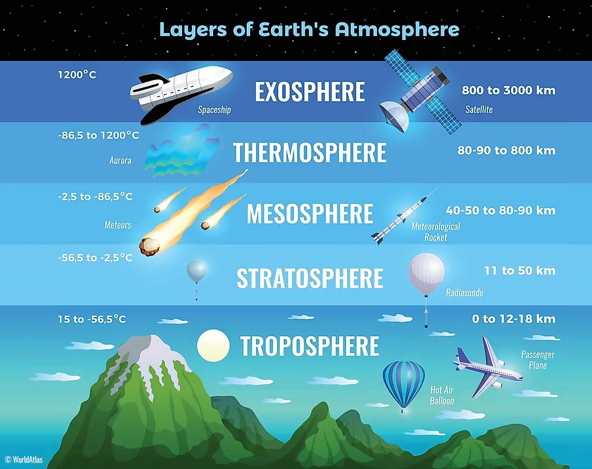
The Earth’s atmosphere has six layers around the planet. Most of the dynamics for our daily weather occur in the lowest two layers, known as the troposphere and the stratosphere.
Another essential feature in the stratosphere, which makes our weather even more variable, often triggers significant large-scale and long-lasting winter weather events. This is the Polar Vortex—an enormous, tri-dimensional ring of powerful winds moving through the sky above us. The Polar Vortex is spinning around the North Pole, grazing through the air at about 20-50 km above the Earth’s surface with violent wind speed.
The troposphere and stratosphere are crucial for our climate. The Polar Vortex covers most of the bottom half of the atmosphere. Since the vortex extends from the middle of Earth’s troposphere into the stratosphere layer, it significantly affects winter weather across high and mid-latitudes yearly.
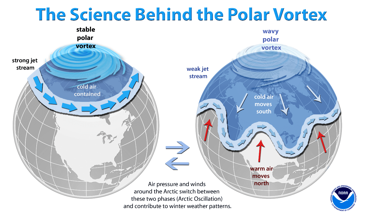
The Polar Vortex is most substantial during winter in the Northern and Southern Hemispheres. Although it spins well above our heads, it remains closely connected with the lowest parts of our atmosphere. Thus, it influences our daily weather in many ways, as it generally functions as one sizeable hemispheric circulation.
The Polar Vortex has triggered the most intense weather systems, from frigid cold outbreaks and winter storms in Canada and the United States to Asia and Europe. Although it affects the whole Northern Hemisphere, its main impact occurs where the southern lobe of the vortex is located.

The active and strong Polar Vortex during the first half of the Winter season 2024/25 was the main trigger behind the historic cold outbreaks in Siberia, where temperatures plunged below -65 °F at the beginning of January.
Recently, the most intense part of the vortex, the southern lobe of the Polar Vortex, has shifted to the North American side of the northern hemisphere.
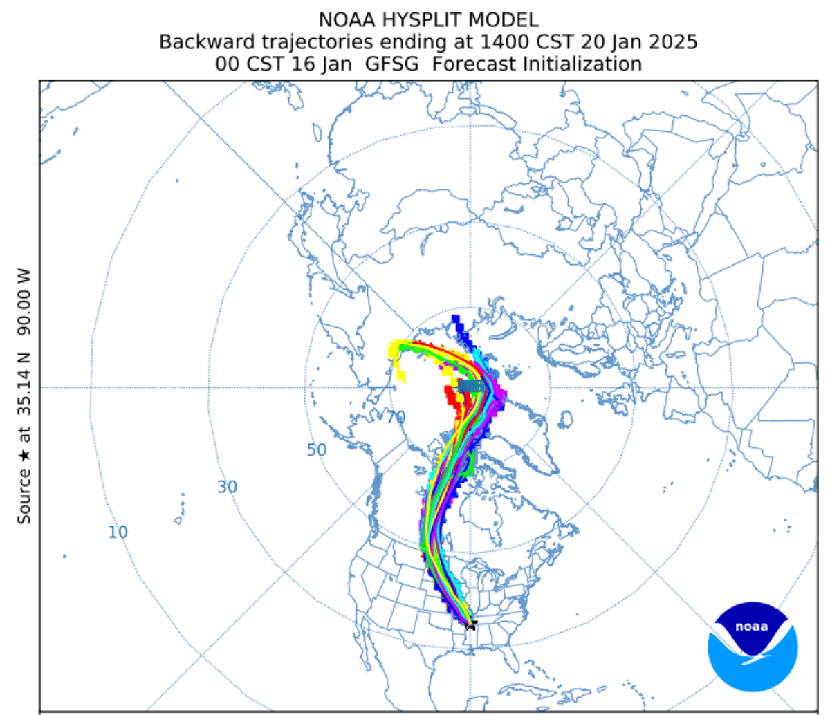
This following NOAA HYSPLIT trajectory reveals that the air mass engulfing the United States originates in northern Siberia. The same air mass that plunged them into brutal cold earlier this month.
This is where all the fun begins, as Canada and the United States are now being blasted by frigid cold weather that will extend throughout the end of January.
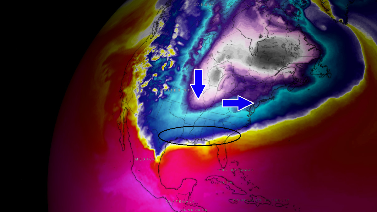
A significant and deep upper engulfs southern Canada and the United States, triggering a powerful Arctic Blast
Following the large-scale blocking ridge (High) that developed over the North Pacific and Alaska, a deep cold wave under the lobe of the Polar Vortex aloft caused a significant Arctic Blast over Canada, rapidly spreading across the United States this weekend.
The upper wave will deepen through Sunday and Monday, allowing the frigid cold Arctic air mass to continue south towards the Gulf Coast.

In response to significantly colder temperatures descending from the upper levels towards the surface, the cold pool will establish an extensive high-pressure system at the surface across western Canada and into the United States.
The frigid cold weather will spread across much of the U.S. through Monday, being the most intense and significant across the northern states, as seen in the following 850 mbar temperature anomaly. More than 28 °C below normal will move across the Dakotas.

Near-surface temperatures will be extremely low, around 40 to 50 degrees F below normal in some areas. In mid-January, daily temperatures will be 30 to 50 °F below normal across the north, posing a high risk of hypothermia for those exposed outside for too long.
Conditions will be frigid, with the highest daytime temperatures ranging from -5 to -10 °F from eastern Montana and Wyoming across the Dakotas to Minnesota and Wisconsin on Monday. Temperatures further south will also be very low, staying below freezing as far south as West Texas, southern Arkansas, and Atlanta, GA.

The cold pool will also remain on Tuesday; the most frigid air masses remain across the Upper Midwest and the Great Lakes.
The arrival of cold air in the western Gulf and additional upper waves will trigger a new winter storm, causing more snow in the southern states.
Potentially historic snowstorm for the Gulf Coast as Winter Storm Enzo forms on Tuesday
The following chart shows the snow forecast from Monday through Friday next week. A swath of rare deep snow will blanket the Gulf Coast region.
Around 4 to 8 inches of snow are forecast from far eastern Texas to southern Louisiana, Mississippi, southern Alabama, and Georgia to the coastal areas of North and South Carolina. On Tuesday, a few inches of snow are also expected to blanket the Florida Panhandle.

Houston (TX), Baton Rouge, New Orleans (LA), and Mobile (FL) could see around 4-6″ of snow. If these forecast amounts are verified, snowfall would be historic, breaking the existing daily or station records.
A sharp boundary between strong, warmer southerlies from the Gulf of Mexico against the Arctic Blast will also develop. Thus, a narrow corridor near the warm front could also lead to sleet and freezing rain.
This is the most likely to develop from the Florida Panhandle across extreme southern Alabama and Georgia to the South Carolina coast, where conditions will be the most critical to support ice storm potential. However, only a few hour’s time window below the much colder air mass changes freezing rain to heavy snow.

Further north across the Great Lakes region, the persistent frigid cold and northwesterly winds will support a typical lake-effect snowfall for multiple days around the lakes.
The highest amounts are forecast to reach 15-30 inches across the eastern shores of Lake Huron, Erie, and Ontario. Although the ice coverage of the lakes gradually expands with the frigid cold, enough exposed water to extreme cold will support intense lake-effect snowfall from Monday through the following weekend.

Stay alert for extremely cold weather conditions, dangerously low windchills, and rare snowstorms for the Gulf Coast as winter storm Enzo arrives on Tuesday.
Wxcharts, Windy, and Pivotalweather, provided images used in this article.
See also:
An Unstoppable 2025 Polar Vortex: The United States Cold from the Stratosphere