The Polar Vortex and its dynamics are powering recent and upcoming cold events in the United States. We are starting to see that an unusually strong Polar Vortex in the stratosphere will help to intensify the low-pressure systems over North America, fueling the cold polar air transport into the United States.
The Polar Vortex is what scientists call the whole air circulation over the winter hemisphere. It is made out of two main layers and can shape the weather in your backyard in a very significant way.
We will look at what the Polar Vortex really is, and how did it help to unleash a cold winter period over North America. As you will see, the Polar Vortex plays by different rules in this 2025 season, helping to create one of the coldest winter months in recent years or perhaps even decades.
A FORCE OF NATURE
Polar Vortex is one of the important factors in every winter season. This is a rather broad term, but in most cases, it is used to describe the whole weather circulation in the lower half of the atmosphere. And based on its size and impact, it really is a force of nature, or more specifically, the weather.
We separate the entire Polar Vortex into an upper (stratospheric) and a lower (tropospheric) part. They both play their role differently, so we monitor them separately. But since they are both one single system, it matters how exactly they are connected. That is especially coming to light this season, as we will show you further down.
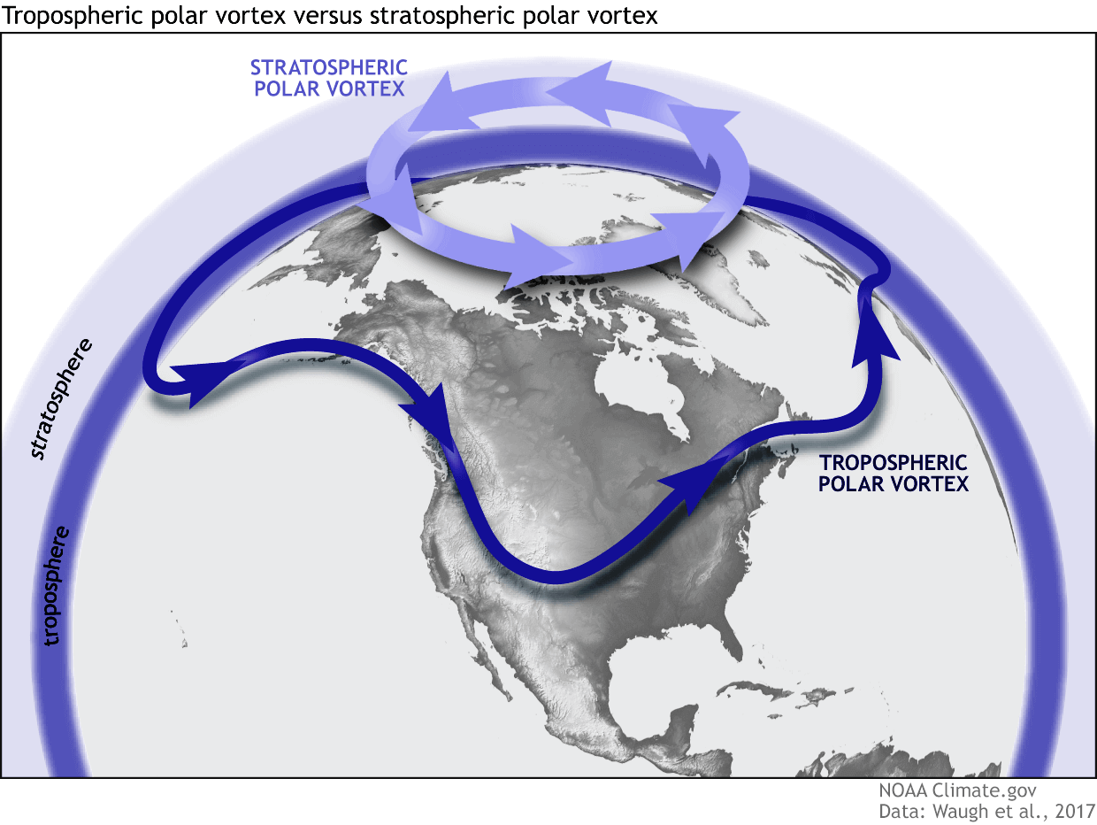
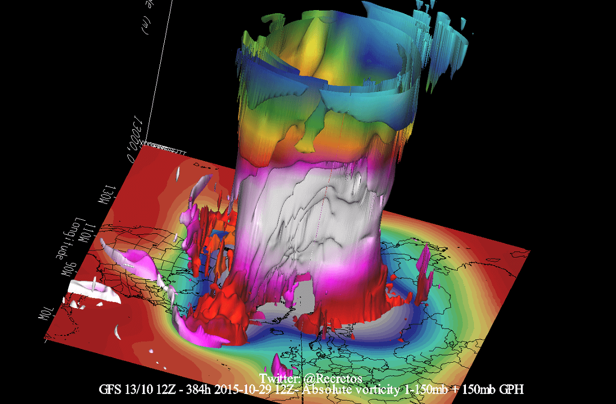
Below is an example 3D image of the Polar Vortex, extending from the lower levels into the Stratosphere. The vertical scale is greatly increased for better visual presentation. This image shows the average shape and structure of the winter Polar Vortex.
As you can see, the lower Polar Vortex is larger and more disrupted, looking like the “feet” of the whole Polar Vortex. It is disrupted because it has to interact with complex terrain and mountains across the Earth’s surface, and strong pressure systems.
This means that the lower Polar Vortex is much more dynamic and can be broken apart, and its cores are more free to move around. All this while still being connected to the main core above in the stratosphere.
We have seen many times how the movement of the Polar Vortex plays a role in changing the weather patterns over North America. One such example was just at the start of the meteorological Winter.
Below is the image of the Polar Vortex in the lower Stratosphere at the 50mb pressure level (20km/12.5miles) in late November. You can see how the stratospheric Polar Vortex was elongated in shape, pressed from both the Pacific and the North Atlantic sides. That elongated the Polar Vortex, pushing its core into an oval shape and extending its core into North America.
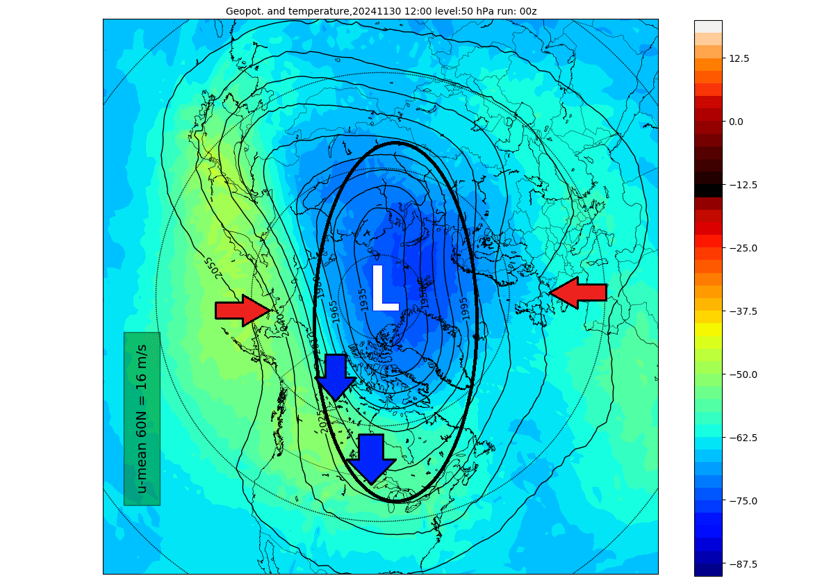
Looking at the atmospheric pressure analysis for that period, you can see how the large low-pressure anomaly over North America was directly connected upwards into the main Polar Vortex above. This has brought the first major cold air event of the season into the United States and Canada.

The elongation of the Polar Vortex was connected to the lower levels and helped to create a broad low-pressure area over the United States and eastern Canada. Because a low-pressure system spins counter-clockwise, this produces an active cold air transport line directly from the polar regions, called the cross-polar flow or the “polar express”.
An example of this dynamic can be seen in the video below, which shows the vortex in 3D, giving you a better idea of what it looks like and how it spins. But note that the vertical size of the vortex was greatly enhanced for visual purposes.
Another very strong example of this cold dynamic is coming in a few days, bringing the coldest air of the season into the United States.
FROM STRONG POLAR VORTEX ABOVE TO COLD BELOW
We monitor any Polar Vortex activity because it often affects weather across the entire Northern Hemisphere. Especially during the winter season, when it is at its strongest.
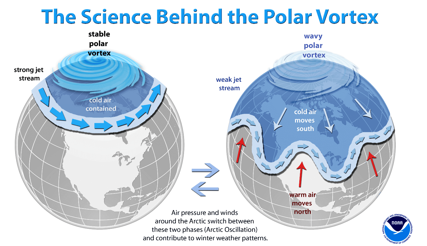
A strong Polar Vortex usually means a strong jet stream pattern. This usually locks the colder air into the Polar regions, creating milder conditions for most of the United States and Europe.
In contrast, a weak Polar Vortex can create a weak jet stream pattern. As the jet stream breaks down, it has a harder time containing the cold air, which can now escape from the polar regions into the mid-latitudes of the Northern Hemisphere. Image by NOAA.
We measure the strength of the Polar Vortex in the Stratosphere by looking at its winds, which you can see in the analysis below. The purple line shows the last two months, and the brown line is the forecast for the next few days. You can see the long-term average with the black line, which outlines the normal power progress of the stratospheric Polar Vortex over the cold weather season.
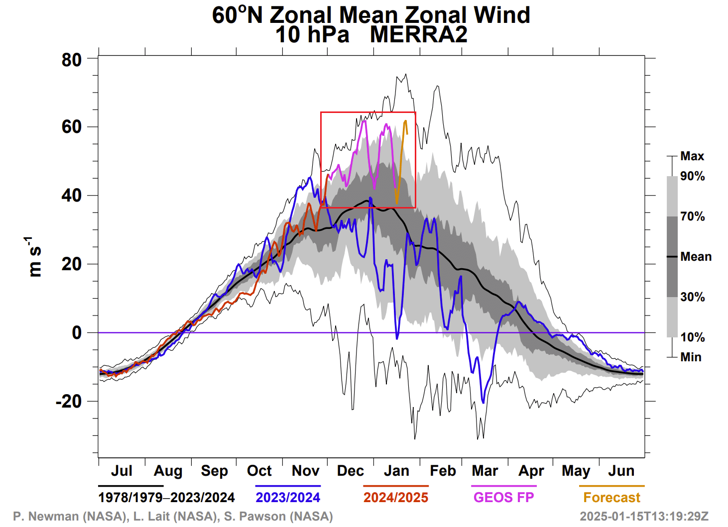
You can see that the Polar Vortex in the mid-stratosphere is much stronger than normal, reaching even as high as near-record strong. It is forecast to reach another power peak in the coming days (brown line). There is no indication of the Polar Vortex starting to slow down, as is normal for January, making it look really unstoppable this season.
But wait a minute, isn’t winter supposed to be warmer and boring if the upper Polar Vortex is strong? Generally speaking, yes. But this winter, we have a unique situation where the strong stratospheric Polar Vortex is actually helping to power the cold outbreaks over the United States.
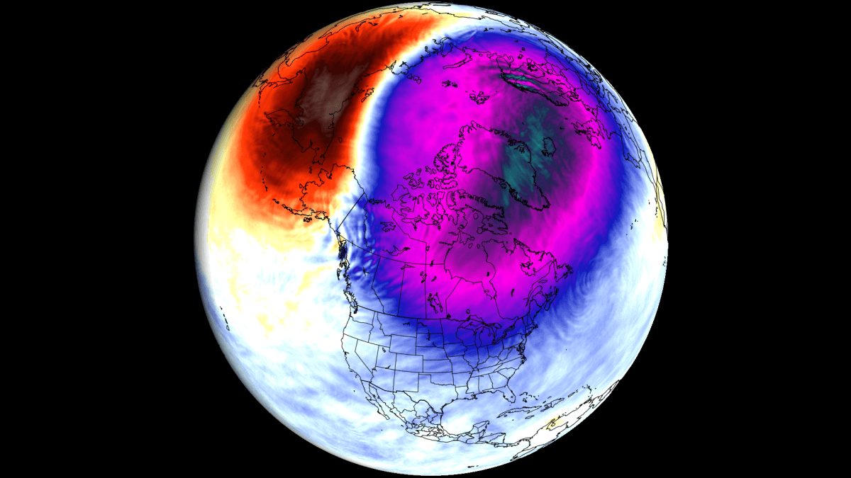
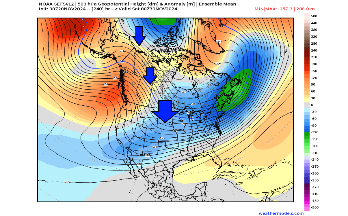
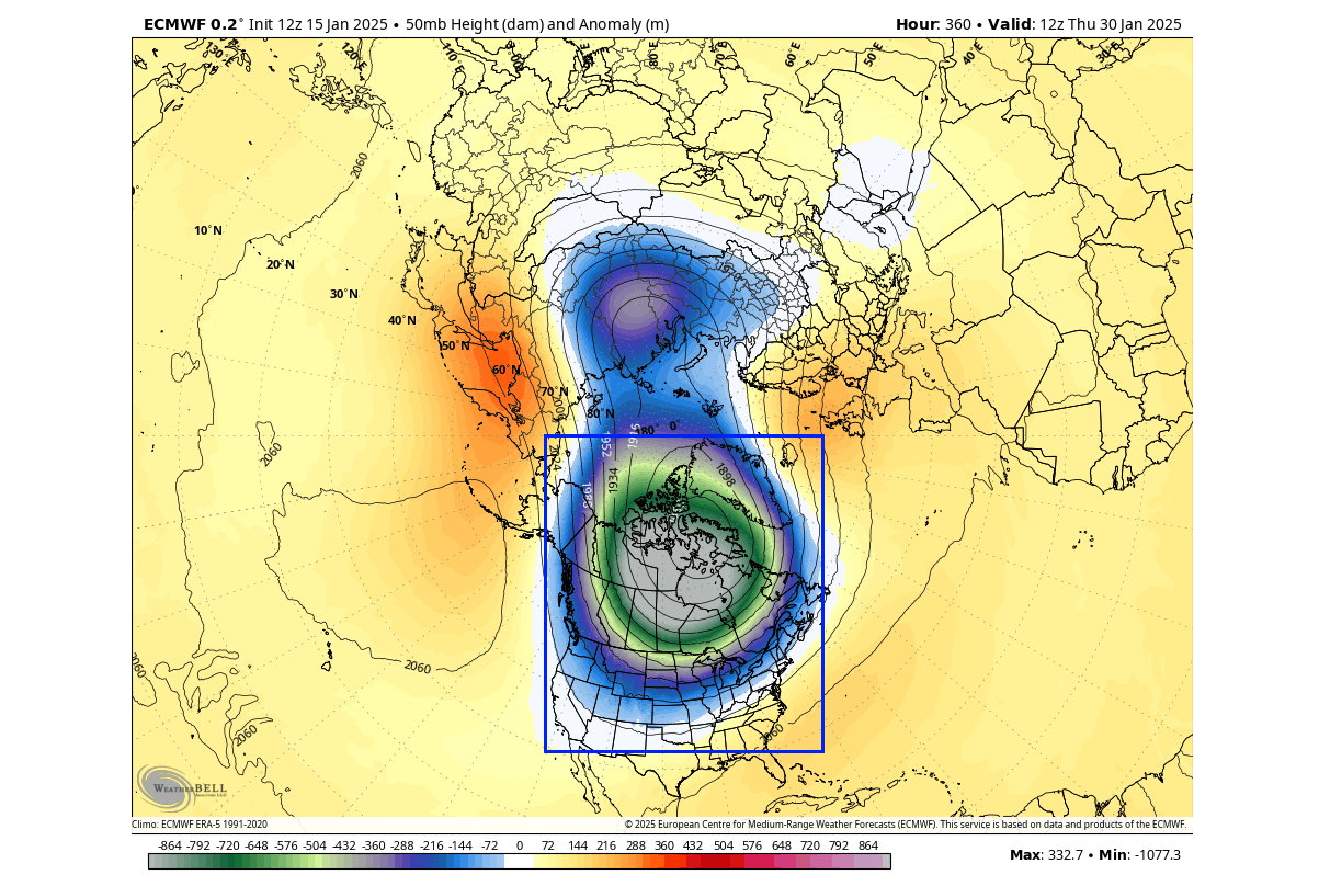
The image below shows geopotential height anomaly at the 10mb level (30km/18.5miles) for early next week. Overall, the stratospheric Polar Vortex looks like a large “cyclone” with a cold core near its low-pressure center. It runs stronger than normal, has much lower pressure in its core, and has a mostly nice (healthy) circular shape.
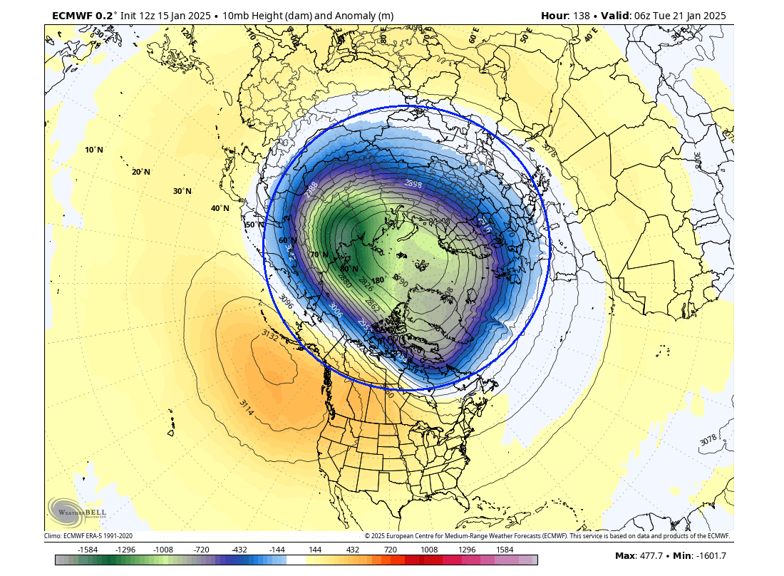
But in the lower Stratosphere at the 50mb pressure level (20km/12.5miles), you can nicely see how the Polar Vortex will be elongated in shape and is under pressure from both the Pacific and the North Atlantic sides. That deforms its inner core and will extend its arm (lobe) deep into North America, all the way to the southern United States.
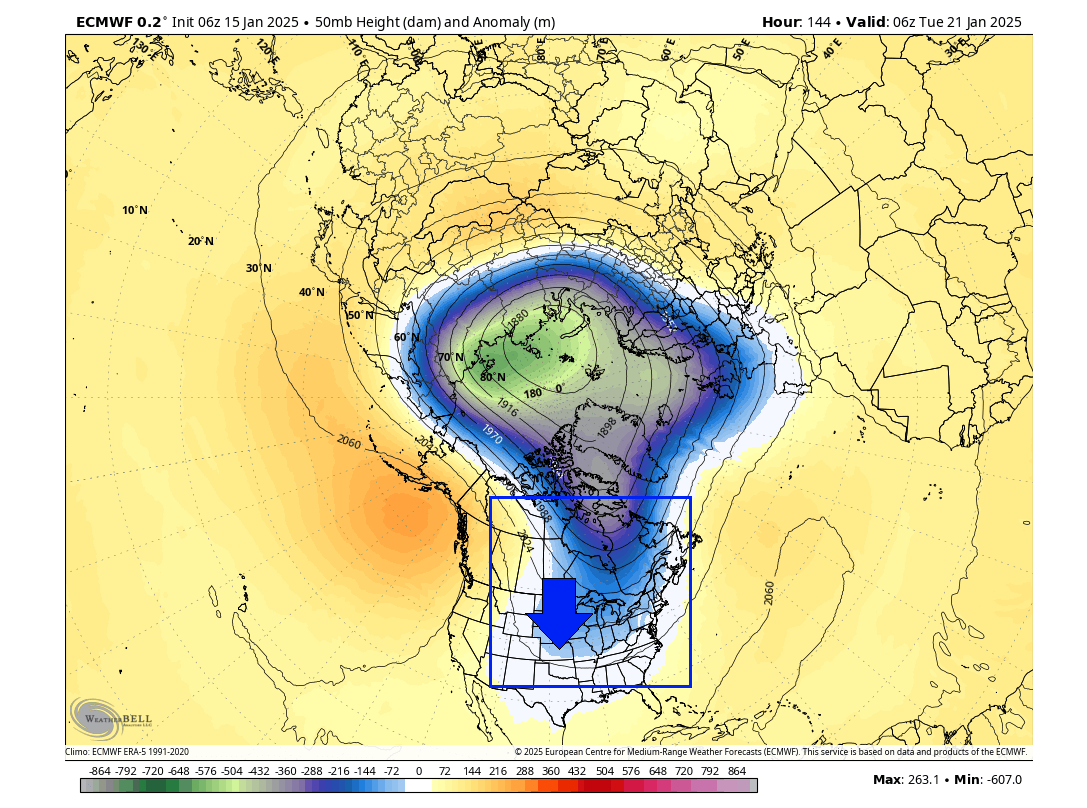
Looking at the whole lower half of the atmosphere in this period, you can see how the large Polar Vortex in the stratosphere will directly connect downwards into North America. This almost looks like it is powering or “feeding” on the energy of the large, strong Polar Vortex above. Overall, in the lower levels, the Polar Vortex is split into two main areas, making it look like it has “legs”.

Speaking of the lower levels, below is the weather pattern forecast for the same period. You can see two main areas of low pressure. The main area is over North America, which shows a direct connection with the Polar Vortex in the stratosphere.
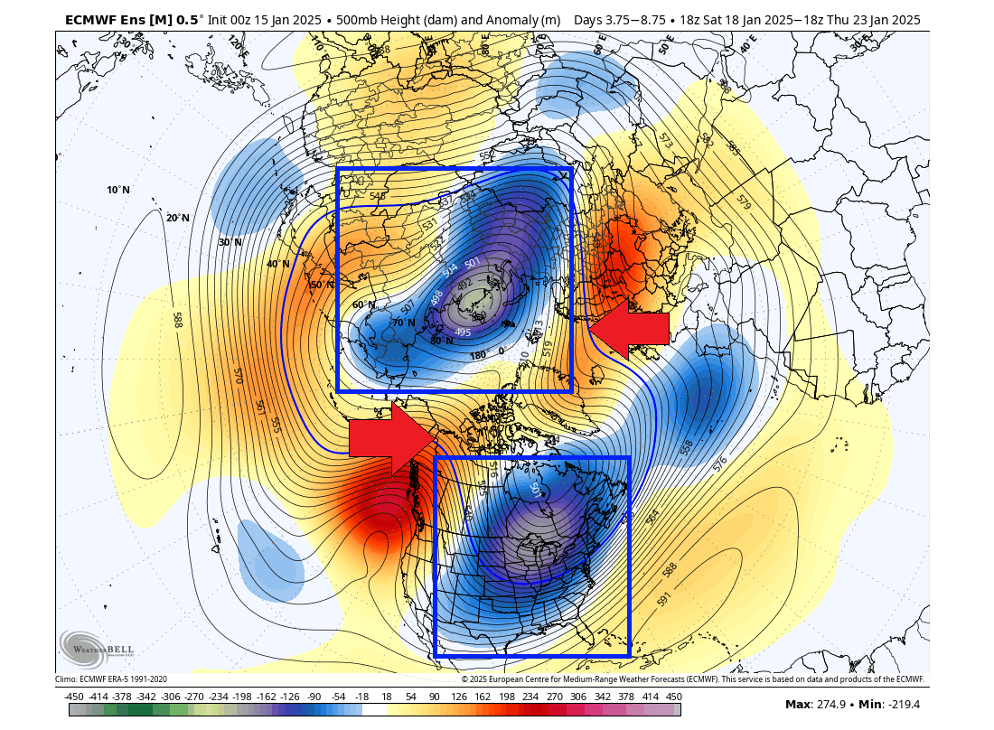
You can also see the two strong high-pressure areas that have split apart the polar circulation in the lower levels and what gives the “legs” to the Polar Vortex. This is why we have an unusual cold in the United States despite a strong Polar Vortex above, which should lock the cold air into the polar regions.
The high-pressure regions in the lower levels broke down the normal circulation. But the connection to the main Polar Vortex in the stratosphere is still active. And since the upper Polar Vortex is unusually strong, it powers down the large low-pressure area over North America.
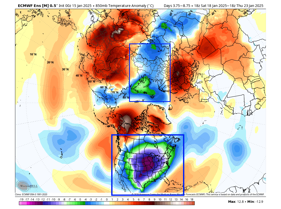
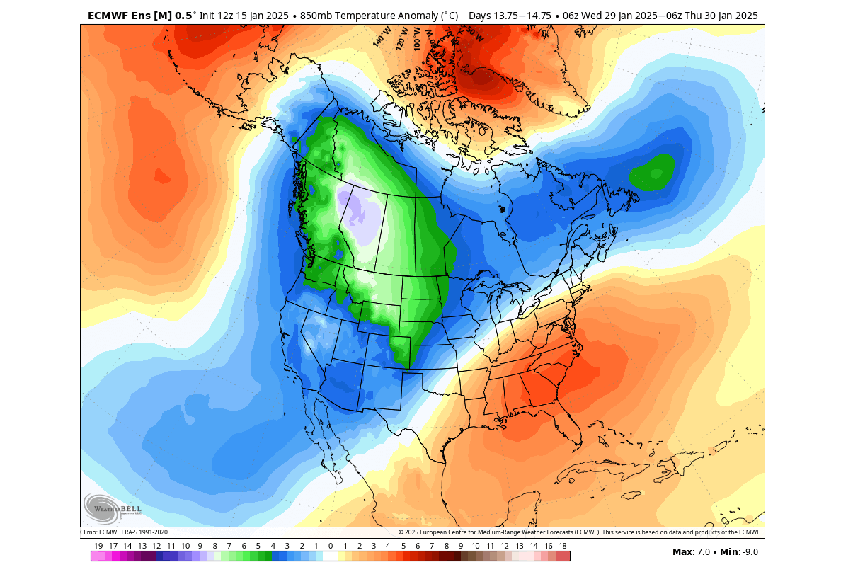
Looking at the temperature anomalies for the same period, you can see the large displacement of very cold air over the United States and southern Canada. This is caused by the very strong Polar Vortex arm/lobe powering the low-pressure area over North America, pulling deep Arctic air down into the United States.
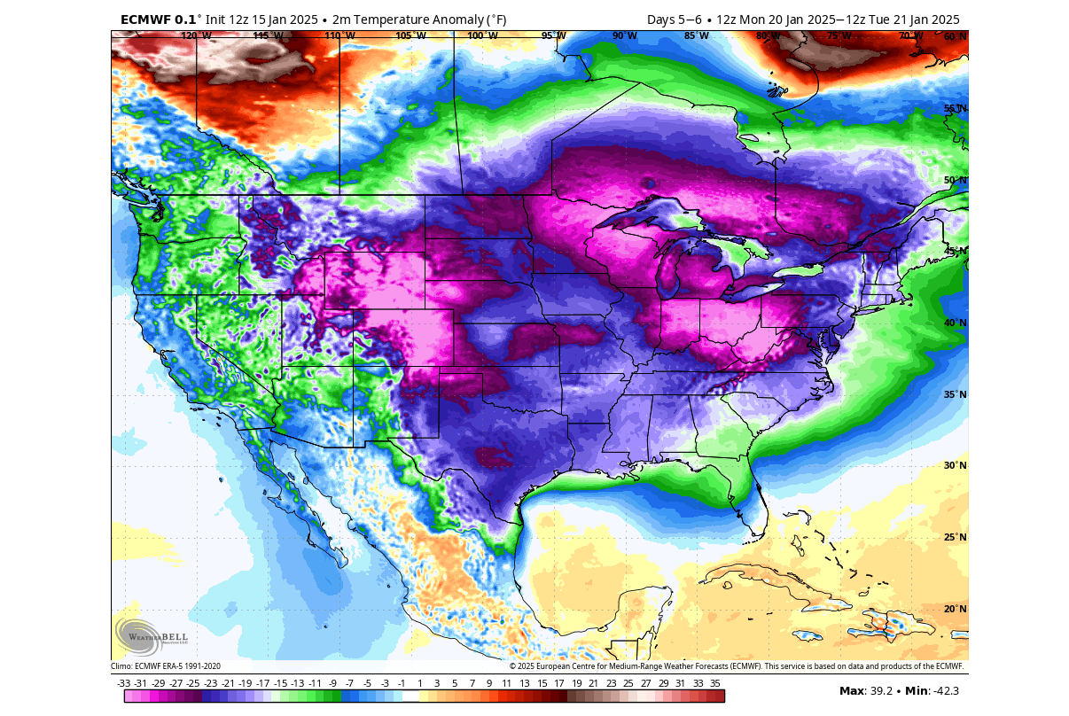
Below is the surface temperature anomaly forecast for early next week, which shows a very cold airmass spreading over the entire United States, coast to coast, and even down into the gulf. This is expected to be the coldest event in the United States and southern Canada so far this winter.
When we see such events developing in the forecast, or even if you see this all over the news, it can be hard to imagine what powers drive these large-scale cold events. In reality, a large global weather system is behind these events, and as you have seen, it even reaches far upward into the stratosphere.
Looking at the total snowfall forecast for the next two weeks, you can see that much of North America is going to experience snowfall at some point. What is interesting to see is that the current snow forecast even shows snowfall reaching almost as far as the south coast. That is a big testament to just how cold this upcoming airmass will be.
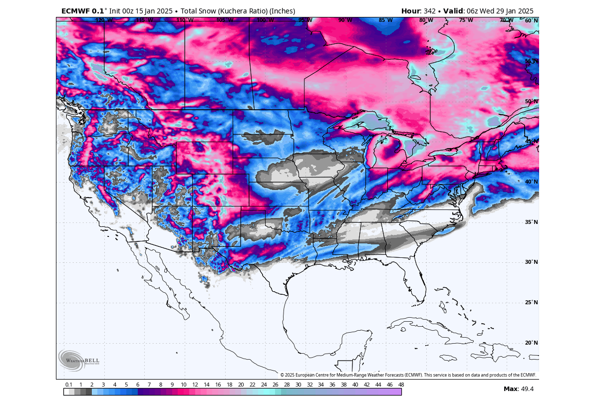
As said before, there are no guarantees for this exact scenario to develop, as this is just one forecast run, which does serve as an example of how the upcoming trend could develop.
But what can we expect from the Polar Vortex at the end of January and as we enter the final month of meteorological winter?
UNSTOPPABLE POLAR VORTEX
Below is the ensemble forecast of the stratospheric Polar Vortex winds. You can see that the forecast keeps the upper Polar Vortex stronger than normal well into February. The new peak is coming just next week, along with the strong cold outbreak across the whole United States. It shows no sign of slowing down, making it unstoppable for now.

We can first look at the lower stratosphere forecast at the end of January. You can see the main core of the polar vortex is extended and the pressure anomaly in the lower stratosphere is reaching into North America. This shows continued support for a low-pressure anomaly below in the lower levels.
We can again look at the vertical structure map to see its connection to the lower levels. For the end of the month, it shows the strong upper Polar Vortex, connecting down to a low-pressure anomaly over North America.

Looking at the lower-level pressure pattern forecast, you can see this broad low-pressure area that sits over Canada and the United States. This is just the lower arm/lobe of the stratospheric Polar Vortex. It can provide continued support for a northerly flow and transport of colder air into the northern, central, and eastern United States

The following surface temperature forecast below is just a single forecast run. But we can use it as an example of what a scenario can evolve from such a pattern, powered by the stratospheric Polar Vortex. A broad cold-air anomaly again covers much of the northern and central United States, extending down from southern and western Canada.

If we could go further in the forecast, it would probably show the cold airmass progressing further to the southern and eastern United States.
For a bit better accuracy, we usually use the ensemble forecast at this range. That is because the ensembles have 50 different calculations in the mix, so it shows a simple average of all scenarios.
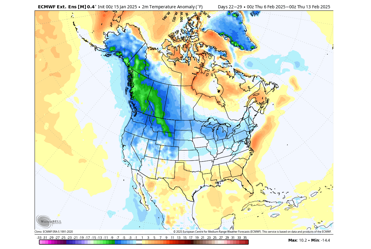
Below is the airmass temperature anomaly in the same period for the end of the month. It shows continued cold air piling over western Canada, covering most of the United States except for further east and southeast. This shows that cold air will be available in Canada and the northwestern U.S. to be released down.
Such pooling of cold air means that when we have a shift in the pressure systems or just normal progression, that cold can be released at any time deeper into the United States. So this basically means that while the daily temperatures over the eastern United States will try to normalize, a new cold burst can follow soon after.
A higher chance of continued cold weather remains over the central and south-central United States, and especially over the northern United States, the Pacific Northwest, and the whole of western Canada.
Looking into the extended range, we see the new trend continuing. The pressure pattern for the first week of February shows the continued presence of a low-pressure system over western Canada and the northwestern United States, connected with the Polar Vortex in the stratosphere.

The temperature forecast for this period shows a weak signal due to the extended forecast length. But it does show continued cold air pooling over western Canada and the northwestern United States. This is almost like floodgates for the cold air. And just a simple transition of a pressure system can release that cold back into the northern, central, and eastern United States, as is indicated by the forecast.
What this can tell us, is that February will bring a bit different weather pattern. One that is still connected to the stratospheric Polar Vortex but with the lower core down moving a bit further west. That traps the cold air over western Canada and the northwestern United States, keeping it ready for release down across the United States with pressure changes.
We will keep you updated on the developing weather trends in the coming weeks, so make sure to bookmark our page. Also, if you have seen this article in the Google App (Discover) feed, click the like and follow button there to see more of our forecasts and our latest articles on weather and nature in general.
The main forecast images in this article are from weatherbell maps and weathermodels, using a commercial license.
Don’t miss out on another large-scale background driver that helped to create this very cold pattern over North America: La Niña boosts the Polar cold over North America, but an El Niño now appears on the Horizon in long-range predictions