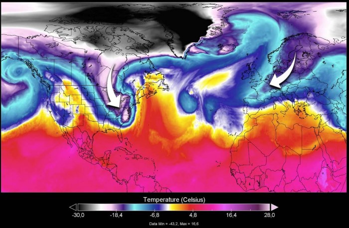
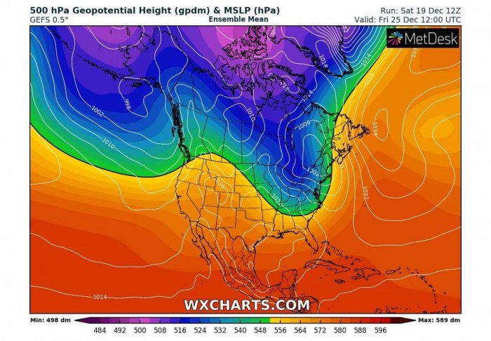
Christmas 2020 is less than a week away, so we take a look at the weather forecast for the upcoming holidays. An Arctic outbreak and a winter storm are forecast for the East Coast of the United States while a pattern change brings cold winter weather and snow in parts of Europe on Christmas day as well. We also include our traditional White Christmas outlook potential for both sides of the North Atlantic.
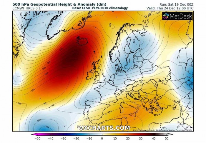
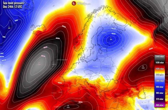
According to the recent weather model guidance, the overall weather pattern is scheduled to gradually change in the upcoming Christmas week across Europe and the North Atlantic. Blocking high forms over the Atlantic and turns the flow into the meridional direction, so from the Arctic region towards the European continent.
While on the other side of the Pond, a major winter storm and snow are in store for Christmas week in a good part of the United States. There will be also very heavy rain and some severe weather potential along the cold front moving across the Southeast parts of the country and the East Coast.
First, the following in-depth discussion below is the Christmas 2020 weather forecast summary for Europe and the United States.
We are also looking over the odds for a White Christmas across both continents. There are fairly good chances that some parts of Europe and the United States will enjoy a reasonable amount of snow coverage around Christmas and the holidays.
CHRISTMAS WEATHER PATTERN
As it quite often happens, the weather patterns over the North American and European continents are the opposite. For example, North America could have a cold outbreak, while Europe could have a warm period at the same. And vice versa.
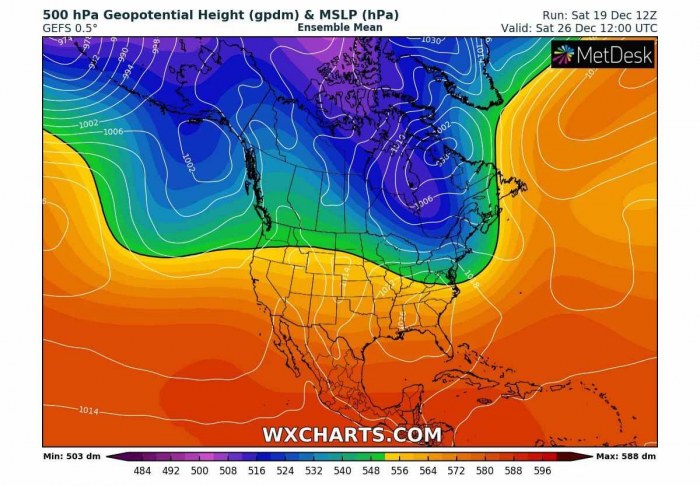
But this year, a powerful Omega blocking ridge pattern develops over the North Atlantic and both continents experience cold outbreaks. Therefore, winter weather is forecast for both the United States and Europe.
Attached below is an example video animation of the quite impressive Arctic cold blast spreading a massive pool of cold air mass into the eastern half of the United States.
The video includes a temperature at around 700 mbar geopotential height – that is a temperature across the mid-level parts of the atmosphere that can best describe the core intensity of the Arctic outbreak.
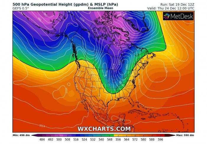
Now, take a look at the first chart again, the one we posted a few paragraphs earlier. See the interesting pattern that is developing across our side of the Northern Hemisphere for this Christmas week.
As the pattern over the North Atlantic flips, it also spreads the cold weather across a large part of Europe.
Let’s get into details about how the pattern evolution will unfold on both sides of the Atlantic.
UNITED STATES – ARCTIC BLAST INTO TO THE EAST COAST
The general weather pattern dynamic across the North American continent this Christmas week is a typical positive phase of the Pacific/North American teleconnection pattern (PNA)*. Also correlated well with a strong La Nina circulation this winter.
This (positive phase) means that an upper ridge is dominating the western part of the North American continent, allowing intrusions of deep Arctic trough on its eastern side. Precisely into eastern Canada and the United States.
In the final days before Christmas this year, an Arctic outbreak with a dangerous winter storm is forecast to impact the East Coast, the Great Lakes, and the Northeast of the United States. It will bring new snow and severe winds, also some severe weather with very heavy rain into the Southeast and the mid-Atlantic.
Pacific/North American teleconnection pattern (PNA)* – is one of the most recognized climate patterns in the Northern Hemisphere mid-latitudes. It consists of anomalies in the geopotential height fields (typically at 500 mbar) observed over the western and eastern United States.
The pattern begins significantly changing from Tuesday into Wednesday, in the final days before Christmas day with the trough deepening over southern Canada, drifting towards the Great Lakes.
Wednesday, Dec 23rd
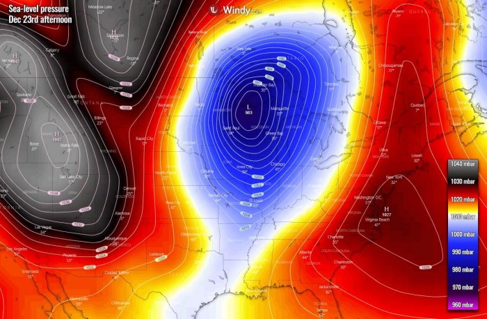
On Wednesday, the trough deepens its associated surface low moving across the Northern Plains, becoming quite deep entering the Great Lakes region. We can see that the pattern is a typical PNA+, blocking high to the west and much lower pressure towards the east of the United States.
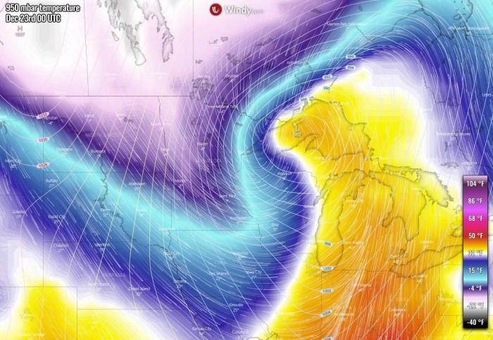
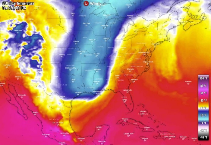
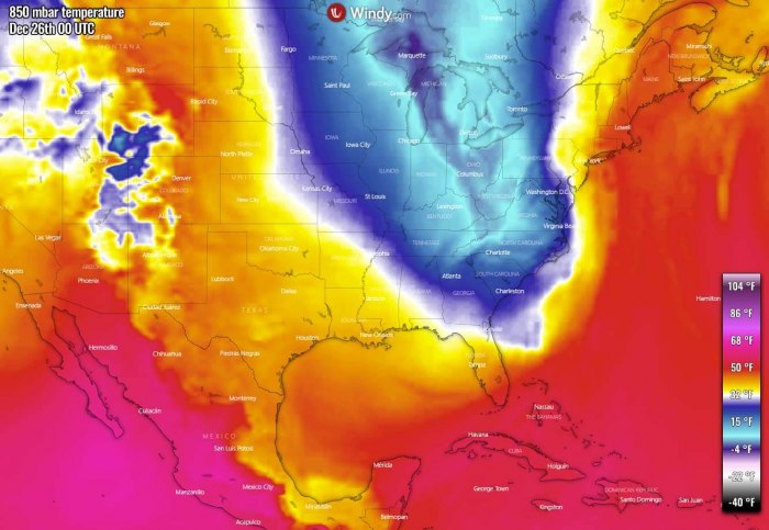
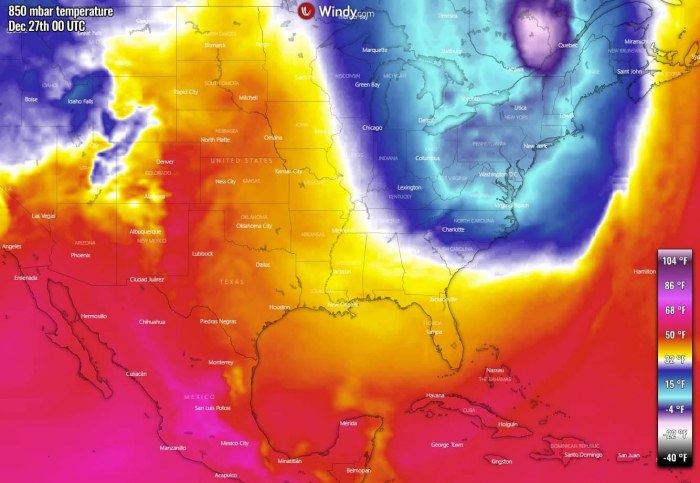
In the wake of the deep surface low, an intense Arctic air mass starts its east-southeast progress from Canada, spreading much colder temperatures into the northern United States and towards the Great Lakes. An impressive warm advection will temporarily push northward ahead of the moving low.
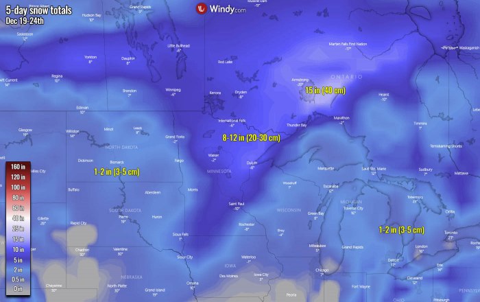
The low could introduce a significant snowstorm for Minnesota and dangerous winter weather is forecast. While the ECMWF model is a bit less impressive, the GFS model is showing a quite robust snowstorm. Around 10 inches (25 cm) is possible over Minnesota, around 15 inches (40 cm) in southern Ontario, Canada.
The strong pressure gradient around the surface low will also result in quite strong winds, so potentially introducing dangerous blizzard and difficult driving conditions could develop. As well as snowdrifts blocking the roads.
Thursday, Dec 24th
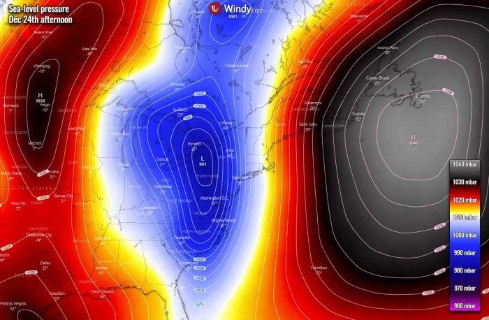
Then on the pre-Christmas day, Thursday, a deep trough continues deepening while moving towards the East Coast. Against the large upper high over the Northwest Atlantic, strong southerly flow establishes moisture advection into the Northeast United States.
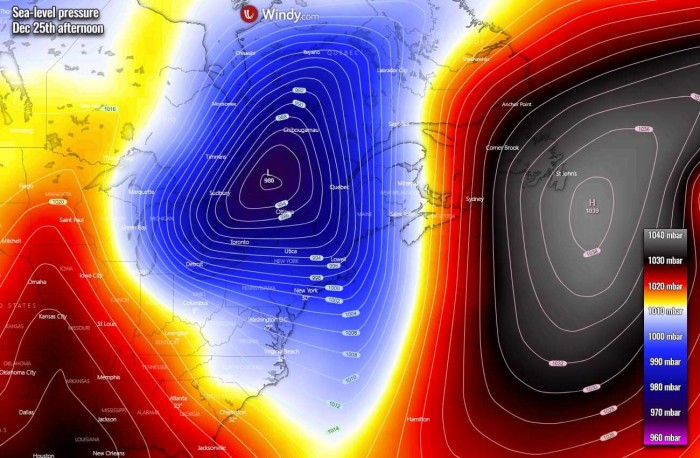
This aggressive pattern is best visible on the sea-level pressure forecast chart where we can see a deep low over the East Coast and a strong pressure gradient is seen along the East Coast and Northeast US.
An Arctic cold develops the surface high further west, across the upper Midwest into the Dakotas and Minnesota.
In response to the deep low over the East Coast, the intense cold blast digs far towards the South, while a much warmer air mass pushes to its east. So the Christmas evening will be rather cold across the central United States, but much warmer across the East. As well as across the West Coast.
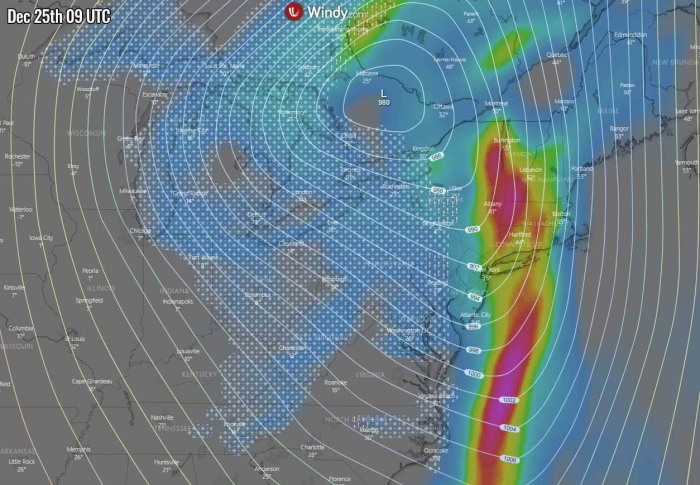
The associated surface Arctic front results in very intense precipitation while racing east-northeast from Christmas evening into Christmas day. A powerful warm advection ahead of the front will introduce very heavy rain across the Southeast United States, gradually moving into the East Coast and the mid-Atlantic.
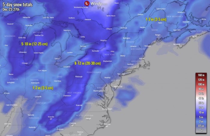
While the rain will quickly change into snow along and to the west of the moving front. Heavy wet snow is expected at the beginning, then becoming dry with blizzard conditions through late Christmas evening. Most likely from the eastern Ohio Valley into Pennsylvania and West Virginia.
There is also some potential for sleet and freezing rain in the vicinity of the surface front. While the very warm air mass remains into the mid-levels aloft, a much colder near-surface temperature will be spreading east quite rapidly and create freezing surface conditions while above freezing remains above this layer.
Therefore a narrow channel along the front could see some freezing rain potential but should be existing for a rather short period, a few hours only.
Christmas day, Dec 25th
For the Christmas day, the main upper trough turns onto the Northeast United States, with a building upper high across the country to its west. The trough remains very deep, supporting additional cold advection into the East Coast.
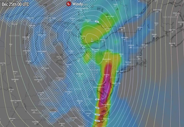
The associated surface low under the deep upper trough strengthens while moving onto the Great Lakes and the Northeast United States. A quite intense snowstorm develops over the region, combined with blizzard conditions given the impressive pressure gradient around the low.
Christmas day will be the peak of this Arctic outbreak for the Great Lakes and the East Coast. The warm advection is pushed east into the Atlantic ocean but it also spreads into New England, Nova Scotia, and Newfoundland ahead of the deep low further west.
The surface cold will be blasting the East Coast and the mid-Atlantic through the early Christmas morning, introducing very heavy rain across New Jersey, Connecticut, Massachusetts, Vermont, and New Hampshire.
Behind the front further west, winter weather with heavy snow is forecast across the Great Lakes into the Ohio Valley and towards Pennsylvania on Christmas morning.
So, proper winter weather for Christmas day!
Saturday, Dec 26th
The pattern continues to eject the deep upper wave from the northeast United States into far eastern Canada, so the weather improves in its wake over the Contiguous United States. A high-pressure system develops over the Southeast.
Although the cold pool is finally vanishing across the East Coast, it remains very cold across the Northeast United States on the day after Christmas. Warmth spreads into the central parts of the country.
The amount of snow will depend on the exact track of the surface low. There are some differences in the model outputs so far, as the event is still a few days out. But fresh snow is definitely expected. Here is the recent ECMWF model guidance.
Strong to severe winds will also develop blizzard conditions, combined with heavy snowfall. Driving conditions for traffic flow will locally become difficult. Especially if sleet and freezing rain would mix along with the front as well.
EUROPE – COLD OUTBREAK TOWARDS THE SOUTH
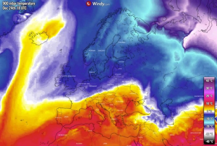
The ongoing stable pattern over the European continent finally breaks and pattern flips for this Christmas week. The North Atlantic goes from a deep trough into a strong blocking high in the final days before Christmas and established an open channel for cold advection from the Arctic region towards the south.
Thursday, Dec 24th
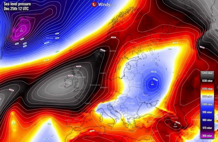
The established pattern then gradually strengthens into the pre-Christmas day, developing a strong surface high-pressure system over the Atlantic and western Europe. Low pressure remains over northern Europe, so the air mass has an undisturbed flow between these two large scale features.
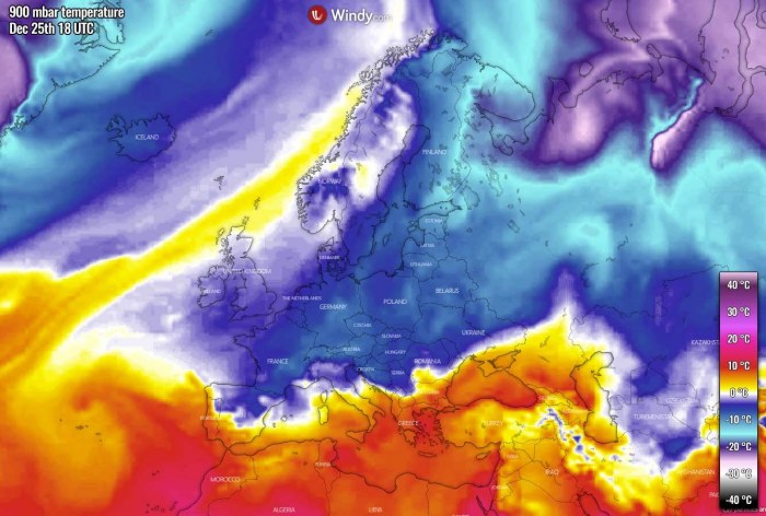
This response in the advection of cold air mass further south into the western, southwestern, and central Europe through the Christmas evening and continues overnight to Friday.
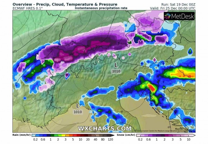
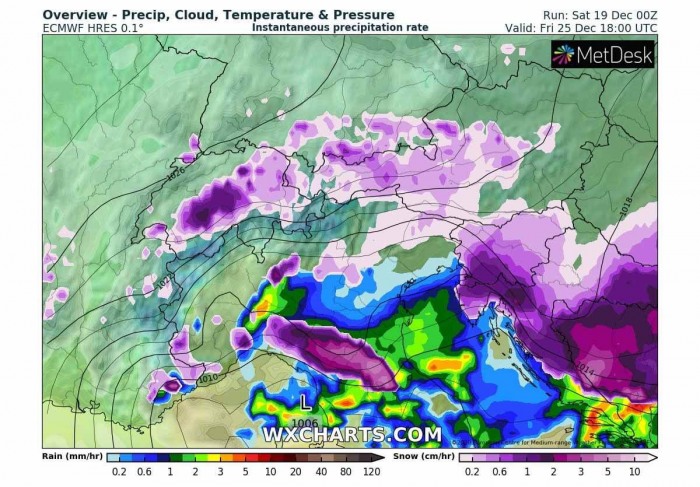
The Arctic front associated with the pattern change will become more active while arriving in central Europe, therefore introducing heavy precipitation. Heavy snow will develop over the Alps through Christmas evening.
Christmas day, Dec 25th
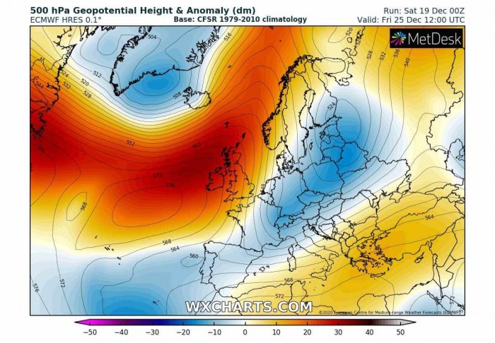
The overall pattern on Christmas day actually doesn’t change much, but it additionally supports the Arctic air mass push further south. Strong blocking high remains over the Atlantic while the trough to its east enters the northern Mediterranean.
This normally means a secondary surface low forms over North Italy, supporting an additional advection of warm air mass towards the moving front from the Alps.
As we can see, the surface high is expanding into western Europe as well, allowing the cold air mass on its eastern flank to move further into the Mediterranean, into the Balkan peninsula, and towards Iberia.
With the Arctic cold front ejecting the Alps, a much colder air mass brings temperatures below freezing, and winter weather is forecast to develop. Heavy rain will change to heavy snow across the northern Balkans, including Slovenia and Croatia.
Strong Bora winds will also develop difficult driving conditions due to blowing snow and blizzard at times in southwestern Slovenia and northwestern Croatia.
How much snow it can accumulate is still uncertain, as both global models GFS and ECMWF are not yet aligned completely. But definitely, there is a strongly increasing potential it will be snowing for Christmas in these areas this year.
Heavy snowfall will be spreading south across the western Balkan through the remainder of the Christmas day and into Friday night.
Saturday, Dec 26th
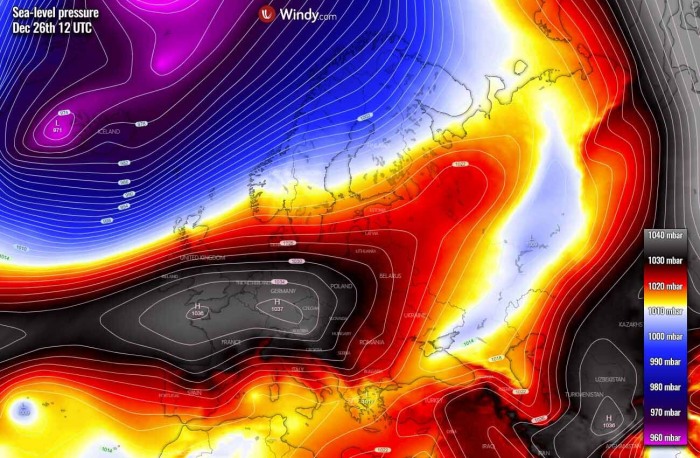
As typical with pattern shaping up around Christmas, the high-pressure system over western Europe expands into central Europe with the Arctic air mass spreading south.
Notice there is another very deep depression over the far North Atlantic – this might be the next focus after Christmas as it may lead to a period of more winter weather according to the global model ensemble forecast. We will be monitoring its evolution.
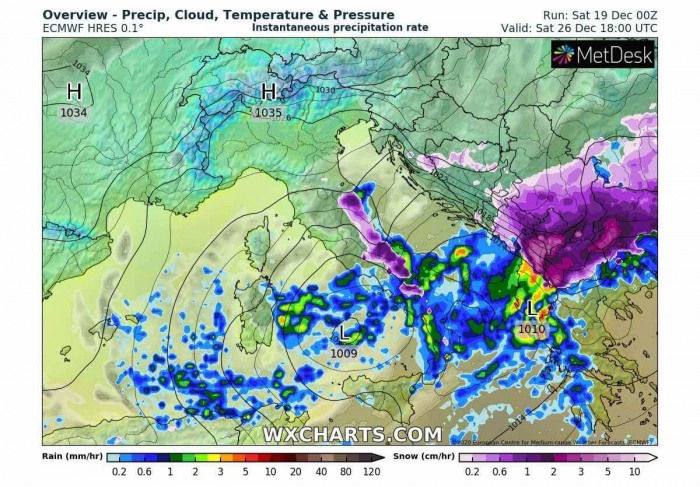
The Arctic front continues further south across Italy, the Adriatic Sea, and the western Balkan peninsula on Saturday, with potentially heavy snowfall ongoing through all day. The front might arrive in the southern Balkan countries (Greece, North Macedonia, and Bulgaria) by Saturday night.
Severe Bora downslope winds could develop across the eastern Adriatic coast, as much colder air mass and higher pressure develop to its north, against the much warmer temperatures further south.
See further details for Europe:
WHITE CHRISTMAS POTENTIAL
So, what about the winter forecast potential for white Christmas across the whole of Europe or the United States?
Snow forecast for the United States
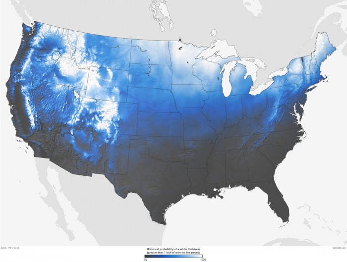
Most of us were probably dreaming of a white Christmas when we were young, right? Indeed, depending on where you live, the odds are high or basically very poor. As per NOAA, a definition for a white Christmas is when there is at least 1 inch (2.5 cm) of measured snow depth on the ground on Christmas morning.
Historically speaking, the highest chances are Minnesota, Maine, Upstate New York, the Appalachians, Idaho, the Rockies, or the Sierra Nevada Mountains. These areas are typical with the best chance of a white Christmas.
The chart above indicates the historic probability of there being at least 1 inch of snow on the ground in the Lower 48 states on Christmas day. While the white colors represent those places where the probabilities are greater than 90 percent.
The darkest grey colors represent places where the probability is less than 10%. So basically the West Coast, the Southwest, South, and the Southeast of the Contiguous United States.
Indeed the map is only showing the historical probability that a snow depth of at least 1 inch will be observed on Christmas day, but the snow depth can vary from year to year.
Now, let’s take a look over the weather forecast for the potential of a white Christmas day for this winter 2020/2021 across the United States. Further below is our own product – a traditional White Christmas Outlook best forecast for the snow coverage.
We normally do an outlook for both the United States and Europe – for the latter, please see a bit further down.
White Christmas Outlook 2020
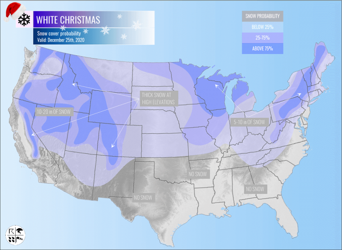
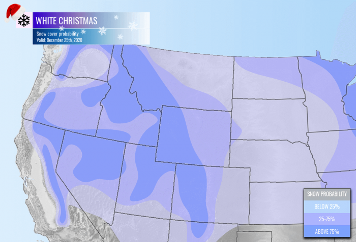
The snow coverage for Christmas day across the United States feels like it will follow the historical probabilities this year. The best chances are seen over the northern half of the country, while there are barely any chances for a white Christmas across the South.
Here is our outlook with the probability of White Christmas 2020:
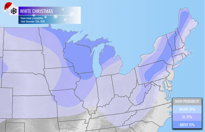
Great Lakes, East Coast and the Northeast United States
However, it looks like there is a last-minute winter storm forecast to hit the East Coast on Thursday into Wednesday. This will help the northeastern part of the United States to get white Christmas this year.
What appears likely is a massive winter storm with fresh snow from the Ohio valley further into the Northeast US.
Parts of the Midwest, the Great Lakes, and the Northeast United States will likely see a white Christmas, thanks to this last-minute snowstorm. Some areas along the Atlantic coast might even lose the snow coverage due to the arrival of a much warmer air mass ahead of the system.
But snowpack seems to remain or even improve further west and north.
Northern and Northwest United States
White Christmas across the northwestern parts of the country will be mainly confined to the deep snowpacks over the mountains, the Rockies are covered in deep snow.
The higher mountains of the Pacific Northwest are getting pounded with remnants of deep North Pacific extratropical lows and winter storms lately, so the very deep snowpack is present.
In addition, there is also some fresh snow coming across this part of the country as the rear side of the new system travels across the region in the days before Christmas as well.
Snow forecast for Europe
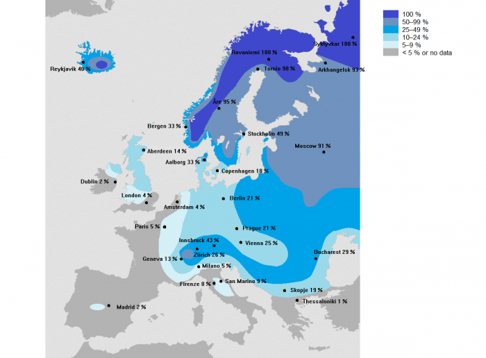
Let’s take a look at what are the historic probabilities for a white Christmas day, defined as having measurable snow on the ground on December 25th, across Europe.
With just a brief looking over the map below, we can quickly see a white Christmas across Europe is actually a quite rare event. If you are a younger reader, you’d say “Christmas has been without snow for years now”. Indeed, it has, unfortunately, become an exception over the last decade.
But historically speaking and based on the statistic probabilities, most of Europe actually has a very low chance to see snow on Christmas day.
As we can see from the map above, only around 5-10 % of Europeans live in an area where Christmas has snow on the ground. Typically that is only over Scandinavia or more precisely, over the Lapland (that area is covering northern Norway, Sweden, and Finland).
If we just think of those white Christmas cards, they are always pictured as snowy.
Unfortunately, in other parts of Europe like England, France, Germany, the Balkan peninsula… the chances for white Christmas are statistically very poor there.
For example over the UK, the last widespread white Christmas was in 2010. It actually was an extremely unusual event, as not only the snow on the ground was reported at 83 percent of the official weather stations network, but the mix of snow or sleet also fell at 19 % of those stations. This was the highest amount of stations ever recorded snow on a single day in the UK.
In contrast, London only had 4 white Christmas days during the entire 20th century. Those were years 1927, 1938, 1970, and 1981. That gives you a clear idea why there is only a 4 % chance for snowfall on Christmas day.
One interesting thing to note from the map, have a look over central Spain (Madrid area) and Dublin (Ireland). Dublin is located quite far north of Madrid (Spain), but the chances for snow covering the ground on a Christmas day are minimal, only 2 % for both areas.
Now, let’s take a look over the weather forecast for the potential of a white Christmas day for this winter 2020/2021 across Europe…
White Christmas Outlook 2020
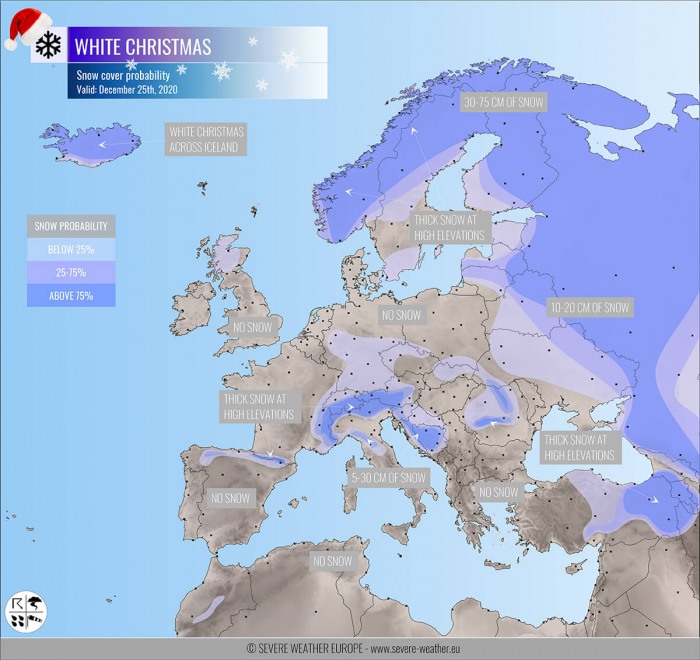
Overall, the snow coverage situation across the European continent is forecast to improve as winter weather is likely to arrive later this week. The general pattern over Europe and the North Atlantic will bring the weather change sometime around Christmas day.
Here is a Severe Weather Europe outlook with the probability of white Christmas 2020:
Actually, the situation is not too impressive, as we can see. The snow is mainly limited to the mountain ranges and far northern Europe. Especially over Scandinavia and Iceland.
Central Europe and the Alps
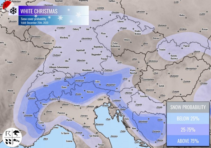
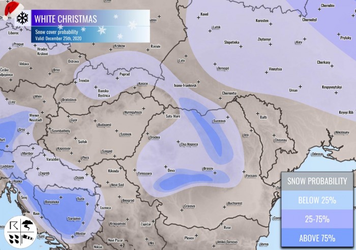
We take a closer look over the snow coverage forecast across central Europe and the Alps. The highest probabilities are indeed over the Alps as deep snow has accumulated over the past weeks. So the snow depth will remain also in the holidays as it usually happens there.
Although the weather pattern forecast across Europe still has some uncertainties next week, there is winter weather possible to develop across parts of central Europe, also into the lowlands.
That is especially in focus across parts of Germany, Austria, and Czechia. Possibly also in Slovenia and Croatia as weather models forecast there are rising chances for an intense winter storm to develop right on Christmas day.
Quite high snowfall accumulations could develop over the northern Apennines and along with the northern Dynaric mountain range across the western Balkan peninsula.
Southwestern Europe
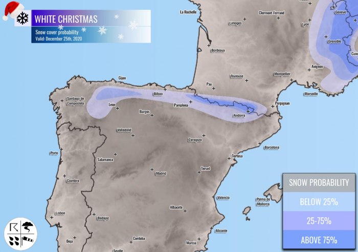
Looking over southwestern Europe and the Iberian peninsula, the snow coverage on Christmas day will remain over the higher terrain of the Pyrenees and the Cantabrian mountain range.
Depending on the progress of the pattern transition into more winter weather around Christmas, it may bring some fresh snow in these areas, as well as across the higher terrain between both mountain chains.
Western Europe
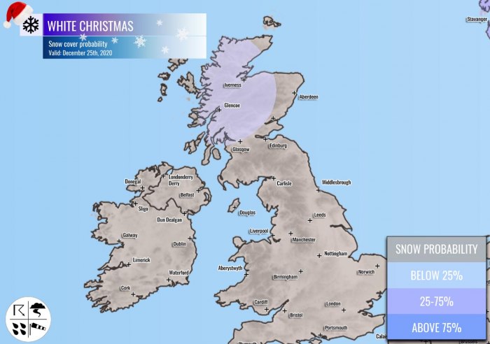
There seem to be rather low chances for a white Christmas across UK and Ireland this year. The weather models do, however, forecast some low potential for the northwestern UK and over Scotland. But it seems the chances are reasonable only over Scotland.
There does not seem that any snow is likely to be on the ground for Christmas over Northern Ireland, Ireland, Wales, and south-central England.
The Balkan peninsula and Turkey
The Balkan peninsula will have two areas where white Christmas is possible this year. One is the western part of the peninsula, where fresh snow seems possible on Christmas day as we’ve discussed earlier.
While the other area is the Carpathian mountains. Those are already covered in snow, so the snow depth will also remain for Christmas. Some snow coverage will remain over the High Tatras, between Slovakia and Poland.
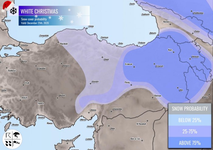
Also over the eastern half of Turkey and Georgia as winter weather is forecast to bring quite some fresh snow in the pre-Christmas days this coming week. High snow depth is expected in the higher elevation of eastern Turkey.
Deep snow depth is also spread across the Greater Caucasus mountain chain, with a significant amount of snow in the highest mountains.
See more details for European weather for Christmas:
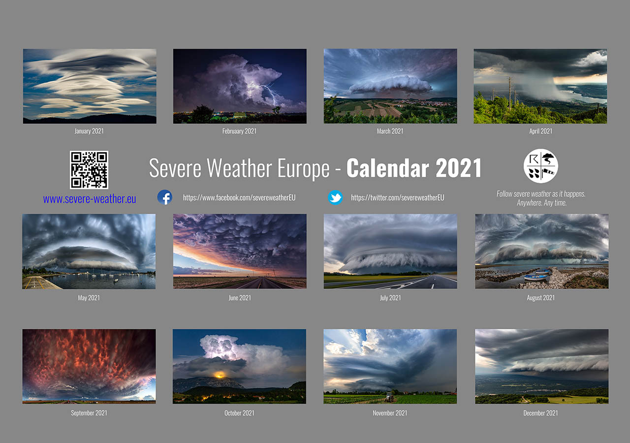
Don’t miss a chance for a nice gift for your friends, family or someone special… Weather calendar could be the perfect gift for them – see below:
