Meteorological Spring 2025 has arrived in Europe, and the weather pattern is becoming much warmer as we head into the new season’s first week. A significant heat dome is forecast to deliver a warm wave across central and eastern Europe, extending well above normal temperatures until the following weekend.
Extensive blocking begins this Monday, gradually strengthening the surface high-pressure system across central parts of the European continent.
This will lead to a significantly warmer period than usual for most of Europe, with the most anomalous temperatures during the second half of the week.

The highest temperatures and anomalies are forecast across central, eastern, and northern Europe, including the Balkan peninsula. Temperatures will be 10-15 °C above normal.
The attached meteogram for Kyiv, Ukraine, shows a long period of well-above-normal temperatures. Under the intense heat dome aloft, at least a week-long warm wave will be established. We will discuss this feature shortly.

Here’s a video animation of the weather’s evolution over the next 10 days, briefly previewing the picture over Europe.
Notice that the weather pattern could also flip after the weekend as the North Atlantic churns a deep low toward the Azores and southwestern Europe.
First, let’s examine what happens under the heat dome and why understanding its behavior and effects is essential. This large-scale feature usually produces strongly anomalous temperatures.
What is a Heat dome?
When significant and historic record-breaking heat waves occurred in Europe, the United States, and Canada in the past, the Heat Dome was the cause. The heat dome is usually the dominant feature of summer weather patterns on both continents.
When highly high temperatures develop, we will use the term heat dome. Here is how it works and why it is essential to understand it on a larger scale.
The upper-level ridge pattern, or very warm air mass in the higher altitudes, also known as the Upper High (or blocking High), usually forms the heat dome. This weather pattern brings very high and sometimes record-challenging temperatures to the region underneath.
This term is used when a broad area of high-pressure parks over a large portion of the continent. If the event is remarkably stable and extreme, it usually lasts several days or weeks.

The heat dome works like a lid on a pot. The extensive dome traps warm air at all levels underneath, with layers sinking toward the ground. Therefore, the air mass becomes anomalously warm at the lowest elevations and extremely hot near the surface.
The Omega blocking pattern
A heat wave associated with a heat dome creates fair, stable weather and an often arid air mass with minimal chances for precipitation or even clouds. This happens due to the sinking air parcels in the center of the heat dome, resulting in rising temperatures.
Note: The weather pattern that develops such extensive events is known as the Omega blocking High. Its shape reminds us of a letter in the Greek alphabet.
The example below shows a pattern that developed over Europe in September 2023. The omega-blocking pattern engulfs a large part of the continent, with a central heat dome and a low-pressure system on each side. In this case, one is over the southern Mediterranean, and the other is over the Azores.

Typically, warmer and drier weather leads to a significantly enhanced wildfire threat due to developing drought or worsening ongoing, preexisting, arid conditions. In recent years, wildfires have occurred in Europe (Portugal, Greece), the Pacific Northwest, and across Canada and North America.
Heat domes are often also to blame for deadly heat waves worldwide, as scorching and excessive heat lasts a long time. In the last few summer seasons, such heat dome events have brought record temperatures in many countries worldwide, sometimes extending into the fall/autumn seasons.
The daily average and maximum temperatures under the heat dome are typically significantly above average. When the dome is mighty, it challenges or breaks existing historical records. This becomes particularly striking when this feature develops during early summer or autumn/fall.
Strong blocking high establishes beneath the heat dome
By mid-week, an extensive blocking High will mature over Europe, dominating most of the continent. Its center will be over eastern and central Europe and the Balkan peninsula.
Further west, a long-wave trough will begin deepening and sliding south towards the Azores.

A heat dome will establish a long-lasting warm wave, engulfing Europe into much higher temperatures than were observed recently.
The 5-day temperature anomaly hints at how intense the warmth will be. It is generally 10-15 °C above the normal temperatures across Eastern Europe for early March.

On Wednesday, temperatures will be 6-10 °C above normal from Germany and Austria to Poland, Belarus, and Ukraine. Warmth will also intensify over the Balkan peninsula countries.
A warm wave will also spread into northern Europe, reaching southern Norway and Sweden on Wednesday.

The peak of the heat dome aloft and related warmth underneath is forecast for Friday, with temperatures becoming a few degrees warmer than during the mid-week.
Significantly high temperature anomalies will occur across Eastern Europe, with temperatures 10-15 °C warmer than usual in Poland, Belarus, Ukraine, Moldova, and Romania.

This will push daytime temperatures into the 16-19 °C range, which is pretty high for early March.
Some areas in Romania, Moldova, and southern Ukraine could reach the 20 °C threshold.

Similar conditions are also forecast across the Balkan peninsula countries, with temperatures into the upper 10s and locally reaching into the low 20s. Temperatures will be highest where dry air mass will help the afternoon warming. The usual warm spots in the Balkans are far eastern Croatia and northern Serbia, southern Romania, and north Bulgaria.
Italy and the Mediterranean will remain on the edge of the blocking high to the east, so temperatures will not be as significantly anomalous as areas over the Balkans.

Conditions will gradually return to typical values over the weekend as more moist air masses push from the west. This will limit the warming usually occurring in dry air masses under the heat dome.
The pattern is likely to flip after the weekend, with a deep trough emerging into southwestern Europe
The weather models agree that the change will arrive over the weekend. A large, deep upper wave will dig far south across the North Atlantic, and the blocking high on the east will collapse and weaken.
By Saturday, it will reach the Azores and turn east into Iberia, resulting in high moisture advection and winds onto the peninsula.

The wave’s core aloft will be cold and significant, allowing a deep surface low to form. Models hint that the central pressure could reach into the upper 970s.
The low will be prominent and establish an extensive pool of moist air mass over southwestern and western Europe, gradually reaching central Europe.
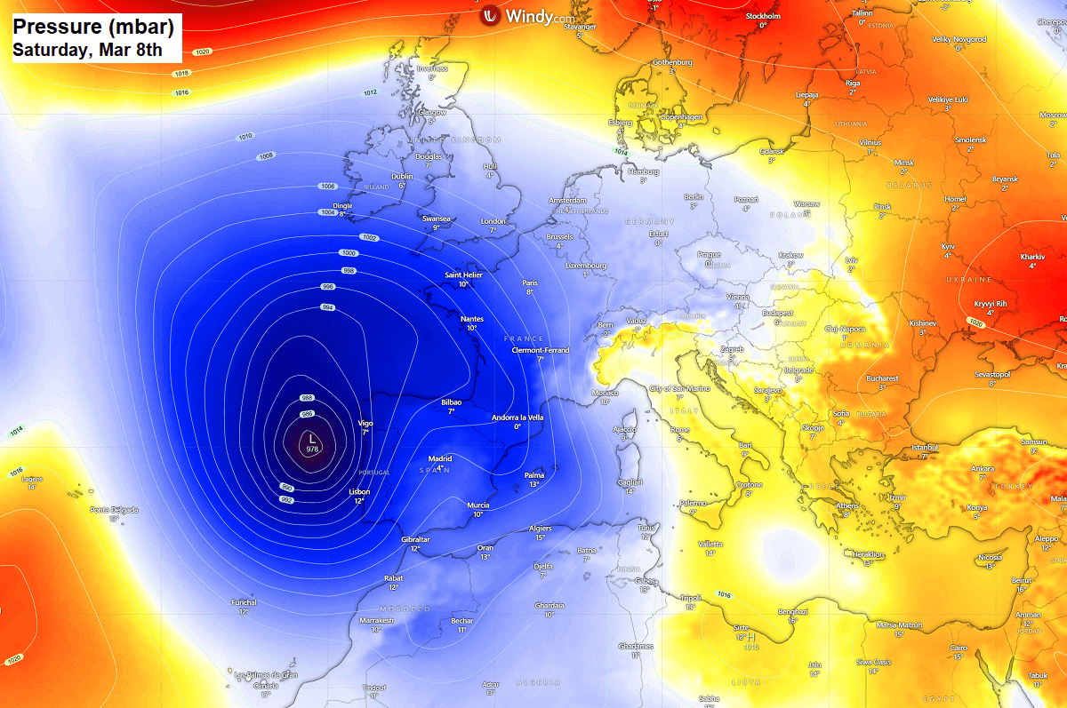
While no strongly defined fronts cross Iberia, the persistent surface low parked over the Bay of Biscay and along western Iberia will maintain a warm air mass and moisture advection across southwestern Europe.
A lot of rain is forecast across Portugal, Spain, southern France, and Gibraltar. Locally, more than 200 mm of rain will accumulate from Saturday through Tuesday next week. The highest amounts are hinted over Eastern Spain; close to 300 mm will be possible there.
This could cause local river flooding.

A deep and persistent low-pressure system will also contribute to windy conditions over the region and develop high sea waves towards Portugal.
Significant wave heights up to 10 meters are forecast between the Azores and Portugal on Saturday, when the most substantial pressure gradient will be in place.

We are closely monitoring the evolution of the ongoing pattern and will update you accordingly. Stay tuned.
Wxcharts, Windy, Ventusky, and Pivotalweather provided images used in this article.
See also:
Spring 2025 in Europe: Unexpected impact of La Niña, seen in the latest Long-Range Forecasts