A strong Stratospheric Warming event is now starting and is forecast to create a rapid and full breakdown of the stratospheric Polar Vortex. The latest forecasts also show the first expected weather response: a high-pressure area developing over Greenland and eastern Canada, bringing late-season cold to the United States.
This is now the second and final disruption of the Polar Vortex in 2025. It is also by far the largest one, sending the Polar Vortex into pieces, not returning again until Fall 2025.
This upcoming event is among the strongest Stratospheric Warming events for this time of year in the past decades. We will look at how this event will unfold and the latest predictions for its impact on the upcoming weather patterns.
WEATHER UNDER THE POLAR VORTEX
The best way to understand the Polar Vortex is to see its structure. But in simple terms, it is a name that describes the broad winter and cold weather season circulation over the northern (and southern) hemispheres.
Below is a 3D image example of the Polar Vortex. The vertical scale is greatly enhanced for better visual presentation. You can see the actual structure of the Polar Vortex, connecting from the stratosphere down to the lower levels and the pressure systems.
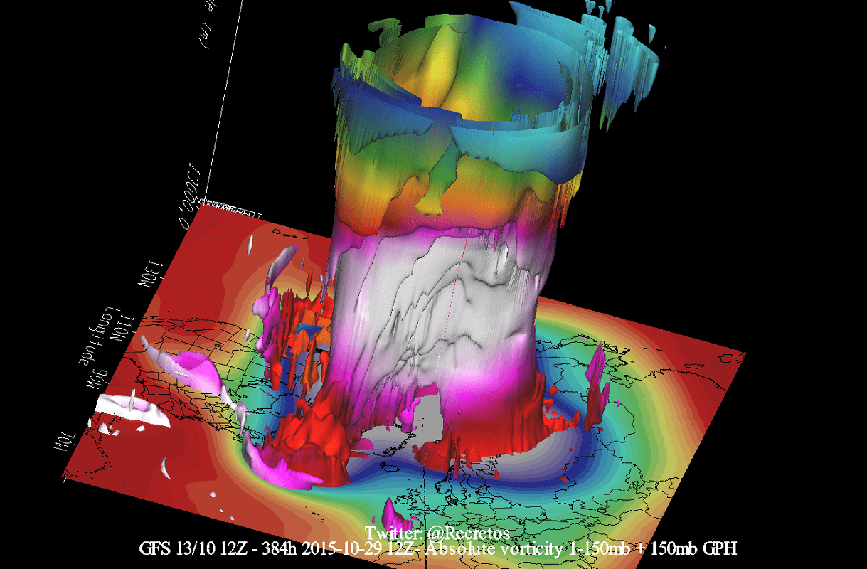
The Polar Vortex extends high across different layers of the atmosphere. The lowest level is called the troposphere, where all weather events occur. But above that, we have the stratosphere, a deeper and drier layer.
For this reason, we separate the Polar Vortex into an upper (stratospheric) and a lower (tropospheric) part. They both play their roles differently, so we have to monitor them separately. However, both parts together form the circulation across the Northern Hemisphere during the colder part of the year (October-March).
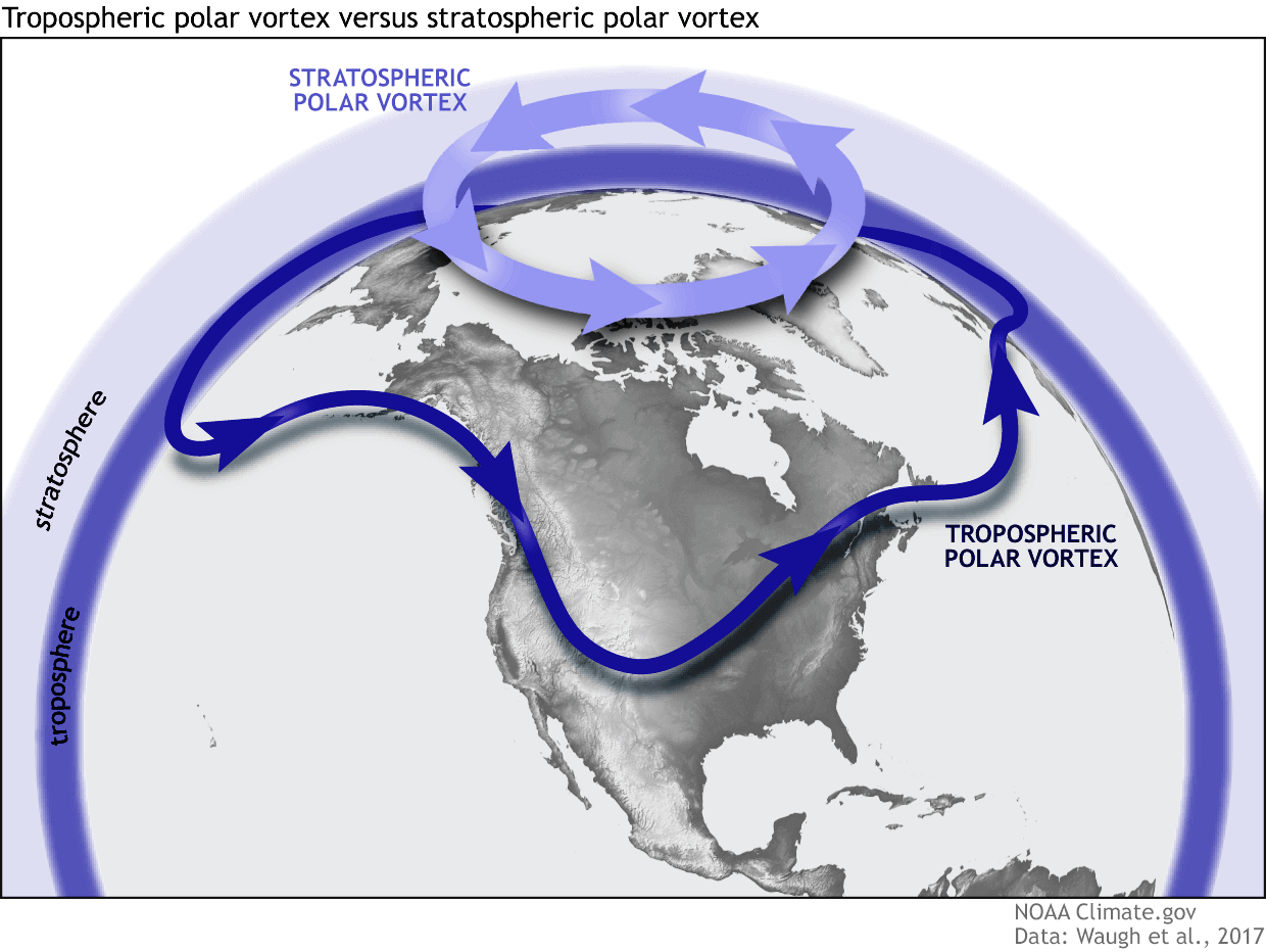
To simplify, all you need to know is that the upper and lower parts of the Polar Vortex are connected. Changes in the upper part can significantly impact the weather anomalies in the lower parts of the atmosphere and the weather at the surface.
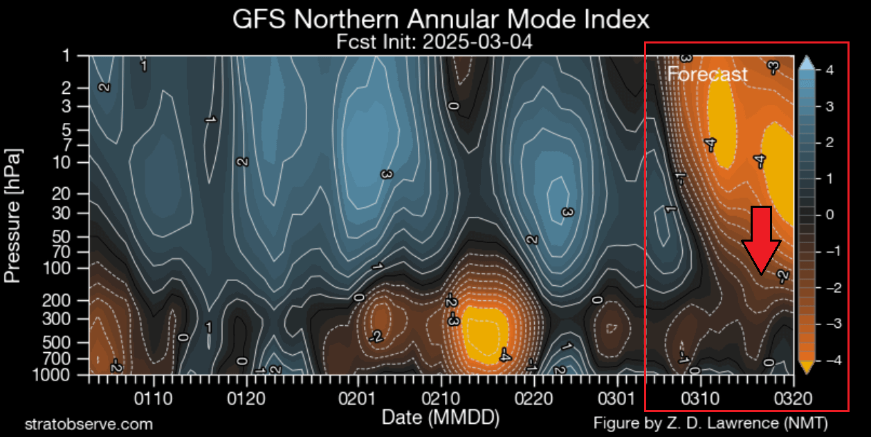
The reason we monitor the state of the Polar Vortex is that it can have a profound impact on our daily weather. We mainly separate the Polar Vortex into two different modes:
A strong/stable Polar Vortex usually means strong polar circulation and jet stream. This locks the colder air into the Arctic Circle, creating milder conditions for most of the United States and warmer-than-normal conditions over southern Canada.
In contrast, a weak/collapsed Polar Vortex creates a weak jet stream pattern. As a result, it has a harder time containing the cold air, which can now escape from the polar regions into the United States and Canada. Image by NOAA.
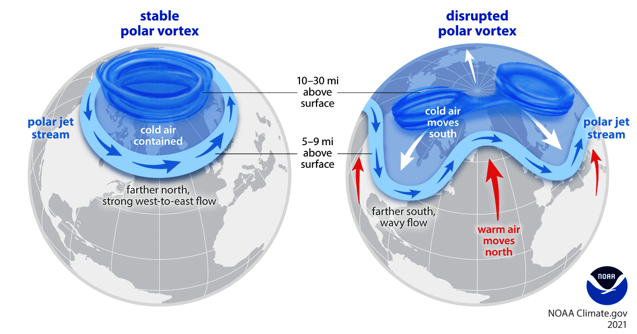
For example, a weak Polar Vortex can greatly increase the odds of cold and snow across the central or eastern United States. In nature, that means a heavy disruption of the jet stream and a release of cold air from the polar regions, depending on the month of the year.
To summarize, the main takeaway should be that the Polar Vortex is the entire weather circulation over the Northern Hemisphere and not just one cold/storm event over the Midwest or the northeastern United States.
THE POLAR VORTEX COLLAPSE BEGINS
Below is the current state of the Polar Vortex in the middle stratosphere at the 10mb level (31km/18.5miles). You can see a large stratospheric high-pressure system starting to grow very large and push against the Polar Vortex. This completely changes the power dynamics in the stratosphere, and you can also see a strong warming wave starting to appear in the outer shell of the Polar Vortex.

This is just the beginning of the stratospheric warming event and the eventual Polar Vortex collapse. You can imagine this event as having a large stack of plates, and as the whole stack starts to wobble around, it can even start collapsing from above, eventually bringing down the whole stack.
You can better see the extend of this event if we look at the current pressure anomalies at the same level of the stratosphere. There is a large high-pressure anomaly growing around the Polar Vortex. Combined with the warming wave that will be getting even stronger, this marks the final days for the Polar Vortex this season.

Even if we look further below at the 50m level in the lower stratosphere, we can see the strong warming wave reaching all the way down, which is impressive to see with this magnitude. The Polar Vortex itself is still stable at this altitude for now, but the high-pressure area effect will also reach down to this level.

To summarize again, a major power shift is starting in the stratosphere, marking the full collapse of the Polar Vortex. Depending on the pressure anomalies in the lower levels and how it connects down, such an event can substantially change the weather patterns across the United States and the rest of the Northern Hemisphere.
One of the main indicators of the Polar Vortex power are the westerly (zonal) winds around the polar circle in the stratosphere. Below is the Polar Vortex wind forecast, and you can see that in the coming days, the stratospheric westerly winds will drop substantially. Going into next week, the winds will reach negative values.
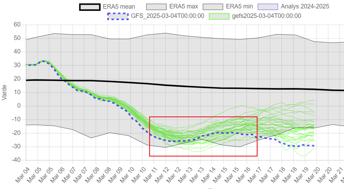
Negative values mean that the winds have actually fully reversed from westerly to easterly. You can also see that the forecast takes it on the edge of the gray area, which is the historic minimum limit. This means that the upcoming Stratospheric Warming event (SSW) will be one of the strongest at this time of year. Image by weatheriscool.com
A FULL COLLAPSE IN THE STRATOSPHERE
In the image below, you can see the ensemble forecast for wind and temperature in the mid-stratosphere. A strong reversal of westerly winds into easterly can be seen on the top graph. That reversal is the main criteria for this to be classified as a major Stratospheric Warming event and marks a total collapse of the Polar Vortex.
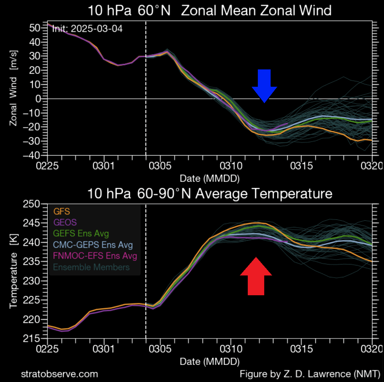
The temperature graph also shows a rapid rise due to a strong warming wave in the stratosphere. The forecast line shows no cooling back, which is a sign that the Polar Vortex will not recover and will not return in any proper form until the next winter season of 2025/2026.
Below is the mid-stratosphere (31km/18.5miles) forecast for 10 days from now in late next week. It shows the stratospheric high-pressure system taking over the polar regions and splitting apart the Polar Vortex. This is the stratospheric warming even at its peak, with the warming wave completely taking over the mid-stratosphere.

We can better see the collapse of the Polar Vortex using a 3D vertical structure forecast below. It shows the deformed and broken shape of the Polar Vortex. You can also see a “void” in its central area, which is the growing high-pressure anomaly and the warming wave that is breaking down the Polar Vortex.

For an even better visualization of how a Polar Vortex collapse looks like, we produced the video below. It shows the full 16-day sequence of the stratospheric Polar Vortex spinning over the Northern Hemisphere and collapsing due to a strong Stratospheric Warming event.
Below is the temperature anomaly forecast for the mid-levels of the stratosphere at 10mb (30km/18.5miles). You can see a strong temperature anomaly over the pole with temperatures in the startospehre being much above the normal for this time of year.

Such a strong, warm anomaly can only be caused by a stratospheric warming event, which is unusually strong for this time of year.
The image below shows temperature anomalies over the polar regions by altitude. The forecast part of the image shows the stratospheric warming wave making its way down across the stratosphere to the upper levels of the troposphere (weather layer).

This raises the main question: What does such strong stratospheric warming mean for the weather below? Before we look at the latest predictions for weather outcomes, we can look at what usually happens during a Polar Vortex collapse.
LARGE-SCALE WEATHER IMPACTS
Sudden Stratospheric Warming basically means a strong temperature and pressure rise in the Stratosphere. That causes a major disturbance in the circulation and, as a result, starts a collapse of the Polar Vortex.
Below, we have a typical vertical progression during a stratospheric warming event. You can see the main event in the stratosphere slowly affecting the surface layers below over a certain time period. In nature, it usually works in the way of the high-pressure anomalies coming down from the stratosphere to the surface.

An SSW event usually means high-pressure anomalies from the stratosphere making their way to the surface. This disrupts the jet stream, helping to unlock cold air from the polar regions down into the United States and the rest of the mid-latitudes.
Below is the actual vertical pressure anomaly image. You can see a high-pressure anomaly in the forecast part of the graphic. It shows the high-pressure anomaly developing in the stratosphere, and it is starting to make its way down as we go into mid-March. It is also starting to show some connection forming to the surface.
Any pressure or temperature anomalies take some time to reach the lower levels. For that reason, we tend to estimate the potential weather impacts in the 0-30 day period after an SSW.
The image below shows the pressure patterns 0-30 days after a stratospheric warming. This is an average image of several different events, but it gives an idea of what we can usually expect. You can see the high-pressure area over the polar regions as the stratospheric warming starts to affect to lower layer of the atmosphere.
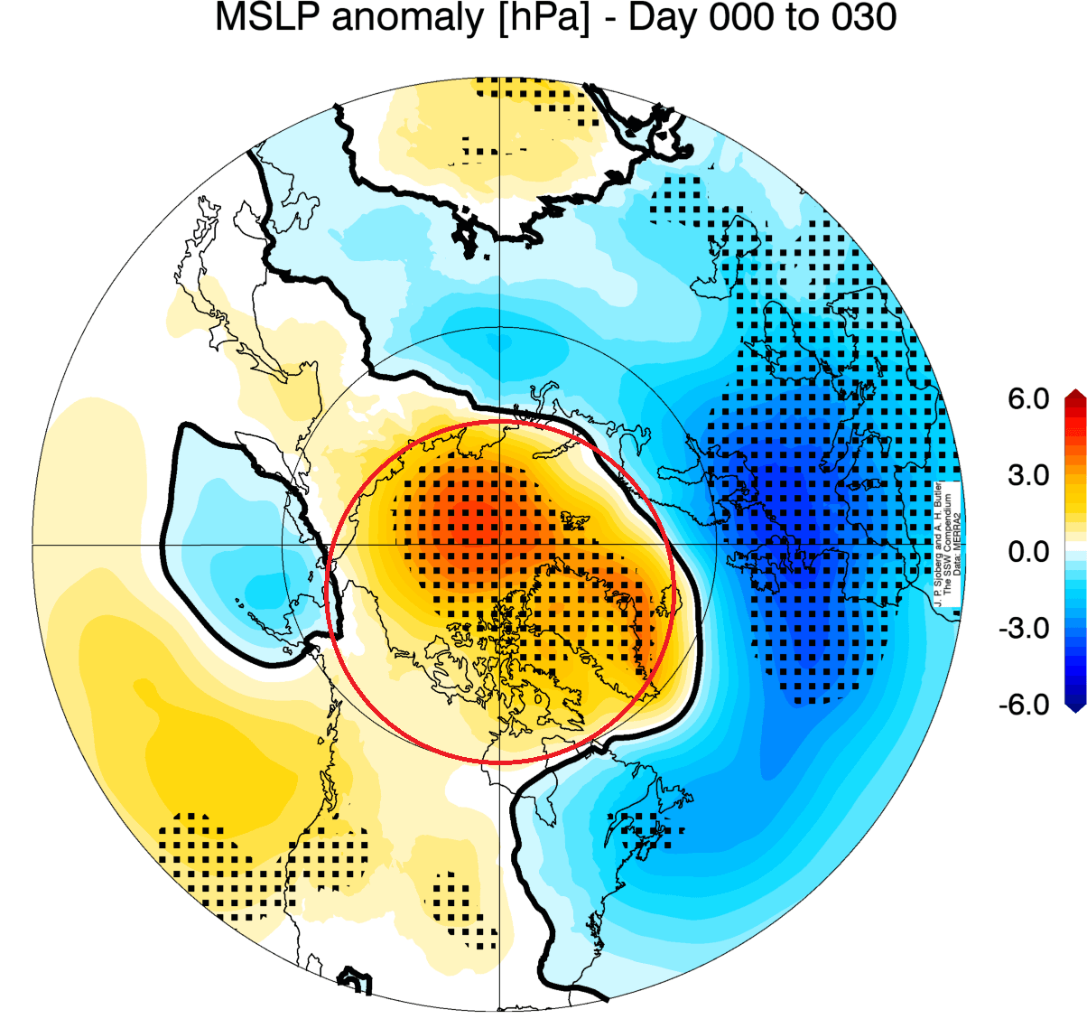
That means a weakened jet stream and low-pressure systems spanning from the eastern United States across the North Atlantic and potentially also Europe. This helps to unlock the cold air from the Arctic, sending it towards the United States, as you can see in the image below.

The images above show an average picture of many SSW events. Each stratospheric warming event is different and does not automatically mean a strong winter pattern.
Knowing how strong the SSW event will be this season and what it usually means for the weather, we can now look at the latest forecasts and predictions for its effects.
FINAL IMPACT OF THE STRATOSPHERE
Below is the latest pressure anomaly forecast for around mid-March. You can see a very interesting pattern over the Northern Hemisphere. We see a high-pressure anomaly over northeastern Canada and Greenland. Compared to the images just above, this is exactly what you expect to see following a stratospheric warming event.

A high-pressure area in that region means the low-pressure systems will be scattered around. You can see one impressive low-pressure area over the United States. One low is over the west coast of the United States, and a belt of lower pressure is over northwestern and northern Europe. Central and eastern Canada is mostly under the high-pressure anomaly.
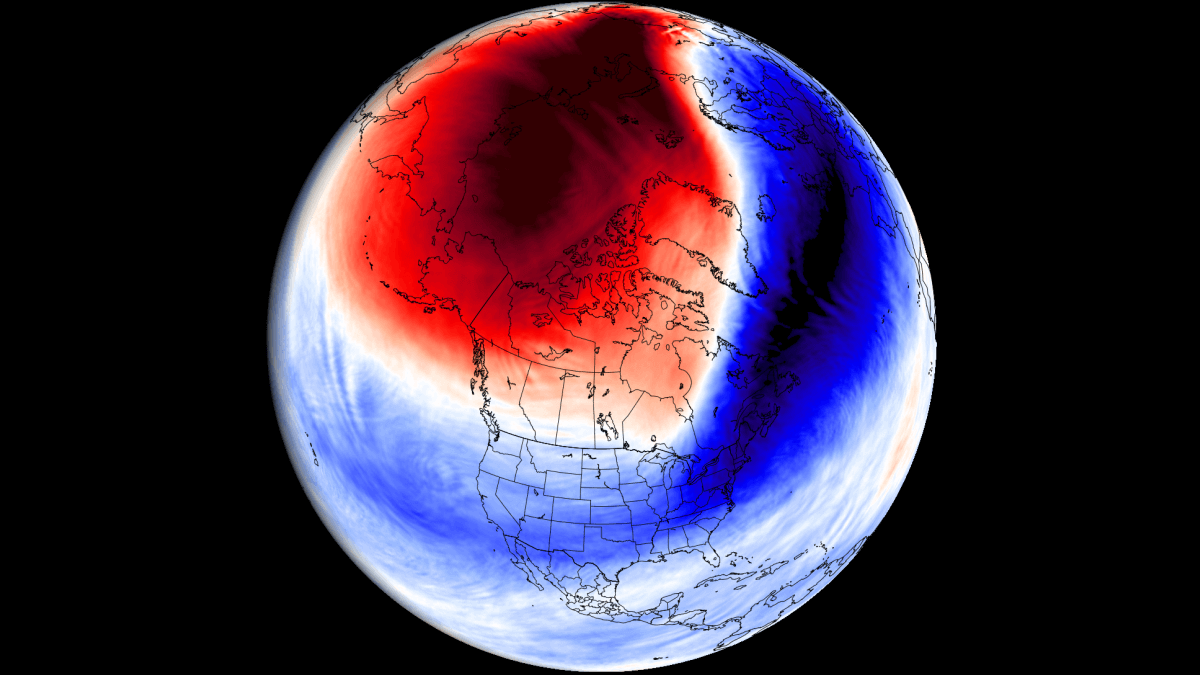
Below is the temperature forecast for the same period. It shows cold air gathering in the central and eastern United States. At the same time, a warm wave is just moving out of the eastern United States and into eastern Canada. This shows the expected response to an SSW event, with the colder air moving into the mid-latitudes.

This forecast range is just starting to reach into the post-SSW period, so for now, we see a colder air mass coming down as the polar regions get higher pressure. Also, a cooler zone is forecast over northern and northwestern Europe due to the high-pressure blocking over Greenland and east Canada.
Looking at North America below, you can see the surface temperature anomaly. It shows a colder air mass returning over the northern and eastern United States. But the whole stratospheric warming process has only just begun, and it takes some time for the models to grasp it properly and predict the final outcome.

The GFS model from the U.S. NCEP center shows a similar example. Cold air is gathering over southern Canada and is being released into a large part of the eastern United States. This is a textbook pattern that we can see after an SSW event. But this is a single-run model, so we only consider it a trend or suggestion for a possible outcome.

Another single-run model below shows a similar story. A colder airmass is forecast to spread across the central, eastern, and northeastern United States. This is just one of the possible scenarios, but all are consistent with a weather pattern that is usually expected after the Stratospheric Warming event.

So, to summarize the effects of the 2025 Stratospheric Warming event, we currently see different predictions pointing toward a high-pressure anomaly over Greenland and eastern Canada. That enables low-pressure systems to dance around, pumping colder air occasionally from further up north into the central and eastern United States.
We will keep you updated on the global weather pattern development, so bookmark our page. Also, if you have seen this article in the Google App (Discover) feed, click the like button (♥) there to see more of our forecasts and our latest articles on weather and nature in general.
Don’t miss: A warm wave over Europe this week