Winter storm has just exited the East Coast and the Northeast, but there are another blizzard and ice storm forecast to hit the Midwest of the United States this coming week. A significant snowstorm could locally dump a foot of snow on Tuesday into Wednesday, but the highest concern is the potentially damaging ice storm across Kansas through southeast Nebraska and Iowa.
It has been one rough winter ride across the United States this month and the weather really wants to finish 2020 with a bang. Just days after winter weather hit East Coast, yet another significant winter storm is coming up this Tuesday, bringing lots of snow and also dangerous freezing rain across the central parts of the country.
A mix of rain, freezing rain, sleet, and snow are expected across the Midwest on Tuesday into Wednesday. Dangerous driving conditions are likely to develop.
New model guidance hints at an increasing potential for a significant amount of ice accumulation possible from Kansas across southeast Nebraska and Iowa into northern Illinois on Tuesday into Tuesday night.
Significant ice accumulations are possible across the highlighted ‘ice storm’ areas with moderate to heavy rainfall likely further south.
To the north of this icy corridor, heavy snowfall and blizzard conditions are expected. Dumping up to a foot of fresh snow over a period of about 24 hours from Tuesday into Wednesday morning. Strong winds will result in high snowdrifts.
Over Kansas, 1-3 inches (3-7 cm) of snow is possible to the north of the freezing rain area, roughly north of I-70. Much more snow will accumulate further north into Nebraska.
Attached below is the progress of this new winter storm across the central United States from Monday through Wednesday, with a developing a surface low in the lee of the Rockies and deepening while moving across the Midwest and towards the Great Lakes. The temperature animation also shows an impressive advection of warm air mass to support freezing rain over Kansas.
The winter storm forecast this week will set the stage for a white New Year celebration for residents across parts of the country.
Important: Keep in mind that just small changes in the storm’s track or temperature forecast could result in significant changes in precipitation type and therefore, higher/lower snow or ice accumulation amounts.
Let’s see some further details on how the last winter storms of the 2020 year will unfold and what are its main potential weather hazards.
A NEW WAVE MOVES ACROSS THE UNITED STATES
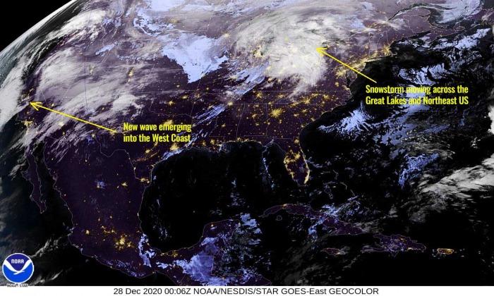
A potent deep low in moving into the West Coast this Sunday and is expected to continue across the United States through the early days this coming week. Its result will be a dangerous winter storm across the Midwest on Tuesday.
We can also see a decaying upper wave over New England and the Northeast of the United States on the far right. This wave is dumping quite some snow over the Great Lakes region and parts of southeast Canada this Monday.
The main wave crossing the central US is gradually weakening while moving northeast, but its active frontal system will result in a significant amount of snow and possibly also ice accumulation across the Midwest.
On Wednesday and Thursday, the wave is forecast to split into the deep South and could turn into another massive winter storm moving across the country on the first day of the New Year 2021. We will post more details on this in the coming days.
The frontal system will first develop a significant snowstorm and dump a lot of snow across the Rockies through Monday night, then moving into the Great Plains to their east by Monday night into early Tuesday.
WINTER STORM DEVELOPS ACROSS THE MIDWEST ON TUESDAY
The surface low forming to the east of the Rockies will do its typical result, pump the high moisture from the deep South (Gulf of Mexico) towards north. This normally means an increase of precipitation as winter storms drifts into the Great Plains and Midwest on Tuesday.
Although the storm will bring quite some rain over the Southern Plains, the weather forecast further north calls for significant winter precipitation with ice and snowstorms on the menu.
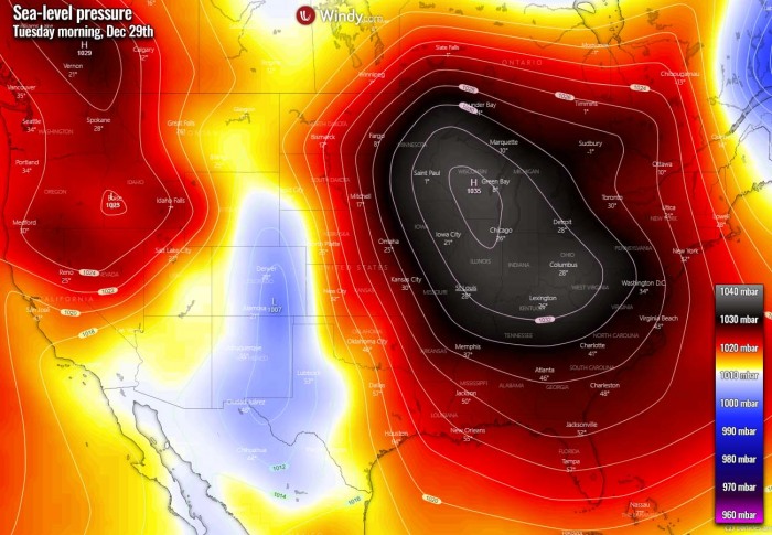
The general pattern on Tuesday reveals that the surface high-pressure system will remain across the Midwest and the eastern half of CONUS, while we can see the secondary low over Colorado, forming in the Lee side of the Rocky Mountains. Both favor the east-southeasterly surface winds through the lowest layers.
But the near-surface layer keeps maintaining cold below-freezing temperatures across Iowa, Nebraska, and most of Kansas as winds are relatively weak near the ground.
This sets a stage for heavy snow later on Tuesday. But at the same time, warm advection becomes quite significant from the south.
Winds will also increase and combined with heavy snow, it will lead to blizzard conditions in some areas from Nebraska through Iowa and Wisconsin. A blizzard occurs when the sustained winds are greater than 35 mph and visibility is strongly reduced. Typically less than 0.25 miles (0.4 km) for several hours.
The precipitation starts to increase by early Tuesday morning as moisture spreads across the Great Plains. Attached below is the precipitation type in the morning hours, indicating there will be heavy snow developing across Nebraska and the Dakotas.
But we can also see that freezing rain is expected to develop across a large part of Kansas. Despite the temperature at the surface are cold, the temperatures aloft are warming up fast with the advection towards the deepening low over Colorado. Winds will be southerly aloft.
As the advection continues through the day, warm southerlies will also mix the temperatures down to the surface from Oklahoma into southern Kansas, therefore freezing rain will turn into rain only.
WARM ADVECTION INTO KANSAS, NEBRASKA, AND IOWA
By the Tuesday afternoon hours, the surface low shifts from Colorado into Kansas and the Panhandles. The large High over the eastern United States shifts to the East Coast. Winds turn more southerly in between this large-scale system, as also pressure gradient increases.
This pushes the warm advection further north, reaching southeastern Nebraska, northern Missouri, and southern Iowa until the evening. It remains cold to the north of the warm front, over the rest of Nebraska, Iowa, and northern Illinois.
Forecasts through the parcel layers over Kansas on Monday night reveal that there are temperatures several degrees below freezing across the lowest 1000 m above the ground. But then, much warmer temperatures are seen and also are expected to improve above this layer as strong warm advection pushes in.
Therefore, the temperatures aloft will be much warmer compared to those in the layer beneath. This is a classic strong thermal inversion, so the forecasted precipitation will support heavy freezing rain there.
DANGEROUS ICE STORM DEVELOPS
The central Great Plains are often prone to some dangerous ice storm events, as the systems coming out of the Rockies and strengthen towards the Midwest. They typically bring warmer air mass north, while freezing temperatures are still present in the lowest level near the ground.
One destructive ice storm event occurred incredibly early this year, at the end of October in Oklahoma, and brought catastrophic tree and power lines damage across part of the state.
The winter precipitation is forecast to begin across the Panhandles on early Tuesday, gradually intensifying and increase in coverage across Kansas and Nebraska through Tuesday.
Heavy snow shifts further east into eastern Dakotas and northern Iowa, while to the south freezing rain is moving closer towards southeast Nebraska and southwest Iowa.
Attached is the weather forecast for the total amount of freezing rain by Pivotalweather weather model NAM. A broad corridor from southwest Kansas into southeast Nebraska, Iowa, and northern Illinois could see between 0.25 and 1.0″ (1-2.5 cm) of freezing rain, therefore ice accumulation (black ice*).
Such an amount of ice could locally lead to tree damage and power outages due to power lines damaged as tree branches crashing down. The weight of ice accumulating normally becomes quite significant once the ice thickness is more than 0.75 in (~2 cm).
*black ice – is ice that has developed (accumulated) on the surface of a roadway. It is transparent but takes on the color of the surface of the road it is on. When ice gets wet from the outside temperatures warming up, it becomes dangerously slick and it has lead to numerous deadly road accidents across the world.
The latest high-resolution NAM weather model guidance is hinting at the highest amount of ice accumulation across central and northeast Kanas, also across far southeast Nebraska and southwestern Iowa. These areas seem in the prime position for a dangerous amount of ice thickness.
The event is indeed strongly dependent on the convective nature of the precip, as some sleet could also occur at times during rain.
As even colder temperatures will be present and the ground is cooling further with lower temperatures, the ice should accumulate even faster and result in an ice thickness rather quickly.
The greatest snow and ice accumulations in this ice storm event are expected from Tuesday morning into Wednesday morning.
What is freezing rain and sleet?
The freezing rain forms when a layer of warm air aloft is placed above a layer of below-freezing (subfreezing) air at the surface. Snowflakes that falling towards the ground, melt as they fall through this warm layer.
If the flakes are completely melted, then it is falling as rain towards the ground which is much colder. This liquid droplet then freezes on contact with exposed surfaces.
Sleet or ice pellets are a form of precipitation consisting of small, translucent balls of ice. Ice pellets are smaller than hailstones and are different from graupel. Ice pellets often bounce when they hit the ground or other solid objects (e.g. jackets, windshields, and dried leaves). They generally do not freeze into a solid mass unless mixed with freezing rain.
WINTER STORM MOVES ACROSS THE MIDWEST INTO WEDNESDAY MORNING
The pattern over the country is a rather progressive one this week, so the winter storm progress towards the northeast is quite fast. During Tuesday night, it is already reaching the eastern portions of the Midwest and spreading into the Great Lakes region.
In the wake of the upper wave, a high-pressure system establishes at the surface across the western United States.
This will change the winds over the High Plains, bringing colder air mass into Nebraska and western Kansas. Therefore precipitation should favor snowfall again. But no significant amounts are expected as the strongest moisture advection is already further east. But will at least become much colder into Tuesday night again.
Warmer temperatures continue their progress northward further east, across the Midwest towards the north, reaching central Iowa and southern Wisconsin by Tuesday evening hours and remain into Wednesday morning.
Heavy snow develops into Minnesota and Wisconsin, continues across northern Iowa. But the warm advection is also dragged further north with the progress of the frontal system, so it keeps the corridor across south-central Iowa and northern Illinois with freezing rain.
Ice storm should continue into the night hours there, but gradually weakening into Wednesday morning as temperatures finally mix the freezing layers near the ground. Therefore rain only should reach these areas.
Further south across southern Kansas and Oklahoma the warm advection will be quite significant, bringing a lot warmer and moist air and become conducive for storms to develop as well. Heavy rain and local flash floods will be possible there.
SIGNIFICANT SNOW AMOUNT ACROSS THE MIDWEST
This new winter storm could bring quite a lot of snow in some parts of the northern United States by Wednesday morning. A significant snowstorm developing could locally dump a foot of fresh snow.
According to the latest model guidance, the highest amounts of snow are expected over the central Rockies, as a result of heavy snow during the strengthening frontal system on Monday. The winter storm then emerges into the Great Plains and drifts across the Midwest on Tuesday into early Wednesday.
Up to 15 inches of snow seems likely across the south-central Colorado mountains. 5-8 inches over central Nebraska and close to a foot of snow from portions of northern Iowa across southern Wisconsin. A couple of inches of snow are expected across the Dakotas as well.
Indeed it is important to note that just a small change in the storm’s position and movement brings different temperature forecast and therefore result in quite significant changes in precipitation type and therefore, higher/lower snow or ice accumulation amounts.
Attached below is the GFS and ECMWF weather model comparison regarding the forecast of winter precipitation as snow across the central United States. While both models agree about 5-8 inches of snow across central Nebraska, the ECMWF is hinting at warmer temperatures across the south-southeast parts of the state.
Therefore just a couple of inches of snow could result if this model verifies. But the ECMWF is colder over southwestern and central Iowa, therefore more snow is forecast there by this model.
While the GFS is actually much more aggressive with the snowfall amount across southeast Nebraska as we can see. This is exactly the case we have described a few lines back. The amount of snow is strongly dependant on the temperature forecast.
In other words, this means that the GFS model hints at less strong warm advection which would put southeast Nebraska out of the significant ice storm potential.
Both models agree on a decent amount of snow over cesntral and eastern Iowa. And easily in good agreement for the central Rockies as well.
So the forecast amount of snow south of and along the frontal boundary from western Kansas into southeast Nebraska and central Iowa is very hard to predict. A couple of inches of snow seem likely at least at the end of this winter storm event, however.
Don’t miss a chance for a nice gift for your friends, family or someone special… Weather calendar could be the perfect gift for them – see below:


