The statistical peak of the tropical storm season in the Pacific Northwest has arrived as the active 2023 season continues with three impressive tropical storms in progress in the region at once. Intense former Super Typhoon Saola is directly threatening Hong Kong overnight. At the same time, Typhoon Haikui continues to intensify and is taking aim at Taiwan, and Tropical Storm Kirogi builds further east near the Japanese Ogasawara or Bonin Islands.
Typhoon Saola threatens to impact Hong Kong as one of the city’s worst weather events in years. In anticipation of significant impacts, Hong Kong businesses and financial services are closed, and authorities were forced to suspend all school classes, reduce public transport services, and cancel 460 flights in and out of the city on Friday. Meanwhile, in Southern Guangdong Province, 85,000 fishing boats have returned to their harbors, and almost half a million people have been evacuated.
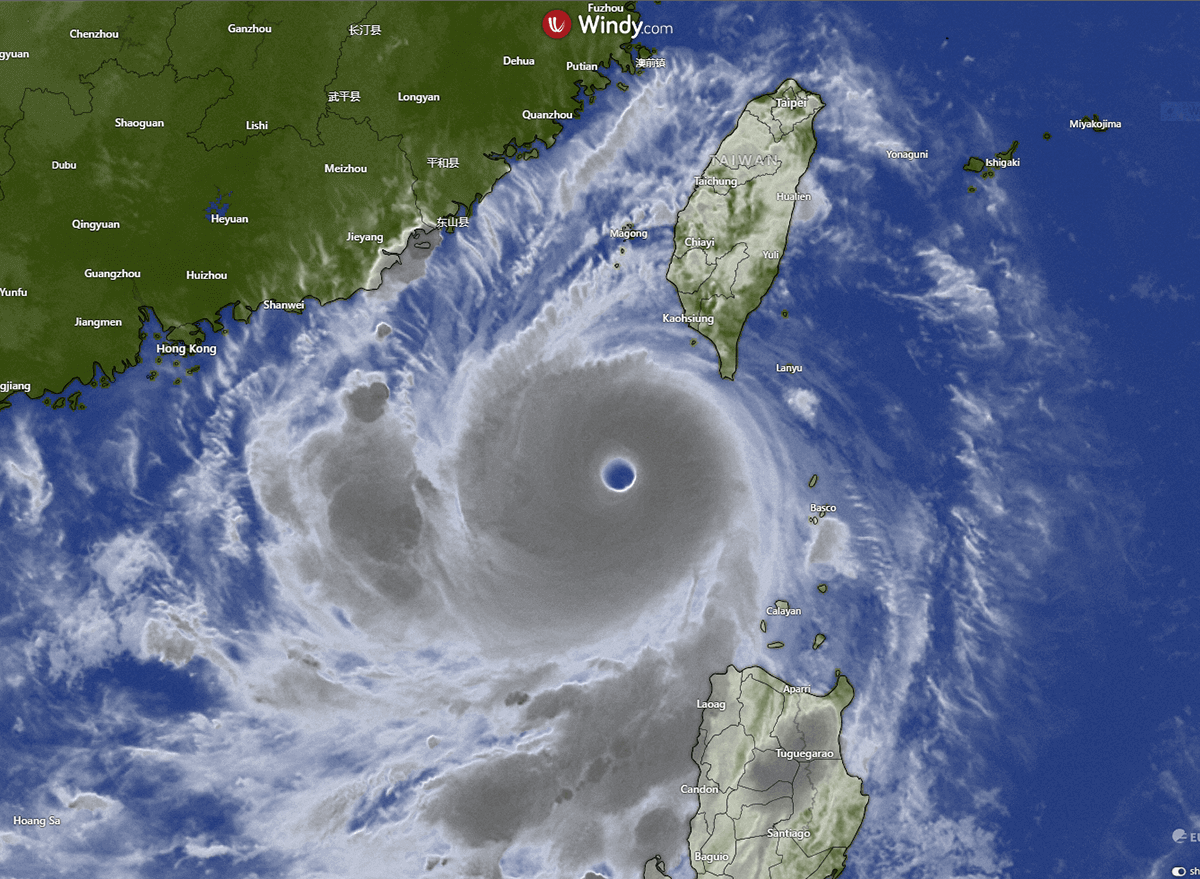
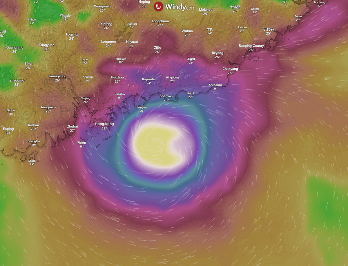
The image above shows Typhoon Saola had developed a very sharp, distinct eyewall and spiral cloud banding as it slowly moved to the south of Taiwan and westward towards China in recent days. At the time of writing this article, Saola had moved within 30 kilometers of the Hong Kong coast, and there are reports the storm had developed a double-eyewall structure, which is a sign of a powerful typhoon.
In recent months, Typhoon Saola and Typhoon Haikui are the latest in a string of powerful Tropical Cyclones in the region. The most notable storms include the violent Super Typhoon Mawar from May into early June, Typhoon Guchol in early June, Typhoon Talim in mid-July, the strong Typhoon Doksuri in late July, and more recently, Typhoons Khanun and Lan that occurred in quick succession in late July through mid-August.
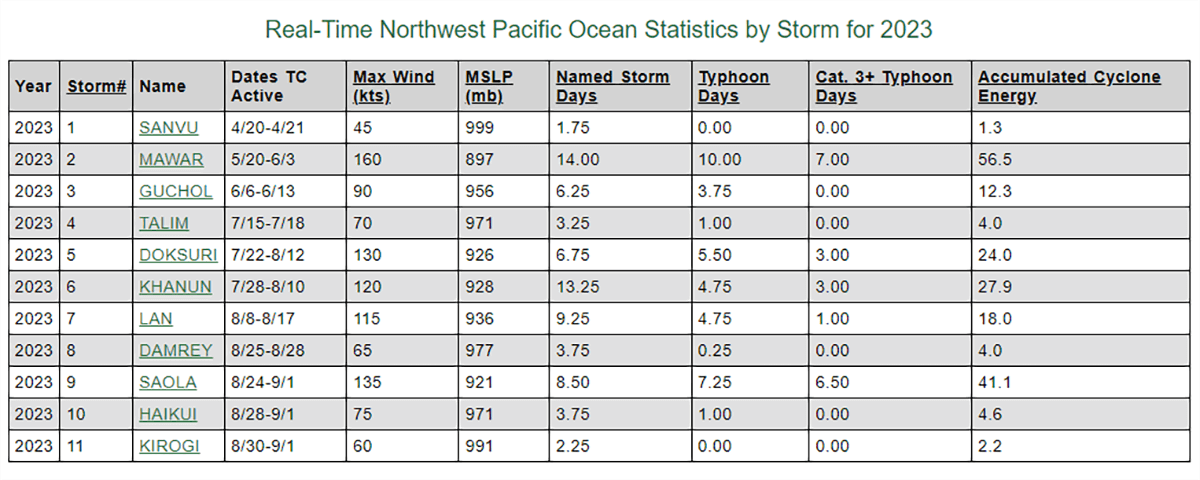
The 11 Tropical Storms in the Pacific Northwest so far in 2023 – Colorado State University
The active season so far should come as no surprise, however, because each year, the Western Pacific region is the origin of more tropical cyclones than any other ocean basin in the world. Almost one-third of all global tropical cyclones form in the region. This relentless production line of tropical cyclones includes an annual average of over twenty typhoons. It is made possible, in significant part, due to the consistent presence of warm equatorial waters throughout the whole year.
HOW POWERFUL IS TYPHOON SAOLA, AND WHAT DAMAGE CAN IT CAUSE?
Saola reached Super Typhoon status earlier this week, leaving at least one person dead and almost 400,000 people displaced across the Philippines after triggering floods and landslides in the nation already battered by several typhoons recently. As shown in the table above, Typhoon Saola is the second most powerful storm in the Northwest Pacific region in 2023, second only to Typhoon Mawar.
Even though Saola weakened somewhat recently, it maintained sufficient strength to remain a powerful Typhoon, equivalent to a Category 4 hurricane, as it slowly crossed the South China Sea.
According to the Joint Typhoon Warning Centre (JTWC) earlier on Friday, Typhoon Saola was located approximately 69 nautical miles east-southeast of Hong Kong, had tracked west-northwestward at 9 knots over the past six hours and had a minimum central pressure of 935 millibars (hectopascals).
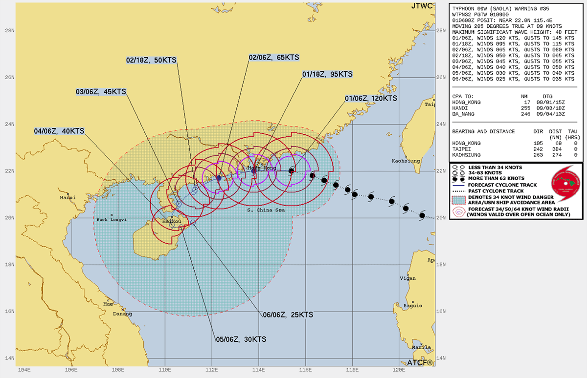
The projected path of Typhoon Saola – Joint Typhoon Warning Centre (JTWC)
Current data on Friday evening indicates that Saola is producing sustained winds of 120 knots (220km/h) and gusts to 145 knots (270km/h), as well as impacting areas up to 100 miles (160km) away with winds to 34 knots (63km/h) as it approaches Hong Kong. The storm is expected to weaken rapidly as it interacts with the landmass and moves southwestward along the coast towards Hainan Island.
Typhoons are a regular occurrence in coastal areas and cities like Hong Kong, particularly during the peak of the tropical storm season, which we are in the midst of now. Without adequate planning and investment in infrastructure and engineering solutions for the wind and rain that typhoons such as Saola bring, cities in the path of such powerful and relentless storms could suffer catastrophic damage and system failures.
According to ReliefWeb, consultancy firm ARCADIS has ranked Hong Kong as third in the world and highest in Asia as the city with the highest risk of disasters. Located east of the Pearl River estuary on the coast of Southern China, the densely populated city of around 7.5 million people is hit by an average of six tropical cyclones yearly. Obviously, direct hits from the most powerful tropical cyclones like Typhoon Saola are not as common, but through necessity, Hong Kong’s infrastructure is engineered and designed to endure the strong winds, floods, and ocean surges expected from such storms.
Interestingly, the severity of the impact of typhoons on Hong Kong is influenced by both the structure of the tropical cyclone itself and the orographic effects caused by the natural coastal geography, with the storm’s landfall location playing a crucial role.
Generally, when tropical cyclones make landfall to the west of Hong Kong, they tend to bring more severe weather to the area with damaging prevailing winds, usually from the southeast, compared to tropical cyclones that make landfall to the east of the city with prevailing winds from the northwest that are weaker due to several factors including the location of mountains to the north of the city.
What damage is Typhoon Saola expected to cause in Hong Kong?
Widespread power blackouts, wind damage to structures, and coastal flooding up to one meter of inundation over normally dry land in and near Hong Kong are possible as Typhoon Saola approaches and is likely to make landfall. In addition to the relentless winds and possible ocean surges, rainfall between six to twelve inches is possible, which may lead to urban river flooding and landslides.
HISTORIC TYPHOONS THAT HAVE STRUCK HONG KONG
Typhoon Mangkhut, 2018
Super Typhoon Mangkhut resulted in 500 injuries, the collapse of several buildings, and the uprooting of 60,000 trees. Furthermore, it led to extensive flooding and inflicted damage on numerous coastal areas, necessitating the evacuation of hundreds of residents.
Typhoon Hato, 2017
In 2017, Typhoon Hato wrought widespread devastation upon Hong Kong. At least ten lives were lost, with many more suffering injuries. The typhoon uprooted 5,300 trees and disrupted the power supply. Additionally, low-lying regions like Yue Mun, Tai O, and a Heng Fa Chuen car park were submerged due to flooding.
Typhoon York, 1999
Typhoon York brought record-breaking rainfall to Hong Kong, resulting in widespread flooding and at least two fatalities. The downpour also inflicted significant agricultural losses and uprooted over 4,300 trees. The storm’s fierce winds also dismantled 800 signboards and toppled a crane from a rooftop.
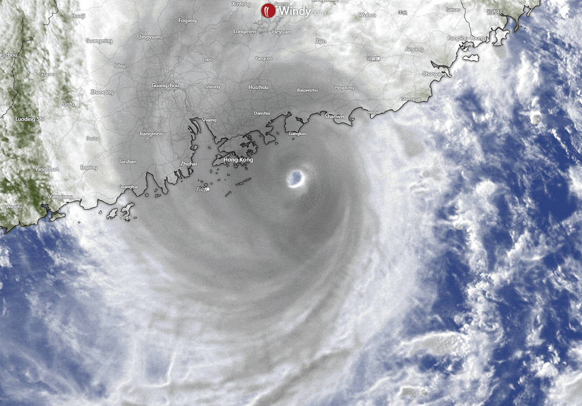
Maximum wind gusts (greater than 185km/h) produced by Typhoon Saola as it approaches Hong Kong today – Windy.com
Typhoon Ellen, 1983
Typhoon Ellen marked the deadliest storm to hit Hong Kong in a decade. It left ten individuals deceased, 333 injured, and 1,600 homeless. Moreover, it caused $50 million of crop damage and prolonged power outages lasting up to four days.
Typhoon Rose, 1971
Super Typhoon Rose ranked among the most powerful typhoons to strike Hong Kong. It caused damage to 300 ships, including a crowded ferry, resulting in 88 casualties. Furthermore, it plunged the entirety of Hong Kong into darkness, damaged telephone wires, and left many individuals trapped in elevators.
Typhoon Wanda, 1962
When Typhoon Wanda made landfall in Hong Kong, entire villages were swept away, leaving over 72,000 people homeless. The typhoon claimed the lives of 434 individuals, and even decades later, communities were still struggling to rebuild their lives due to the sheer intensity of the destruction.
WHERE IS TYPHOON HAIKUI HEADING?
While Typhoon Saola is taking the spotlight and causing ample concerns for Hong Kong, a second typhoon, Haikui, is currently approaching Taiwan and is expected to make landfall on the northern part of the island on Sunday before heading towards the eastern Chinese city of Fuzhou, according to Taiwan’s Central Weather Bureau. The JTWC is forecasting landfall across the central areas of Taiwan on Sunday before crossing the Taiwan Straight towards China in the days after.

The projected path of Typhoon Haikui – Joint Typhoon Warning Centre (JTWC)
And while we keep a close eye on the impacts of Typhoon Saola on Hong Kong and Typhoon Haikui on Taiwan, let’s not forget the third currently active Tropical Cyclone, Kirogi. That Tropical Storm continues to build. Although it may not intensify to a typhoon, it looks set to impact the Kagoshima and Okinawan Prefectures of Japan, which have already borne the brunt of multiple Typhoons this season.
Sources & Credits:
Windy, Tropical Tidbits,
Joint Typhoon Warning Centre
Reliefweb
SCMP News
LifestyleAsia
Colorado State University
Also, see this recent article about the recent Typhoon Lan.