A Stratospheric Warming event is going to start in the coming days. We see a weakening and a split of the Polar Vortex in the forecast, which means the Polar Vortex will be torn into two separate cores. One of these cores is forecast to move over North America, impacting the weather patterns over the United States and Canada in the days and weeks following this event.
When a Polar Vortex is split in half in the stratosphere, each of the remaining cores moves over a different part of the Hemisphere. That means it brings along a weather change and a supply of cold air into the region.
We will focus on the upcoming stratospheric warming event and the Polar Vortex split, with potential winter weather outcomes to follow in February and beyond. But fist, a quick look at what the Polar Vortex really is.
THE NORTHERN POLAR VORTEX
To keep it simple, the Polar Vortex is just a name that describes the broad winter circulation over the northern (and southern) hemispheres. The Polar Vortex extends from the lower levels and high up into the atmosphere.
The lowest level of the atmosphere is called the troposphere, where all the weather events are. But above that, we have the stratosphere, a deeper and drier layer, and the home of the ozone layer.
For this reason, we separate the entire Polar Vortex into two parts: an upper (stratospheric) and a lower (tropospheric) part. They both play their role differently, so we monitor them separately. But both parts together form the winter circulation across the Northern Hemisphere and the resulting weather patterns.

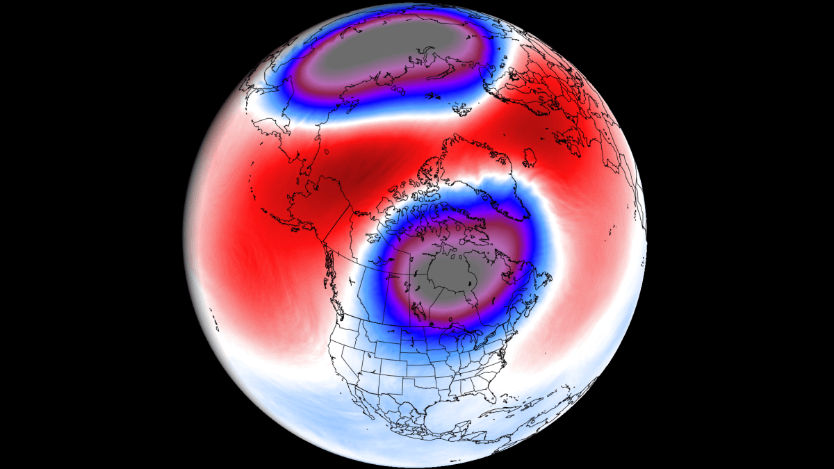
Below, you can see a 3-dimensional image of the Polar Vortex. The vertical axis is greatly enhanced for better visual presentation. You can see an example of the actual Polar Vortex structure across the atmosphere, connecting to the lower levels and the weather patterns below.

To show the Polar Vortex even better, we produced a high-resolution video below, which shows it in 3D, giving you a better idea of how it works. But note that the vertical size of the vortex was greatly enhanced for visual purposes.
The main takeaway from the video should be that the Polar Vortex is not just one winter storm or a cold outbreak that moves from the Midwest into the eastern United States. It is the entire weather circulation over the Northern Hemisphere.
THE DISRUPTION BEGINS
The Polar Vortex is currently starting to get deformed, with a warming wave appearing on the outer edges. The image below shows geopotential height and temperature in the mid-stratosphere at the 10mb level (30km/18.5miles). You can also see the stratospheric “high” growing over the Aleutians.

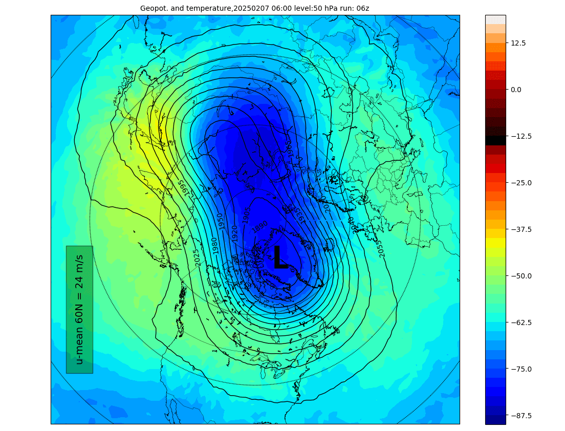
The next image below shows the current temperature and geopotential height in the lower stratosphere at the 50mb pressure level (20km/12.5miles). Here, we can better see how the Polar Vortex is no longer circular but is getting compressed from both sides, squeezing its core towards northern Canada.
You can also see that in the pressure anomaly for the same lower stratosphere level. The image below shows the core getting elongated, with two pressure waves pressing against the Polar Vortex. This process will strain and weaken the Polar Vortex, just like compressing a balloon with your hands until it pops.

But how do we measure the strength of the stratospheric Polar Vortex? The simple answer is the winds. The more organized the stratospheric Polar Vortex is, the stronger the winds around its core, which means it can have a stronger influence on the surface.
Below is the latest analysis and forecast of the stratospheric winds around the Polar Vortex. We are currently still seeing a strong Polar Vortex, but looking ahead at the forecast, you can see a rapid deceleration, and each line goes lower. This is the result of the Polar Vortex deformation getting stronger over time.

To slow down such a strong and large circulation takes a lot of energy. In the stratosphere, that comes in the form of pressure and temperature waves. When we see large deformations and Polar Vortex splits happen, that’s usually initiated by Stratospheric Warming (SSW), which is a combination of strong pressure and temperature waves in the stratosphere.
2025 STRATOSPHERIC WARMING UPDATE
As mentioned above, strong waves from the lower levels send a lot of energy upwards into the stratosphere, manifesting as a rise in pressure and temperature. That helps to destabilize the Polar Vortex top-down, creating a large disturbance in the coming days.
If we look at the polar vortex forecast in mid-February, we can see two very strong high-pressure areas in the stratosphere, splitting the lower Polar Vortex in half and connecting over the pole. This is at the 50mb pressure level (20km/12.5miles). You can see that one core of the Polar Vortex will move over Canada and the northern United States.

While this is in the stratosphere, it does have an impact on the pressure systems above. Usually, we see the main low/high-pressure systems below, moving near the stratospheric cores in such events. So this would indicate a low-pressure weather pattern over the United States and Canada.
Below is the mid-stratosphere pressure anomaly forecast for the same period at the 10mb level (30km/18.5miles). This image shows a split Polar Vortex quite far up in the stratosphere, creating the so-called “daughter vortices”. One of these cores will move over North America and impact weather in the lower levels.

Looking at the temperature anomalies for the same mid-stratosphere level, you can see the stratospheric warming wave over the pole. This shows the strong disruption in the stratosphere and a major shift of the cold Polar Vortex core out of the polar regions and into the mid-latitudes.

Such a split of the Polar Vortex usually means a high-pressure area will build over the polar circle. As the Polar Vortex is split, the remaining cores and the cold air move towards the mid-latitudes. In this case, we see one core move over Canada and the United States.
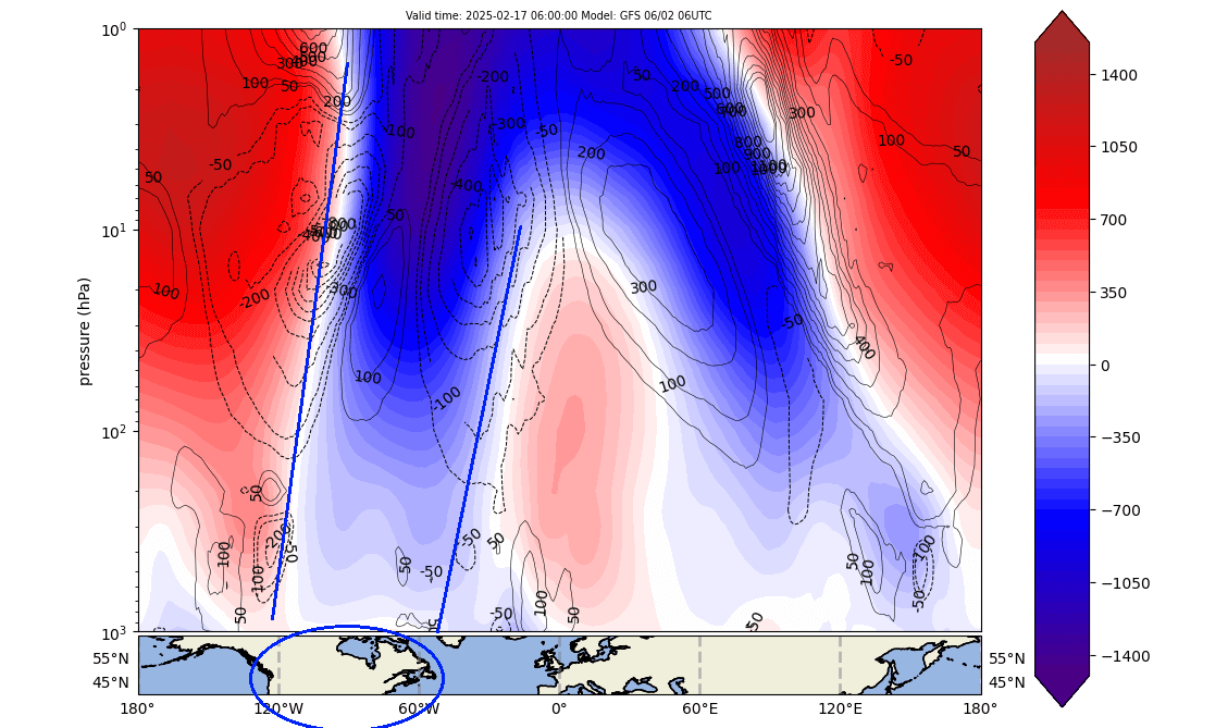
The mid-month forecast image below shows the pressure anomaly by altitude from the surface to the top of the stratosphere. You can nicely see how the Polar Vortex is split in half, with one core connecting directly down into Canada and the United States.
We now know what the conditions will be in the stratosphere, and we know where it will connect down. So, it is time to look at the weather pattern changes below.
WEATHER IN A SPLIT POLAR VORTEX
A Stratospheric Warming (SSW) basically means a strong temperature and pressure rise in the Stratosphere. That causes a major disturbance in the circulation and, as a result, starts a collapse of the Polar Vortex.
Below is the lower-level pressure anomaly following the stratospheric warming, as forecasted by the ECMWF model. You can see the low-pressure anomalies over Canada and the northern United States. This is where the split core of the Polar Vortex sits, making a pressure pattern impact on North America with a northerly flow.

The surface temperature forecast for this period shows a strong cold polar air outbreak across the northern, central, and eastern United States. This is just a single forecast, but it is a 5-day average, and as is something that we typically see after strong Polar Vortex split events.

Looking at Europe, we see a spill of colder air forecast for mid-February. It results from the changes in the weather patterns after the Polar Vortex split. The high pressure over the pole helps to push out colder air, creating a northerly flow over the continent and bringing down a wave of colder air.

Below is the pressure anomaly forecast for the same mid-month period but from an ensemble forecasting system. An ensemble forecast has many different (50+) forecasts merged into one single one, which usually gives more stable forecasts but loses variability as forecast time increases.
The ensembles also show a strong high-pressure area over the polar regions, displacing the low-pressure anomalies and cold polar air towards the United States and Canada. This reflects the anomalies in the stratosphere, with the large Polar Vortex core moving into North America.

The surface temperature from this model shows strong polar cold anomalies over the United States and southern Canada. You can also see the warm anomalies over the polar circle, which replaced the cold air pushed out and down into the United States and Canada.

The main area for the coldest air looks to be over North America, where one of the split Polar Vortex cores will directly move over and impact the regional weather patterns. It will create a northerly flow over the northern half of the United States, with only the southwest and the southeastern U.S. not currently looking at some major cold.
But as we go deeper into February, we are still going to see lasting post-effects from the split Polar Vortex.
LONG-LASTING WEATHER IMPACTS
Below, we have the pressure anomaly forecast for the lower stratosphere at 50mb level (20km/12.5miles), in the final days of February. You can see that the main core of the Polar Vortex is trying to reform, but a large core part will be locked over North America, impacting regional weather.

We can see those impacts in the extended-range forecast for the last week of February. You can see a continued presence of a low-pressure zone over the United States and Canada. While a high-pressure area remains over the pole, this indicates a continued presence of the Polar Vortex core over North America and a sustained northerly flow into the United States.

The temperature forecast for the same period also shows this scenario, with a strong cold airmass spreading across the United States and southern Canada. We expected to see this in the days following a strong Polar Vortex split event, as one Polar Vortex core usually moves over a continent and brings colder airmass into the region.

But looking at Europe, we do not see the cold air anomaly anymore, with the forecast trending back to a warmer pattern. This is because the cold in the United States and Canada is being driven by the actual Polar Vortex core over North America. At the same time, a strong low-pressure system is absent on this side of the Northern Hemisphere.

We will keep you updated on the global weather pattern development, so don’t forget to bookmark our page. Also, if you have seen this article in the Google App (Discover) feed, click the like button (♥) there to see more of our forecasts and our latest articles on weather and nature in general.
The main forecast images in this article are from weatherbell, using a commercial forecaster license.
Don’t miss:
Winter Storm Garnett: A foot of snow expected in the Northeastern United States on Sunday