The active Polar Vortex southern lobe is blazing across the Northern Hemisphere, producing significant cold waves across the North American continent. Two major storms are forecasted this week: Winter Storm Harlow on Thursday and Iliana next Sunday. Powerful snowstorms will blanket the Midwest, Great Lakes, and the Northeast U.S. with up to 2 feet of snow. Freezing rain will be possible again.
The past weekend, a winter storm, Garnett, raced across the Northeast U.S., dumping a lot of snow. But this is a solid start; two more intense storms are coming this week.
Yet another week of significant winter storms is forecast for the United States. Two deep upper waves with associated surface lows will track from the Central U.S. to the Northeast, producing a mixture of heavy snowfall and ice storms along their paths.
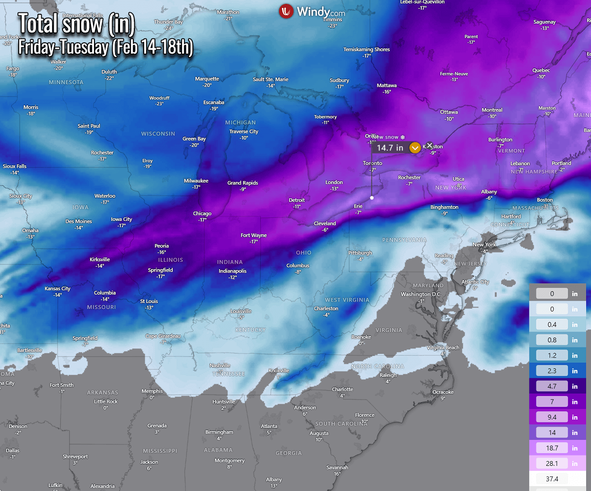
A foot of snow is forecast across parts of Wisconsin, Michigan, and New York, Maine states, including southern Ontario, Canada. Significant snow is predicted for Chicago, Detroit, Toronto, and Montreal.
The weather in North America has been changing since early February. A persistent and intense Arctic cold pool covers most of Canada and the northern half of the United States. In contrast, an unusually warm air mass remains across the South and West.
A sharp temperature gradient exists between the cold on the north and warmth on the south, extending roughly across the middle of the Contiguous U.S. from the West to the East Coast. This week, the Arctic cold wave is forecast to dig more toward the south, triggering a winter storm Harlow on Thursday. This storm will be followed by another storm (likely to be named Iliana by TWC later) on Sunday next weekend.
Below is a short video animation that provides an overview of the developing weather situation across the continent this week and next weekend. Both major winter storms are visible and have a significant impact, with severe storms and flooding in the south and heavy winter weather across the eastern two-thirds of the nation.
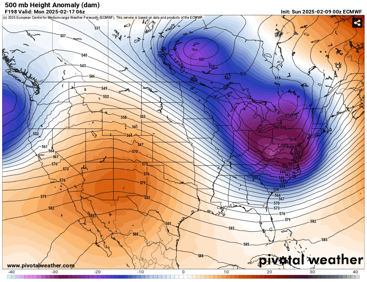
Before we dig into details on the next significant winter pattern evolution, let’s discuss the main trigger behind this wintry pattern over North America this season. The Polar Vortex aloft is very intense this year, and its southern lobe has shifted above the Canadian Arctic, bursting cold outbreaks towards the U.S.
What is the Polar Vortex?
The Earth’s atmosphere has six layers around the planet. Most of the dynamics for our daily weather occur in the lowest two layers, known as the troposphere and the stratosphere.
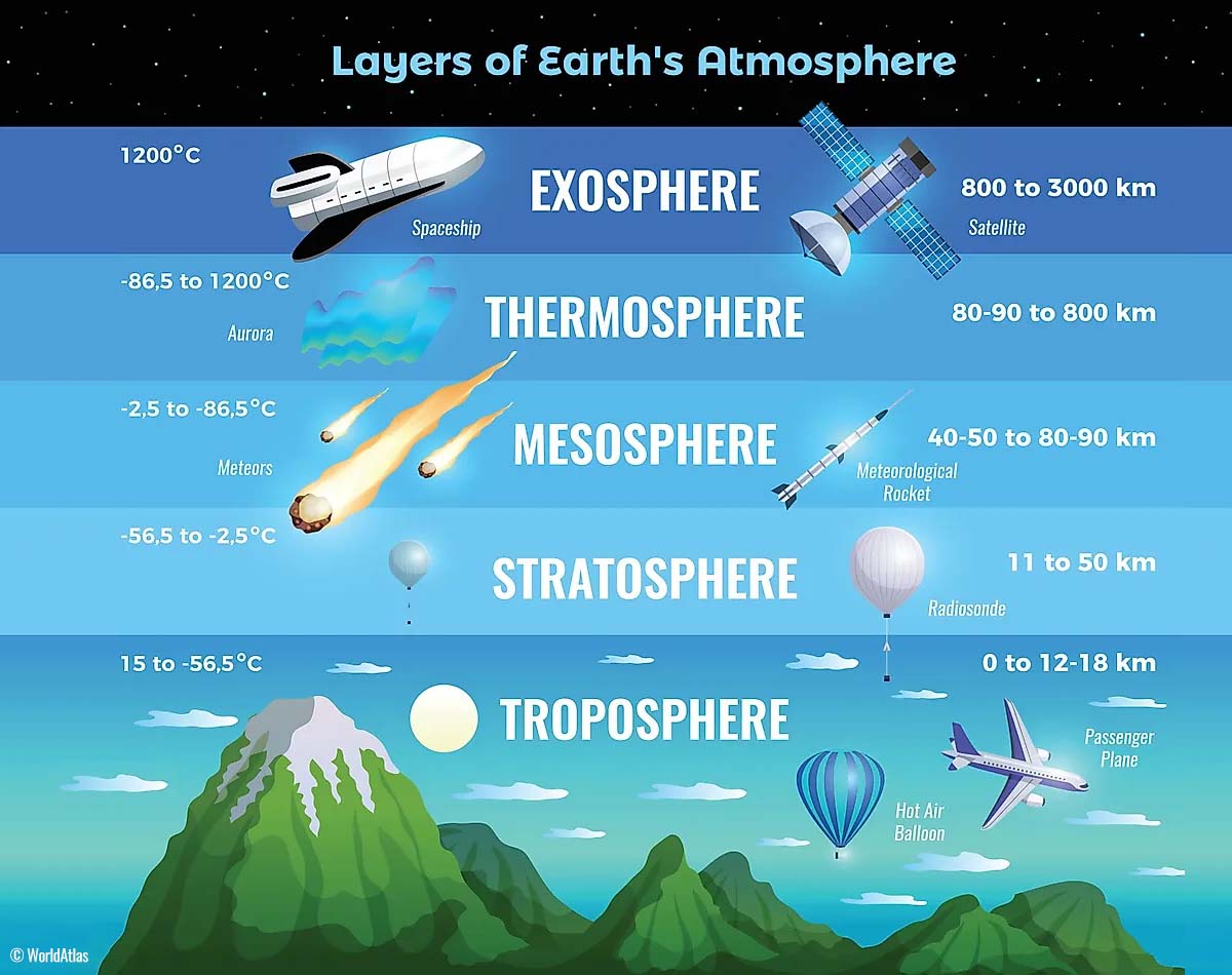
Another essential feature in the stratosphere, which makes our weather even more variable, often triggers significant large-scale and long-lasting winter weather events. This is the Polar Vortex—an enormous, tri-dimensional ring of powerful winds moving through the sky above us. The Polar Vortex is spinning around the North Pole, grazing through the air at about 20-50 km above the Earth’s surface with violent wind speed.
The troposphere and stratosphere are crucial for our climate. The Polar Vortex covers most of the bottom half of the atmosphere. Since the vortex extends from the middle of Earth’s troposphere into the stratosphere layer, it significantly affects winter weather across high and mid-latitudes yearly.
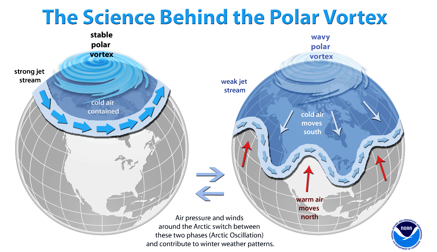
The Polar Vortex is most substantial during winter in the Northern and Southern Hemispheres. Although it spins well above our heads, it remains closely connected with the lowest parts of our atmosphere. Thus, it influences our daily weather in many ways, as it generally functions as one sizeable hemispheric circulation.
The Polar Vortex has triggered the most intense weather systems, from frigid cold outbreaks and winter storms in Canada and the United States to Asia and Europe. Although it affects the whole Northern Hemisphere, its main impact occurs where the southern lobe of the vortex is located.
The active and strong Polar Vortex during the Winter season of 2024/25 was the main trigger behind the robust cold outbreaks in Siberia since January. Then, the most intense part of the vortex, the southern lobe, shifted to the North American side of the northern hemisphere and spread across Arctic Canada towards the U.S.
A deep upper wave barrels across the U.S. by mid-week, resulting in significant winter storm Harlow on Thursday
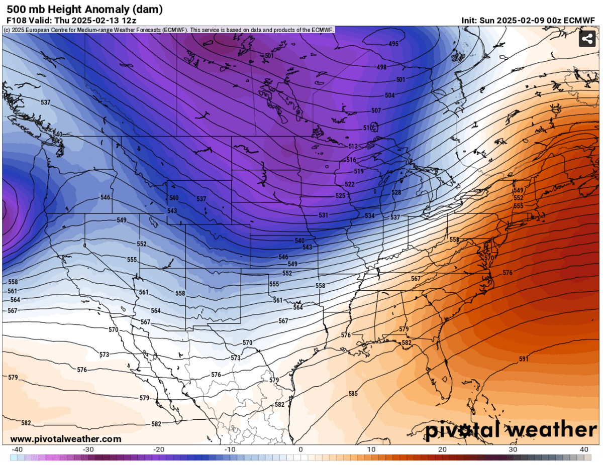
The dominating upper-level circulation over North America, associated with the strong southern lobe of the Polar Vortex aloft, continues to produce multiple waves crossing the continent; by mid-week, one deep wave will move across south Canada towards the Great Lakes and the Northeast U.S.
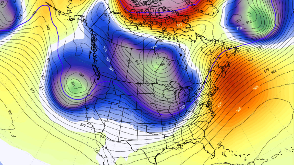
The following chart is a 500 mbar forecast for Thursday. It indicates a powerful deep wave that extended across southern Canada and a large part of the United States, with its core moving toward the Great Lakes. This is where the most significant weather will develop, and a significant winter storm will form.
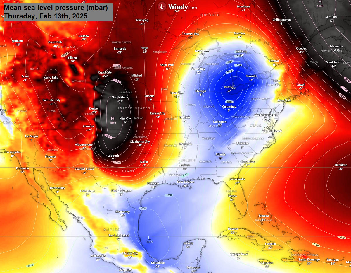
As the wave travels across the northern tier of the United States and southern Canada, it deepens the surface pressure across the central United States. On Thursday, the surface low tracks across the Ohio Valley towards the Great Lakes and the Northeast United States.
Early Thursday morning, the center low will be over Lake Erie, moving northeast, passing Toronto, Canada, and further deepening. This will deteriorate winter storm Harlow, producing significant wintry weather conditions across the region.
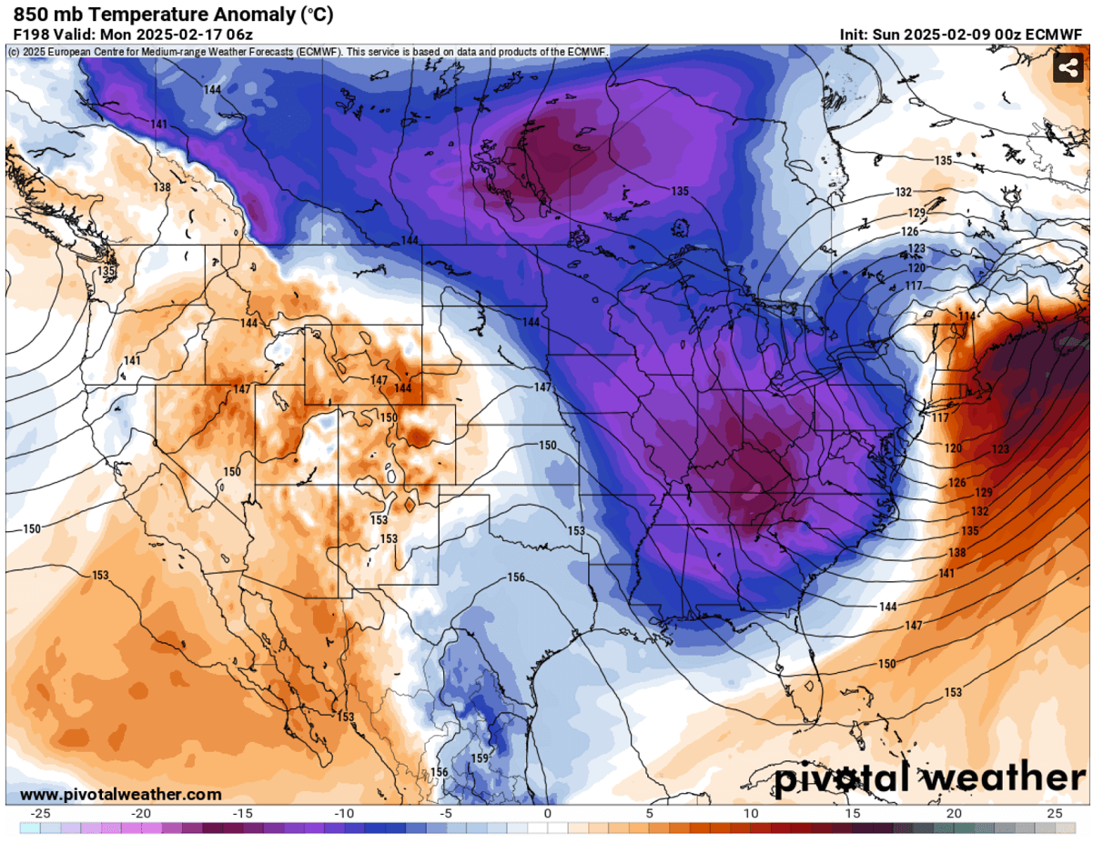
The clash of the two air masses, the Arctic cold blast from the north and the much warmer sub-tropical air mass from the southern U.S.
A sharp temperature gradient will result in intense winter weather, heavy snow with blizzards and freezing rain on the cold side, and severe thunderstorms with heavy rainfall on the warmer side of the storm.
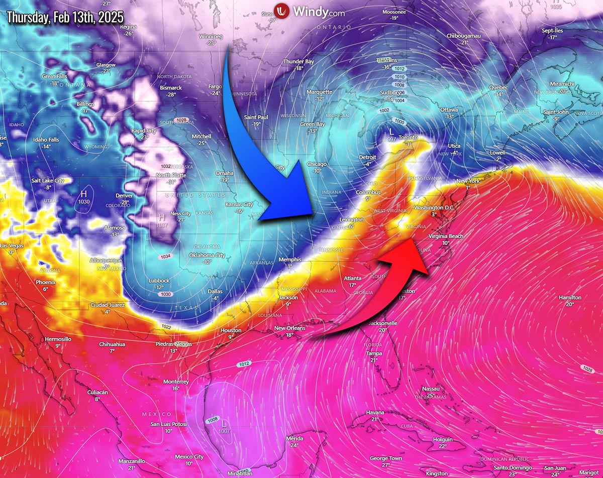
Behind the low, a high-pressure system builds up and spreads the much colder air mass further south across the U.S., reaching the Gulf Coast and pushing below-freezing temperatures as far south as central Texas.
Behind the front, near-surface temperatures will be 15-30 degrees Fahrenheit below normal, with the most significant anomaly occurring late Thursday into Friday morning.
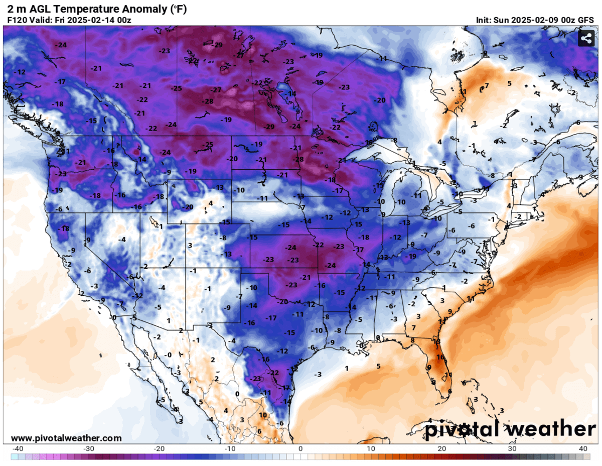
Note: This past weekend, temperatures across most of Texas were in the upper 80s so that the weather will change to more winter-like in just a few days.
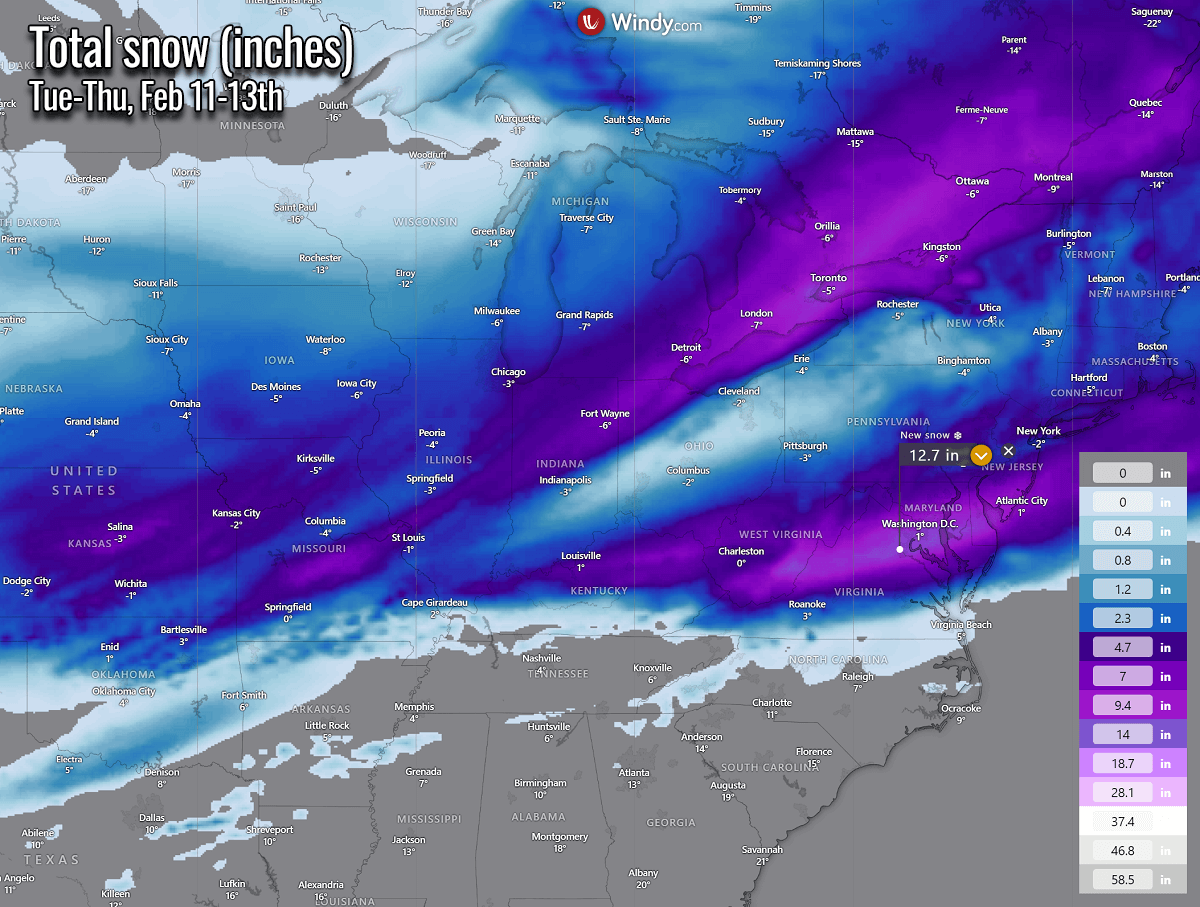
Winter Storm Harlow is forecast to blanket the Upper Midwest, the Great Lakes, and southern Ontario with a foot of snow on Thursday
Winter Storm Harlow will develop across the central Plains on Wednesday. Heavy snow is forecast from eastern Colorado to Kansas, Nebraska, and Iowa. By Thursday morning, the storm will continue intensifying and tracking across the Ohio Valley and the Great Lakes.
The center low will track across the Lakes, defining a sharp contrast between the warmth in the south and the cold to the north.
The following two charts indicate the approximate position of the storm on Wednesday night (left) and Thursday midday (right chart). The sharp temperature gradient along the storm’s path will intensify precipitation. It will bring heavy snow to the north of the warm front and freezing rain with sleet to the south. And heavy rain and thunderstorms further south.
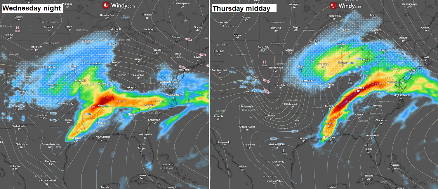
The most significant amounts of snow are forecast across Missouri, Illinois, Indiana, Michigan, and southern Ontario, Canada. Detroit and Toronto could be blanketed with a foot of snow in 24 hours.
Overall, many areas will likely receive more than a foot of fresh snow by Thursday evening, and locally, up to 2 feet of snow will be possible over southern Ontario.
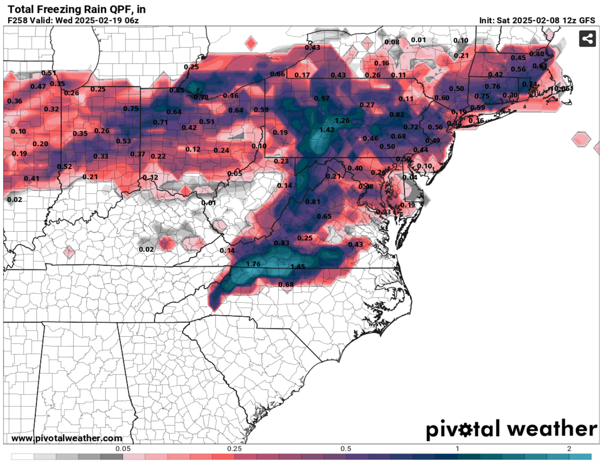
A significant deep low also brings a strong warm advection from the south, which means a much warmer air mass in the mid-levels will overspread the cold conditions beneath. This is a favorable scenario for producing freezing rain and sleet.
Therefore, freezing rain and ice storms are possible across the Ohio Valley, Pennsylvania, Virginia, and West Virginia. Locally, 0.5 to one inch of black ice could accumulate by Thursday evening. Travel disruptions, including power outages and falling trees, are likely to occur.
Further south of the center low, a sharp cold front will likely develop thunderstorms with heavy rain and strong to severe winds from Tuesday evening through Thursday afternoon as the storm will be tracking east.
Widespread rainfall accumulation is forecast across the Southeast U.S. and Mississippi Valley. The general weather model consensus predicts precipitation in the upcoming 10 days from Arkansas to Mississippi, Tennessee, Tennessee, West Virginia, and western the Carolinas to Maryland. Flooding will be possible.
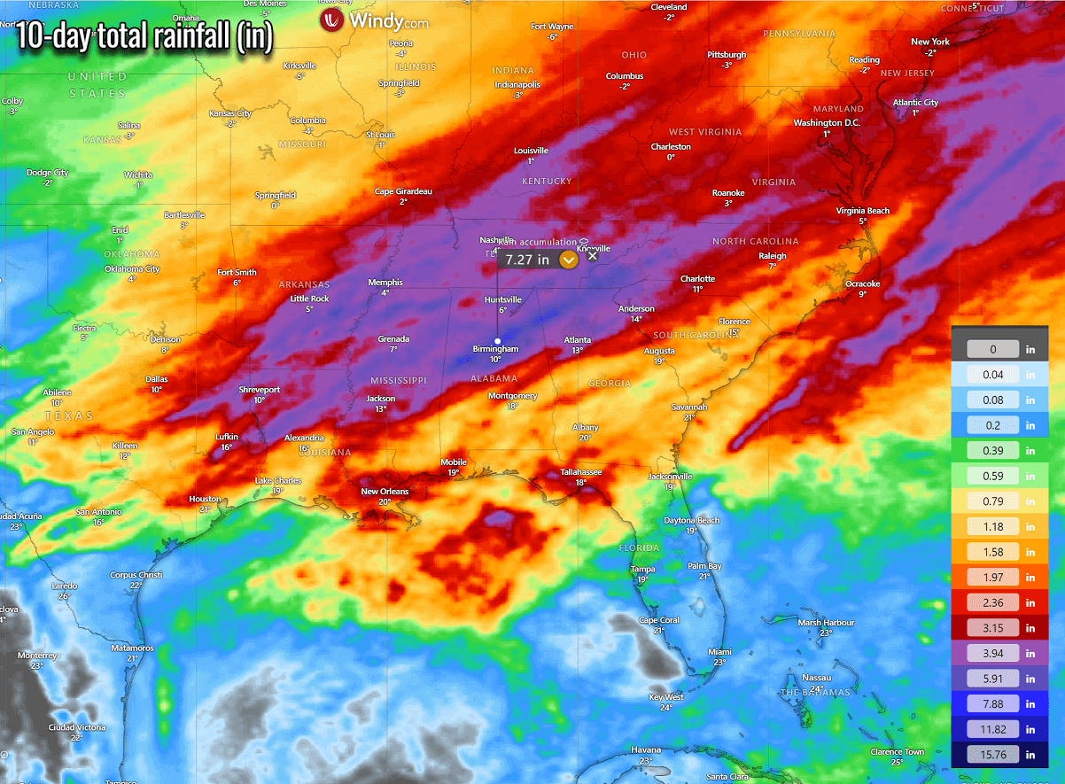
However, at least the first storm on Thursday is expected to bring this precipitation as snow from northern Kentucky across West Virginia and north Virginia to Maryland and New Jersey as heavy snow.
8-12 inches of snow is likely to accumulate, including across Washington, D.C., on Thursday.
Yet another major winter storm next Sunday, with potential for 1-2 feet of snow for the Great Lakes and the Northeast U.S.
With the active Polar Vortex lobe remaining in place across North America, persistent development of deep upper waves and associated winter storms with cold outbreaks will likely follow through the remainder of February. The next significant trough will graze across southern Canada and the Northeast United States the following weekend.
As a result, its southward-spreading cold wave will introduce a surface depression across the Southern Plains and Lower Mississippi Valley on Saturday. The depression will gradually move northeast and significantly deepen on Sunday.
The upper wave will be intense, leading to a fierce surface winter storm from the central to the northeastern U.S. and the Great Lakes. Global weather models hint that this winter storm could be more powerful and significant than Thursday’s storm Harlow.
Despite the event being more than five days away, the central pressure is consistently forecasted into the mid-980s.
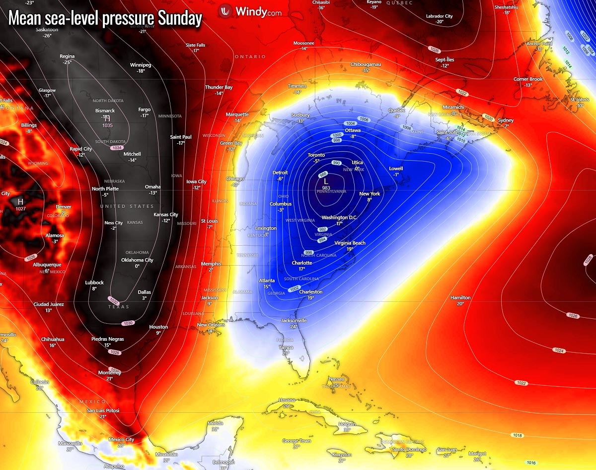
The surface low will move from the Ohio Valley to the Northeast U.S. on Sunday and Monday next week. The path of the following winter storm on Sunday could be similar to that of storm Harlow on Thursday.
This would create intense winter weather conditions. Therefore, another abundant amount of heavy snow, combined with blizzard conditions from Illinois across the northern Ohio Valley and Great Lakes to the Northeast U.S. and Ontario, Canada again.
The extent of the snow and where it will fall are still uncertain, but the weather model agrees that Sunday’s storm could be another 1-2 feet snow event for the region. This could bring more deep snow to Chicago, Detroit, Cleveland, Toronto, and Montreal, Canada.
Paired with strengthening upper and surface High on the west, it will bring another Arctic cold outbreak far south across the eastern two-thirds of the Contiguous U.S. from Sunday into early days next week.
Thus, cold temperatures will drag across the Southeast U.S. and the East Coast. After Sunday, much colder weather will also return to the Eastern Gulf Coast and Florida. And bring temperatures back to 30 degrees F below the average.
We are closely monitoring the evolution of the weather pattern as multiple winter storms develop across the U.S. and Canada. Stay tuned for updates.
Wxcharts, Windy, WeatherBell, and Pivotalweather provided images used in this article.
See also: